
Flash flooding threatens areas from the Tennessee Valley to the Carolinas as storms repeat along a stalled front. Monsoonal storms may trigger flooding in the Southwest. Dangerous heat expands across the Desert Southwest, Plains, mid-Mississippi Valley and Southern Tier. Critical fire weather for interior Pacific Northwest. Cooler, drier air brings brief relief to the Great Lakes and Northeast. Read More >
Overview
|
In the early morning hours of Friday, May 24, 2024, a line of severe thunderstorms moved through the area, producing wind damage and 16 tornadoes (3 EF-1 and 13 EF-0). In all, NWS Omaha issued 14 tornado warnings and 17 severe thunderstorm warnings. The line of storms produced severe weather stretching from western Nebraska all the way to Illinois and was classified as a derecho. |
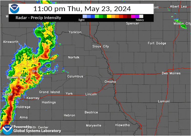 Radar loop from 11 PM through 5 AM |
Tornadoes
|
Seward County Tornado
Track Map 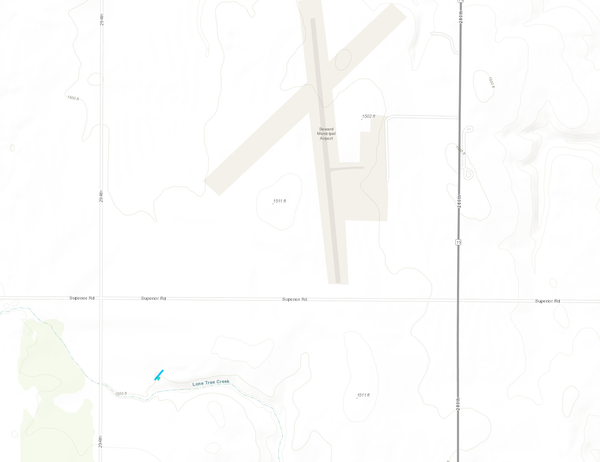 
|
||||||||||||||||
|
||||||||||||||||
|
Woodcliff Lake Tornado
Track Map 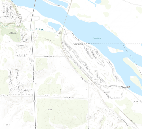
|
||||||||||||||||
|
||||||||||||||||
|
Memphis Tornado
Track Map 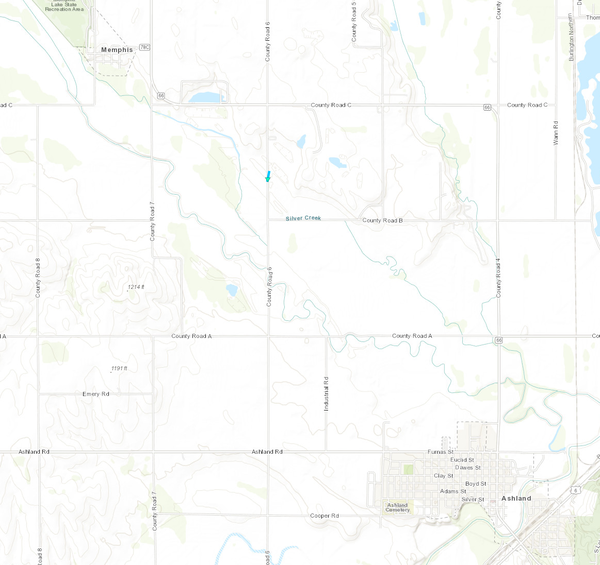
|
||||||||||||||||
|
||||||||||||||||
|
Washington County Tornado
Track Map 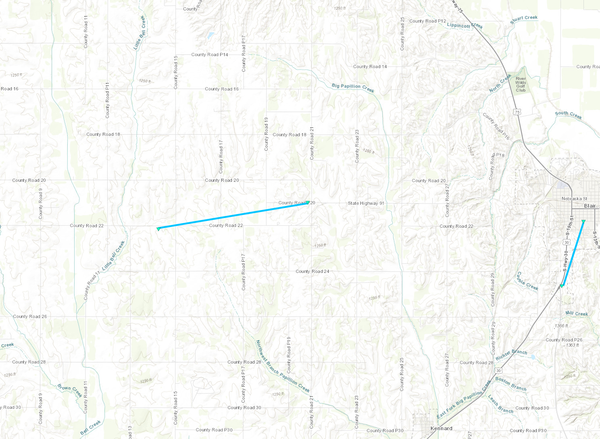
|
||||||||||||||||
|
||||||||||||||||
|
Blair Tornado
Track Map 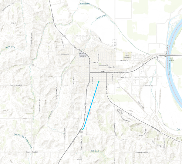
|
||||||||||||||||
|
||||||||||||||||
|
South Gretna Tornado
Track Map 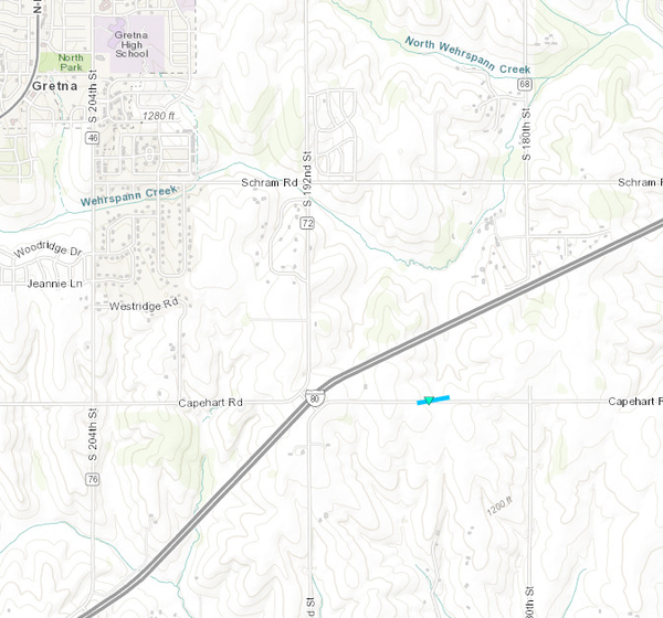
|
||||||||||||||||
|
||||||||||||||||
|
Shadow Lake Tornado
Track Map 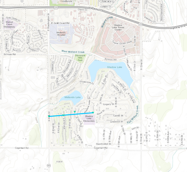
|
||||||||||||||||
|
||||||||||||||||
|
Bellevue Tornado
Track Map 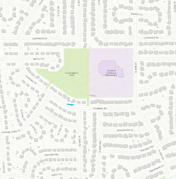
|
||||||||||||||||
|
||||||||||||||||
|
Old Towne Bellevue Tornado
Track Map 
|
||||||||||||||||
|
||||||||||||||||
|
South of Treynor Tornado
Track Map 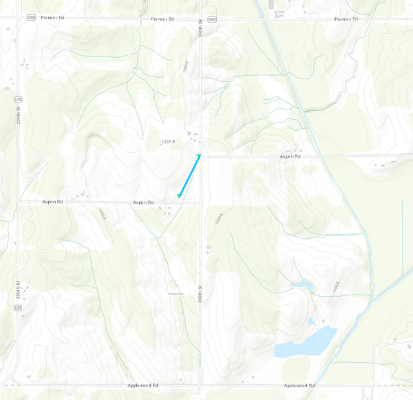
|
||||||||||||||||
|
||||||||||||||||
|
Henderson Tornado
Track Map 
|
||||||||||||||||
|
||||||||||||||||
|
Westphalia/Earling Tornado
Track Map 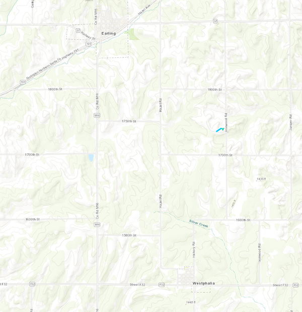
|
||||||||||||||||
|
||||||||||||||||
The Enhanced Fujita (EF) Scale classifies tornadoes into the following categories:
| EF0 Weak 65-85 mph |
EF1 Moderate 86-110 mph |
EF2 Significant 111-135 mph |
EF3 Severe 136-165 mph |
EF4 Extreme 166-200 mph |
EF5 Catastrophic 200+ mph |
 |
|||||
Wind & Hail:
Add a written summary or simply an LSR map in this section. If writing an extensive report, you can break the report down into wind and hail below (otherwise delete).
Wind
Insert summary here.
| Caption | Caption | Caption | Caption |
Photos & Video
Header
| Caption (source) |
Caption (source) |
Caption (source) |
Caption (source) |
Radar
Header
| Caption | Caption | Caption | Caption |
Storm Reports
..TIME... ...EVENT... ...CITY LOCATION... ...LAT.LON...
..DATE... ....MAG.... ..COUNTY LOCATION..ST.. ...SOURCE....
..REMARKS..
1214 AM Tstm Wnd Gst 4 E Albion 41.70N 97.93W
05/24/2024 M66 MPH Boone NE Public
Personal weather station.
1251 AM Tstm Wnd Gst 1 NE Columbus 41.45N 97.34W
05/24/2024 M61 MPH Platte NE ASOS
KOLU ASOS.
0117 AM Tstm Wnd Gst 3 WSW Richland 41.42N 97.27W
05/24/2024 M58 MPH Platte NE Public
Measured wind gust from a personal weather
station of 58 mph.
0137 AM Tstm Wnd Gst 5 SSW Howells 41.65N 97.03W
05/24/2024 M60 MPH Colfax NE Public
Personal weather station measured a 60 mph
wind gust.
0141 AM Tornado 6 SSW Dodge 41.64N 96.92W
05/24/2024 Colfax NE NWS Employee
TDS observed approximately 7 miles
south-southwest of Dodge.
0141 AM Tornado 6 SSW Dodge 41.64N 96.92W
05/24/2024 Colfax NE NWS Employee
TDS observed approximately 7 miles
south-southwest of Dodge.
0141 AM Tstm Wnd Dmg 2 S Utica 40.87N 97.34W
05/24/2024 Seward NE Public
Several branches down and trees snapped.
0141 AM Tstm Wnd Dmg 2 S Utica 40.87N 97.34W
05/24/2024 Seward NE Public
Several branches down and trees snapped.
0145 AM Tstm Wnd Gst 4 N Milford 40.83N 97.06W
05/24/2024 M66 MPH Seward NE Public
66 mph wind gust measured by NDOT station
E0651.
0150 AM Funnel Cloud Snyder 41.70N 96.79W
05/24/2024 Dodge NE Fire Dept/Rescue
Snyder Fire Department reported a funnel
cloud that passed over the top of the town.
Time estimated by radar.
0150 AM Funnel Cloud Snyder 41.70N 96.79W
05/24/2024 Dodge NE Fire Dept/Rescue
Snyder Fire Department reported a funnel
cloud that passed over the top of the town.
Time estimated by radar.
0152 AM Tornado 2 NW Scribner 41.69N 96.69W
05/24/2024 Dodge NE Fire Dept/Rescue
tornado reported.
0152 AM Tornado 2 NW Scribner 41.69N 96.69W
05/24/2024 Dodge NE Fire Dept/Rescue
tornado reported.
0154 AM Tornado 5 W Nickerson 41.54N 96.56W
05/24/2024 Dodge NE Trained Spotter
Trained spotter says a tornado is on the
ground.
0154 AM Tornado 5 W Nickerson 41.54N 96.56W
05/24/2024 Dodge NE Trained Spotter
Trained spotter says a tornado is on the
ground.
0156 AM Tstm Wnd Gst 3 ENE Pleasant Dale 40.81N 96.88W
05/24/2024 M60 MPH Lancaster NE Public
60 mph wind gust measured by a personal
weather station.
0157 AM Tstm Wnd Dmg Snyder 41.70N 96.79W
05/24/2024 Dodge NE Emergency Mngr
About a third of the town of Snyder lost
power as the storm moved through. Time
estimated by radar.
0157 AM Tstm Wnd Dmg Snyder 41.70N 96.79W
05/24/2024 Dodge NE Emergency Mngr
About a third of the town of Snyder lost
power as the storm moved through. Time
estimated by radar.
0200 AM Tstm Wnd Dmg 2 WNW Hooper 41.62N 96.58W
05/24/2024 Dodge NE Emergency Mngr
Microwave dishes were blown off a cell tower
between Hooper and Scribner. Time estimated
from radar.
0200 AM Tstm Wnd Dmg 2 WNW Hooper 41.62N 96.58W
05/24/2024 Dodge NE Emergency Mngr
Microwave dishes were blown off a cell tower
between Hooper and Scribner. Time estimated
from radar.
0200 AM Tstm Wnd Gst 8 NNE Western 40.50N 97.13W
05/24/2024 M63 MPH Saline NE Public
Personal weather station measured a 63 mph
wind gust.
0201 AM Tstm Wnd Gst 5 WSW Bancroft 41.97N 96.67W
05/24/2024 M69 MPH Cuming NE Public
Personal weather station recorded a 69 mph
wind gust.
0202 AM Tstm Wnd Gst 3 S Inglewood 41.38N 96.49W
05/24/2024 M66 MPH Saunders NE Public
66 mph wind gust measured by a personal
weather station.
0205 AM Tstm Wnd Dmg 1 NW Fremont 41.45N 96.52W
05/24/2024 Dodge NE NWS Employee
Several small limbs and branches down.
0205 AM Tstm Wnd Dmg 1 NW Fremont 41.45N 96.52W
05/24/2024 Dodge NE NWS Employee
Several small limbs and branches down.
0208 AM Tstm Wnd Dmg 1 NW Fremont 41.45N 96.51W
05/24/2024 Dodge NE NWS Employee
Large branch down.
0208 AM Tstm Wnd Dmg 1 NW Fremont 41.45N 96.51W
05/24/2024 Dodge NE NWS Employee
Large branch down.
0208 AM Tstm Wnd Gst 3 W Nickerson 41.54N 96.53W
05/24/2024 M67 MPH Dodge NE Public
personal weather station.
0210 AM Tstm Wnd Dmg Wilber 40.48N 96.96W
05/24/2024 Saline NE Public
shingles torn off of roof. Lots of tree
damage.
0210 AM Tstm Wnd Dmg Wilber 40.48N 96.96W
05/24/2024 Saline NE Public
shingles torn off of roof. Lots of tree
damage.
0211 AM Tstm Wnd Dmg 2 NW Fremont 41.46N 96.52W
05/24/2024 Dodge NE Public
Report from mPING: 3-inch tree limbs broken;
Power poles broken.
0211 AM Tstm Wnd Dmg 2 NW Fremont 41.46N 96.52W
05/24/2024 Dodge NE Public
Report from mPING: 3-inch tree limbs broken;
Power poles broken.
0212 AM Tstm Wnd Dmg 3 N Arlington 41.50N 96.36W
05/24/2024 Washington NE Public
Roof torn off of outbuilding.
0212 AM Tstm Wnd Dmg 3 N Arlington 41.50N 96.36W
05/24/2024 Washington NE Public
Roof torn off of outbuilding.
0212 AM Tstm Wnd Gst 1 SSW Fremont 41.43N 96.50W
05/24/2024 M61 MPH Dodge NE Amateur Radio
.
0213 AM Hail 3 NE Denton 40.78N 96.82W
05/24/2024 M1.00 Inch Lancaster NE Public
Report from mPING: Quarter (1.00 in.).
0214 AM Tstm Wnd Gst 3 SSE Inglewood 41.37N 96.49W
05/24/2024 M72 MPH Saunders NE Public
personal weather station.
0215 AM Tstm Wnd Gst 2 N Ashland 41.07N 96.38W
05/24/2024 M67 MPH Saunders NE Public
.
0217 AM Tstm Wnd Gst 7 NNE Arlington 41.55N 96.31W
05/24/2024 M64 MPH Washington NE Public
.
0220 AM Tstm Wnd Gst 4 S Cortland 40.45N 96.70W
05/24/2024 M68 MPH Gage NE Public
0223 AM Tstm Wnd Gst 1 SW Blair 41.53N 96.15W
05/24/2024 M67 MPH Washington NE Public
.
0225 AM Tstm Wnd Dmg 3 SE Gretna 41.12N 96.21W
05/24/2024 Sarpy NE Public
Numerous trees down on Capehart Rd between
192nd and 180th street.
0225 AM Tstm Wnd Dmg 3 SE Gretna 41.12N 96.21W
05/24/2024 Sarpy NE Public
Numerous trees down on Capehart Rd between
192nd and 180th street.
0226 AM Tstm Wnd Gst 1 SSE Blair 41.53N 96.13W
05/24/2024 M72 MPH Washington NE Public
personal weather station.
0226 AM Tstm Wnd Gst Louisville 41.00N 96.16W
05/24/2024 E70 MPH Cass NE Emergency Mngr
.
0226 AM Tstm Wnd Gst Macy 42.11N 96.36W
05/24/2024 E70 MPH Thurston NE Emergency Mngr
.
0227 AM Tstm Wnd Dmg 4 SE Bennington 41.32N 96.11W
05/24/2024 Douglas NE Public
Report from mPING: 1-inch tree limbs broken;
Shingles blown off.
0227 AM Tstm Wnd Dmg 2 SE Lincoln 40.79N 96.67W
05/24/2024 Lancaster NE Amateur Radio
Large tree down on Normal Boulevard, just
north of South Street.
0227 AM Tstm Wnd Dmg 2 SE Lincoln 40.79N 96.67W
05/24/2024 Lancaster NE Amateur Radio
Large tree down on Normal Boulevard, just
north of South Street.
0227 AM Tstm Wnd Dmg 4 SE Bennington 41.32N 96.11W
05/24/2024 Douglas NE Public
Report from mPING: 1-inch tree limbs broken;
Shingles blown off.
0228 AM Tstm Wnd Dmg Blair 41.54N 96.14W
05/24/2024 Washington NE Public
Numerous large branches down and trees
snapped.
0228 AM Tstm Wnd Dmg Blair 41.54N 96.14W
05/24/2024 Washington NE Public
Numerous large branches down and trees
snapped.
0234 AM Tstm Wnd Dmg 1 N Ashland 41.06N 96.37W
05/24/2024 Saunders NE Storm Chaser
Storm chaser reports widespread tree damage
with numerous branches down across Highway
66.
0234 AM Tstm Wnd Dmg 1 N Ashland 41.06N 96.37W
05/24/2024 Saunders NE Storm Chaser
Storm chaser reports widespread tree damage
with numerous branches down across Highway
66.
0234 AM Tstm Wnd Gst 6 S Fort Calhoun 41.37N 96.00W
05/24/2024 M63 MPH Douglas NE Public
0235 AM Tstm Wnd Dmg 2 W Offutt Afb 41.12N 95.96W
05/24/2024 Sarpy NE Public
Trees and branches down.
0235 AM Tstm Wnd Dmg 2 W Offutt Afb 41.12N 95.96W
05/24/2024 Sarpy NE Public
Trees and branches down.
0235 AM Tstm Wnd Gst 2 ESE Tekamah 41.76N 96.18W
05/24/2024 M62 MPH Burt NE ASOS
KTQE ASOS.
0238 AM Tstm Wnd Dmg 3 ESE Omaha 41.25N 95.96W
05/24/2024 Douglas NE Broadcast Media
Delayed report of powerlines down at Pacific
and 32nd. Time estimated by radar.
0238 AM Tstm Wnd Dmg 3 SE Omaha 41.23N 95.98W
05/24/2024 Douglas NE Public
large tree on house.
0238 AM Tstm Wnd Dmg 3 SE Omaha 41.23N 95.98W
05/24/2024 Douglas NE Public
large tree on house.
0238 AM Tstm Wnd Dmg 3 ESE Omaha 41.25N 95.96W
05/24/2024 Douglas NE Broadcast Media
Delayed report of powerlines down at Pacific
and 32nd. Time estimated by radar.
0238 AM Tstm Wnd Gst Missouri Valley 41.55N 95.90W
05/24/2024 M73 MPH Harrison IA Public
.
0240 AM Tstm Wnd Dmg 3 NE Elkhorn 41.31N 96.21W
05/24/2024 Douglas NE Public
Trees blown down.
0240 AM Tstm Wnd Dmg 3 NE Elkhorn 41.31N 96.21W
05/24/2024 Douglas NE Public
Trees blown down.
0240 AM Tstm Wnd Gst 3 SE Papillion 41.13N 95.99W
05/24/2024 M77 MPH Sarpy NE Public
.
0241 AM Tstm Wnd Gst 7 ENE Omaha 41.30N 95.89W
05/24/2024 M63 MPH Douglas NE ASOS
At Eppley Airfield.
0241 AM Tstm Wnd Gst 1 SSE Missouri Valley 41.54N 95.89W
05/24/2024 M71 MPH Harrison IA Public
71 mph wind gust measured out of the
Missouri Valley Airport.
0241 AM Tstm Wnd Gst 3 ESE Papillion 41.13N 95.99W
05/24/2024 M82 MPH Sarpy NE Public
personal weather station measurement.
0242 AM Tstm Wnd Dmg 4 SSW Offutt Afb 41.06N 95.95W
05/24/2024 Sarpy NE Public
large Tree uprooted.
0242 AM Tstm Wnd Dmg 4 SSW Offutt Afb 41.06N 95.95W
05/24/2024 Sarpy NE Public
large Tree uprooted.
0243 AM Tstm Wnd Gst Offutt Afb 41.11N 95.92W
05/24/2024 M68 MPH Sarpy NE AWOS
Approximately 10 minutes of severe wind
gusts reported at KOFF. Peak wind gust
measured at 68 mph.
0244 AM Tstm Wnd Gst 4 SE Lewiston 40.21N 96.35W
05/24/2024 M58 MPH Pawnee NE Trained Spotter
.
0245 AM Tstm Wnd Dmg 2 SW Papillion 41.13N 96.06W
05/24/2024 Sarpy NE Public
Siding torn from home.
0245 AM Tstm Wnd Dmg 3 SE Omaha 41.23N 95.98W
05/24/2024 Douglas NE Fire Dept/Rescue
Tree fell on a home.
0245 AM Tstm Wnd Dmg 2 SW Papillion 41.13N 96.06W
05/24/2024 Sarpy NE Public
Siding torn from home.
0245 AM Tstm Wnd Dmg 2 SW Bellevue 41.14N 95.96W
05/24/2024 Sarpy NE Public
Report from mPING: 1-inch tree limbs broken;
Shingles blown off.
0245 AM Tstm Wnd Dmg 3 SE Omaha 41.23N 95.98W
05/24/2024 Douglas NE Fire Dept/Rescue
Tree fell on a home.
0245 AM Tstm Wnd Dmg 2 SW Bellevue 41.14N 95.96W
05/24/2024 Sarpy NE Public
Report from mPING: 1-inch tree limbs broken;
Shingles blown off.
0245 AM Tstm Wnd Gst 4 ENE Missouri Valley 41.57N 95.82W
05/24/2024 M74 MPH Harrison IA Public
.
0246 AM Tstm Wnd Gst 6 West Castana 42.07N 96.05W
05/24/2024 M83 MPH Monona IA Public
From a personal weather station.
0247 AM Tstm Wnd Dmg Bellevue 41.16N 95.92W
05/24/2024 Sarpy NE Public
Several large branchees down.
0247 AM Tstm Wnd Dmg Bellevue 41.16N 95.92W
05/24/2024 Sarpy NE Public
Several large branchees down.
0248 AM Tstm Wnd Dmg 2 SE Sterling 40.43N 96.35W
05/24/2024 Johnson NE Public
Report from mPING: 1-inch tree limbs broken;
Shingles blown off.
0248 AM Tstm Wnd Dmg 3 SW Papillion 41.14N 96.08W
05/24/2024 Sarpy NE Public
Report from mPING: 1-inch tree limbs broken;
Shingles blown off.
0248 AM Tstm Wnd Dmg 2 SE Sterling 40.43N 96.35W
05/24/2024 Johnson NE Public
Report from mPING: 1-inch tree limbs broken;
Shingles blown off.
0248 AM Tstm Wnd Dmg 3 E Murray 40.93N 95.88W
05/24/2024 Cass NE Public
Report from mPING: 1-inch tree limbs broken;
Shingles blown off.
0248 AM Tstm Wnd Dmg 3 E Murray 40.93N 95.88W
05/24/2024 Cass NE Public
Report from mPING: 1-inch tree limbs broken;
Shingles blown off.
0248 AM Tstm Wnd Dmg 3 SW Papillion 41.14N 96.08W
05/24/2024 Sarpy NE Public
Report from mPING: 1-inch tree limbs broken;
Shingles blown off.
0249 AM Tstm Wnd Dmg 1 NW Glenwood 41.06N 95.76W
05/24/2024 Mills IA Public
Report from mPING: 1-inch tree limbs broken;
Shingles blown off.
0249 AM Tstm Wnd Dmg 2 NE Ralston 41.23N 96.02W
05/24/2024 Douglas NE Public
Report from mPING: 1-inch tree limbs broken;
Shingles blown off.
0249 AM Tstm Wnd Dmg 1 NW Glenwood 41.06N 95.76W
05/24/2024 Mills IA Public
Report from mPING: 1-inch tree limbs broken;
Shingles blown off.
0249 AM Tstm Wnd Dmg 2 NE Ralston 41.23N 96.02W
05/24/2024 Douglas NE Public
Report from mPING: 1-inch tree limbs broken;
Shingles blown off.
0251 AM Tstm Wnd Gst 1 WNW Glenwood 41.05N 95.75W
05/24/2024 E60 MPH Mills IA Law Enforcement
Law enforcement estimates 60 mph winds
coming into the city of Glenwood.
0252 AM Tstm Wnd Gst 5 WNW Persia 41.60N 95.66W
05/24/2024 M58 MPH Harrison IA Public
.
0257 AM Tstm Wnd Dmg 5 NNW Pacific Junction 41.08N 95.83W
05/24/2024 Mills IA Emergency Mngr
Emergency Management reported an overturned
semi at the southbound rest area on I-29 in
Mills County.
0257 AM Tstm Wnd Dmg 5 NNW Pacific Junction 41.08N 95.83W
05/24/2024 Mills IA Emergency Mngr
Emergency Management reported an overturned
semi at the southbound rest area on I-29 in
Mills County.
0300 AM Tstm Wnd Gst 2 SSE Silver City 41.08N 95.62W
05/24/2024 M59 MPH Mills IA Public
From a personal weather station.
0304 AM Tstm Wnd Gst 5 SE Treynor 41.18N 95.53W
05/24/2024 M67 MPH Pottawattamie IA Public
0306 AM Tstm Wnd Gst 5 WNW Henderson 41.16N 95.53W
05/24/2024 M62 MPH Pottawattamie IA Public
.
0307 AM Tstm Wnd Dmg 5 W Portsmouth 41.65N 95.62W
05/24/2024 Harrison IA Amateur Radio
Tree blown down with several other trees
with broken branches.
0307 AM Tstm Wnd Dmg 5 W Portsmouth 41.65N 95.62W
05/24/2024 Harrison IA Amateur Radio
Tree blown down with several other trees
with broken branches.
0310 AM Tstm Wnd Dmg Henderson 41.14N 95.43W
05/24/2024 Mills IA Emergency Mngr
Delayed report from Emergency Management of
downed powerlines and limbs down on cars in
Henderson. Time estimated from radar.
0310 AM Tstm Wnd Dmg Henderson 41.14N 95.43W
05/24/2024 Mills IA Emergency Mngr
Delayed report from Emergency Management of
downed powerlines and limbs down on cars in
Henderson. Time estimated from radar.
0312 AM Tstm Wnd Gst Harlan 41.65N 95.32W
05/24/2024 M60 MPH Shelby IA Public
Personal weather station.
0312 AM Tstm Wnd Gst 1 NW Harlan 41.66N 95.34W
05/24/2024 M60 MPH Shelby IA Public
.
0315 AM Tstm Wnd Dmg Harlan 41.65N 95.33W
05/24/2024 Shelby IA Public
Delayed report. Photos of large tree that
fell onto a house leading to holes in the
roof and walls.
0315 AM Tstm Wnd Dmg Harlan 41.65N 95.33W
05/24/2024 Shelby IA Public
Delayed report. Photos of large tree that
fell onto a house leading to holes in the
roof and walls.
0315 AM Tstm Wnd Gst 2 E Harlan 41.65N 95.28W
05/24/2024 M64 MPH Shelby IA Public
0319 AM Tstm Wnd Gst 7 NE Emerson 41.09N 95.32W
05/24/2024 M69 MPH Montgomery IA Public
0321 AM Tstm Wnd Gst 2 SW Kirkman 41.71N 95.29W
05/24/2024 M65 MPH Shelby IA Public
0326 AM Tstm Wnd Gst 2 W Elliott 41.14N 95.20W
05/24/2024 M58 MPH Montgomery IA Public
.
0330 AM Tstm Wnd Dmg Elliott 41.15N 95.16W
05/24/2024 Montgomery IA Emergency Mngr
Emergency Manager reported the city of
Elliot has lost power.
0330 AM Tstm Wnd Dmg Elliott 41.15N 95.16W
05/24/2024 Montgomery IA Emergency Mngr
Emergency Manager reported the city of
Elliot has lost power.
0331 AM Tstm Wnd Gst 2 SW Brownville 40.38N 95.68W
05/24/2024 M58 MPH Nemaha NE Public
0337 AM Tstm Wnd Gst Villisca 40.93N 94.98W
05/24/2024 M67 MPH Montgomery IA Public
.
&&
$$
Environment
Insert synoptic summary.
| Figure 1: Caption | Figure 2: Caption | Figure 3: Caption |
Near-storm environment summary.
| Figure 4: Caption | Figure 5: Caption | Figure 6: Caption |
Additional environmental data.
| Figure 7: Caption | Figure 8: Caption | Figure 9: Caption |
Additional Information
The Forecast
 |
 |
| SPC Day 7 Probabilistic Outlook | SPC Day 6 Probabilistic Outlook |
 |
 |
| SPC Day 5 Probabilistic Outlook | SPC Day 4 Probabilistic Outlook |
 |
 |
| SPC Day 3 Categorical Outlook | SPC Day 3 Probabilistic Outlook |
 |
 |
 |
 |
| SPC Day 2 Categorical Outlook | SPC Day 2 Tornado Outlook | SPC Day 2 Hail Outlook | SPC Day 2 Wind Outlook |
 |
 |
 |
 |
| SPC Day 1 Categorical Outlook | SPC Day 1 Tornado Outlook | SPC Day 1 Hail Outlook | SPC Day 1 Wind Outlook |
Summaries from other NWS Offices
 |
Media use of NWS Web News Stories is encouraged! Please acknowledge the NWS as the source of any news information accessed from this site. |
|

