Dangerous and extreme heat will remain across portions of the southern U.S. through the weekend. A heat wave over the Southwest U.S. will intensify this week, peaking and expanding into the Intermountain West and northern High Plains this weekend. Multiple rounds of thunderstorms will produce heavy to excessive rainfall with significant flash flooding across portions of southern New England. Read More >
|
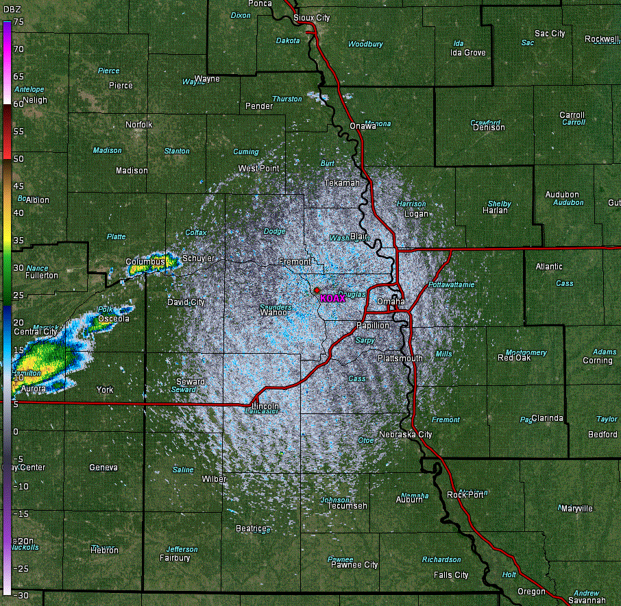
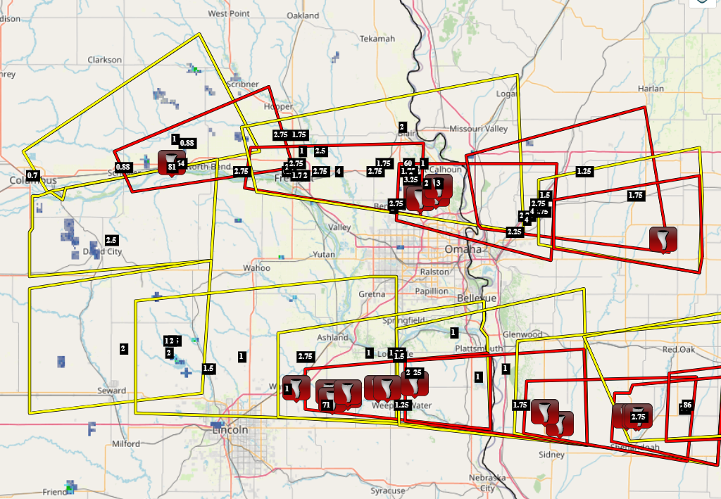
Overview Two powerful, long-lived supercells tracked across eastern Nebraska and southwest Iowa during the afternoon and evening hours |
 |
Tornadoes:
|
Tornado - Bennington/Ft. Calhoun, NE
|
||||||||||||||||
|
||||||||||||||||
|
Tornado - Alvo, NE (Cass County #1)
|
||||||||||||||||
|
Tornado - Murdock, NE (Cass County #2)
Track Map 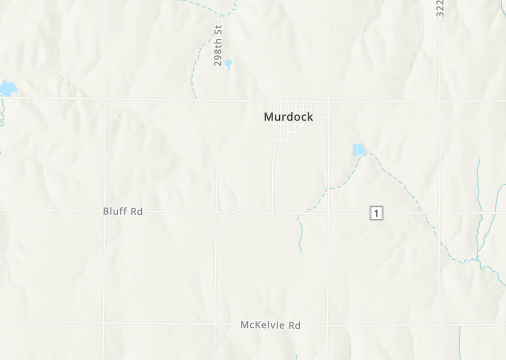  |
||||||||||||||||
|
Tornado - Manley, NE (Cass County #3)
|
||||||||||||||||
|
Tornado - Tabor, IA
|
||||||||||||||||
|
||||||||||||||||
|
Tornado - Imogene and Essex, IA
|
||||||||||||||||
|
||||||||||||||||
The Enhanced Fujita (EF) Scale classifies tornadoes into the following categories:
| EF0 Weak 65-85 mph |
EF1 Moderate 86-110 mph |
EF2 Significant 111-135 mph |
EF3 Severe 136-165 mph |
EF4 Extreme 166-200 mph |
EF5 Catastrophic 200+ mph |
 |
|||||
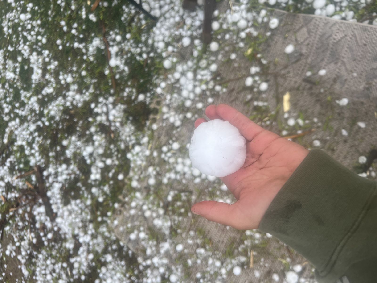
Wind & Hail:
The two supercells were prodigious hail-producers with hail up to softball-size (4" in diameter) reported. In some locations like Fremont, NE, the hail was driven by winds up to 70 mph, with considerable exterior damage to many buildings and homes.
Wind
Insert summary here.
| Caption | Caption | Caption | Caption |
Hail
Insert summary here.
 |
 |
||
| Caption | Caption | Caption | Caption |
Photos & Video
Header
| Caption (source) |
Caption (source) |
Caption (source) |
Caption (source) |
Radar
Header
| Caption | Caption | Caption | Caption |
Storm Reports
..TIME... ...EVENT... ...CITY LOCATION... ...LAT.LON...
..DATE... ....MAG.... ..COUNTY LOCATION..ST.. ...SOURCE....
..REMARKS..
0511 PM Hail 2 S Fort Calhoun 41.42N 96.02W
04/17/2025 M3.00 Inch Washington NE Storm Chaser
delayed report.
0608 PM Hail 2 SW Kennard 41.45N 96.23W
04/17/2025 E2.75 Inch Washington NE Public
0630 PM Hail Arlington 41.45N 96.35W
04/17/2025 E4.00 Inch Washington NE Public
0634 PM Hail 4 NW Arlington 41.50N 96.41W
04/17/2025 M2.50 Inch Washington NE Public
0639 PM Hail Kennard 41.47N 96.20W
04/17/2025 M1.75 Inch Washington NE Trained Spotter
0649 PM Hail 3 W Fort Calhoun 41.47N 96.07W
04/17/2025 M1.00 Inch Washington NE Public
Report from mPING: Quarter (1.00 in.).
0650 PM Hail 4 WSW Fort Calhoun 41.44N 96.11W
04/17/2025 E2.00 Inch Washington NE Public
0652 PM Hail 4 E Kennard 41.45N 96.12W
04/17/2025 E1.75 Inch Washington NE Public
Report from mPING: Golf Ball (1.75 in.).
0653 PM Hail 3 W Fort Calhoun 41.47N 96.07W
04/17/2025 E1.00 Inch Washington NE Public
Report from mPING: Quarter (1.00 in.).
0655 PM Tstm Wnd Gst 4 E Kennard 41.47N 96.12W
04/17/2025 M60 MPH Washington NE Public
0705 PM Hail 1 N Blair 41.56N 96.14W
04/17/2025 M2.00 Inch Washington NE Amateur Radio
0706 PM Tornado 3 S Fort Calhoun 41.41N 96.02W
04/17/2025 Washington NE Trained Spotter
0707 PM Hail 5 NNE Bennington 41.43N 96.11W
04/17/2025 M3.25 Inch Washington NE Public
0713 PM Hail 3 SW Fort Calhoun 41.42N 96.06W
04/17/2025 E2.00 Inch Washington NE Public
Report from mPING: Hen Egg (2.00 in.).
0741 PM Tornado 4 S Fort Calhoun 41.39N 96.03W
04/17/2025 Washington NE Public
Damage reported via Omaha Scanner on Social
Media.
0627 PM Hail Bee 41.01N 97.06W
04/17/2025 E2.00 Inch Seward NE Public
0515 PM Hail 1 NW Columbus 41.44N 97.36W
04/17/2025 M0.70 Inch Platte NE Emergency Mngr
0630 PM Hail 6 NE Garland 41.00N 96.91W
04/17/2025 E2.00 Inch Lancaster NE Public
0635 PM Hail 5 SW Valparaiso 41.03N 96.90W
04/17/2025 M2.00 Inch Lancaster NE Trained Spotter
Corrects previous hail report from 5 SW
Valparaiso that originally said 1.75 inches.
0638 PM Hail Raymond 40.96N 96.78W
04/17/2025 E1.00 Inch Lancaster NE Public
0645 PM Hail Raymond 40.96N 96.78W
04/17/2025 E1.50 Inch Lancaster NE NWS Employee
0648 PM Hail Davey 40.99N 96.67W
04/17/2025 E1.00 Inch Lancaster NE NWS Employee
0658 PM Hail 1 E Waverly 40.91N 96.52W
04/17/2025 E1.00 Inch Lancaster NE Public
Report from mPING: Quarter (1.00 in.).
0724 PM Tornado 2 E Waverly 40.91N 96.49W
04/17/2025 Lancaster NE Storm Chaser
Report relayed via social media.
0650 PM Hail 1 SW Bennington 41.36N 96.17W
04/17/2025 E1.00 Inch Douglas NE Public
0652 PM Hail Bennington 41.37N 96.16W
04/17/2025 M2.75 Inch Douglas NE Public
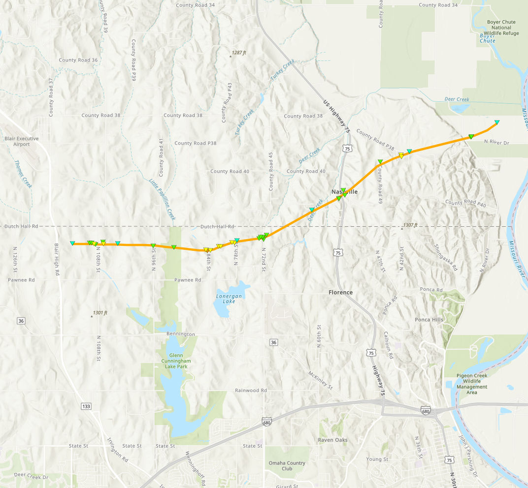
0655 PM Tornado 4 ENE Bennington 41.39N 96.09W
04/17/2025 Douglas NE NWS Storm Survey
At approximately 6:55 PM CDT on Thursday,
April 17, a tornado developed near Highway
133, and appeared to produce first damage by
snapping limbs in an area of trees. The
tornado moved to the east, impacting trees,
homes, and destroying a garage near 108th
Street. It damaged trees along Little
Papillion Creek and then impacted a home and
large garage near 84th Street, south of
Dutch Hall Road. This was the point along
the tornado track where the most intense
damage was observed, as a well-built
all-brick home was destroyed with only some
walls still standing. Tree damage near the
site, as well as the destruction of a large,
well-built garage, supported the estimate of
high-end EF-2 to low-end EF-3 damage at this
location. The tornado proceeded to destroy
another large shed, and remove the roof from
a brick home a half mile to the east. It
then destroyed a very large garage-type
building in-between two homes at 78th Street
south of Dutch Hall Road. The tornado passed
directly between the homes, causing
extensive tree damage, lifting and moving a
full-size pickup truck approximately 30
yards, and throwing large trees nearly a
quarter of a mile downstream. The tornado
weakened slightly but damaged several
outbuildings and trees near 72nd Street. At
that point, it began to move more
northeasterly, snapping several trees and
flipping recreational vehicles at Nashville,
NE. It directly impacted another home,
destroying two outbuildings and causing tree
damage near Country Road P38. The tornado
impacted one more home and destroyed another
outbuilding near Country Road P51 before
dissipating in an open field at
approximately 7:15 PM CDT. The tornado is an
EF-3 with estimated maximum wind speeds
based on damage of 140 mph. The maximum
track width was approximately 170 yards and
the track length approximately 8.3 miles.
0659 PM Tornado 4 ENE Bennington 41.38N 96.08W
04/17/2025 Douglas NE Trained Spotter
0713 PM Hail 1 SW Bennington 41.36N 96.17W
04/17/2025 E2.00 Inch Douglas NE Public
Report from mPING: Hen Egg (2.00 in.).
0741 PM Tornado 4 ENE Bennington 41.38N 96.08W
04/17/2025 Douglas NE Public
Report of damage via Omaha Scanner on Social
Media.
0547 PM Hail 5 NE Rogers 41.53N 96.89W
04/17/2025 E1.00 Inch Dodge NE Public
0553 PM Tornado 1 ENE Rogers 41.47N 96.90W
04/17/2025 Dodge NE Trained Spotter
Brief tornado may have occurred. Lots of
dust with a weak circulation.
0558 PM Tstm Wnd Gst 1 E Rogers 41.46N 96.90W
04/17/2025 M81 MPH Dodge NE Trained Spotter
0559 PM Tstm Wnd Gst 3 E Rogers 41.47N 96.87W
04/17/2025 M64 MPH Dodge NE Public
personal weather station.
0614 PM Hail 5 NE Rogers 41.52N 96.85W
04/17/2025 E0.88 Inch Dodge NE Public
Nickel-size hail.
0620 PM Hail 2 W Ames 41.45N 96.67W
04/17/2025 E2.75 Inch Dodge NE Emergency Mngr
Mix of golfball and baseball-size hail.
0621 PM Hail 2 NW Fremont 41.46N 96.52W
04/17/2025 E2.00 Inch Dodge NE Public
Report from mPING: Hen Egg (2.00 in.).
0621 PM Hail 4 W Nickerson 41.54N 96.54W
04/17/2025 E2.75 Inch Dodge NE Public
Report from mPING: Baseball (2.75 in.).
0624 PM Tstm Wnd Gst 1 WNW Fremont 41.45N 96.52W
04/17/2025 M67 MPH Dodge NE AWOS
Fremont Airport.
0625 PM Hail 2 N Fremont 41.47N 96.49W
04/17/2025 E2.75 Inch Dodge NE NWS Employee
Windows broken by baseball-size hail 2 miles
N of Fremont.
0625 PM Tstm Wnd Gst 1 WNW Fremont 41.45N 96.51W
04/17/2025 M82 MPH Dodge NE Trained Spotter
0626 PM Hail 1 ENE Fremont 41.44N 96.48W
04/17/2025 M1.75 Inch Dodge NE Emergency Mngr
0627 PM Hail 2 E Fremont 41.44N 96.46W
04/17/2025 E2.00 Inch Dodge NE Public
Report from mPING: Hen Egg (2.00 in.).
0627 PM Hail 2 E Fremont 41.44N 96.46W
04/17/2025 E2.00 Inch Dodge NE Public
0628 PM Hail 3 W Arlington 41.45N 96.41W
04/17/2025 M2.75 Inch Dodge NE Public
Report from mPING: Baseball (2.75 in.).
0634 PM Hail Nickerson 41.54N 96.48W
04/17/2025 E1.75 Inch Dodge NE Fire Dept/Rescue
0643 PM Hail 2 S Nickerson 41.50N 96.47W
04/17/2025 E1.00 Inch Dodge NE Public
0543 PM Hail 1 N Schuyler 41.46N 97.06W
04/17/2025 E0.88 Inch Colfax NE Public
0700 PM Hail 2 NNW Greenwood 40.99N 96.46W
04/17/2025 M1.75 Inch Cass NE Emergency Mngr
0706 PM Hail 2 NNW Greenwood 40.99N 96.46W
04/17/2025 E2.75 Inch Cass NE Emergency Mngr
0713 PM Tstm Wnd Gst Alvo 40.87N 96.39W
04/17/2025 M71 MPH Cass NE Public
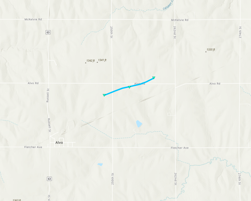
0714 PM Tornado 1 NE Alvo 40.88N 96.37W
04/17/2025 Cass NE NWS Storm Survey
Review of video evidence indicates that a
tornado tracked for approximately 2 minutes
with a maximum width of around 50 yards. It
tracked through open fields and a few wooded
areas, producing little to no damage, just
to small limbs and leaves. This was an EF-0
tornado with maximum winds estimated at 60
mph.
0715 PM Tornado 2 N Alvo 40.90N 96.38W
04/17/2025 Cass NE Trained Spotter
Approximate location of tornado viewed on
live feed.
0720 PM Tornado 3 SW Murdock 40.89N 96.32W
04/17/2025 Cass NE NWS Storm Survey
A review of video evidence confirms that an
intermittent tornado tracked near this
location for approximately 2 to 3 minutes,
passing through open fields. This tornado is
rated an EF-U as it did not impact any
potential damage indicators.
0722 PM Tornado 3 SW Murdock 40.90N 96.32W
04/17/2025 Cass NE Emergency Mngr
0725 PM Hail Louisville 40.99N 96.15W
04/17/2025 E1.00 Inch Cass NE Public
0728 PM Hail South Bend 41.00N 96.25W
04/17/2025 E1.00 Inch Cass NE Trained Spotter
0735 PM Hail Weeping Water 40.87N 96.14W
04/17/2025 M1.25 Inch Cass NE Public
0736 PM Hail 4 NE Manley 40.95N 96.10W
04/17/2025 E1.00 Inch Cass NE Public
Report from mPING: Quarter (1.00 in.).
0736 PM Tornado 3 WSW Manley 40.91N 96.22W
04/17/2025 Cass NE NWS Storm Survey
A review of video evidence indicates that an
intermittent tornado tracked off-and-on for
approximately 5 minutes, approaching but not
reaching the town of Manley. The tornado
passed mainly through open fields, but did
also pass through some areas of trees with
little to no damage. This has been rated an
EF-0 tornado with peak winds of
approximately 50 mph.
0738 PM Hail 4 NE Manley 40.95N 96.10W
04/17/2025 E1.00 Inch Cass NE Public
Report from mPING: Quarter (1.00 in.).
0739 PM Hail 4 NE Manley 40.95N 96.10W
04/17/2025 E1.25 Inch Cass NE Public
Report from mPING: Half Dollar (1.25 in.).
0740 PM Hail 3 NE Manley 40.95N 96.12W
04/17/2025 M2.00 Inch Cass NE Trained Spotter
Delayed report.
0741 PM Tornado 1 WSW Manley 40.91N 96.19W
04/17/2025 Cass NE Emergency Mngr
0741 PM Hail Louisville 40.99N 96.15W
04/17/2025 E1.50 Inch Cass NE Public
Report from mPING: Ping Pong Ball (1.50
in.).
0744 PM Hail 2 NE Murray 40.94N 95.89W
04/17/2025 M1.00 Inch Cass NE Public
0750 PM Hail Louisville 41.00N 96.16W
04/17/2025 M1.25 Inch Cass NE Public
0753 PM Tornado 3 E Manley 40.92N 96.10W
04/17/2025 Cass NE Emergency Mngr
Tornado impacting residence.
0754 PM Hail 5 SW Offutt Afb 41.05N 95.97W
04/17/2025 E1.00 Inch Cass NE Public
Report from mPING: Quarter (1.00 in.).
0556 PM Hail 2 NE David City 41.28N 97.10W
04/17/2025 E2.50 Inch Butler NE Public
Time estimated from radar. Actual
measurement was 2.4.
0724 PM Hail 5 WSW Mcclelland 41.30N 95.77W
04/17/2025 M2.25 Inch Pottawattamie IA Broadcast Media
0728 PM Hail 1 NE Underwood 41.39N 95.67W
04/17/2025 M1.50 Inch Pottawattamie IA Emergency Mngr
0729 PM Hail 4 SSW Underwood 41.37N 95.69W
04/17/2025 E2.75 Inch Pottawattamie IA Public
0731 PM Hail 3 WNW Mcclelland 41.34N 95.73W
04/17/2025 E2.75 Inch Pottawattamie IA Law Enforcement
0737 PM Hail 2 N Mcclelland 41.35N 95.68W
04/17/2025 M2.75 Inch Pottawattamie IA Trained Spotter
0738 PM Hail 2 SSE Minden 41.45N 95.54W
04/17/2025 E1.25 Inch Pottawattamie IA Emergency Mngr
0739 PM Hail 3 W Mcclelland 41.33N 95.73W
04/17/2025 E4.00 Inch Pottawattamie IA Public
0744 PM Hail 2 NW Mcclelland 41.35N 95.71W
04/17/2025 E4.00 Inch Pottawattamie IA Public
0808 PM Hail Hancock 41.39N 95.37W
04/17/2025 M1.75 Inch Pottawattamie IA Emergency Mngr
0832 PM Tornado 6 ESE Oakland 41.28N 95.28W
04/17/2025 Pottawattamie IA Trained Spotter
Possible report of a tornado between
Griswold and Oakland, from trained spotter.
0848 PM Tornado 4 W Essex 40.84N 95.37W
04/17/2025 Page IA Trained Spotter
Corrects previous tornado report from 4 W
Essex. Power poles snapped, trees and shed
material strewn over roadway. Time estimated
from radar.
0850 PM Tornado 3 WNW Essex 40.84N 95.36W
04/17/2025 Page IA Emergency Mngr
Tornado reported at Pierce Creek Recreation
Area.
0850 PM Hail 3 WNW Essex 40.84N 95.36W
04/17/2025 E2.75 Inch Page IA Emergency Mngr
Golf ball to baseball size hail reported.
0904 PM Tstm Wnd Gst 5 SE Coburg 40.87N 95.20W
04/17/2025 M86 MPH Page IA Public
Personal weather station measured wind gust
of 86 mph. Radar indicates the measurement
was likely in the RFD.
0909 PM Tstm Wnd Gst 5 E Essex 40.86N 95.21W
04/17/2025 M74 MPH Page IA Public
Measured with a personal weather station.
0751 PM Hail 4 S Pacific Junction 40.96N 95.80W
04/17/2025 E1.00 Inch Mills IA Public
Report from mPING: Quarter (1.00 in.).
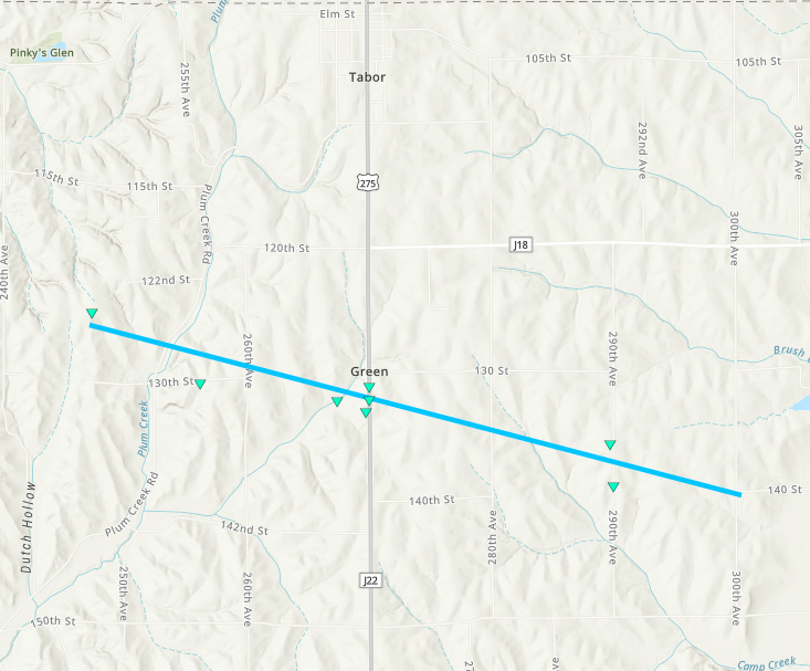
0813 PM Tornado 3 SW Tabor 40.86N 95.71W
04/17/2025 Fremont IA NWS Storm Survey
Approximately 8:13 pm CDT on Thursday, April
17, 2025, a tornado formed 3 miles southwest
of Tabor. The tornado stirred up copious
amounts of dust and dirt from recently
plowed agricultural field. The tornado moved
southeast across mainly agricultural fields
until cross U.S. 275, producing EF-0 damage
to roofs and farm outbuildings just south of
130th Street, reaching a width of about 1/4
mile. Based on video, the tornado weakened
briefly east of U.S. 275 until it crossed
280th Avenue, where it again reached a width
of about 1/4 mile and strengthened again
before crossing 290th Avenue, producing EF-0
damage to trees and flipping irrigation
pivots. The tornado continued until about
the intersection of 300th Avenue and 140th
Street where it dissipated at approximately
8:28 pm CDT.
0816 PM Hail 4 N Thurman 40.87N 95.75W
04/17/2025 E1.75 Inch Fremont IA Trained Spotter
0821 PM Tornado 3 S Tabor 40.85N 95.67W
04/17/2025 Fremont IA Storm Chaser
0827 PM Tornado 5 SW Randolph 40.82N 95.62W
04/17/2025 Fremont IA Storm Chaser
Live video feed and TDS confirm tornado.
0832 PM Tornado 2 SE Randolph 40.85N 95.54W
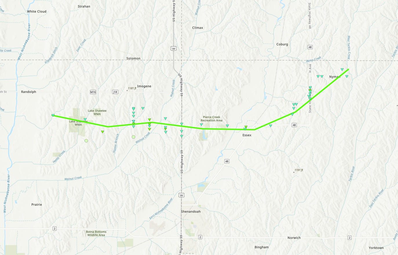
04/17/2025 Fremont IA NWS Storm Survey
At approximately 8:32 PM CDT, a tornado
formed southeast of Randolph, IA. The first
sign of damage was snapped tree limbs near
Lake Shawtee. As the tornado progressed
eastward, continued tree damage was observed
along with the damage of small outdoor farm
buildings and house roofs. A concentrated
area of the most extensive damage was
observed south of Imogene, IA. In this area,
damage included snapped wooden power poles,
minor damage to homes, and the continued
damage of outdoor buildings and trees. The
width of damage also reached its peak,
approximately 3130.6 yards in this area. The
tornado tracked just north of Essex, IA,
with more wooden power poles snapped and
farm outdoor building damage. After sliding
north of Essex, IA, the tornado tracked
northeast towards Nyman, IA. Similar damage,
including trees, outdoor buildings, and
wooden power poles were observed along this
stretch. The tornado lifted just east at
Nyman, IA at approximately 9:08 PM CDT. The
track length of the tornado was
approximately 19.7 miles, with a maximum
wind speed of 110 mph classifying it as an
EF1.
0846 PM Tornado 3 SSE Imogene 40.84N 95.40W
04/17/2025 Fremont IA Storm Chaser
Multiple trees down along 410th Ave, likely
from a tornado track.
Environment
Insert synoptic summary.
 |
 |
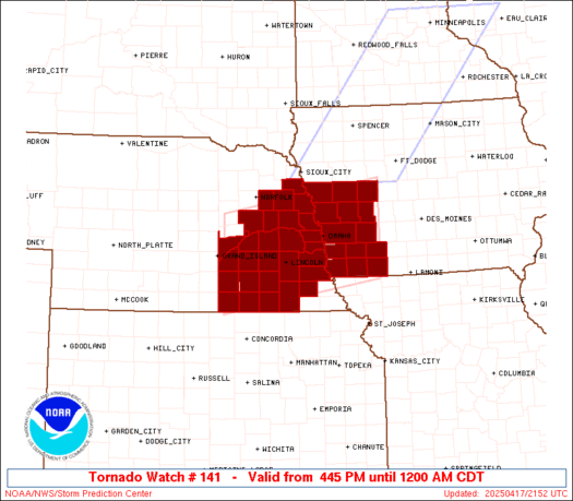 |
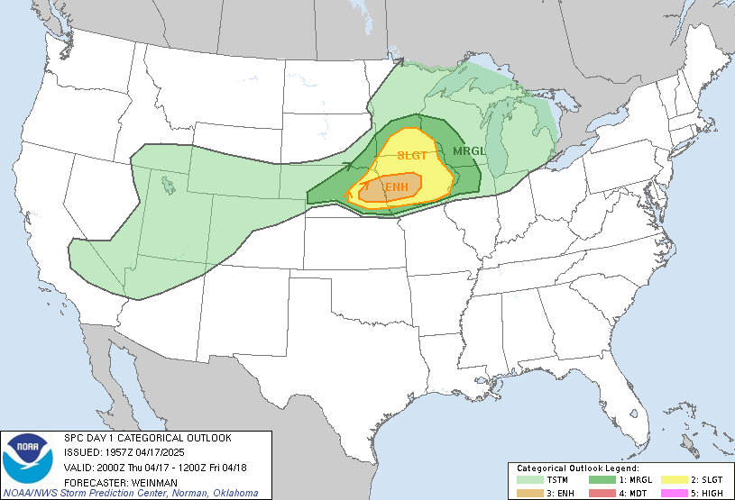
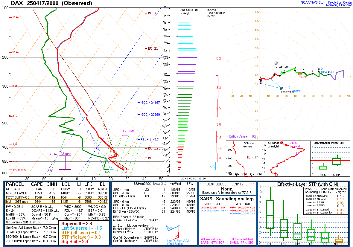
| Day 1 Convective Outlook issued 4/17/2025 at 20z | Figure 2: KOAX Upper Air Sounding 4/17/2025 at 20z | Figure 3: Tornado Watch issued 4/17/2025 at 2145Z |
Near-storm environment summary.
 |
 |
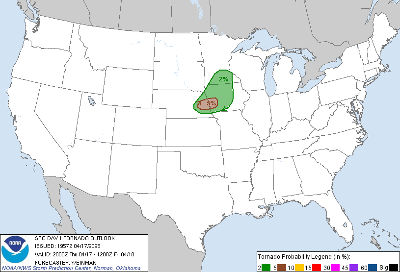 |
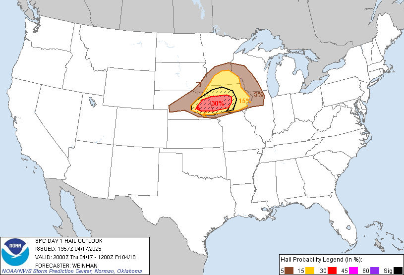
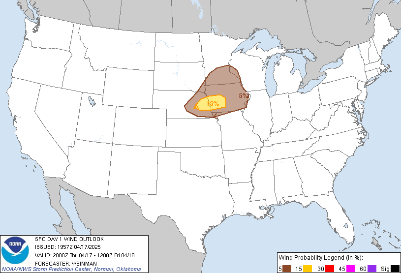
| Figure 4: Day 1 severe hail outlook issued 4/17/2025 at 20z | Figure 5: Day 1 severe wind outlook issued 4/17/2025 at 20z | Figure 6: Day 1 tornado outlook issued 4/17/2025 at 20z |
Additional environmental data.
| Figure 7: Caption | Figure 8: Caption | Figure 9: Caption |
 |
Media use of NWS Web News Stories is encouraged! Please acknowledge the NWS as the source of any news information accessed from this site. |
|