
Showers, along with a few strong to severe thunderstorms, are expected from the Great Lakes, New England and southward into the Ohio and Tennessee Valleys. In the wake of this system, a stronger storm is expected to track from the Pacific Northwest, Plains and through the Eastern U.S. this weekend. Strong winds, showers and a larger drop in temperatures are expected this weekend into Monday. Read More >
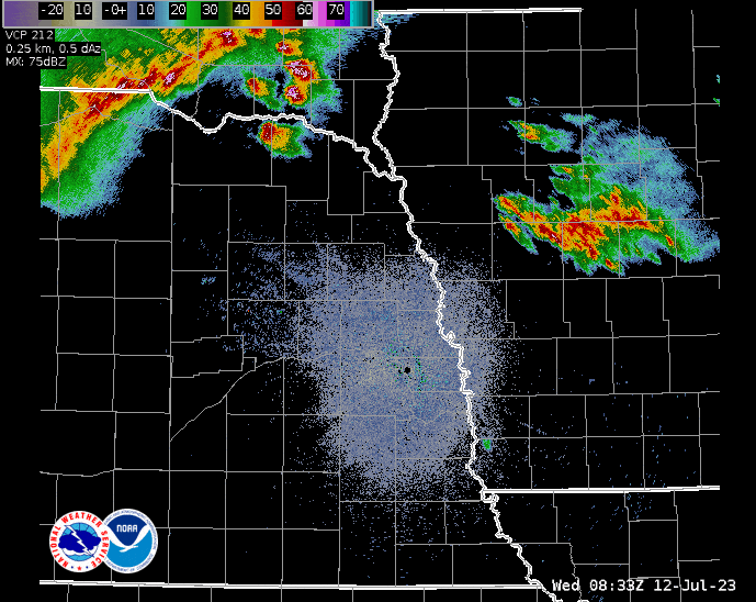
A line of strong thunderstorms moved through the region during the early morning hours on
Wednesday, July 12, 2023. The storms entered northeast NE around 4am and exited
southwest IA around 730 am. The storms produced widespread wind gusts of 60 to 82 mph
and produced a lot of tree and power line damage. Tens of thousands of people were
without power during the peak of the storms.
Chronological Listing of Storms Reports Issued
..TIME...   ...EVENT...      ...CITY LOCATION...     ...LAT.LON...
..DATE...   ....MAG....      ..COUNTY LOCATION..ST.. ...SOURCE....
            ..REMARKS..

0344 AM     Tstm Wnd Gst     2 ENE Verdel            42.83N 98.15W
07/12/2023  M57 MPH          Knox               NE   Public

            Measured by personal weather station.

0415 AM     Tstm Wnd Gst     2 SSE Creighton         42.44N 97.90W
07/12/2023  M66 MPH          Knox               NE   Public

            Measured from personal weather station.

0445 AM     Tstm Wnd Gst     8 SSW Sholes            42.23N 97.37W
07/12/2023  M63 MPH          Wayne              NE   Public

            From a personal weather station.

0451 AM     Tstm Wnd Gst     3 SSW Norfolk           41.99N 97.43W
07/12/2023  M64 MPH          Madison            NE   ASOS

            Measured at KOFK ASOS.

0459 AM     Tstm Wnd Dmg     Wayne                   42.24N 97.02W
07/12/2023                   Wayne              NE   Public

            Lots of damage to large trees throughout the
            city.

0500 AM     Tstm Wnd Dmg     Stanton                 41.95N 97.22W
07/12/2023                   Stanton            NE   Law Enforcement

            Corrects time to 5am estimated by radar.
            Tstm wnd dmg report from Stanton. tree down
            on house... no injuries.

0506 AM     Tstm Wnd Gst     4 SW Saint Edward       41.53N 97.92W
07/12/2023  M54 MPH          Boone              NE   Public

            measured at personal weather station.

0508 AM     Tstm Wnd Gst     Wisner                  41.99N 96.91W
07/12/2023  M66 MPH          Cuming             NE   Public

            Recorded at a personal weather station.

0508 AM     Tstm Wnd Gst     1 N Wisner              42.00N 96.92W
07/12/2023  M66 MPH          Cuming             NE   Public

            personal weather station.

0510 AM     Tstm Wnd Gst     7 WNW Thurston          42.21N 96.82W
07/12/2023  M64 MPH          Wayne              NE   Public

            as recorded at a personal weather station.

0510 AM     Tstm Wnd Dmg     Wisner                  41.99N 96.91W
07/12/2023                   Cuming             NE   Public

            Large tree trunk snapped.

0516 AM     Tstm Wnd Gst     Howells                 41.73N 97.00W
07/12/2023  M78 MPH          Colfax             NE   Trained Spotter


0520 AM     Tstm Wnd Dmg     Bancroft                42.01N 96.57W
07/12/2023                   Cuming             NE   Trained Spotter

            Updates previous tstm wnd dmg report from
            Bancroft. Widespread tree damage in and near
            Bancroft. Power poles snapped off. Roof
            blown off of a machine shed.

0520 AM     Tornado          1 NNW Bancroft          42.02N 96.58W
07/12/2023                   Cuming             NE   NWS Storm Survey

            A brief 1/2 mile long, EF1 tornado which was
            imbedded with an area of intense downburst
            winds, started on the north side of
            Bancroft. The tornado dented in a grain bin,
            destroyed an outbuilding and snapped about a
            half dozen trees. The tornado continued
            east, damaged some sheds, knocked over a
            tractor trailer, and snapped more trees. The
            duration of the tornado was 2 minutes.

0521 AM     Tstm Wnd Gst     5 NNW Columbus          41.50N 97.39W
07/12/2023  M54 MPH          Platte             NE   Public

            personal weather station.

0529 AM     Tstm Wnd Gst     Oakland                 41.84N 96.47W
07/12/2023  M62 MPH          Burt               NE   Public

            as measured by a personal weather station.

0531 AM     Tstm Wnd Gst     Pilger                  42.01N 97.06W
07/12/2023  M58 MPH          Stanton            NE   Public

            personal weather station.

0536 AM     Tstm Wnd Gst     4 S Uehling             41.68N 96.50W
07/12/2023  M82 MPH          Dodge              NE   Public

            measured by an anemometer.

0550 AM     Tstm Wnd Gst     1 WNW Fremont           41.45N 96.52W
07/12/2023  M63 MPH          Dodge              NE   AWOS

            At Fremont Airport.

0551 AM     Tstm Wnd Dmg     Fremont                 41.44N 96.49W
07/12/2023                   Dodge              NE   Public

            Lots of tree damage, large tree snapped at
            trunk.

0559 AM     Tstm Wnd Gst     1 WNW Valley            41.32N 96.37W
07/12/2023  M70 MPH          Douglas            NE   Public

            Corrects previous tstm wnd gst report from 1
            WNW Valley. at NWS Omaha.

0559 AM     Tstm Wnd Gst     4 NE Washington         41.43N 96.16W
07/12/2023  M60 MPH          Washington         NE   Public

            Measured on two adjacent personal weather
            stations.

0559 AM     Tstm Wnd Gst     5 N Bennington          41.37N 96.16W
07/12/2023  M60 MPH          Douglas            NE   Public

            personal weather station.

0600 AM     Tstm Wnd Gst     3 SSW Blencoe           41.89N 96.09W
07/12/2023  M59 MPH          Monona             IA   Public

            From a personal weather station.

0600 AM     Tstm Wnd Gst     4 WNW Fort Calhoun      41.48N 96.09W
07/12/2023  M58 MPH          Washington         NE   Public

            From a personal weather station.

0603 AM     Tstm Wnd Dmg     Logan                   41.64N 95.79W
07/12/2023                   Harrison           IA   Public

            Delayed report. Roof damage to a home.
            Windows blown out. Tree blown down.

0603 AM     Tstm Wnd Dmg     Logan                   41.64N 95.79W
07/12/2023                   Harrison           IA   Public

            Roof damaged and windows blown out on house.

0608 AM     Tstm Wnd Gst     4 S Logan               41.58N 95.78W
07/12/2023  M58 MPH          Harrison           IA   Public

            From a personal weather station.

0609 AM     Tstm Wnd Gst     6 S Fort Calhoun        41.36N 96.01W
07/12/2023  M61 MPH          Douglas            NE   Public

            personal weather station.

0610 AM     Tstm Wnd Dmg     8 ESE Missouri Valley   41.52N 95.76W
07/12/2023                   Harrison           IA   Public

            Garage door blown in.

0610 AM     Tstm Wnd Dmg     Fort Calhoun            41.46N 96.03W
07/12/2023                   Washington         NE   Law Enforcement

            Widespread tree damage reported in town.

0611 AM     Tstm Wnd Dmg     Yutan                   41.25N 96.40W
07/12/2023                   Saunders           NE   Public

            large tree down... time estimated from
            radar.

0614 AM     Non-Tstm Wnd Gst 3 W Millard             41.20N 96.22W
07/12/2023  M59 MPH          Douglas            NE   Public

            From a personal weather station.

0615 AM     Tstm Wnd Gst     4 NNE Bennington        41.42N 96.11W
07/12/2023  M60 MPH          Washington         NE   AWOS


0616 AM     Tstm Wnd Gst     5 WNW Persia            41.60N 95.66W
07/12/2023  M58 MPH          Harrison           IA   Public

            From a personal weather station.

0616 AM     Tstm Wnd Gst     7 ENE Omaha             41.30N 95.90W
07/12/2023  M67 MPH          Douglas            NE   ASOS

            recorded at Eppley Airport.

0617 AM     Tstm Wnd Dmg     3 ESE Council Bluffs    41.22N 95.81W
07/12/2023                   Pottawattamie      IA   Broadcast Media

            Pool roof blown off at Titan Hill
            Intermediate School.

0619 AM     Tstm Wnd Gst     4 N Omaha               41.32N 96.01W
07/12/2023  M74 MPH          Douglas            NE   Public


0620 AM     Tstm Wnd Dmg     Neola                   41.45N 95.62W
07/12/2023                   Pottawattamie      IA   Public

            Siding blown off on home.

0623 AM     Tstm Wnd Dmg     Shelby                  41.51N 95.45W
07/12/2023                   Shelby             IA   Public

            Delayed report. Large trees blown down. Roof
            damaged on home.

0623 AM     Tstm Wnd Gst     2 N South Bend          41.02N 96.25W
07/12/2023  M64 MPH          Sarpy              NE   Public


0624 AM     Tstm Wnd Gst     5 WNW Underwood         41.42N 95.77W
07/12/2023  M67 MPH          Pottawattamie      IA   Public

            From a personal weather station.

0626 AM     Tstm Wnd Dmg     Harlan                  41.65N 95.33W
07/12/2023                   Shelby             IA   Public

            Semi blown over, part of a roof blown off a
            building.

0626 AM     Tstm Wnd Dmg     3 N Offutt Afb          41.16N 95.92W
07/12/2023                   Sarpy              NE   Public

            large tree branches down.

0627 AM     Tstm Wnd Dmg     1 SW Papillion          41.14N 96.06W
07/12/2023                   Sarpy              NE   911 Call Center

            powerlines down and sparking.

0627 AM     Tstm Wnd Gst     2 WNW Offutt Afb        41.12N 95.95W
07/12/2023  M62 MPH          Sarpy              NE   Public

            personal weather station.

0627 AM     Tstm Wnd Gst     5 NW Lincoln            40.85N 96.76W
07/12/2023  M60 MPH          Lancaster          NE   ASOS

            reported by KLNK airport ASOS.

0632 AM     Tstm Wnd Gst     5 ENE Lincoln           40.83N 96.59W
07/12/2023  M59 MPH          Lancaster          NE   Public

            From a personal weather station.

0632 AM     Tstm Wnd Dmg     4 E Omaha               41.26N 95.94W
07/12/2023                   Douglas            NE   Public

            Medium tree snapped at trunk.

0633 AM     Tstm Wnd Dmg     Weeping Water           40.87N 96.14W
07/12/2023                   Cass               NE   Public

            Carport destroyed.

0634 AM     Non-Tstm Wnd Gst 2 SSW Papillion         41.14N 96.06W
07/12/2023  M62 MPH          Sarpy              NE   Public

            From a personal weather station.

0634 AM     Tstm Wnd Gst     3 S Elmwood             40.80N 96.29W
07/12/2023  M62 MPH          Cass               NE   Public

            personal weather station.

0638 AM     Tstm Wnd Dmg     Council Bluffs          41.24N 95.86W
07/12/2023                   Pottawattamie      IA   Public

            Several reports of tree damage.

0639 AM     Tstm Wnd Dmg     3 SSE Cedar Creek       41.00N 96.07W
07/12/2023                   Cass               NE   Law Enforcement

            trees down across hwy 66.

0640 AM     Tstm Wnd Gst     4 NW Martell            40.69N 96.80W
07/12/2023  M65 MPH          Lancaster          NE   Public

            personal weather station.

0641 AM     Tstm Wnd Gst     2 E Bennet              40.68N 96.47W
07/12/2023  M61 MPH          Lancaster          NE   Public

            Measured with two adjacent personal weather
            stations.

0653 AM     Tstm Wnd Gst     Firth                   40.53N 96.60W
07/12/2023  M63 MPH          Lancaster          NE   Trained Spotter


0715 AM     Tstm Wnd Gst     Burchard                40.15N 96.35W
07/12/2023  M58 MPH          Pawnee             NE   Public

            Corrects previous tstm wnd gst report from
            Burchard.


&&

$$

