Dangerous and extreme heat will remain across portions of the Central U.S. this week, persisting across the Mid to Lower Mississippi Valleys, Gulf Coast, Southern Plains and portions of Texas. A heat wave over the Southwest will intensify late this week. Severe thunderstorms and flash flooding will spread from the Great Lakes/Ohio Valley to the Mid-Atlantic and Northeast the next few days. Read More >
Overview
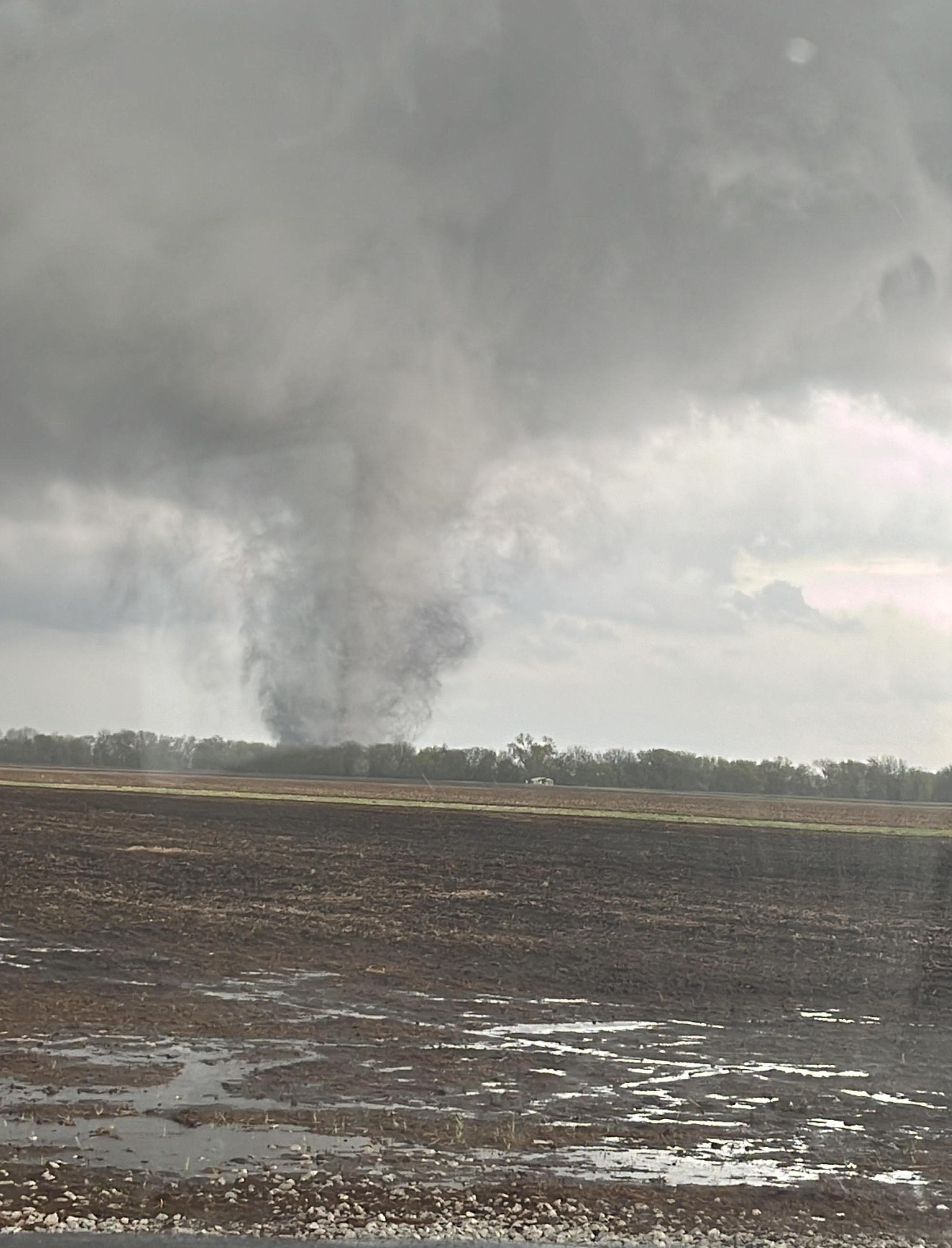
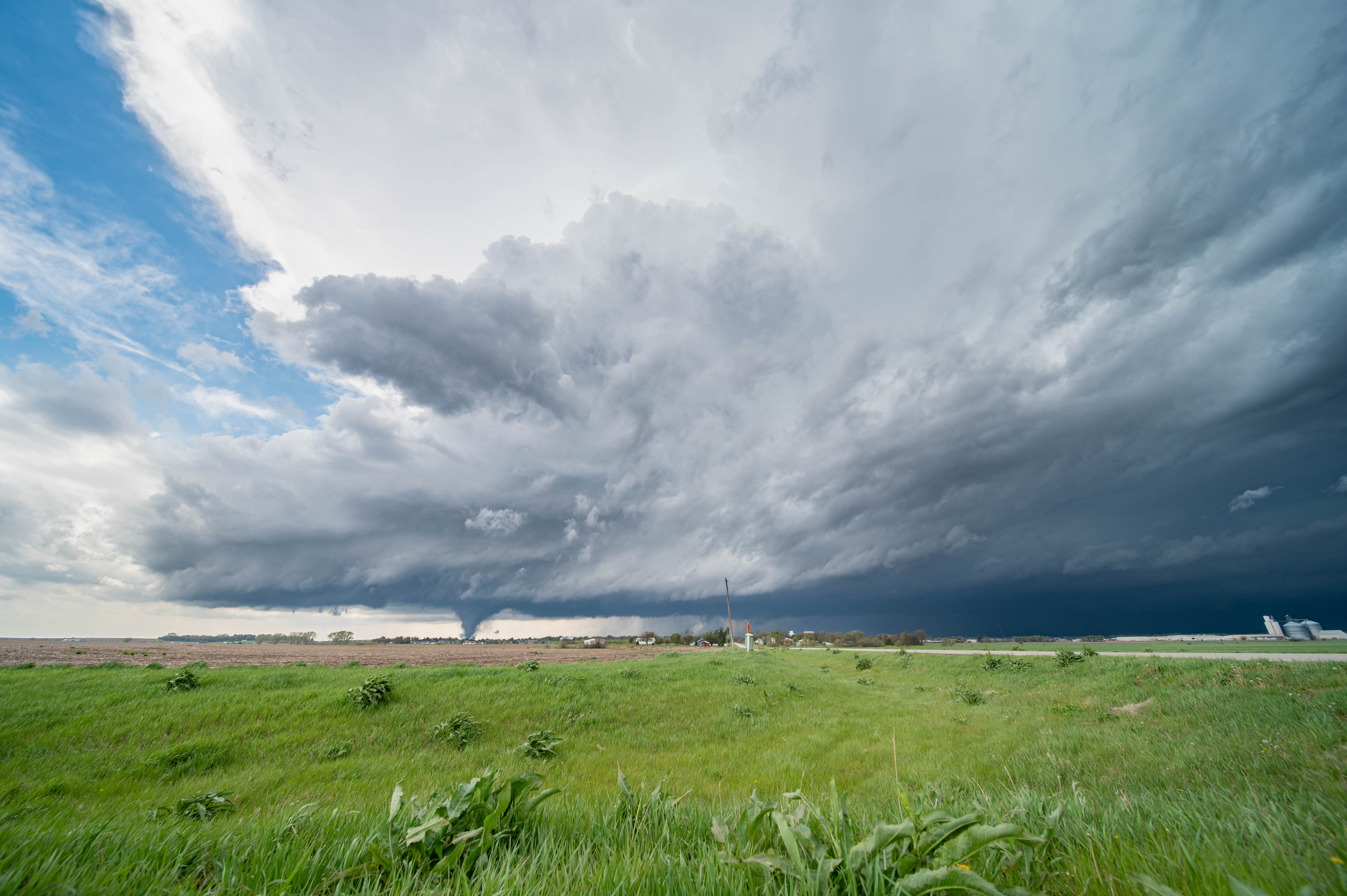
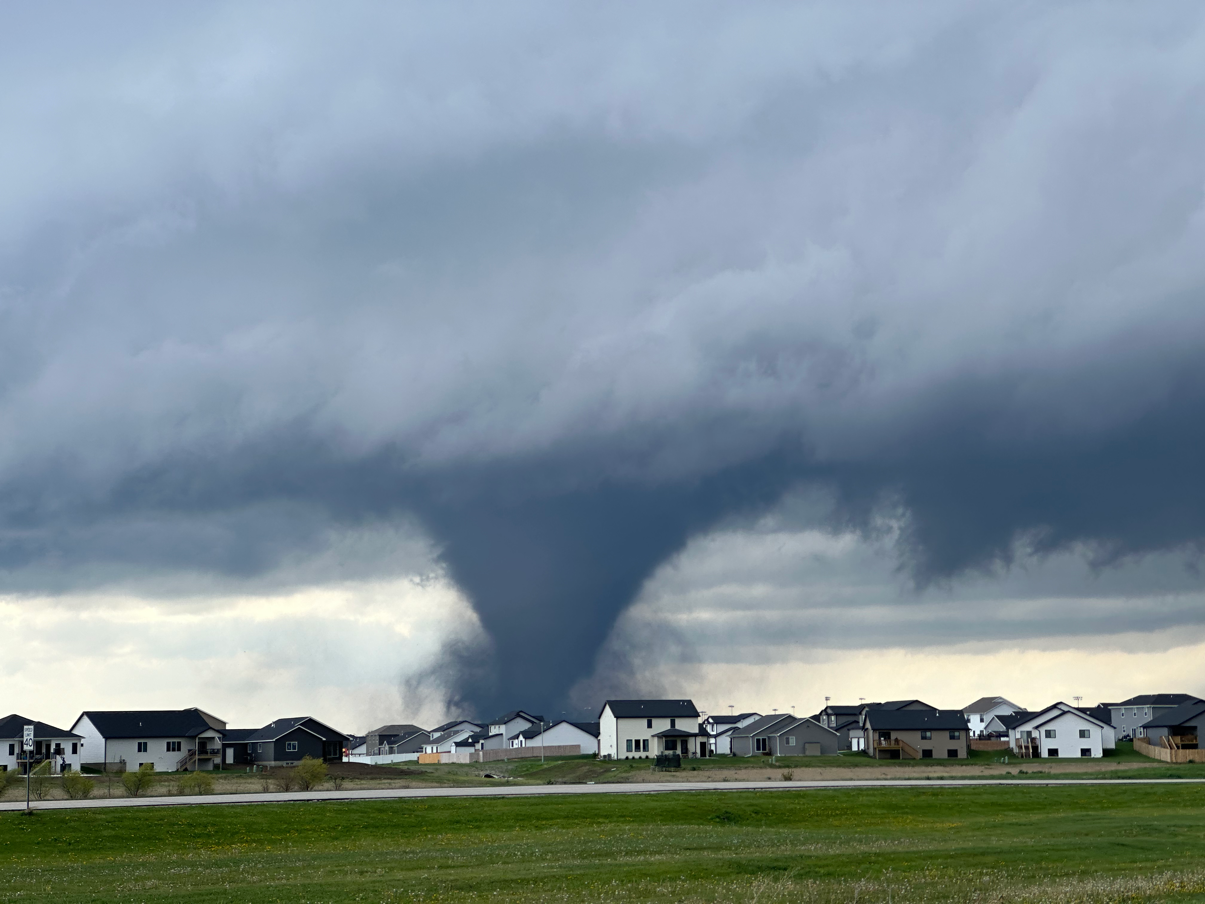
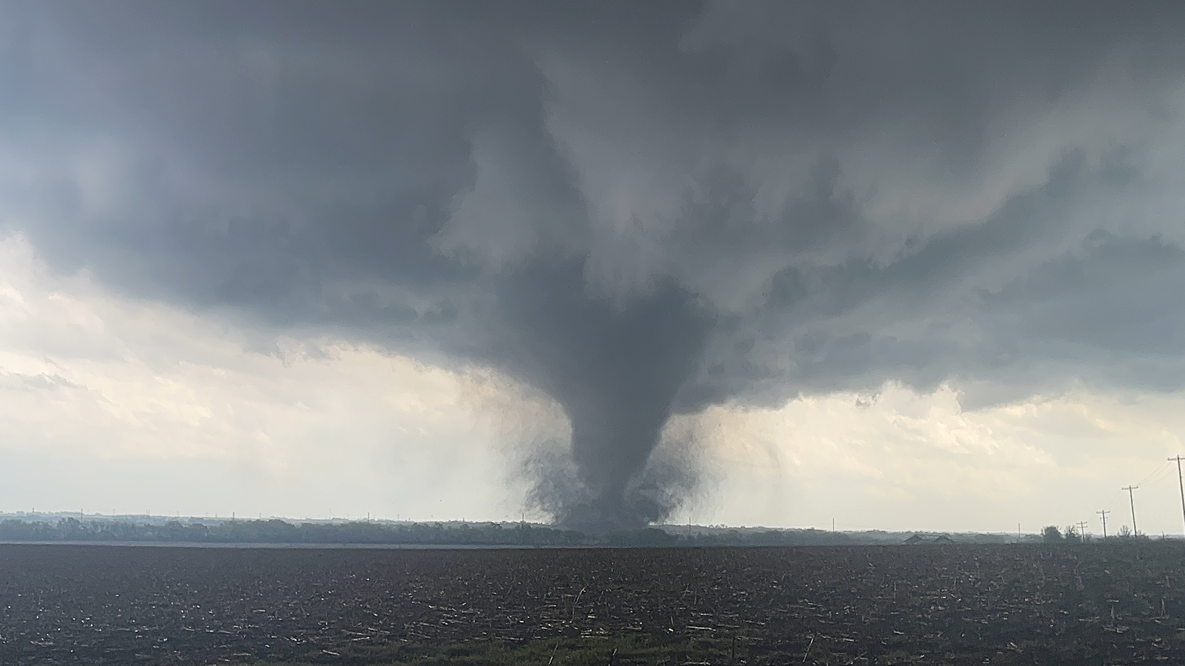
A tornado outbreak occurred across Nebraska and Iowa during the
afternoon and evening hours of Friday, April 26, 2024. Several
significant, long-tracked tornadoes damaged or destroyed hundreds,
if not thousands, of homes and businesses across the region.
People across the region were deeply impacted, several were
injured, and there was one fatality. At the National Weather
Service, our hearts are with all of those impacted, including our
friends, our neighbors, and everyone who has been affected by
these devastating tornadoes.

Historically speaking, these are the strongest tornadoes in
eastern Nebraska or western Iowa (the NWS Omaha/Valley coverage
area) in nearly 10 years, when four EF-4 tornadoes impacted northeast
Nebraska (including Pilger) on June 16, 2014.

NWS Omaha/Valley would like to send our sincere appreciation and
thanks to our media partners for sharing the warnings and urging
people to safety in advance of these tornadoes. We would also like
to send our deepest appreciation to emergency management, law
enforcement, and first responders of all kinds who responded to
this disaster. We are also so thankful to our storm spotters who
reported play-by-play tornado information directly to the NWS,
helping us to provide key information in warning products.

NWS Omaha/Valley would like to thank our co-workers from Kansas
City, St Louis, Hastings, and Sioux Falls for coming to assist
with these damage surveys. Your help, years of experience with
high-end damage evaluation, and expertise in these challenging
evaluations is very much appreciated!

~ NWS Omaha/Valley
|
Statistics (For Tornadoes in the NWS Omaha Coverage Area)

* Total Number of Tornado Tracks: 25
* Total Track Length of All Combined Tornadoes: 208.1 miles
* Combined time tornadoes were on the ground: 6 hours and 16 min
* Maximum Tornado Wind Speed Based on Ground Level Damage
  Assessments: 170 mph
* Maximum Single Tornado Track Length: 40.9 miles
* Maximum Tornado Width: 1900 yards (1.1 miles) for both the Elkhorn and
Minden Tornadoes

Tornado Counts
(For Tornadoes in the NWS Omaha Coverage Area)
* EF-4: 1
* EF-3: 4
* EF-2: 2
* EF-1: 10
* EF-0: 3
* EF-Unknown: 5
|
Tornadoes
|
Tornado - Wolbach / Primrose Areas
Track Map 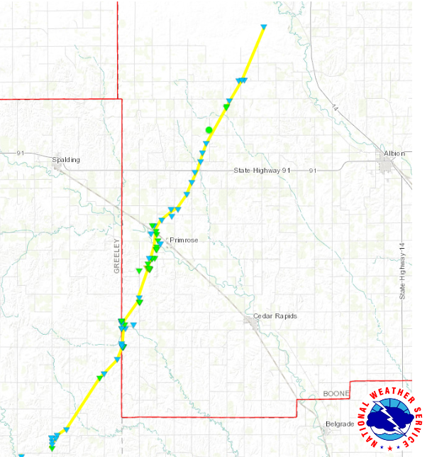  |
||||||||||||||||
|
||||||||||||||||
|
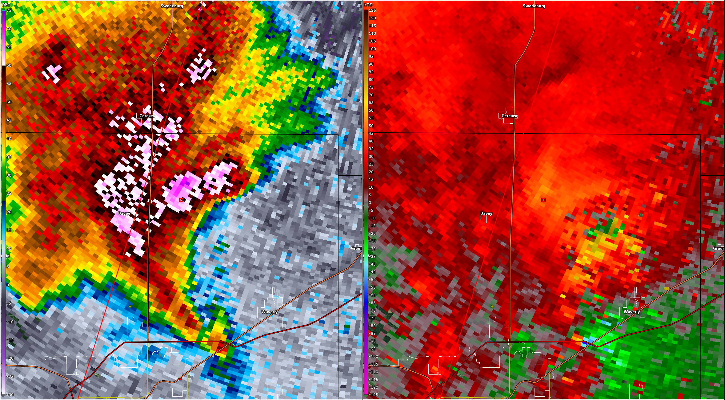
Tornado - Lincoln / Waverly Areas
Track Map 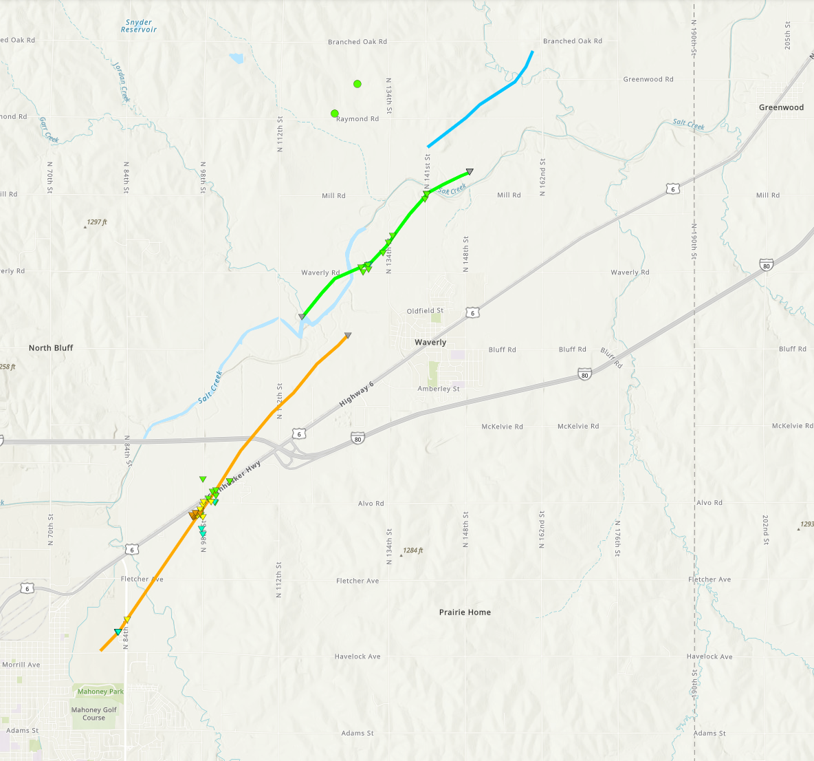 |
||||||||||||||||
|
||||||||||||||||
|
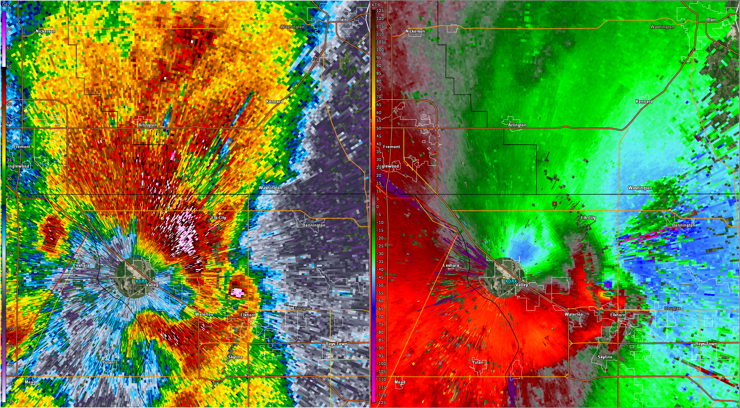
Tornado - Elkhorn / Bennington / Blair Areas
Track Map 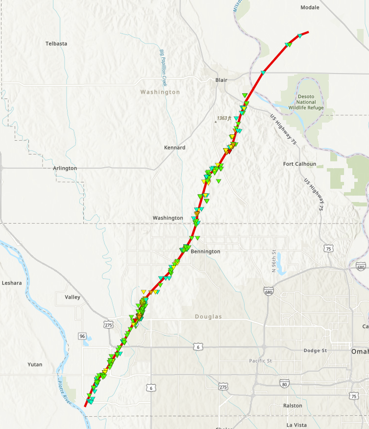 |
||||||||||||||||||||||||||||||||||||||||
|
||||||||||||||||||||||||||||||||||||||||
|
Tornado - Pacific Junction to Pony Creek Park
Track Map 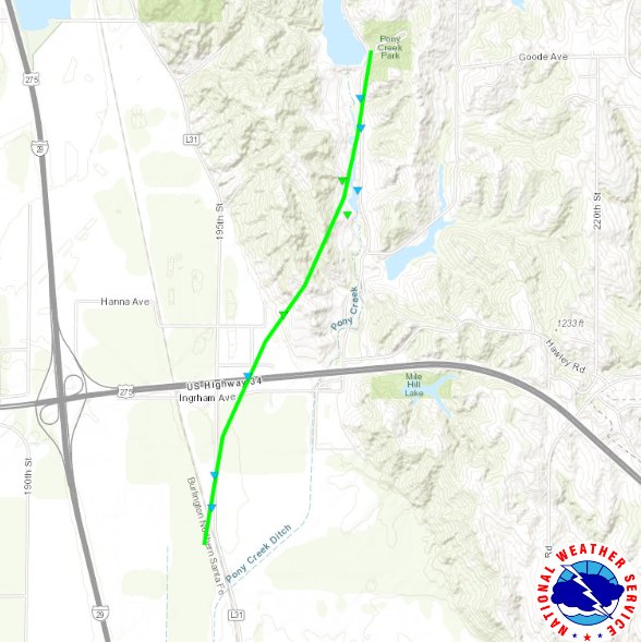 |
||||||||||||||||
|
||||||||||||||||
|
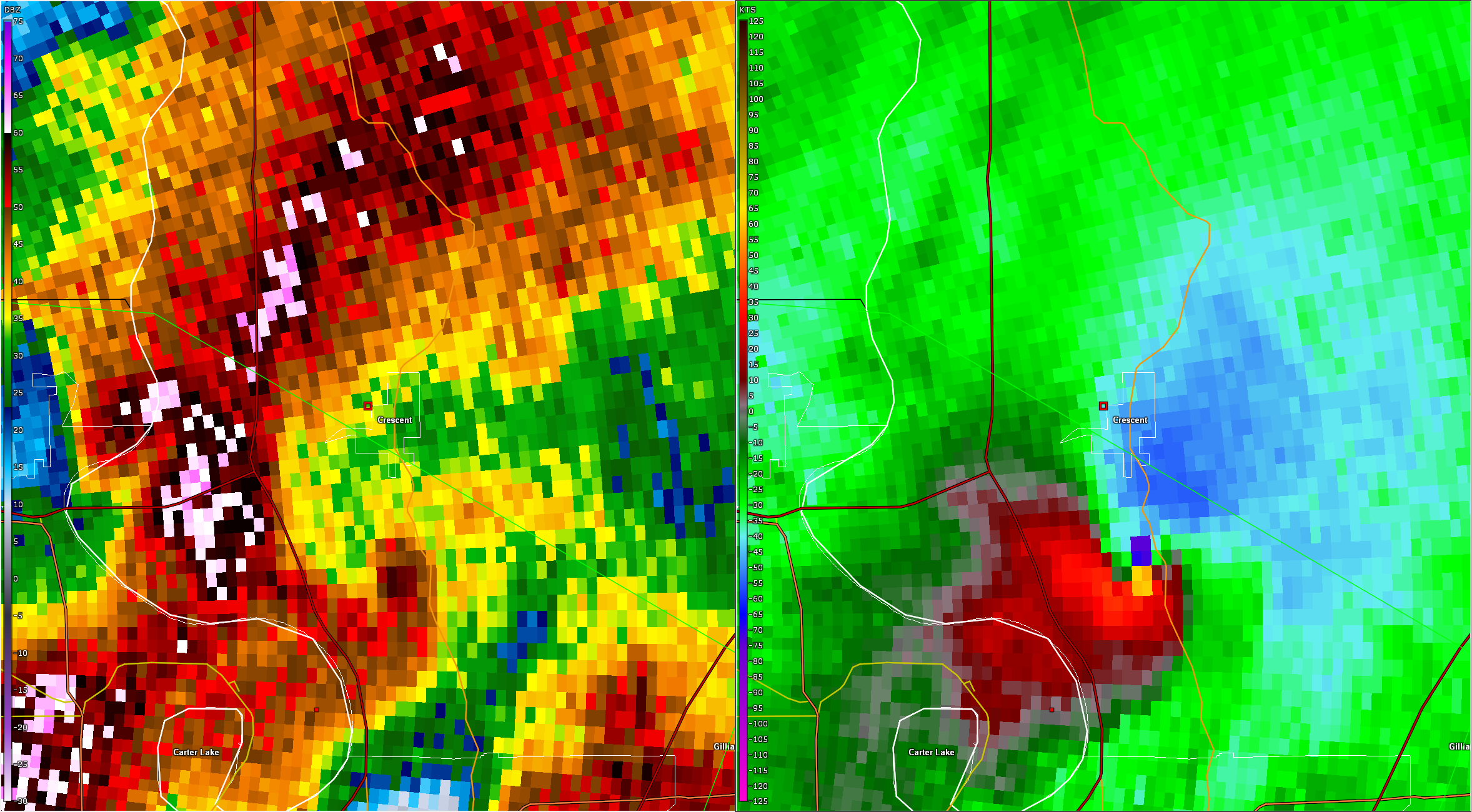
Tornado - Eppley Airfield / Crescent IA Areas
Track Map 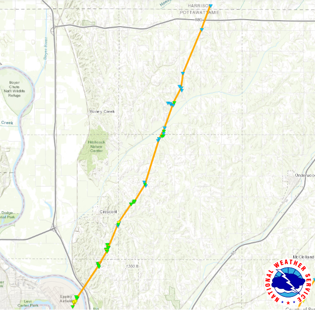 |
||||||||||||||||
|
||||||||||||||||
|
Tornado - Treynor / McClelland Areas
Track Map 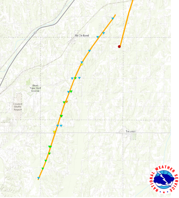 |
||||||||||||||||
|
||||||||||||||||
|
Tornado - Norfolk Area
Track Map 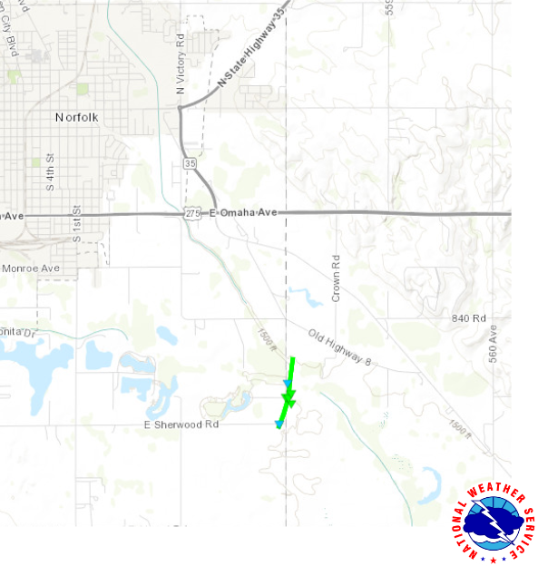 |
||||||||||||||||
|
||||||||||||||||
|
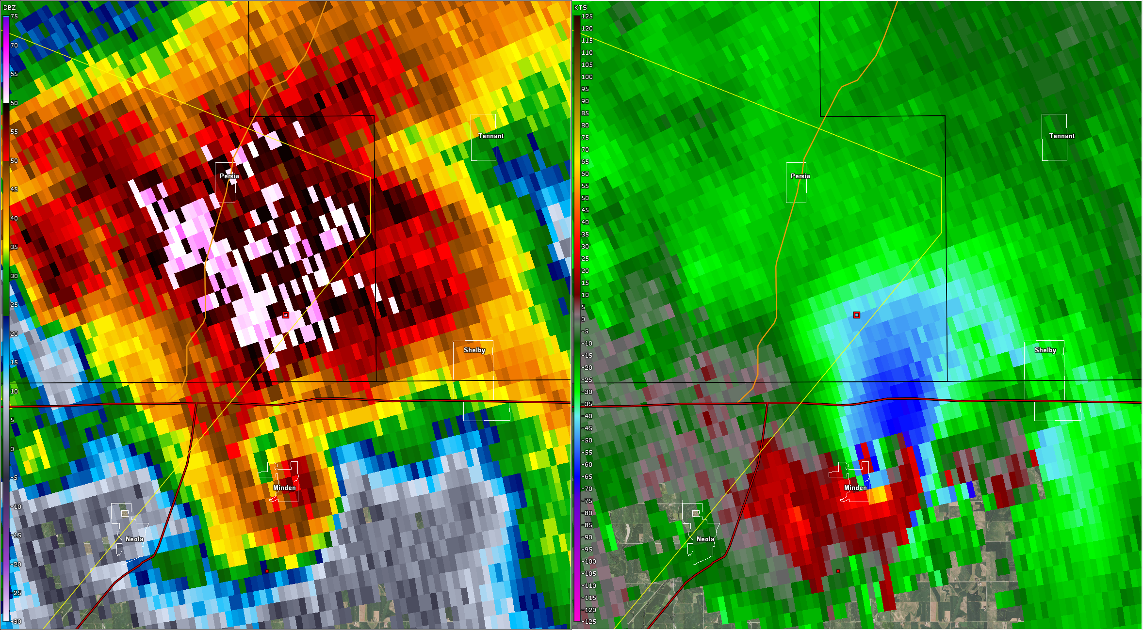
Tornado - Minden / Shelby / Tennant / Harlan / Defiance Areas
Track Map 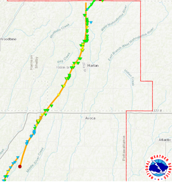 |
||||||||||||||||||||||||||||||||
|
||||||||||||||||||||||||||||||||
|
Tornado - Manilla Area
Track Map 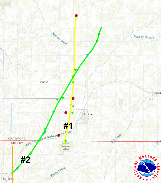 |
||||||||||||||||
|
||||||||||||||||
|
Tornado - Defiance / Manilla Areas
Track Map 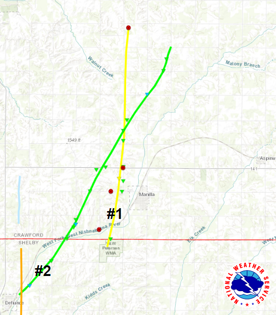 |
||||||||||||||||
|
||||||||||||||||
|
Tornado - Butler County Tornadoes #1 and #2, south of David City
Track Map 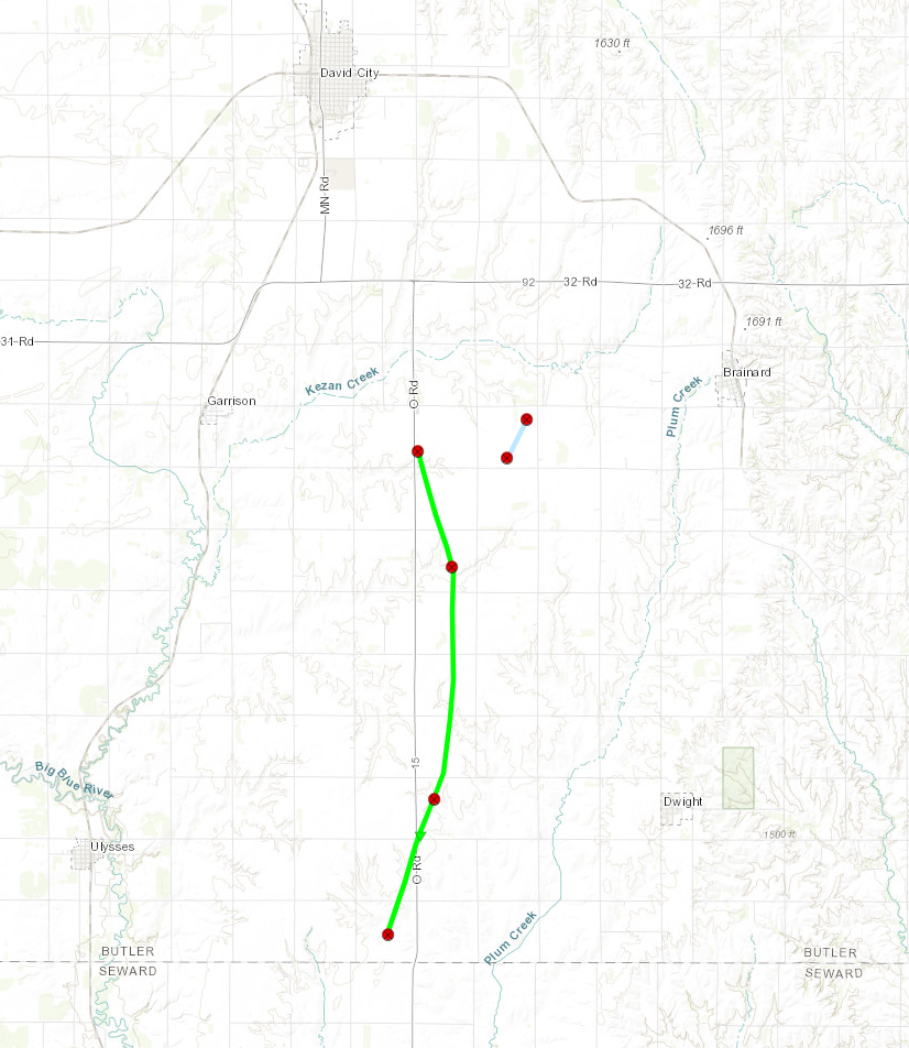 |
||||||||||||||||
|
||||||||||||||||
|
Tornado - Platte County South of Creston
Track Map 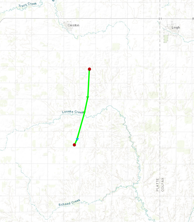 |
||||||||||||||||
|
Tornado - Ashland/Memphis Area
Track Map 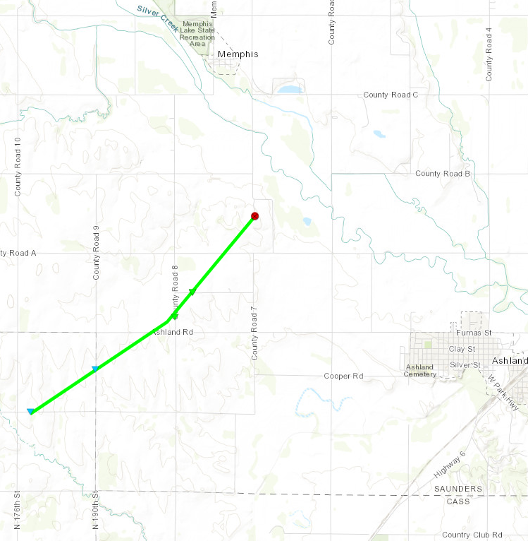 |
||||||||||||||||
|
Tornado #1 and #2 - Waverly/Greenwood Area
Track Map |
||||||||||||||||
|
Tornado - Pisgah Area #1
Track Map 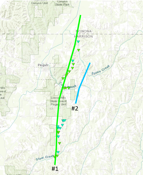 |
||||||||||||||||
|
Tornado - Pisgah Area #2
Track Map |
||||||||||||||||
|
Tornado - Moorhead/Soldier
Track Map 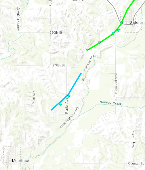 |
||||||||||||||||
|
||||||||||||||||
|
Tornado - Soldier Area
Track Map 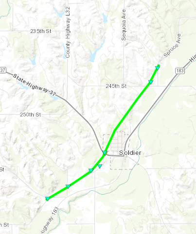 |
||||||||||||||||
|
||||||||||||||||
|
Tornado - Logan Area
Track Map 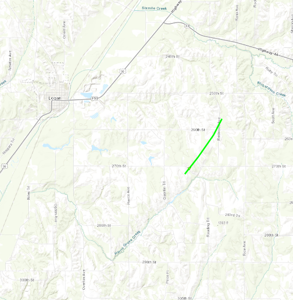 |
||||||||||||||||
|
||||||||||||||||
|
Tornado - Eastern Boone County Tornadoes #1 and #2
Track Map 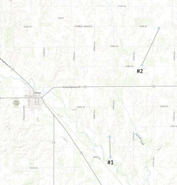 |
||||||||||||||||
|
Tornado - Richardson County Tornadoes #1 and #2
Track Map 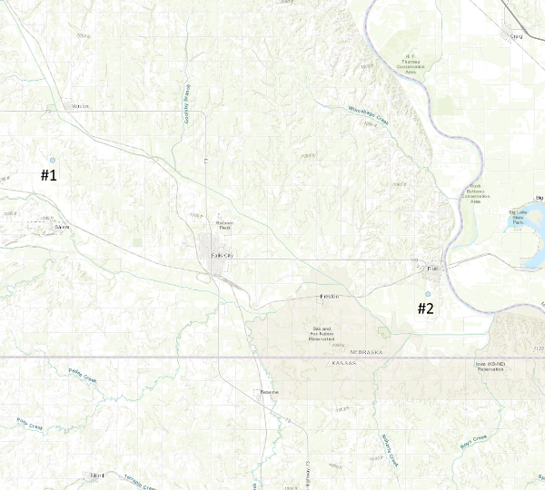 |
||||||||||||||||
| EF0 Weak 65-85 mph |
EF1 Moderate 86-110 mph |
EF2 Significant 111-135 mph |
EF3 Severe 136-165 mph |
EF4 Extreme 166-200 mph |
EF5 Catastrophic 200+ mph |
 |
|||||
Hail:
Hail
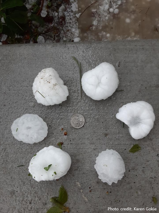 |
| Near Davey, Nebraska |
Flooding
Radar/Warnings
 |
 |
 |
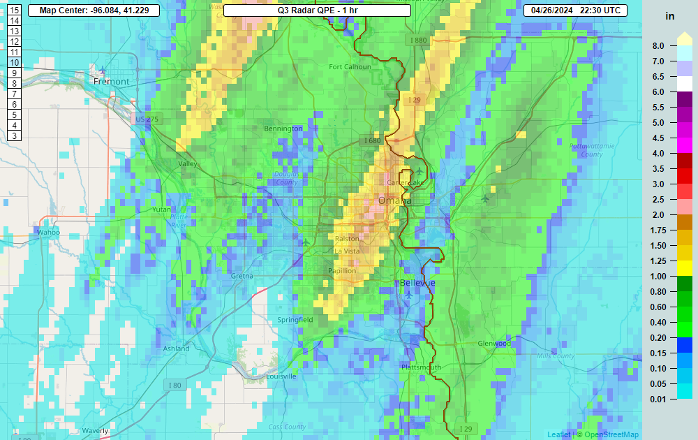 |
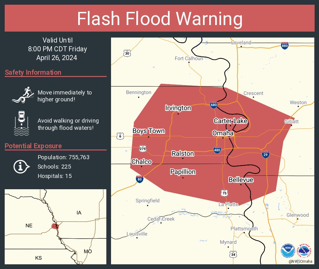
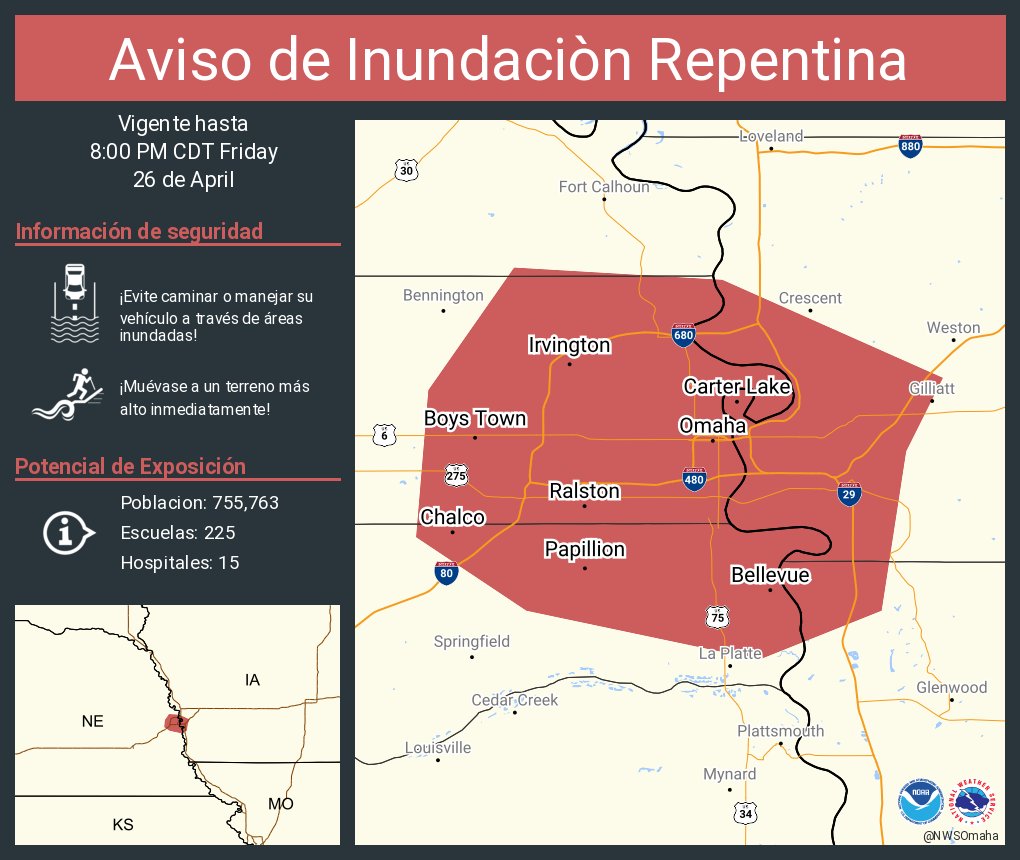
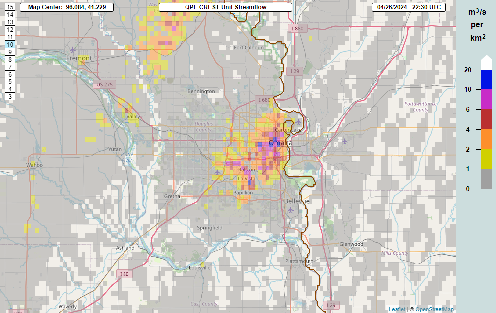
| Flash Flood Warning issued for the Omaha/CB metro | Advertencia de inundación repentina para Omaha/Council Bluffs | MRMS CREST data shows a significant runoff response from the quick heavy rain, especially in northeast Omaha. | Radar rainfall estimates were 1 to 2 inches. The heaviest amounts were just west of Carter Lake, Iowa including the North Omaha area. |
Photos & Video
Header
| Caption (source) |
Caption (source) |
Caption (source) |
Caption (source) |
Radar
Header
 |
 |
 |
 |
| Northeast Lincoln/Waverly tornado at peak intensity | Elkhorn, NE tornado at peak intensity | The Eppley Airfield/Crescent, IA tornado at peak intensity | The Minden, IA tornado at peak intensity. |
Storm Reports
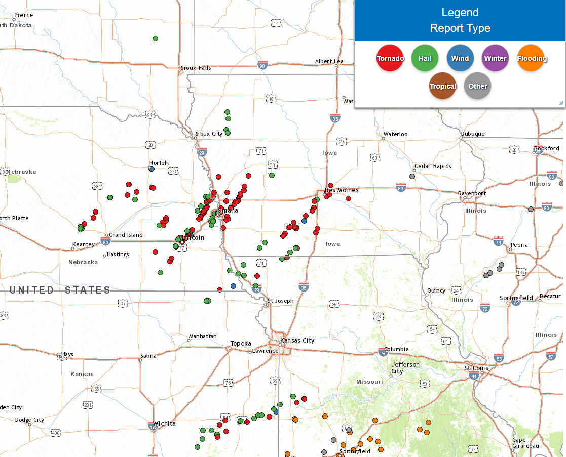 |
| Storm Reports |
..TIME... ...EVENT... ...CITY LOCATION... ...LAT.LON...
..DATE... ....MAG.... ..COUNTY LOCATION..ST.. ...SOURCE....
..REMARKS..
0130 PM Hail 6 S Western 40.31N 97.18W
04/26/2024 M1.00 Inch Jefferson NE Public
0143 PM Funnel Cloud Friend 40.65N 97.29W
04/26/2024 Saline NE Fire Dept/Rescue
0205 PM Funnel Cloud 4 NNE Wilber 40.54N 96.94W
04/26/2024 Saline NE Law Enforcement
0205 PM Funnel Cloud 1 NW Wilber 40.49N 96.97W
04/26/2024 Saline NE County Official
Dispatch called over NAWAS reporting a
funnel cloud 15 miles west of Cortland, or 2
miles northwest of Wilber.
0215 PM Hail 6 WSW Cedar Rapids 41.54N 98.26W
04/26/2024 M1.75 Inch Boone NE Public
0215 PM Hail 6 W Cedar Rapids 41.54N 98.26W
04/26/2024 E1.75 Inch Boone NE Public
Report from mPING: Golf Ball (1.75 in.).
0224 PM Hail Denton 40.74N 96.85W
04/26/2024 M1.00 Inch Lancaster NE Public
Report of hail ranging from half an inch to
an inch in Denton, NE.
0227 PM Hail 1 SE Denton 40.73N 96.84W
04/26/2024 M1.00 Inch Lancaster NE Amateur Radio
ground covered with hail.
0235 PM Hail Ulysses 41.08N 97.20W
04/26/2024 E1.75 Inch Butler NE Emergency Mngr
Butler County Emergency Manager reported
golf ball sized hail in downtown Ulysses.
0241 PM Hail 4 NW Lincoln 40.86N 96.74W
04/26/2024 E1.50 Inch Lancaster NE Public
0242 PM Funnel Cloud 1 WSW Lincoln 40.81N 96.71W
04/26/2024 Lancaster NE Trained Spotter
Over downtown Lincoln.
0243 PM Tornado 5 NW Lincoln 40.88N 96.75W
04/26/2024 Lancaster NE Emergency Mngr
Brief tornado touchdown near the Kawasaki
Plant.
0248 PM Hail 5 NW Lincoln 40.87N 96.74W
04/26/2024 E1.75 Inch Lancaster NE Public
Report from mPING: Golf Ball (1.75 in.).
0248 PM Hail 5 NNW Lincoln 40.87N 96.73W
04/26/2024 M1.75 Inch Lancaster NE Public
0249 PM Hail 6 SE Malcolm 40.85N 96.79W
04/26/2024 E1.25 Inch Lancaster NE Public
0250 PM Tornado 5 NNE Lincoln 40.87N 96.64W
04/26/2024 Lancaster NE Trained Spotter
0251 PM Tornado 4 SW Waverly 40.88N 96.59W
04/26/2024 Lancaster NE Emergency Mngr
Building collapse.
0253 PM Tornado 1 NW Waverly 40.93N 96.55W
04/26/2024 Lancaster NE 911 Call Center
House damaged.
0254 PM Hail 3 E Davey 40.99N 96.60W
04/26/2024 M2.50 Inch Lancaster NE Public
delayed report time estimated by radar.
0254 PM Tornado 5 W Dwight 41.08N 97.11W
04/26/2024 Butler NE Trained Spotter
Relayed from emergency management.
0255 PM Tstm Wnd Dmg 1 NE Waverly 40.92N 96.52W
04/26/2024 Lancaster NE Emergency Mngr
Numerous reports of damage near Waverly,
including trains blown off tracks, semis
overturned.
0255 PM Tstm Wnd Dmg 4 SW Waverly 40.88N 96.59W
04/26/2024 Lancaster NE Emergency Mngr
Building collapsed with people inside.
Potential gas leak.
0257 PM Tornado 4 SW Waverly 40.89N 96.59W
04/26/2024 Lancaster NE Emergency Mngr
Train derailment Hwy 6. Additional train
derailment Hwy 6 and I-480. Semi-rolled
over.
0259 PM Tornado 2 WNW Waverly 40.93N 96.57W
04/26/2024 Lancaster NE Emergency Mngr
0300 PM Tornado 4 SSE Garrison 41.13N 97.13W
04/26/2024 Butler NE Public
Social media photo of confirmed tornado 9
miles south of David City, Nebraska.
0301 PM Funnel Cloud 3 WSW Brainard 41.16N 97.06W
04/26/2024 Butler NE Emergency Mngr
Two seminars flipped over Hwy 15.
0305 PM Tornado 4 WNW Brainard 41.21N 97.06W
04/26/2024 Butler NE Emergency Mngr
0306 PM Tornado 2 WNW Saint Edward 41.58N 97.89W
04/26/2024 Boone NE Broadcast Media
Small rope tornado.
0307 PM Tornado 3 WSW Brainard 41.17N 97.06W
04/26/2024 Butler NE Trained Spotter
Trained spotter reported a tornado just
southwest of Brainard, Nebraska. Tornado has
since lifted but there are two additional
funnel clouds currently.
0315 PM Tornado 4 NNW Greenwood 41.01N 96.48W
04/26/2024 Lancaster NE 911 Call Center
EM relayed report from 911 call center of
confirmed tornado to the west of Ashland,
Nebraska.
0325 PM Tornado 5 SE Yutan 41.19N 96.34W
04/26/2024 Saunders NE Law Enforcement
0329 PM Tornado 5 S Lindsay 41.63N 97.69W
04/26/2024 Platte NE Emergency Mngr
Emergency manager reported a tornado on the
ground 4 to 5 miles south of Lindsay.
0330 PM Tornado 5 ESE Yutan 41.20N 96.31W
04/26/2024 Douglas NE Park/Forest Srvc
0333 PM Hail 1 WNW Valley 41.32N 96.37W
04/26/2024 M1.00 Inch Douglas NE Official NWS Obs
0336 PM Tornado 5 ESE Yutan 41.22N 96.31W
04/26/2024 Douglas NE Law Enforcement
0337 PM Tornado 2 S Waterloo 41.26N 96.28W
04/26/2024 Douglas NE 911 Call Center
Vehicle and building damage.
0339 PM Tornado 1 N Elkhorn 41.29N 96.23W
04/26/2024 Douglas NE Trained Spotter
House with severe roof damage.
0340 PM Tornado 4 SSW Waterloo 41.23N 96.30W
04/26/2024 Douglas NE Law Enforcement
240th and Dodge.
0345 PM Tornado 1 NW Elkhorn 41.29N 96.26W
04/26/2024 Douglas NE Amateur Radio
Very large tornado moving into western
Elkhorn.
0347 PM Tornado 1 NNW Elkhorn 41.29N 96.24W
04/26/2024 Douglas NE Trained Spotter
Very large tornado moving through western
Elkhorn.
0347 PM Tornado 5 W Newman Grove 41.75N 97.87W
04/26/2024 Boone NE Emergency Mngr
Emergency Manager reported confirmed large
tornado 4 to 5 miles west of Newman Grove.
0349 PM Tornado 3 N Elkhorn 41.32N 96.23W
04/26/2024 Douglas NE Law Enforcement
Very large tornado near 204th and Ida.
0350 PM Tornado 4 W Newman Grove 41.75N 97.86W
04/26/2024 Boone NE Emergency Mngr
Tornado moving east.
0352 PM Tornado 3 N Elkhorn 41.32N 96.23W
04/26/2024 Douglas NE Public
Very large tornado near Flanagan Lake.
0355 PM Tornado 2 WSW Bennington 41.35N 96.20W
04/26/2024 Douglas NE Amateur Radio
Major structural damage to at least 10
homes.
0359 PM Tornado 2 NNW Bennington 41.39N 96.17W
04/26/2024 Douglas NE Emergency Mngr
0400 PM Tornado 2 WSW Bennington 41.36N 96.18W
04/26/2024 Douglas NE Public
Multiple homes destroyed.
0405 PM Tornado 2 SE Kennard 41.46N 96.18W
04/26/2024 Washington NE Emergency Mngr
Homes damaged.
0408 PM Hail Blair 41.55N 96.14W
04/26/2024 M1.25 Inch Washington NE Public
0408 PM Tornado 4 E Kennard 41.47N 96.13W
04/26/2024 Washington NE Law Enforcement
Destroyed homes.
0410 PM Tornado 4 SSE Blair 41.49N 96.11W
04/26/2024 Washington NE Emergency Mngr
0412 PM Hail Blair 41.55N 96.14W
04/26/2024 E1.75 Inch Washington NE Public
Report from mPING: Golf Ball (1.75 in.).
0416 PM Tornado 1 SSE Creston 41.70N 97.36W
04/26/2024 Platte NE Public
Tornado on the ground south on 18th ave.
0418 PM Tornado 4 SE Blair 41.51N 96.07W
04/26/2024 Washington NE Trained Spotter
0420 PM Tornado 5 SSW Modale 41.55N 96.04W
04/26/2024 Harrison IA Trained Spotter
0423 PM Tornado 2 SE Creston 41.69N 97.33W
04/26/2024 Platte NE Emergency Mngr
Multiple vortex tornado.
0425 PM Hail 1 WNW Valley 41.32N 96.37W
04/26/2024 M1.00 Inch Douglas NE Official NWS Obs
0426 PM Hail 5 W Washington 41.40N 96.30W
04/26/2024 E1.00 Inch Washington NE Public
Report from mPING: Quarter (1.00 in.).
0430 PM Hail 2 WSW La Vista 41.18N 96.07W
04/26/2024 E1.00 Inch Sarpy NE Public
0432 PM Funnel Cloud 8 E Du Bois 40.02N 95.89W
04/26/2024 Richardson NE NWS Employee
Relay from NWS TOP.
0435 PM Tornado Modale 41.62N 96.01W
04/26/2024 Harrison IA Trained Spotter
Tornado near Modale looks like it roped out.
0440 PM Hail 2 SSW Papillion 41.13N 96.06W
04/26/2024 M1.00 Inch Sarpy NE Trained Spotter
0440 PM Hail 1 WNW Ralston 41.21N 96.05W
04/26/2024 M1.00 Inch Douglas NE Public
0442 PM Hail 3 NE Cedar Creek 41.09N 96.07W
04/26/2024 E1.75 Inch Sarpy NE Public
Report from mPING: Golf Ball (1.75 in.).
0443 PM Hail 2 W Papillion 41.15N 96.08W
04/26/2024 E1.75 Inch Sarpy NE Public
Report from mPING: Golf Ball (1.75 in.).
0445 PM Hail Papillion 41.15N 96.04W
04/26/2024 M2.00 Inch Sarpy NE Public
0446 PM Hail 3 W Blair 41.55N 96.19W
04/26/2024 E1.00 Inch Washington NE Public
Report from mPING: Quarter (1.00 in.).
0447 PM Hail 1 SW Papillion 41.14N 96.06W
04/26/2024 E1.50 Inch Sarpy NE Public
0455 PM Hail 1 NW Carter Lake 41.30N 95.94W
04/26/2024 E1.75 Inch Douglas NE Public
0455 PM Hail 5 NE Omaha 41.30N 95.93W
04/26/2024 M1.75 Inch Douglas NE Public
0455 PM Hail Carter Lake 41.29N 95.91W
04/26/2024 E1.75 Inch Pottawattamie IA Emergency Mngr
0455 PM Hail 1 NNE Omaha 41.28N 96.00W
04/26/2024 E1.00 Inch Douglas NE Public
0456 PM Hail 1 ENE Papillion 41.16N 96.02W
04/26/2024 E1.00 Inch Sarpy NE Emergency Mngr
0456 PM Tornado 4 E Omaha 41.27N 95.93W
04/26/2024 Douglas NE NWS Employee
0457 PM Tornado 2 NNW Pacific Junction 41.04N 95.82W
04/26/2024 Mills IA Trained Spotter
0501 PM Tornado 3 ENE Carter Lake 41.30N 95.87W
04/26/2024 Pottawattamie IA Emergency Mngr
0502 PM Hail Nemaha 40.34N 95.67W
04/26/2024 E2.75 Inch Nemaha NE Emergency Mngr
0505 PM Tornado 3 NNE Pisgah 41.87N 95.91W
04/26/2024 Monona IA Storm Chaser
0507 PM Tornado 1 S Crescent 41.36N 95.86W
04/26/2024 Pottawattamie IA Emergency Mngr
0509 PM Tornado 7 SE Council Bluffs 41.17N 95.75W
04/26/2024 Pottawattamie IA Trained Spotter
0513 PM Tornado 6 W Treynor 41.23N 95.73W
04/26/2024 Pottawattamie IA Storm Chaser
0514 PM Tornado 6 WSW Treynor 41.19N 95.70W
04/26/2024 Pottawattamie IA Emergency Mngr
0518 PM Tstm Wnd Gst 1 NNE Falls City 40.08N 95.59W
04/26/2024 M58 MPH Richardson NE ASOS
0520 PM Tornado 3 SE Norfolk 42.00N 97.37W
04/26/2024 Stanton NE Emergency Mngr
Possible tornado.
0520 PM Tstm Wnd Dmg 4 SE Norfolk 42.00N 97.36W
04/26/2024 Stanton NE Emergency Mngr
delayed report Roof taken off athletic
training center.
0520 PM Tornado 7 WNW Neola 41.48N 95.75W
04/26/2024 Pottawattamie IA Trained Spotter
0528 PM Tornado 3 SE Underwood 41.36N 95.65W
04/26/2024 Pottawattamie IA Emergency Mngr
0533 PM Tornado 2 SE Underwood 41.37N 95.65W
04/26/2024 Pottawattamie IA Emergency Mngr
0540 PM Tornado 3 ESE Neola 41.43N 95.57W
04/26/2024 Pottawattamie IA Storm Chaser
0541 PM Tornado Minden 41.47N 95.54W
04/26/2024 Pottawattamie IA Emergency Mngr
Very large tornado.
0541 PM Tornado 4 ESE Logan 41.62N 95.73W
04/26/2024 Harrison IA Storm Chaser
0545 PM Tornado 1 NE Minden 41.48N 95.52W
04/26/2024 Pottawattamie IA Storm Chaser
Large tornado destroying homes.
0547 PM Tornado 2 ENE Minden 41.48N 95.50W
04/26/2024 Pottawattamie IA Emergency Mngr
Very large multi vortex tornado. At least
1/3 mile wide.
0549 PM Tornado 1 W Shelby 41.51N 95.48W
04/26/2024 Shelby IA Law Enforcement
Multiple houses damaged.
0550 PM Tornado 1 WSW Shelby 41.50N 95.48W
04/26/2024 Pottawattamie IA Storm Chaser
Very large tornado crossing Interstate 80.
0557 PM Tornado 3 S Tennant 41.56N 95.45W
04/26/2024 Shelby IA Law Enforcement
Multiple destroyed outbuildings and a home
that lost a roof. Time estimated from radar.
0559 PM Tornado Tennant 41.59N 95.44W
04/26/2024 Shelby IA Broadcast Media
0605 PM Tornado 2 W Harlan 41.65N 95.37W
04/26/2024 Shelby IA Public
Significant damage between Portsmith and
Harlan. Destroyed home, cars flipped.
0605 PM Tornado 3 W Harlan 41.65N 95.38W
04/26/2024 Shelby IA Storm Chaser
Multi vortex tornado.
0606 PM Tornado 2 W Harlan 41.65N 95.37W
04/26/2024 Shelby IA Trained Spotter
Home destroyed.
0608 PM Hail 1 SE Clarinda 40.72N 95.02W
04/26/2024 M1.00 Inch Page IA CO-OP Observer
0617 PM Tornado 2 E Westphalia 41.72N 95.35W
04/26/2024 Shelby IA Storm Chaser
&&
$$
Environment
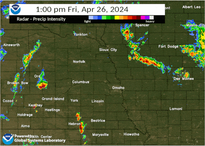
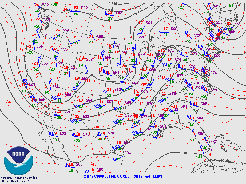
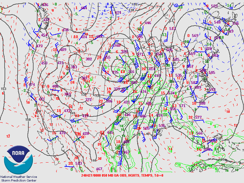
A vigorous low pressure system moving through Nebraska brought the necessary ingredients together for a severe weather outbreak across the region. Strong winds and cold temperatures in the mid levels of the atmosphere (15,000-20,000 ft above the ground) overspread a warm, moist air mass streaming north from the Gulf of America to create a favorable environment for severe thunderstorm development. The storms (supercells) that produced the tornadoes across eastern Nebraska and southwest Iowa developed along a front that moved into eastern Nebraska from the west during the afternoon hours.
 |
 |
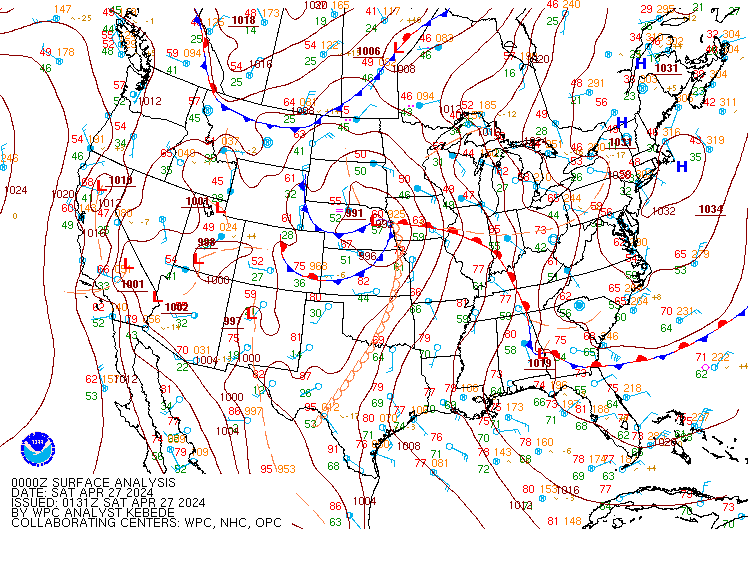 |
| Figure 1: 500-mb map at 7 PM on April 26th | Figure 2: 850-mb map at 7 PM on April 26th | Figure 3: Surface map at 7 PM on April 26th |
Below is a model skew-T and hodograph that is a good representation of environment that the tornadic supercells were moving through.
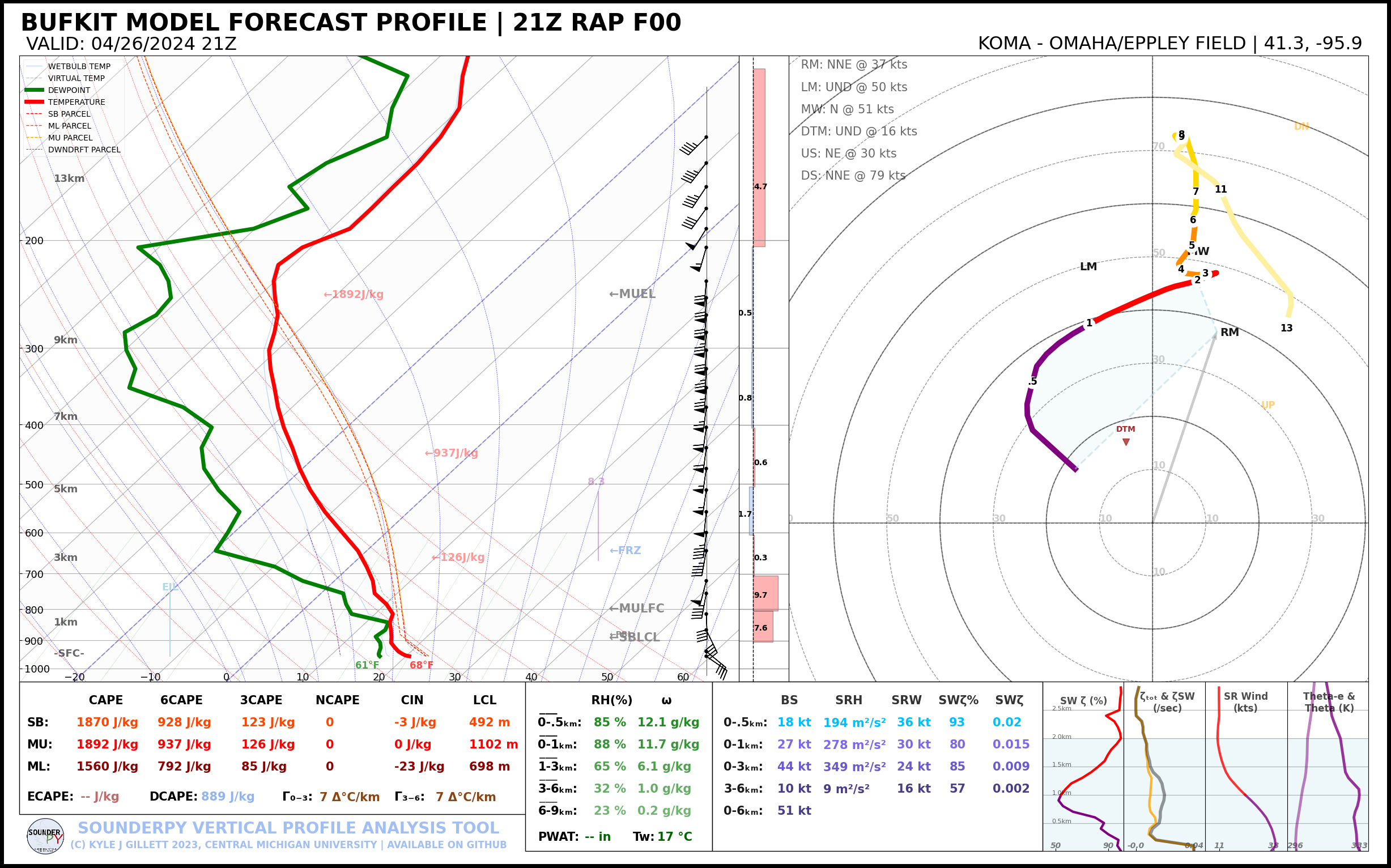 |
| Figure 4: 0-h Forecast from the 21z HRRR for Omaha Eppley Field |
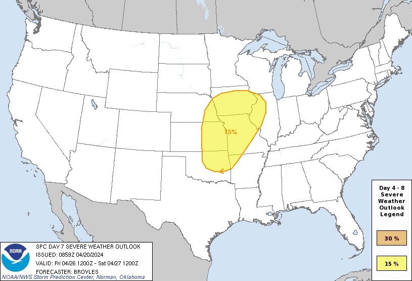
Additional Information
The Forecast
 |
 |
| SPC Day 7 Probabilistic Outlook | SPC Day 6 Probabilistic Outlook |
 |
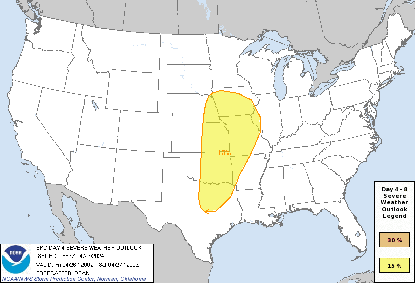 |
| SPC Day 5 Probabilistic Outlook | SPC Day 4 Probabilistic Outlook |
 |
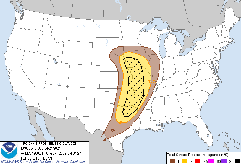 |
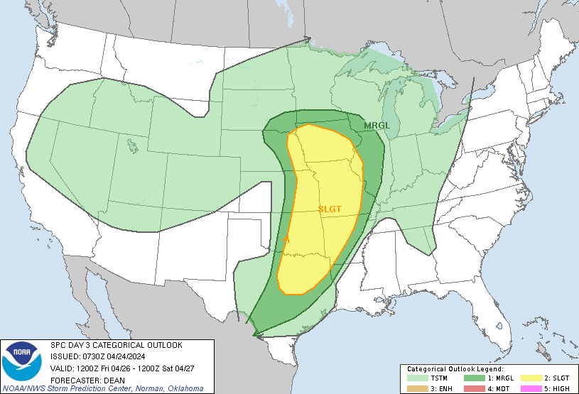
| SPC Day 3 Categorical Outlook | SPC Day 3 Probabilistic Outlook |
 |
 |
 |
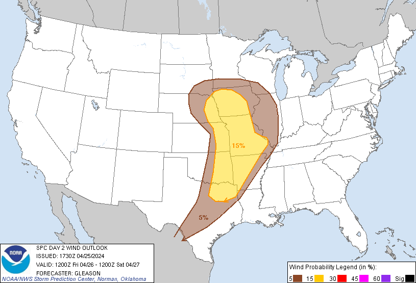 |
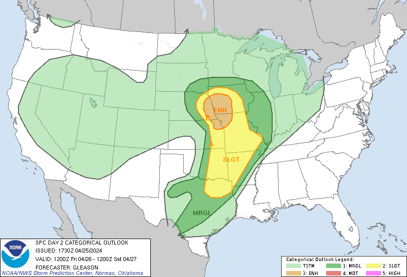
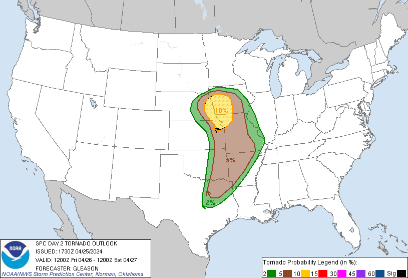
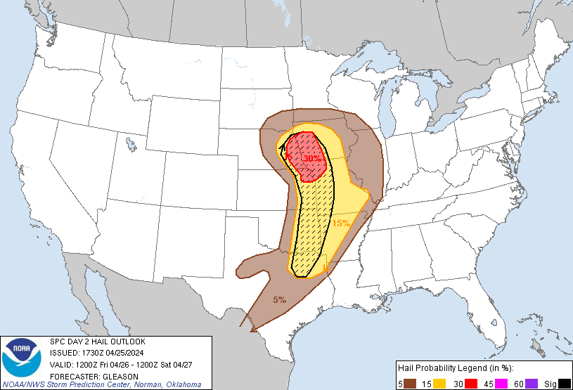
| SPC Day 2 Categorical Outlook | SPC Day 2 Tornado Outlook | SPC Day 2 Hail Outlook | SPC Day 2 Wind Outlook |
 |
 |
 |
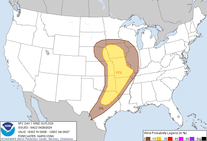 |
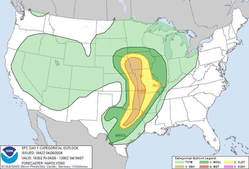
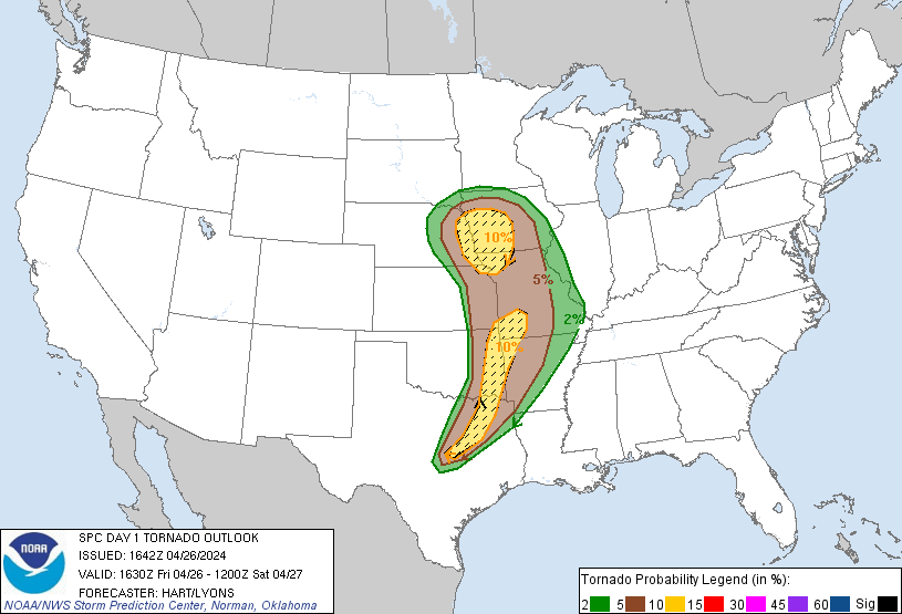
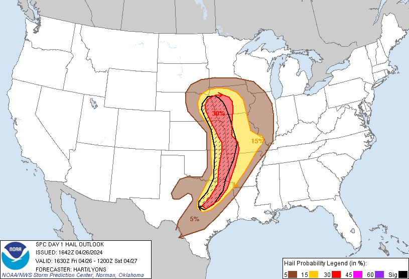
| SPC Day 1 Categorical Outlook | SPC Day 1 Tornado Outlook | SPC Day 1 Hail Outlook | SPC Day 1 Wind Outlook |
Historical Perspective
Top Daily Tornado Counts in the Omaha, NE Area of Responsibility
|
||||||||
| Date | F/EFU | F/EF0 | F/EF1 | F/EF2 | F/EF3 | F/EF4 | F/EF5 | Total |
| 12/15/2021 | 0 | 2 | 15 | 11 | 0 | 0 | 0 | 28 |
| 4/26/2024 | 5 | 3 | 9 | 2 | 5 | 0 | 0 | 24 |
| 5/12/2023 | 4 | 4 | 9 | 3 | 0 | 0 | 0 | 20 |
Top Daily F/EF2+ Tornado Counts in the Omaha, NE Area of Responsibility (since 1950) |
|||||
| Date | F/EF2 | F/EF3 | F/EF4 | F/EF5 | Total |
| 12/15/2021 | 11 | 0 | 0 | 0 | 11 |
| 4/26/2024 | 2 | 5 | 0 | 0 | 7 |
| 6/16/2014 | 1 | 1 | 5 | 0 | 7 |
| 5/6/1975 | 2 | 2 | 3 | 0 | 7 |
Summaries from other NWS Offices
 |
Media use of NWS Web News Stories is encouraged! Please acknowledge the NWS as the source of any news information accessed from this site. |
|