
Heat expands across the Desert Southwest, Plains, Mississippi Valley and Midwest into Monday. Fire weather concerns continue for portions of the Intermountain West. Active monsoonal moisture fuels thunderstorms over the Southwest with possible flash flooding. Tropical cyclone Fausto in the Pacific, should weaken as it approaches Hawaii; Dangerous surf, swells and rip currents are expected. Read More >
Overview
|
During the afternoon and evening of May 22, 2004, ingredients came together for an outbreak of severe thunderstorms and tornadoes across east-central and southeast Nebraska into western Iowa. Nine tornadoes were reported, including an F4 that devastated the small town of Hallam. The Hallam tornado which initially touched down at 7:30 PM CDT just west of Daykin, tracked 52 miles across portions of Jefferson, Saline, Gage, Lancaster and Otoe counties, before lifting at around 9:10 PM CDT just west of Palmyra. In addition to the tornadoes, hail to four inches in diameter was observed, as were damaging straight-line winds. |
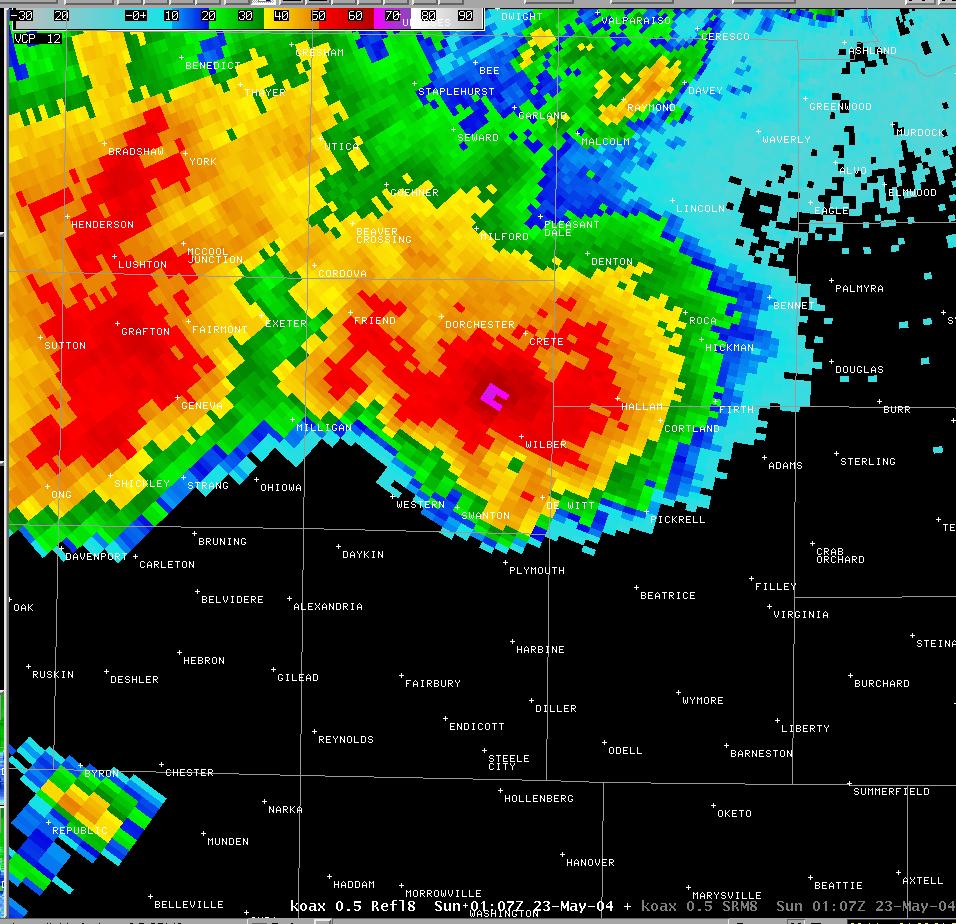
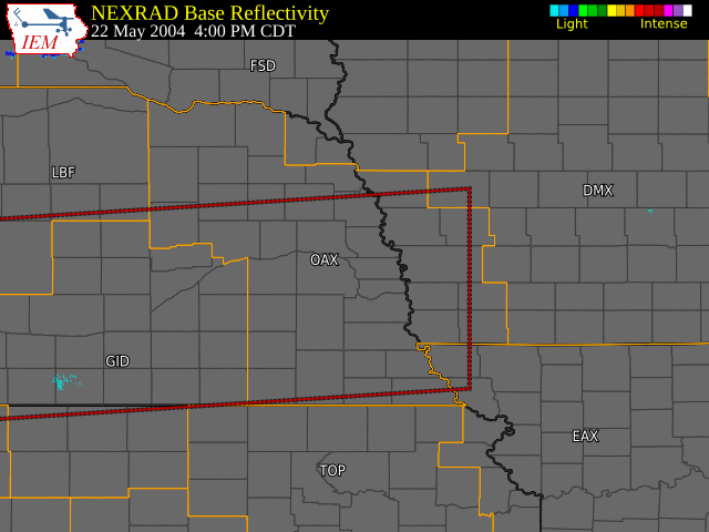 Radar mosaic from 4 PM to Midnight. |
Tornadoes:
|
Tornado - Hallam
Track Map 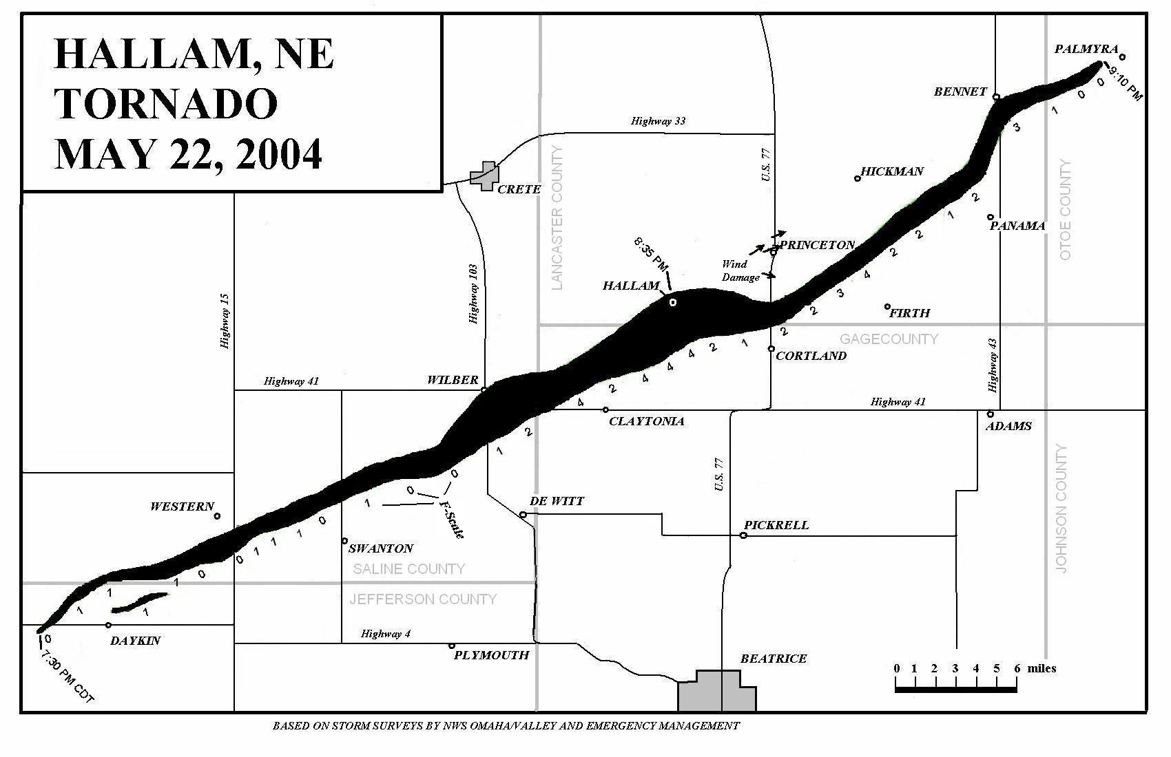 |
||||||||||||||
Photos & Video:
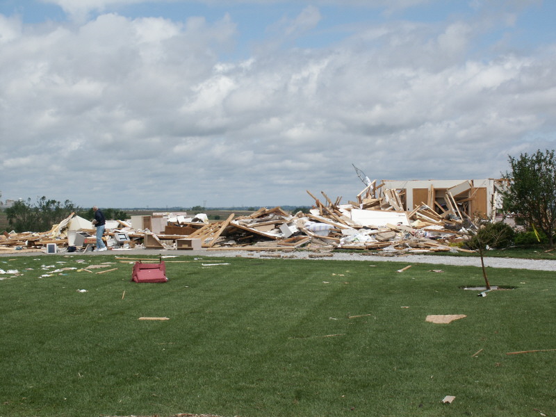
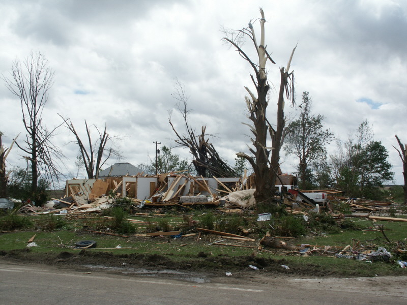
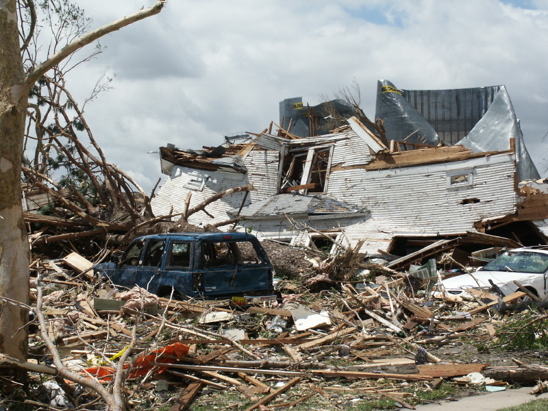
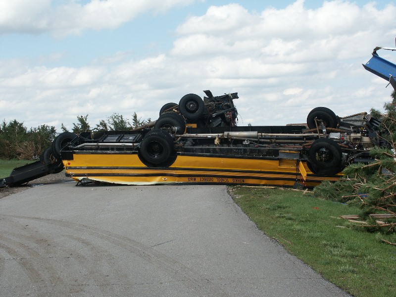
Storm Damage from Hallam
 |
 |
 |
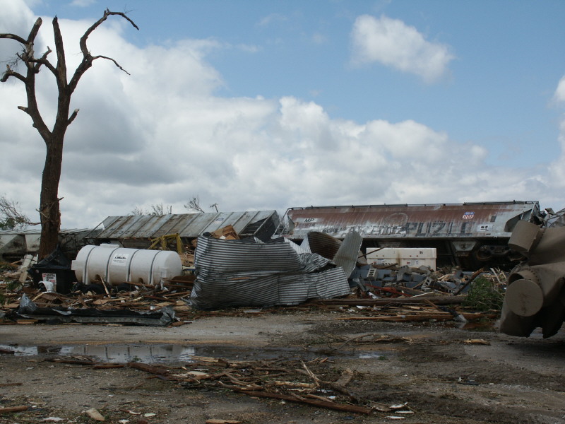 |
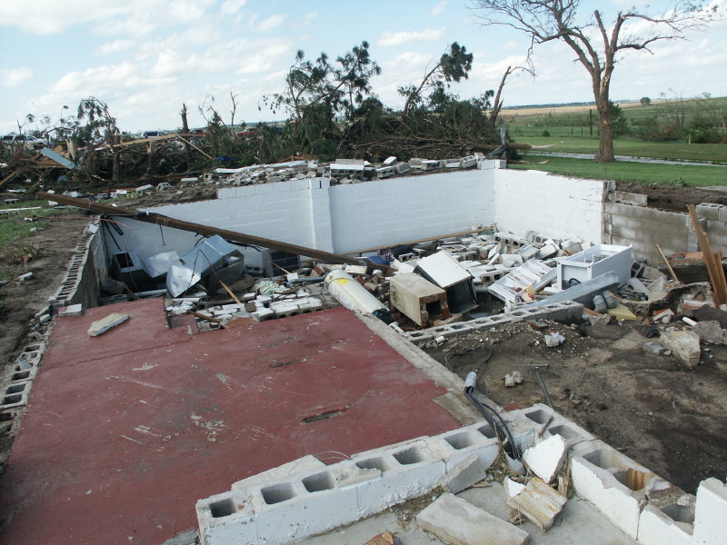
| Destroyed home on the east side of town. | A destroyed home and trees with all of their limbs gone. | Collapsed home | Toppled center flow hopper cars |
 |
 |
 |
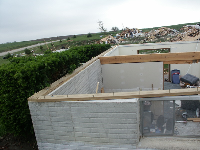 |
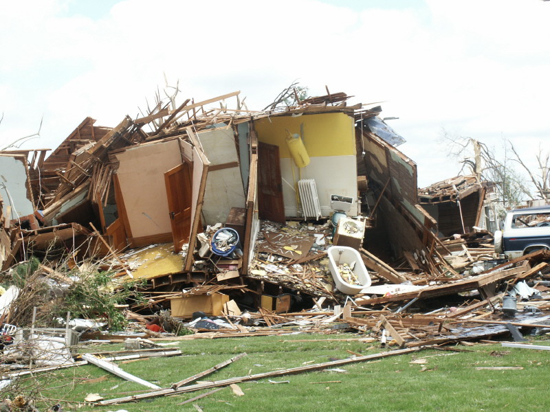
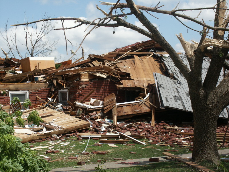
| All the rooms are exposed in this damaged home. | Collapsed remains of the United Methodist Church. | A 100 year old farm house swept away by the tornado north of Firth. The family that lived in this home just moved into it the week prior to the tornado. | Some of the strongest damage occurred south and west of town. |
 |
 |
 |
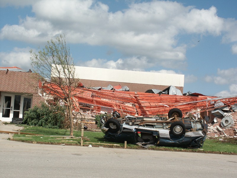 |
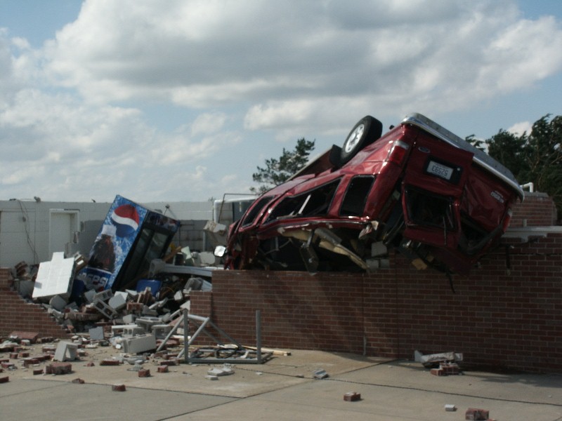
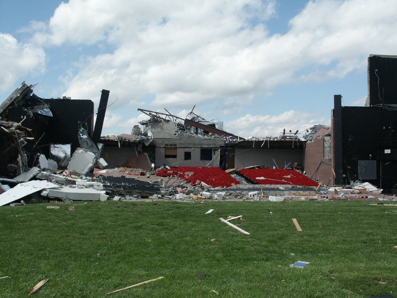
| Picture of a van that was thrown from the school bus area and landing on the remains of a concession building near the Norris school football field. | This is the remains of the auditorium of the Norris High School. The roof was peeled off and the walls collapsed into the auditorium. | School buses that were tossed like toys near the Norris school. | A mini van that was tossed and a roof of the school that collapsed at the Norris school. |
Damage Survey Report
A survey was conducted by the National Weather Service in Valley, NE of the tornado that struck Hallam on Saturday, May 22nd. The following is an overview of damage along the track.
The tornado started 2 miles north of Daykin, Nebraska and traveled east-northeast to about 1 mile south of western and continued to about 2 miles north of Swanton. The tornado was rated F0 to F1 on the Fujita damage scale. Much of the damage was due to farm outbuildings, grain bins and trees.
The tornado remained F0 to F1 until it struck the southern portions of Wilber where it strengthened to F2. Roofs blown off of homes occurred just southeast of Wilber. The tornado from Wilber to north of Clatonia to Hallam grew to its most intense stage. The tornado's path width also increased to an unprecedented two and one-half mile. The F-Scale rating for the storm was F4 from about Clatonia to Hallam. Many well-built homes were demolished. Grain bins, farm sheds and outbuildings and trees were demolished along this section of the path. Hallam itself escaped the strongest winds of the storm, which were south of the town. Nevertheless, many of the structures in Hallam were rated F2 to F3. The storm also toppled hopper cars from a freight train on the west side of the town. The tornado then tracked east for several miles prior to turning northeast again. The storm narrowed to about a mile wide as it passed just north of Cortland and about 2 miles north of Firth. The Norris schools north of Firth received severe damage with the roof of the middle school auditorium collapsed and several walls caved in. School busses were tossed. Several homes northeast of the schools were flattened where the storm was again rated F4. Damage continued northeast to Holland and 2 miles north of Panama. The tornado was slightly weaker in this section (F2 at the most) and began to narrow. The track then curved more to the north, just to the south of Bennet where some homes received F3 damage. After passing to the south of Bennet, the storm moved back to the northeast and began to weaken to F0 to F1 strength. The track also was becoming narrower. The tornado then dissipated 1 mile west of Palmyra.
Radar:
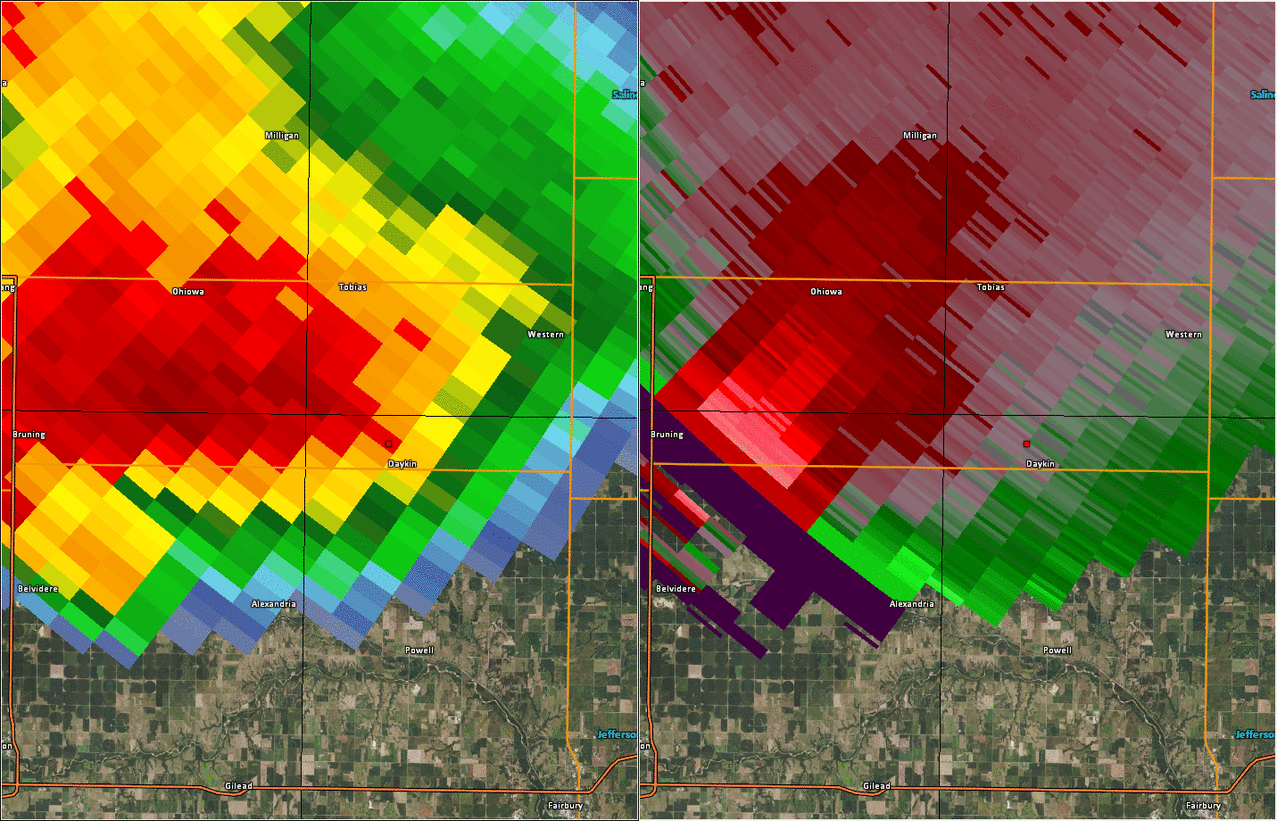
Reflectivity and Storm-Relative Velocity Data for the Hallam Tornado
 |
 |
 |
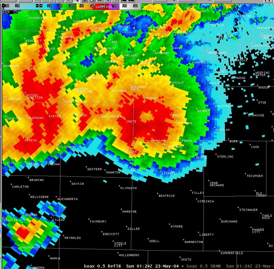 |
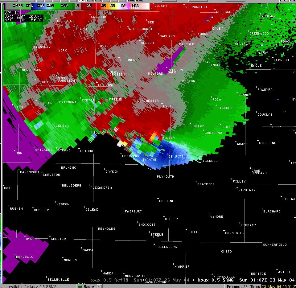
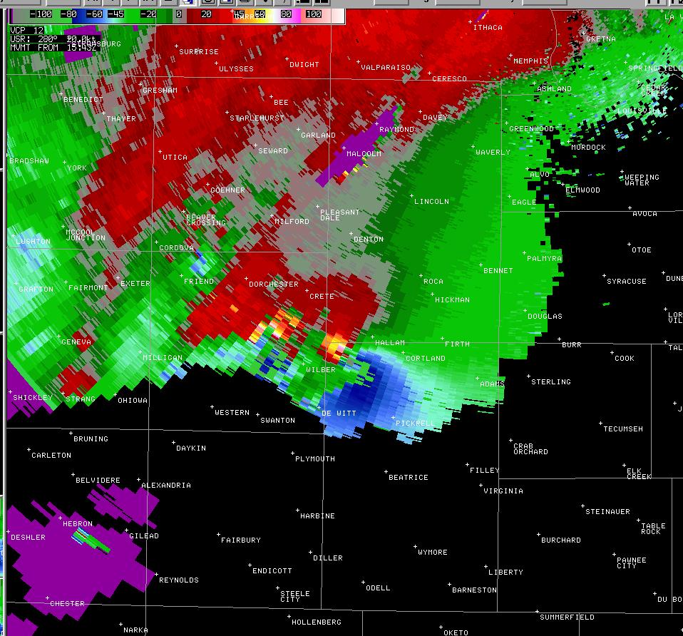
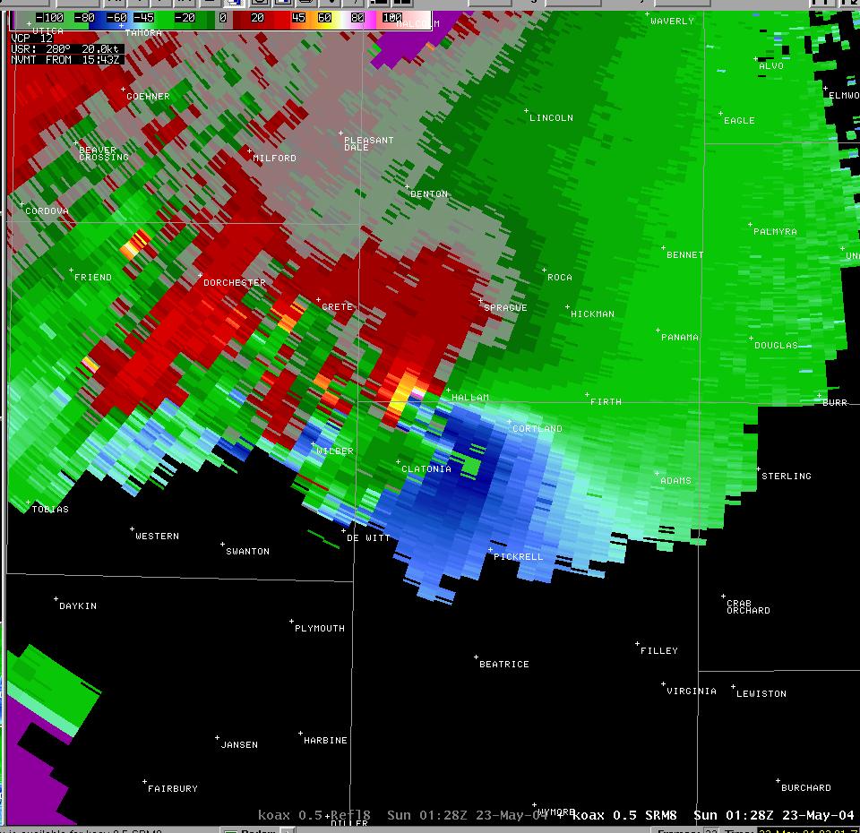
| Reflectivity and storm-relative velocity loop of the Hallam tornado. The loop is centered on the storm, so the background map is actually moving. | Reflectivity 01:07Z (8:07 PM CDT) This radar image shows the supercell as it was moving through Saline County. The red colors indicate very heavy rain or hail, with lighter rain indicated by the yellow, green, and blue colors. The tornado clipped the southern portion of the town of Wilber, with the main part of the tornado passing just south of Wilber. There is a hook echo that has completely wrapped around to form a "donut" shape echo between the towns of Wilber and De Witt. This donut echo is associated with the tornado. | Storm-Relative Velocity 01:07Z (8:07 CDT) This radar image shows the wind velocity within the supercell thunderstorm. The green and blue colors indicate winds blowing toward the radar, and the red, orange, and yellow colors indicate winds blowing away from the radar. Just southwest of Wilber the radar is showing a 105 mph wind blowing toward the radar, right next to a 69 mph wind blowing away from the radar. This is known as a "velocity couplet," and is often associated with the mesocyclone in the supercell. The radar typically does not actually measure the winds inside the tornado, but rather the "parent" mesocyclone that the tornado forms out of. | Reflecitivity 01:24Z (8:24 PM CDT) This reflectivity image shows a more classic looking hook echo, moving out of Saline County and into the northwest corner of Gage county and the southwest corner of Lancaster County. The hook echo, and the associated tornado, is between Hallam and Wilber. |
 |
 |
 |
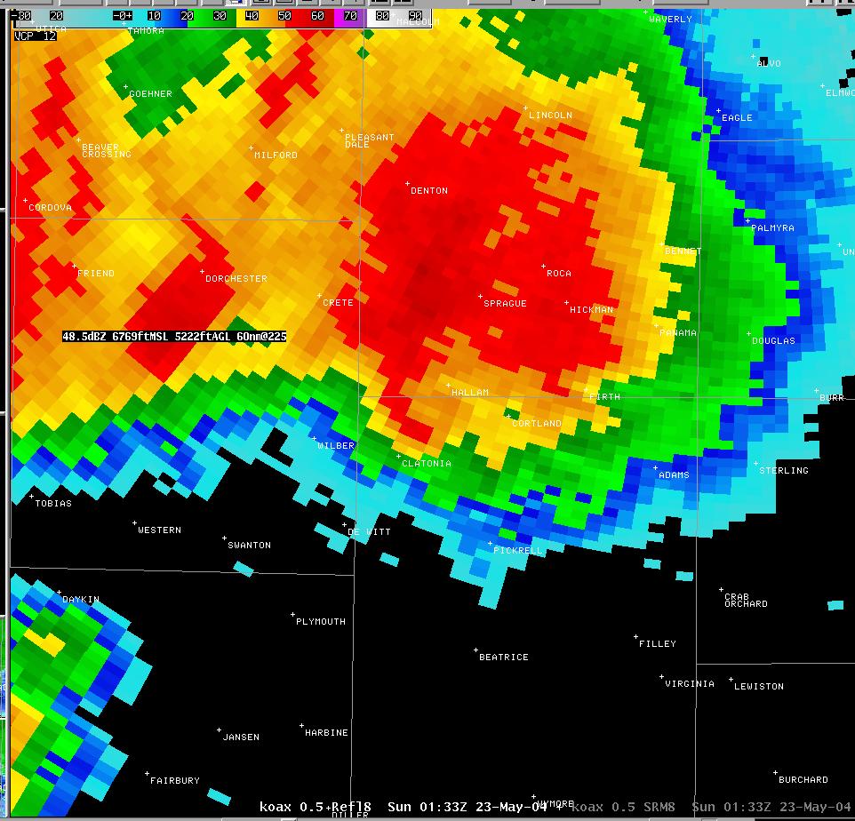 |
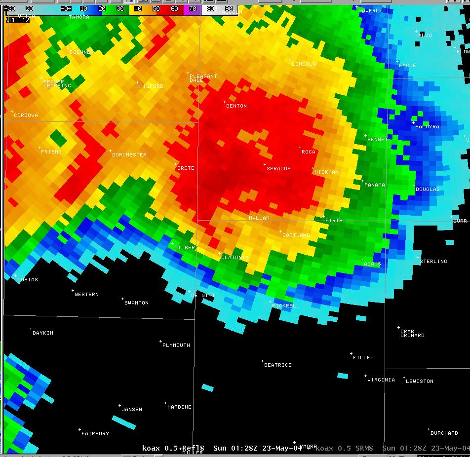
| Storm-Relative Velocity 01:24Z (8:24 CDT) At this time, the velocity image is showing winds of 90 mph blowing toward the radar, and 113 mph blowing away from the radar. | Reflectivity 01:28Z (8:28 PM CDT) The hook echo now stretches from the town of Claytonia to the town of Hallam. | Storm-Relative Velocity 01:28Z (8:28 CDT) The velocity couplet is shown just west of Hallam, about to move into the Hallam area. The wind speeds, as indicated by the radar, in the mesocyclone are 83 mph toward the radar and 100 mph away from the radar. | Reflectivity 01:33Z (8:33 PM CDT) The hook echo at 8:33 PM completely engulfed the town of Hallam. This was when the tornado was near its widest point of approximately 2 ½ miles. The town of Hallam was near the northern edge of the tornado path. |
 |
|||
| Storm-Relative Velocity 01:33Z (8:33 CDT) The tornado was passing over Hallam at 8:33 PM, and the radar velocity winds were 79 mph toward the radar and 92 mph away from the radar. Because the radar is measuring the winds in the mesocyclone, the wind speeds do not necessarily correlate to the strength of the tornado, because the tornado was rated a F4 at the time of this radar image. There are many factors and variables which determine the radar's ability to measure the wind speeds inside the mesocyclone. Despite the slightly lower winds on the radar, this is still considered an extremely strong velocity couplet. |
Storm Reports
NWUS53 KOAX 230426
LSROAX
PRELIMINARY LOCAL STORM REPORT
NATIONAL WEATHER SERVICE OMAHA NE
1126 PM CDT SAT MAY 22 2004
..TIME... ...EVENT... ...CITY LOCATION... ...LAT.LON...
..DATE... ....MAG.... ..COUNTY LOCATION...ST.. ...SOURCE....
..REMARKS..
1015 PM TSTM WND DMG 5 NW THURMAN 40.87N 95.82W
05/22/2004 FREMONT IA AMATEUR RADIO
RAILROAD CARS BLOWN OVER BUILDING ROOF BLOWN ONTO
HIGHWAY. I-29 MILE MARKER 20.
&&
$$
JB
000
NWUS53 KOAX 230419
LSROAX
PRELIMINARY LOCAL STORM REPORT
NATIONAL WEATHER SERVICE OMAHA NE
1119 PM CDT SAT MAY 22 2004
..TIME... ...EVENT... ...CITY LOCATION... ...LAT.LON...
..DATE... ....MAG.... ..COUNTY LOCATION...ST.. ...SOURCE....
..REMARKS..
1112 PM TSTM WND DMG 1 S HICKMAN 40.61N 96.63W
05/22/2004 LANCASTER NE AMATEUR RADIO
SOUTH OF HICKMAN GRAIN BINS BLOWN DOWN ACROSS ROADS AND
LIVESTOCK LOOSE IN NORRIS SCHOOL AREA.
&&
$$
JB
000
NWUS53 KOAX 230408 CCA
LSROAX
PRELIMINARY LOCAL STORM REPORT
NATIONAL WEATHER SERVICE OMAHA NE
1108 PM CDT SAT MAY 22 2004 ...2ND COR PLYMOUTH REPORT TIME...
..TIME... ...EVENT... ...CITY LOCATION... ...LAT.LON...
..DATE... ....MAG.... ..COUNTY LOCATION...ST.. ...SOURCE....
..REMARKS..
1022 PM HAIL ESE GLENWOOD 41.05N 95.74W
05/22/2004 1.00 INCH MILLS IA AMATEUR RADIO
1048 PM TORNADO 1 W PLYMOUTH 40.30N 97.01W
05/22/2004 JEFFERSON NE EMERGENCY MNGR
1024 PM HAIL 1 W PLYMOUTH 40.30N 97.01W
05/22/2004 1.00 INCH JEFFERSON NE EMERGENCY MNGR
DIME TO QUARTER SIZE HAIL FROM 4 NORTH OF FAIRBURY TO 3
WEST OF FAIRBURY
&&
$$
JB/TL
000
NWUS53 KOAX 230407 CCA
LSROAX
PRELIMINARY LOCAL STORM REPORT
NATIONAL WEATHER SERVICE OMAHA NE
1107 PM CDT SAT MAY 22 2004 ...COR PLYMOUTH REPORT TIME...
..TIME... ...EVENT... ...CITY LOCATION... ...LAT.LON...
..DATE... ....MAG.... ..COUNTY LOCATION...ST.. ...SOURCE....
..REMARKS..
1022 PM HAIL ESE GLENWOOD 41.05N 95.74W
05/22/2004 1.00 INCH MILLS IA AMATEUR RADIO
1155 PM TORNADO 1 W PLYMOUTH 40.30N 97.01W
05/22/2004 JEFFERSON NE EMERGENCY MNGR
1024 PM HAIL 1 W PLYMOUTH 40.30N 97.01W
05/22/2004 1.00 INCH JEFFERSON NE EMERGENCY MNGR
DIME TO QUARTER SIZE HAIL FROM 4 NORTH OF FAIRBURY TO 3
WEST OF FAIRBURY
&&
$$
JB/TL
000
NWUS53 KOAX 230406
LSROAX
PRELIMINARY LOCAL STORM REPORT
NATIONAL WEATHER SERVICE OMAHA NE
1106 PM CDT SAT MAY 22 2004
..TIME... ...EVENT... ...CITY LOCATION... ...LAT.LON...
..DATE... ....MAG.... ..COUNTY LOCATION...ST.. ...SOURCE....
..REMARKS..
1102 PM TORNADO 7 W BEATRICE 40.27N 96.88W
05/22/2004 GAGE NE EMERGENCY MNGR
&&
$$
JB
000
NWUS53 KOAX 230402
LSROAX
PRELIMINARY LOCAL STORM REPORT
NATIONAL WEATHER SERVICE OMAHA NE
1101 PM CDT SAT MAY 22 2004
..TIME... ...EVENT... ...CITY LOCATION... ...LAT.LON...
..DATE... ....MAG.... ..COUNTY LOCATION...ST.. ...SOURCE....
..REMARKS..
1045 PM TSTM WND DMG LINCOLN 40.82N 96.69W
05/22/2004 LANCASTER NE AMATEUR RADIO
SEVERAL HOMES DESTROYED AT 56TH AND OLIVE CREEK ROAD.
&&
$$
JB
000
NWUS53 KOAX 230356
LSROAX
PRELIMINARY LOCAL STORM REPORT
NATIONAL WEATHER SERVICE OMAHA NE
1056 PM CDT SAT MAY 22 2004
..TIME... ...EVENT... ...CITY LOCATION... ...LAT.LON...
..DATE... ....MAG.... ..COUNTY LOCATION...ST.. ...SOURCE....
..REMARKS..
1050 PM HAIL SWANTON 40.38N 97.08W
05/22/2004 1.00 INCH SALINE NE EMERGENCY MNGR
1043 PM TSTM WND DMG CLARINDA 40.74N 95.04W
05/22/2004 PAGE IA AMATEUR RADIO
GRAIN BIN BLOWN IN ROAD POWER LINE DAMAGE.
&&
$$
JB
000
NWUS53 KOAX 230354
LSROAX
PRELIMINARY LOCAL STORM REPORT
NATIONAL WEATHER SERVICE OMAHA NE
1053 PM CDT SAT MAY 22 2004
..TIME... ...EVENT... ...CITY LOCATION... ...LAT.LON...
..DATE... ....MAG.... ..COUNTY LOCATION...ST.. ...SOURCE....
..REMARKS..
1022 PM HAIL ESE GLENWOOD 41.05N 95.74W
05/22/2004 1.00 INCH MILLS IA AMATEUR RADIO
1024 PM TORNADO 1 W PLYMOUTH 40.30N 97.01W
05/22/2004 JEFFERSON NE EMERGENCY MNGR
1024 PM HAIL 1 W PLYMOUTH 40.30N 97.01W
05/22/2004 1.00 INCH JEFFERSON NE EMERGENCY MNGR
DIME TO QUARTER SIZE HAIL FROM 4 NORTH OF FAIRBURY TO 3
WEST OF FAIRBURY
&&
$$
JB
000
NWUS53 KOAX 230347
LSROAX
PRELIMINARY LOCAL STORM REPORT
NATIONAL WEATHER SERVICE OMAHA NE
1045 PM CDT SAT MAY 22 2004
..TIME... ...EVENT... ...CITY LOCATION... ...LAT.LON...
..DATE... ....MAG.... ..COUNTY LOCATION...ST.. ...SOURCE....
..REMARKS..
1017 PM HAIL 1 SW GLENWOOD 41.04N 95.76W
05/22/2004 0.75 INCH MILLS IA AMATEUR RADIO
1022 PM HAIL GLENWOOD 41.05N 95.74W
05/22/2004 1.00 INCH MILLS IA AMATEUR RADIO
1020 PM HAIL 2 E GLENWOOD 41.05N 95.70W
05/22/2004 0.75 INCH MILLS IA AMATEUR RADIO
1015 PM TSTM WND DMG 5 N THURMAN 40.89N 95.75W
05/22/2004 FREMONT IA AMATEUR RADIO
80 TO 100 MPH WINDS. SEMI BLOWN OVER ON I-29 MILE MARKER
23 NEAR BARTLETT IOWA. 5,000 TO 10,000 DAMAGE.
1036 PM TSTM WND GST 8 N FAIRBURY 40.26N 97.18W
05/22/2004 60 MPH JEFFERSON NE EMERGENCY MNGR
1036 PM TSTM WND GST 8 N FAIRBURY 40.26N 97.18W
05/22/2004 60 MPH JEFFERSON NE EMERGENCY MNGR
&&
$$
JB
000
NWUS53 KOAX 230336
LSROAX
PRELIMINARY LOCAL STORM REPORT
NATIONAL WEATHER SERVICE OMAHA NE
1034 PM CDT SAT MAY 22 2004
..TIME... ...EVENT... ...CITY LOCATION... ...LAT.LON...
..DATE... ....MAG.... ..COUNTY LOCATION...ST.. ...SOURCE....
..REMARKS..
1010 PM TSTM WND GST UNION 40.81N 95.92W
05/22/2004 80 MPH CASS NE AMATEUR RADIO
TREES DOWN AND POWER OUT IN UNION.
1000 PM FLOOD MADISON 41.83N 97.46W
05/22/2004 MADISON NE EMERGENCY MNGR
HIGHWAY 32 EAST CLOSED
1000 PM TSTM WND DMG MURDOCK 40.93N 96.28W
05/22/2004 CASS NE PUBLIC
TREES DOWN AND POWER LINES DOWN
1005 PM FLOOD DODGE 41.72N 96.88W
05/22/2004 DODGE NE FIRE DEPT/RESCUE
MAJOR FLOODING IN CITY OF DODGE SPUR 27A IS UNDER WATER.
1012 PM TSTM WND DMG FIRTH 40.53N 96.60W
05/22/2004 LANCASTER NE AMATEUR RADIO
ENTIRE TOWN OF FIRTH BLOCKED OFF WITH DEBRIS, UPROOTED
TREES AND BUILDINGS.
&&
$$
JB
000
NWUS53 KOAX 230319
LSROAX
PRELIMINARY LOCAL STORM REPORT
NATIONAL WEATHER SERVICE OMAHA NE
1018 PM CDT SAT MAY 22 2004
..TIME... ...EVENT... ...CITY LOCATION... ...LAT.LON...
..DATE... ....MAG.... ..COUNTY LOCATION...ST.. ...SOURCE....
..REMARKS..
0930 PM FLOOD DORCHESTER 40.65N 97.11W
05/22/2004 SALINE NE EMERGENCY MNGR
LOCAL FLOODING REPORTED
&&
$$
JB
000
NWUS53 KOAX 230317
LSROAX
PRELIMINARY LOCAL STORM REPORT
NATIONAL WEATHER SERVICE OMAHA NE
1017 PM CDT SAT MAY 22 2004
..TIME... ...EVENT... ...CITY LOCATION... ...LAT.LON...
..DATE... ....MAG.... ..COUNTY LOCATION...ST.. ...SOURCE....
..REMARKS..
1000 PM TORNADO 3 NE MURRAY 40.95N 95.89W
05/22/2004 CASS NE TRAINED SPOTTER
&&
$$
JB
000
NWUS53 KOAX 230315
LSROAX
PRELIMINARY LOCAL STORM REPORT
NATIONAL WEATHER SERVICE OMAHA NE
1015 PM CDT SAT MAY 22 2004
..TIME... ...EVENT... ...CITY LOCATION... ...LAT.LON...
..DATE... ....MAG.... ..COUNTY LOCATION...ST.. ...SOURCE....
..REMARKS..
1004 PM HAIL UNION 40.81N 95.92W
05/22/2004 1.00 INCH CASS NE AMATEUR RADIO
&&
$$
JB
000
NWUS53 KOAX 230310
LSROAX
PRELIMINARY LOCAL STORM REPORT
NATIONAL WEATHER SERVICE OMAHA NE
1010 PM CDT SAT MAY 22 2004
..TIME... ...EVENT... ...CITY LOCATION... ...LAT.LON...
..DATE... ....MAG.... ..COUNTY LOCATION...ST.. ...SOURCE....
..REMARKS..
0955 PM HAIL WILBER 40.48N 96.96W
05/22/2004 0.75 INCH SALINE NE EMERGENCY MNGR
&&
$$
JB
000
NWUS53 KOAX 230308
LSROAX
PRELIMINARY LOCAL STORM REPORT
NATIONAL WEATHER SERVICE OMAHA NE
1007 PM CDT SAT MAY 22 2004
..TIME... ...EVENT... ...CITY LOCATION... ...LAT.LON...
..DATE... ....MAG.... ..COUNTY LOCATION...ST.. ...SOURCE....
..REMARKS..
1005 PM HAIL 1 S NEBRASKA CITY 40.66N 95.86W
05/22/2004 1.00 INCH OTOE NE LAW ENFORCEMENT
&&
$$
JB
000
NWUS53 KOAX 230303
LSROAX
PRELIMINARY LOCAL STORM REPORT
NATIONAL WEATHER SERVICE OMAHA NE
1003 PM CDT SAT MAY 22 2004
..TIME... ...EVENT... ...CITY LOCATION... ...LAT.LON...
..DATE... ....MAG.... ..COUNTY LOCATION...ST.. ...SOURCE....
..REMARKS..
0957 PM TSTM WND GST UNION 40.81N 95.92W
05/22/2004 80 MPH CASS NE AMATEUR RADIO
&&
$$
JB
000
NWUS53 KOAX 230302
LSROAX
PRELIMINARY LOCAL STORM REPORT
NATIONAL WEATHER SERVICE OMAHA NE
1001 PM CDT SAT MAY 22 2004
..TIME... ...EVENT... ...CITY LOCATION... ...LAT.LON...
..DATE... ....MAG.... ..COUNTY LOCATION...ST.. ...SOURCE....
..REMARKS..
0957 PM HAIL UNION 40.81N 95.92W
05/22/2004 0.88 INCH CASS NE AMATEUR RADIO
&&
$$
JB
000
NWUS53 KOAX 230259
LSROAX
PRELIMINARY LOCAL STORM REPORT
NATIONAL WEATHER SERVICE OMAHA NE
959 PM CDT SAT MAY 22 2004
..TIME... ...EVENT... ...CITY LOCATION... ...LAT.LON...
..DATE... ....MAG.... ..COUNTY LOCATION...ST.. ...SOURCE....
..REMARKS..
0954 PM FUNNEL CLOUD 1 SW SWANTON 40.37N 97.09W
05/22/2004 SALINE NE EMERGENCY MNGR
&&
$$
JB
000
NWUS53 KOAX 230257
LSROAX
PRELIMINARY LOCAL STORM REPORT
NATIONAL WEATHER SERVICE OMAHA NE
956 PM CDT SAT MAY 22 2004
..TIME... ...EVENT... ...CITY LOCATION... ...LAT.LON...
..DATE... ....MAG.... ..COUNTY LOCATION...ST.. ...SOURCE....
..REMARKS..
0954 PM TSTM WND GST 6 W UNION 40.81N 96.04W
05/22/2004 60 MPH CASS NE AMATEUR RADIO
&&
$$
JB
000
NWUS53 KOAX 230254
LSROAX
PRELIMINARY LOCAL STORM REPORT
NATIONAL WEATHER SERVICE OMAHA NE
953 PM CDT SAT MAY 22 2004
..TIME... ...EVENT... ...CITY LOCATION... ...LAT.LON...
..DATE... ....MAG.... ..COUNTY LOCATION...ST.. ...SOURCE....
..REMARKS..
0947 PM TORNADO 3 SW NEBRASKA CITY 40.65N 95.90W
05/22/2004 OTOE NE EMERGENCY MNGR
BRIEF TOUCHDOWN
&&
$$
JB
000
NWUS53 KOAX 230248
LSROAX
PRELIMINARY LOCAL STORM REPORT
NATIONAL WEATHER SERVICE OMAHA NE
948 PM CDT SAT MAY 22 2004
..TIME... ...EVENT... ...CITY LOCATION... ...LAT.LON...
..DATE... ....MAG.... ..COUNTY LOCATION...ST.. ...SOURCE....
..REMARKS..
0930 PM TORNADO HALLAM 40.54N 96.79W
05/22/2004 LANCASTER NE AMATEUR RADIO
SEVERAL HOUSES DESTROYED AND POWER LINES DOWN REQUESTING
A LOT OF HELP. MEDICAL CALL REQUESTED TO HALLAM NEBRASKA
AS MAJOR DAMAGE.
&&
$$
JB
000
NWUS53 KOAX 230239
LSROAX
PRELIMINARY LOCAL STORM REPORT
NATIONAL WEATHER SERVICE OMAHA NE
938 PM CDT SAT MAY 22 2004
..TIME... ...EVENT... ...CITY LOCATION... ...LAT.LON...
..DATE... ....MAG.... ..COUNTY LOCATION...ST.. ...SOURCE....
..REMARKS..
0935 PM TSTM WND DMG HICKMAN 40.62N 96.63W
05/22/2004 LANCASTER NE CO-OP OBSERVER
SHED DESTROYED
&&
$$
JB
000
NWUS53 KOAX 230237
LSROAX
PRELIMINARY LOCAL STORM REPORT
NATIONAL WEATHER SERVICE OMAHA NE
936 PM CDT SAT MAY 22 2004
..TIME... ...EVENT... ...CITY LOCATION... ...LAT.LON...
..DATE... ....MAG.... ..COUNTY LOCATION...ST.. ...SOURCE....
..REMARKS..
0914 PM TORNADO 1 NW DOUGLAS 40.60N 96.40W
05/22/2004 OTOE NE TRAINED SPOTTER
BRIEF TOUCHDOWN
&&
$$
JB
000
NWUS53 KOAX 230233
LSROAX
PRELIMINARY LOCAL STORM REPORT
NATIONAL WEATHER SERVICE OMAHA NE
932 PM CDT SAT MAY 22 2004
..TIME... ...EVENT... ...CITY LOCATION... ...LAT.LON...
..DATE... ....MAG.... ..COUNTY LOCATION...ST.. ...SOURCE....
..REMARKS..
0837 PM HAIL 4 SW WOODBINE 41.70N 95.76W
05/22/2004 0.88 INCH HARRISON IA AMATEUR RADIO
&&
$$
JB
000
NWUS53 KOAX 230228
LSROAX
PRELIMINARY LOCAL STORM REPORT
NATIONAL WEATHER SERVICE OMAHA NE
927 PM CDT SAT MAY 22 2004
..TIME... ...EVENT... ...CITY LOCATION... ...LAT.LON...
..DATE... ....MAG.... ..COUNTY LOCATION...ST.. ...SOURCE....
..REMARKS..
0858 PM TORNADO 1 N FIRTH 40.55N 96.60W
05/22/2004 LANCASTER NE AMATEUR RADIO
ONE MILE NORTH OF FIRTH WITH HEAVY DAMAGE
&&
$$
SK
000
NWUS53 KOAX 230226
LSROAX
PRELIMINARY LOCAL STORM REPORT
NATIONAL WEATHER SERVICE OMAHA NE
925 PM CDT SAT MAY 22 2004
..TIME... ...EVENT... ...CITY LOCATION... ...LAT.LON...
..DATE... ....MAG.... ..COUNTY LOCATION...ST.. ...SOURCE....
..REMARKS..
0900 PM FLOOD 3 N LOGAN 41.69N 95.79W
05/22/2004 HARRISON IA AMATEUR RADIO
LOWLAND FLOODING WATER OVER ROAD
&&
$$
SK
000
NWUS53 KOAX 230202
LSROAX
PRELIMINARY LOCAL STORM REPORT
NATIONAL WEATHER SERVICE OMAHA NE
901 PM CDT SAT MAY 22 2004
..TIME... ...EVENT... ...CITY LOCATION... ...LAT.LON...
..DATE... ....MAG.... ..COUNTY LOCATION...ST.. ...SOURCE....
..REMARKS..
0840 PM TSTM WND DMG 10 NW BEATRICE 40.37N 96.88W
05/22/2004 GAGE NE LAW ENFORCEMENT
HOUSES DAMAGED IN NORTHWEST GAGE C0UNTY.
0837 PM HAIL 4 SW WOODBINE 41.70N 95.76W
05/22/2004 0.88 INCH HARRISON IA AMATEUR RADIO
0830 PM TSTM WND GST 14 N BEATRICE 40.47N 96.75W
05/22/2004 60 MPH GAGE NE TRAINED SPOTTER
AT JUNCTION OF HIGHWAYS 77 AND 41.
0845 PM HAIL 3 NE NEOLA 41.48N 95.58W
05/22/2004 1.00 INCH POTTAWATTAMIE IA LAW ENFORCEMENT
0843 PM FLASH FLOOD 3 S LOGAN 41.60N 95.79W
05/22/2004 HARRISON IA AMATEUR RADIO
STREET FLOODING AND WATER OVER ROAD.
0848 PM TORNADO 3 S HARLAN 41.61N 95.33W
05/22/2004 SHELBY IA EMERGENCY MNGR
AT F-58 AND JUNIPER RD.
0852 PM TSTM WND GST 4 NE HALLAM 40.58N 96.73W
05/22/2004 80 MPH LANCASTER NE AMATEUR RADIO
TRACTOR TRAILER BLOWN OVER.
0807 PM HAIL MISSOURI VALLEY 41.56N 95.90W
05/22/2004 1.00 INCH HARRISON IA AMATEUR RADIO
0858 PM TORNADO LINCOLN 40.82N 96.69W
05/22/2004 LANCASTER NE AMATEUR RADIO
HIGHWAY 77 AND FIRTH ROAD. MAJOR DAMGE TO POWER LINES AND
TREES.
&&
$$
SK
000
NWUS53 KOAX 230130
LSROAX
PRELIMINARY LOCAL STORM REPORT
NATIONAL WEATHER SERVICE OMAHA NE
830 PM CDT SAT MAY 22 2004
..TIME... ...EVENT... ...CITY LOCATION... ...LAT.LON...
..DATE... ....MAG.... ..COUNTY LOCATION...ST.. ...SOURCE....
..REMARKS..
0820 PM TSTM WND DMG FREMONT 41.44N 96.49W
05/22/2004 DODGE NE AMATEUR RADIO
A/C UNIT BLOWN OF WAL-MART. ALSO GAS LINES LEAKING.
&&
$$
SK
000
NWUS53 KOAX 230128
LSROAX
PRELIMINARY LOCAL STORM REPORT
NATIONAL WEATHER SERVICE OMAHA NE
828 PM CDT SAT MAY 22 2004
..TIME... ...EVENT... ...CITY LOCATION... ...LAT.LON...
..DATE... ....MAG.... ..COUNTY LOCATION...ST.. ...SOURCE....
..REMARKS..
0819 PM TORNADO 6 SW UNDERWOOD 41.32N 95.76W
05/22/2004 POTTAWATTAMIE IA STORM CHASER
&&
$$
SK
000
NWUS53 KOAX 230126
LSROAX
PRELIMINARY LOCAL STORM REPORT
NATIONAL WEATHER SERVICE OMAHA NE
825 PM CDT SAT MAY 22 2004
..TIME... ...EVENT... ...CITY LOCATION... ...LAT.LON...
..DATE... ....MAG.... ..COUNTY LOCATION...ST.. ...SOURCE....
..REMARKS..
0809 PM HAIL BLAIR 41.54N 96.14W
05/22/2004 2.00 INCH WASHINGTON NE AMATEUR RADIO
&&
$$
SK
000
NWUS53 KOAX 230124
LSROAX
PRELIMINARY LOCAL STORM REPORT
NATIONAL WEATHER SERVICE OMAHA NE
824 PM CDT SAT MAY 22 2004
..TIME... ...EVENT... ...CITY LOCATION... ...LAT.LON...
..DATE... ....MAG.... ..COUNTY LOCATION...ST.. ...SOURCE....
..REMARKS..
0815 PM TSTM WND DMG WILBER 40.48N 96.96W
05/22/2004 SALINE NE EMERGENCY MNGR
LOST POWER/EVACUATING EOC
&&
$$
SK
000
NWUS53 KOAX 230122
LSROAX
PRELIMINARY LOCAL STORM REPORT
NATIONAL WEATHER SERVICE OMAHA NE
822 PM CDT SAT MAY 22 2004
..TIME... ...EVENT... ...CITY LOCATION... ...LAT.LON...
..DATE... ....MAG.... ..COUNTY LOCATION...ST.. ...SOURCE....
..REMARKS..
0818 PM TSTM WND GST LINCOLN 40.82N 96.69W
05/22/2004 80 MPH LANCASTER NE AMATEUR RADIO
&&
$$
SK
000
NWUS53 KOAX 230119
LSROAX
PRELIMINARY LOCAL STORM REPORT
NATIONAL WEATHER SERVICE OMAHA NE
819 PM CDT SAT MAY 22 2004
..TIME... ...EVENT... ...CITY LOCATION... ...LAT.LON...
..DATE... ....MAG.... ..COUNTY LOCATION...ST.. ...SOURCE....
..REMARKS..
0809 PM HAIL 7 SW LOGAN 41.57N 95.89W
05/22/2004 0.75 INCH HARRISON IA AMATEUR RADIO
&&
$$
SK
000
NWUS53 KOAX 230111
LSROAX
PRELIMINARY LOCAL STORM REPORT
NATIONAL WEATHER SERVICE OMAHA NE
810 PM CDT SAT MAY 22 2004
..TIME... ...EVENT... ...CITY LOCATION... ...LAT.LON...
..DATE... ....MAG.... ..COUNTY LOCATION...ST.. ...SOURCE....
..REMARKS..
0802 PM HAIL 7 SW WOODBINE 41.66N 95.80W
05/22/2004 1.75 INCH HARRISON IA AMATEUR RADIO
0803 PM TSTM WND GST 6 SW WILBER 40.42N 97.04W
05/22/2004 50 MPH SALINE NE AMATEUR RADIO
0747 PM TORNADO 1 W WESTERN 40.39N 97.22W
05/22/2004 SALINE NE TRAINED SPOTTER
0808 PM TORNADO 6 SW WILBER 40.42N 97.04W
05/22/2004 SALINE NE AMATEUR RADIO
2ND FUNNEL DEVELOPING.
&&
$$
LANDSVORK
000
NWUS53 KOAX 230102
LSROAX
PRELIMINARY LOCAL STORM REPORT
NATIONAL WEATHER SERVICE OMAHA NE
801 PM CDT SAT MAY 22 2004
..TIME... ...EVENT... ...CITY LOCATION... ...LAT.LON...
..DATE... ....MAG.... ..COUNTY LOCATION...ST.. ...SOURCE....
..REMARKS..
0747 PM TORNADO 1 W WESTERN 40.39N 97.22W
05/22/2004 SALINE NE FIRE DEPT/RESCUE
0747 PM HAIL BLAIR 41.54N 96.14W
05/22/2004 1.75 INCH WASHINGTON NE TRAINED SPOTTER
0750 PM HAIL LOGAN 41.64N 95.79W
05/22/2004 1.75 INCH HARRISON IA AMATEUR RADIO
0751 PM TORNADO 1 NW SWANTON 40.39N 97.09W
05/22/2004 SALINE NE TRAINED SPOTTER
BASEBALL SIZE HAIL AND SEVERAL OTHER FUNNELS.
0757 PM HAIL LOGAN 41.64N 95.79W
05/22/2004 2.75 INCH HARRISON IA AMATEUR RADIO
0758 PM HAIL 1 NW SWANTON 40.39N 97.09W
05/22/2004 1.75 INCH SALINE NE EMERGENCY MNGR
WINDS DAMAGE FROM 60-70 MPH TSTM GUSTS.
&&
$$
LANDSVORK
000
NWUS53 KOAX 230045
LSROAX
PRELIMINARY LOCAL STORM REPORT
NATIONAL WEATHER SERVICE OMAHA NE
745 PM CDT SAT MAY 22 2004
..TIME... ...EVENT... ...CITY LOCATION... ...LAT.LON...
..DATE... ....MAG.... ..COUNTY LOCATION...ST.. ...SOURCE....
..REMARKS..
0740 PM TORNADO 3 NE DAYKIN 40.35N 97.26W
05/22/2004 SALINE NE NWS EMPLOYEE
&&
$$
LANDSVORK
000
NWUS53 KOAX 230044
LSROAX
PRELIMINARY LOCAL STORM REPORT
NATIONAL WEATHER SERVICE OMAHA NE
744 PM CDT SAT MAY 22 2004
..TIME... ...EVENT... ...CITY LOCATION... ...LAT.LON...
..DATE... ....MAG.... ..COUNTY LOCATION...ST.. ...SOURCE....
..REMARKS..
0735 PM HAIL 2 S BLAIR 41.52N 96.14W
05/22/2004 2.75 INCH WASHINGTON NE TRAINED SPOTTER
0736 PM TORNADO 2 W WESTERN 40.39N 97.24W
05/22/2004 SALINE NE EMERGENCY MNGR
&&
$$
LANDSVORK
000
NWUS53 KOAX 230036
LSROAX
PRELIMINARY LOCAL STORM REPORT
NATIONAL WEATHER SERVICE OMAHA NE
735 PM CDT SAT MAY 22 2004
..TIME... ...EVENT... ...CITY LOCATION... ...LAT.LON...
..DATE... ....MAG.... ..COUNTY LOCATION...ST.. ...SOURCE....
..REMARKS..
0704 PM FUNNEL CLOUD 5 SW TOBIAS 40.37N 97.40W
05/22/2004 FILLMORE NE TRAINED SPOTTER
0706 PM HAIL FREMONT 41.44N 96.49W
05/22/2004 0.88 INCH DODGE NE TRAINED SPOTTER
1 TO 2 INCH DIAMETER TREE LIMBS BLOWN OFF.
0710 PM TSTM WND GST FREMONT 41.44N 96.49W
05/22/2004 50 MPH DODGE NE TRAINED SPOTTER
0711 PM HAIL TOBIAS 40.42N 97.34W
05/22/2004 0.75 INCH SALINE NE FIRE DEPT/RESCUE
0715 PM HAIL 2 ESE FREMONT 41.43N 96.46W
05/22/2004 1.75 INCH DODGE NE EMERGENCY MNGR
WIND DAMAGE TO POWER PLOES FROM 70 MPH WIND GUST.
0710 PM TORNADO 9 N DAVID CITY 41.38N 97.13W
05/22/2004 COLFAX NE TRAINED SPOTTER
BRIEF TOUCHDOWN.
0610 PM TORNADO 6 N DAVID CITY 41.34N 97.13W
05/22/2004 BUTLER NE TRAINED SPOTTER
BRIEF TOUCHDOWN.
0710 PM NON-TSTM WND DMG FREMONT 41.44N 96.49W
05/22/2004 DODGE NE AMATEUR RADIO
POWER LINES DOWN, SOME STREET FLOODING.
0715 PM HAIL 4 E WINSLOW 41.61N 96.43W
05/22/2004 1.75 INCH WASHINGTON NE TRAINED SPOTTER
0725 PM FUNNEL CLOUD 4 S TOBIAS 40.36N 97.34W
05/22/2004 SALINE NE LAW ENFORCEMENT
0730 PM HAIL TOBIAS 40.42N 97.34W
05/22/2004 2.75 INCH SALINE NE FIRE DEPT/RESCUE
0731 PM HAIL 2 SW TOBIAS 40.40N 97.36W
05/22/2004 3.00 INCH FILLMORE NE EMERGENCY MNGR
&&
$$
LANDSVORK
000
NWUS53 KOAX 230009
LSROAX
PRELIMINARY LOCAL STORM REPORT
NATIONAL WEATHER SERVICE OMAHA NE
708 PM CDT SAT MAY 22 2004
..TIME... ...EVENT... ...CITY LOCATION... ...LAT.LON...
..DATE... ....MAG.... ..COUNTY LOCATION...ST.. ...SOURCE....
..REMARKS..
0701 PM TSTM WND GST FREMONT 41.44N 96.49W
05/22/2004 60 MPH DODGE NE AMATEUR RADIO
0701 PM HAIL WINSLOW 41.61N 96.50W
05/22/2004 1.75 INCH DODGE NE AMATEUR RADIO
0703 PM HAIL FREMONT 41.44N 96.49W
05/22/2004 2.75 INCH DODGE NE LAW ENFORCEMENT
0705 PM HAIL FREMONT 41.44N 96.49W
05/22/2004 1.00 INCH DODGE NE TRAINED SPOTTER
&&
$$
LANDSVORK
000
NWUS53 KOAX 230000
LSROAX
PRELIMINARY LOCAL STORM REPORT
NATIONAL WEATHER SERVICE OMAHA NE
659 PM CDT SAT MAY 22 2004
..TIME... ...EVENT... ...CITY LOCATION... ...LAT.LON...
..DATE... ....MAG.... ..COUNTY LOCATION...ST.. ...SOURCE....
..REMARKS..
0657 PM HAIL 1 NE NORTH BEND 41.48N 96.77W
05/22/2004 2.75 INCH DODGE NE AMATEUR RADIO
&&
$$
LANDSVORK
000
NWUS53 KOAX 222356
LSROAX
PRELIMINARY LOCAL STORM REPORT
NATIONAL WEATHER SERVICE OMAHA NE
656 PM CDT SAT MAY 22 2004
..TIME... ...EVENT... ...CITY LOCATION... ...LAT.LON...
..DATE... ....MAG.... ..COUNTY LOCATION...ST.. ...SOURCE....
..REMARKS..
0650 PM HAIL 6 W NORTH BEND 41.47N 96.90W
05/22/2004 1.75 INCH COLFAX NE AMATEUR RADIO
&&
$$
Environment
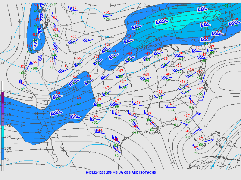
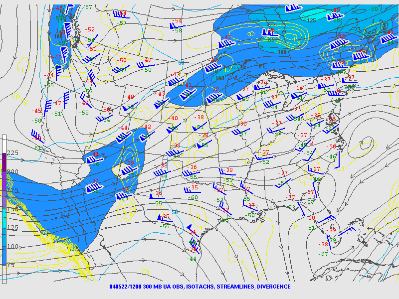
Synoptic Setup
 |
 |
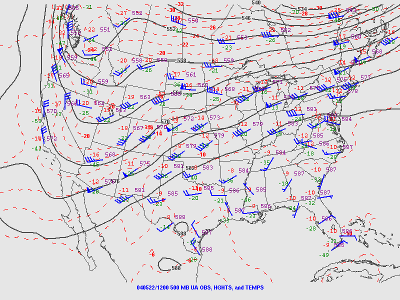 |
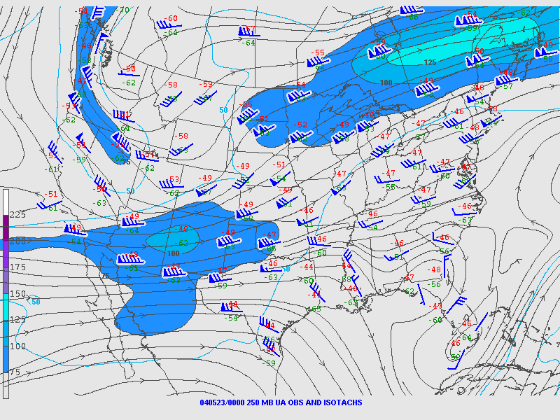
| Figure 1: 12z 250-mb analysis (SPC) | Figure 2: 12z 300-mb analysis (SPC) | Figure 3: 12z 500-mb analysis (SPC) |
 |
 |
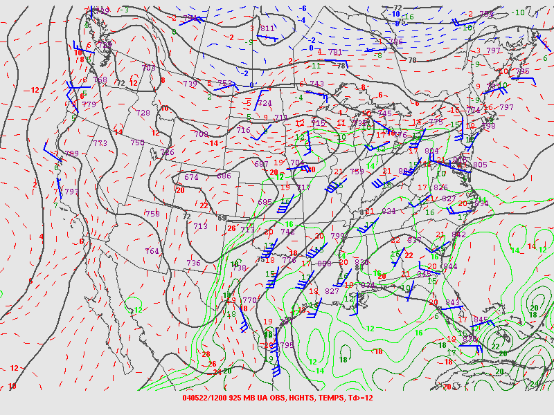 |
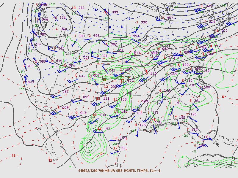
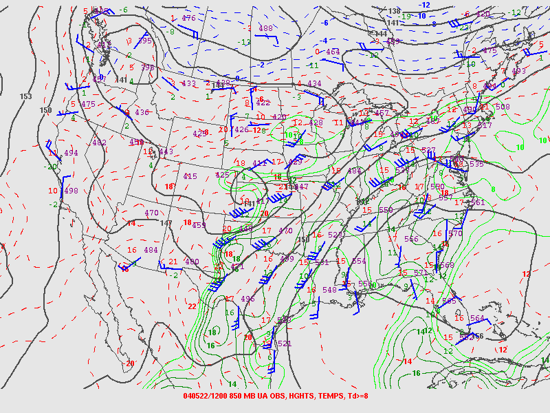
| Figure 4: 12z 700-mb analysis (SPC) | Figure 5: 12z 850-mb analysis (SPC) | Figure 6: 12z 925-mb analysis (SPC) |
 |
 |
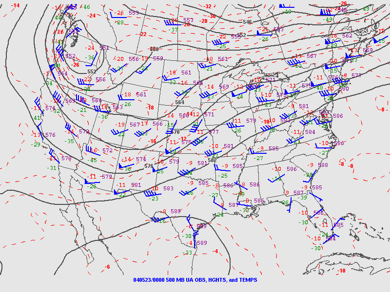 |
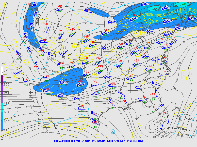
| Figure 7: 00z 250-mb analysis (SPC) | Figure 8: 00z 300-mb analysis (SPC) | Figure 9: 00z 500-mb analysis (SPC) |
 |
 |
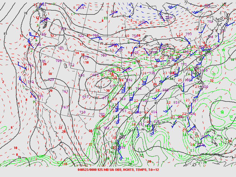 |
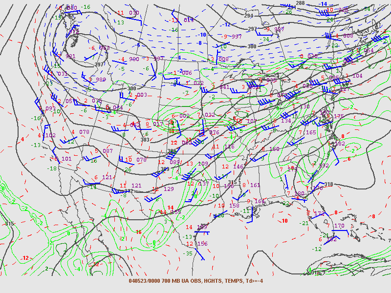
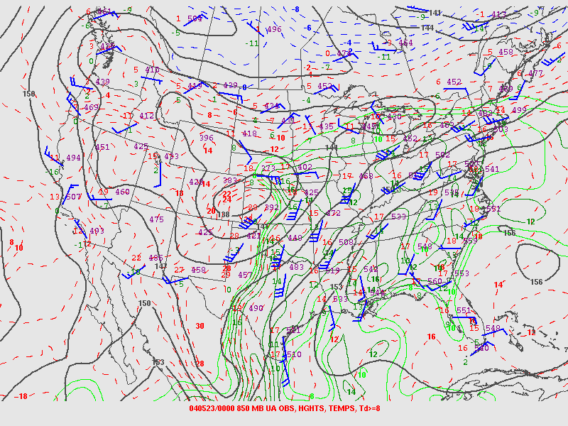
| Figure 10: 00z 700-mb analysis (SPC) | Figure 11: 00z 850-mb analysis (SPC) | Figure 12: 00z 925-mb analysis (SPC) |
 |
 |
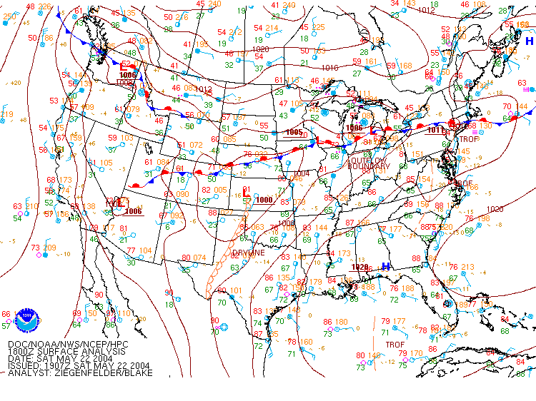 |
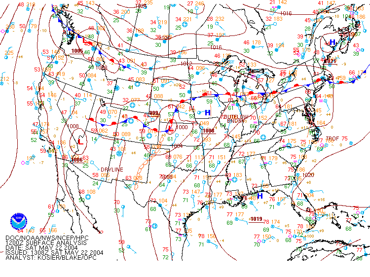
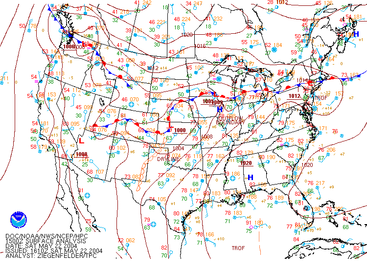
| Figure 13: 12z surface analysis (WPC) | Figure 14: 15z surface analysis (WPC) | Figure 15: 18z surface analysis (WPC) |
 |
 |
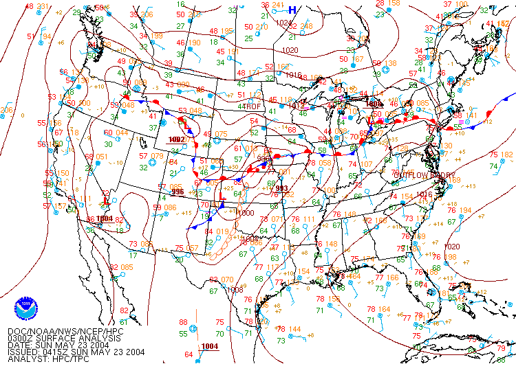 |
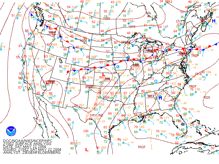
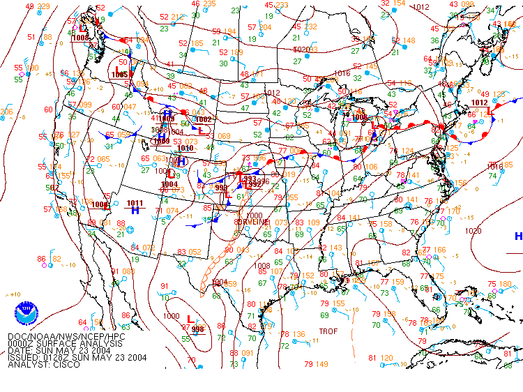
| Figure 16: 21z surface analysis (WPC) | Figure 17: 00z surface analysis (WPC) | Figure 18: 03z surface analysis (WPC) |
Mesoscale Environment
 |
 |
 |
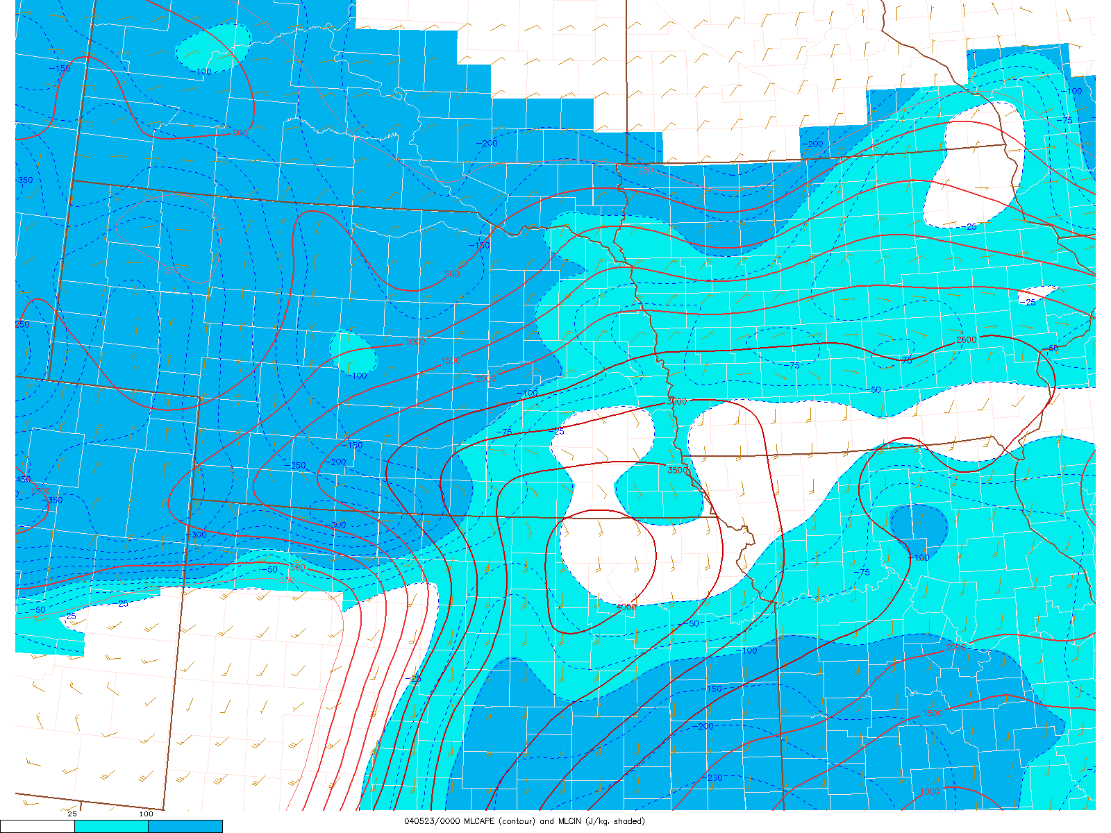
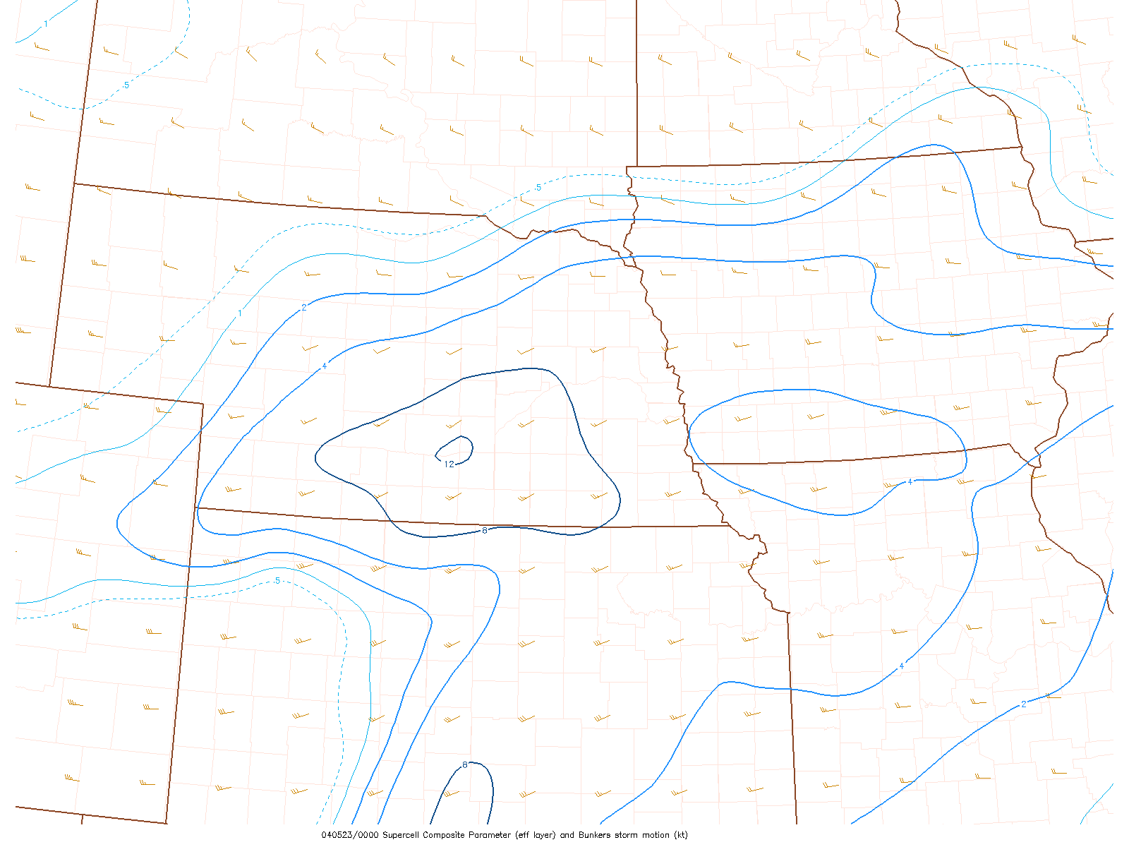
| Figure 19: 00z mlCAPE (SPC) | Figure 20: Supercell Composite Parameter (SPC) | Figure 21: Significant Tornado Parameter (SPC) |
 |
 |
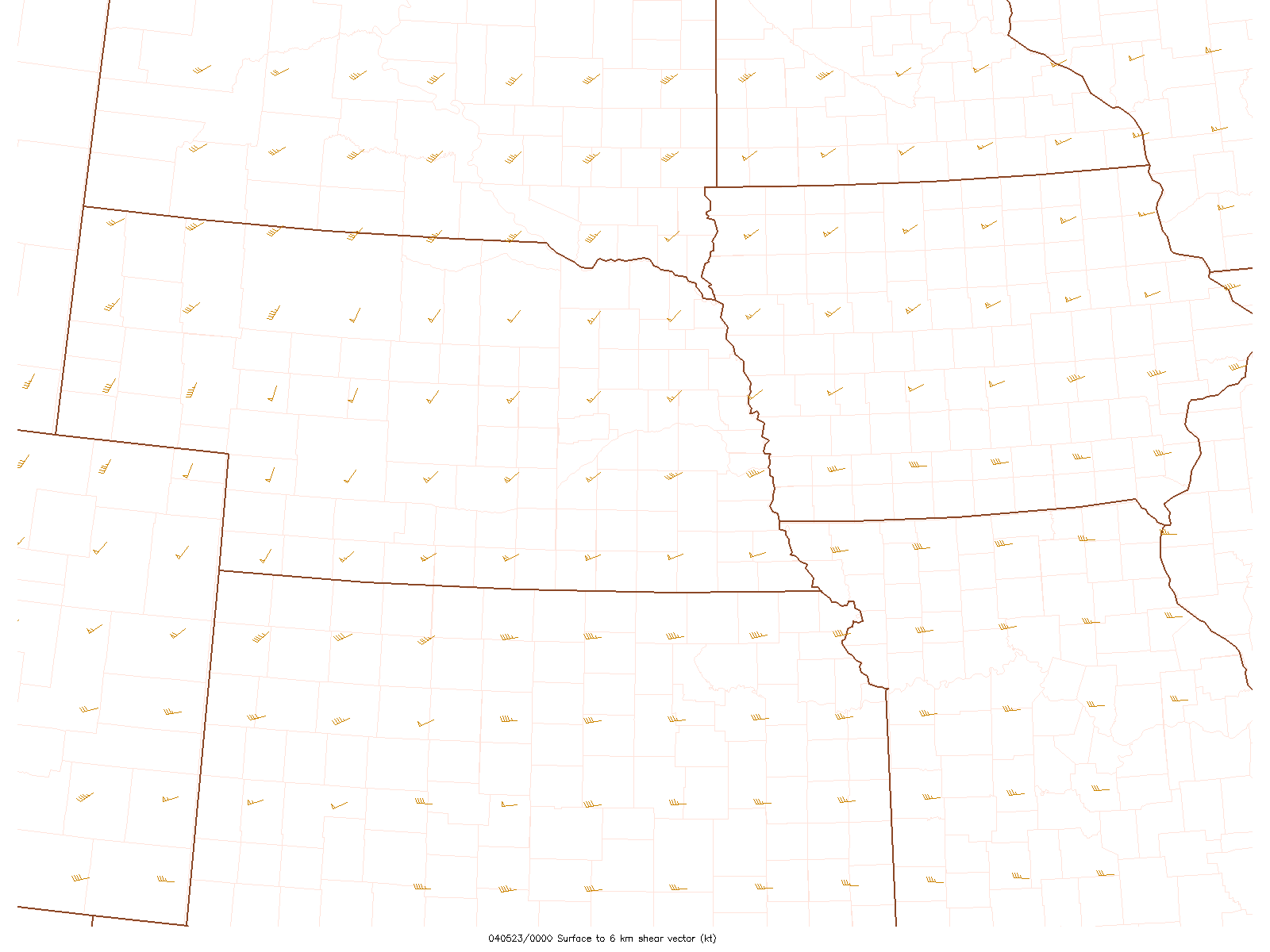 |
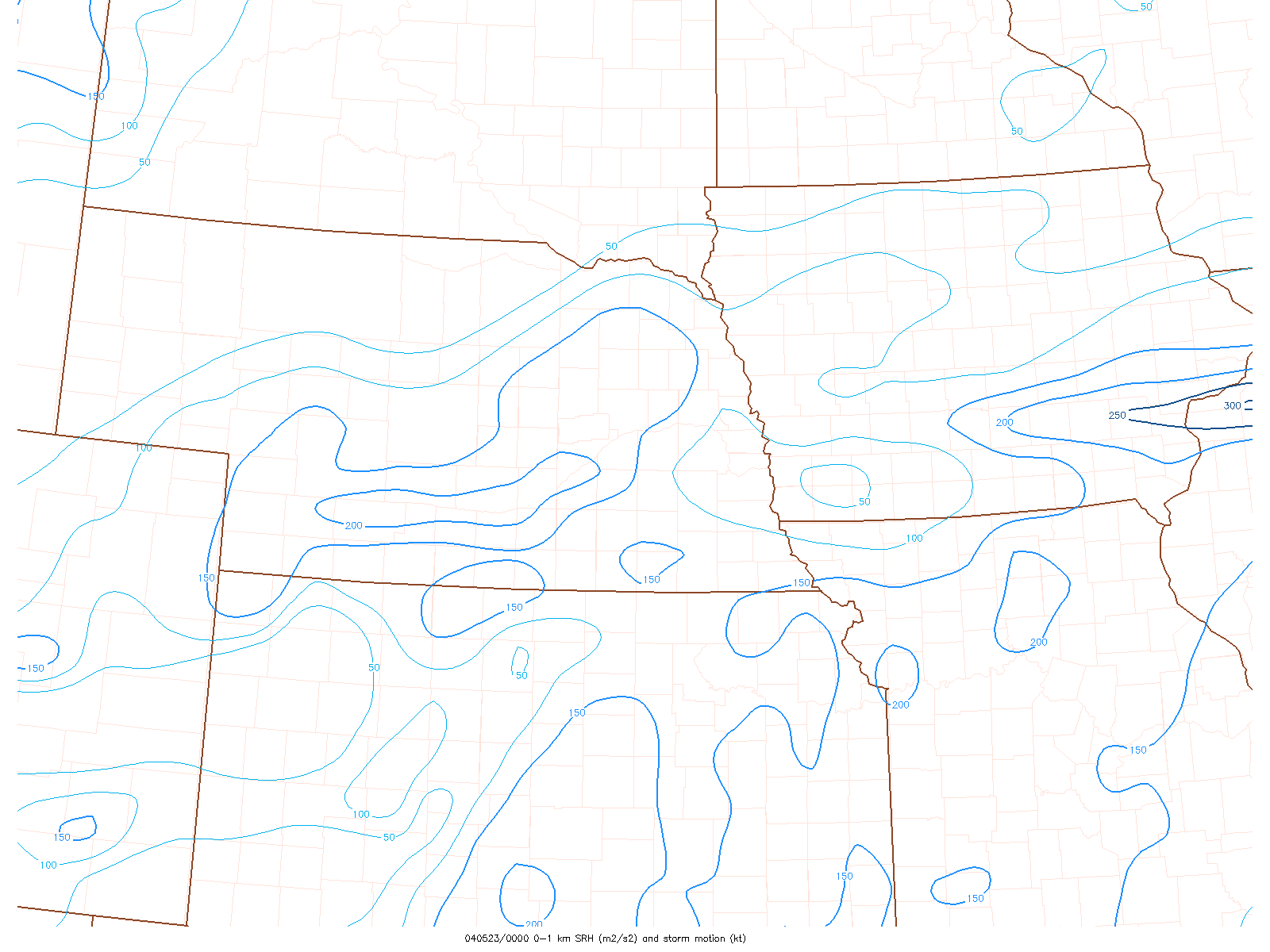
| Figure 22: 00z Effective Storm-Relative Helicity (SPC) | Figure 23: 00z 0-1-km Storm-Relative Helicity (SPC) | Figure 24: 00z 0-6-km Bulk Shear (SPC) |
 |
Media use of NWS Web News Stories is encouraged! Please acknowledge the NWS as the source of any news information accessed from this site. |
|

