Extreme heat continues today from the central Plains to the lower Mississippi River Valley, over southeast Montana, and from southern California into the Southwest Deserts. Extreme Heat Warnings remain in effect. Severe thunderstorms capable of strong to severe wind gusts and large hail are possible across the Great Lakes into the Ohio Valley today into tonight. Read More >
Overview
|
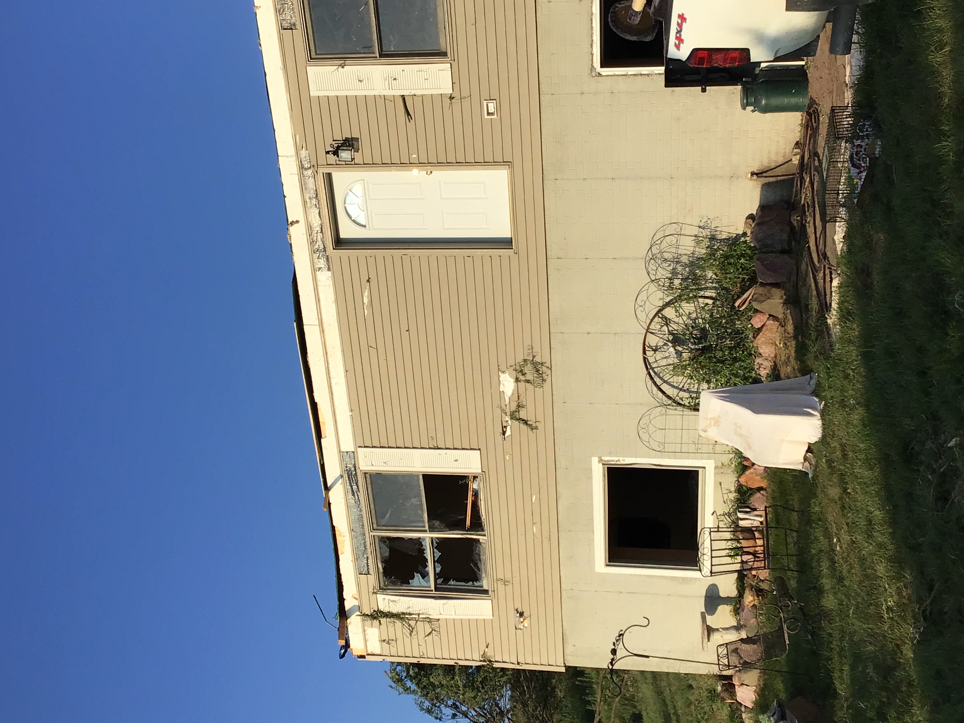
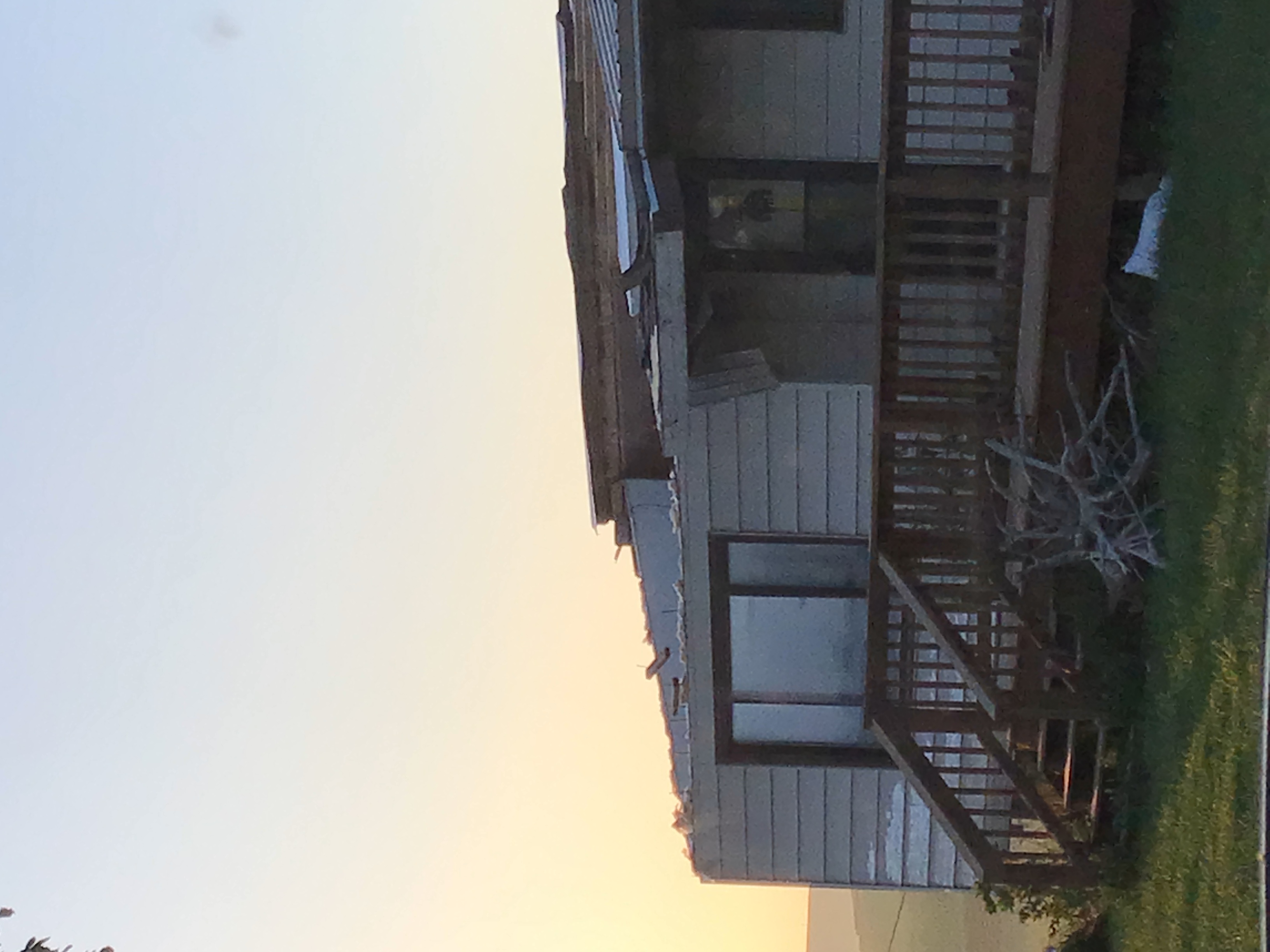
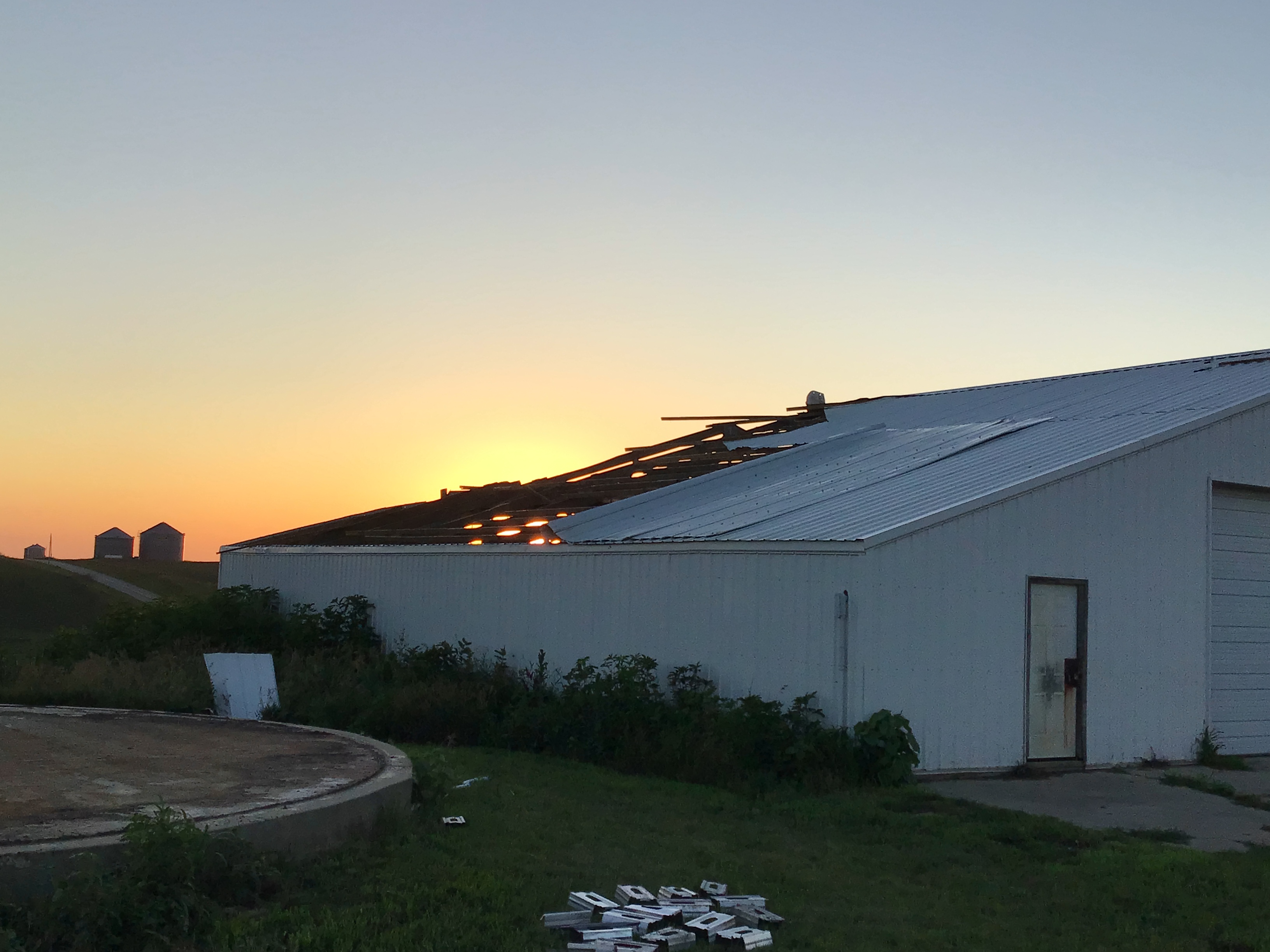
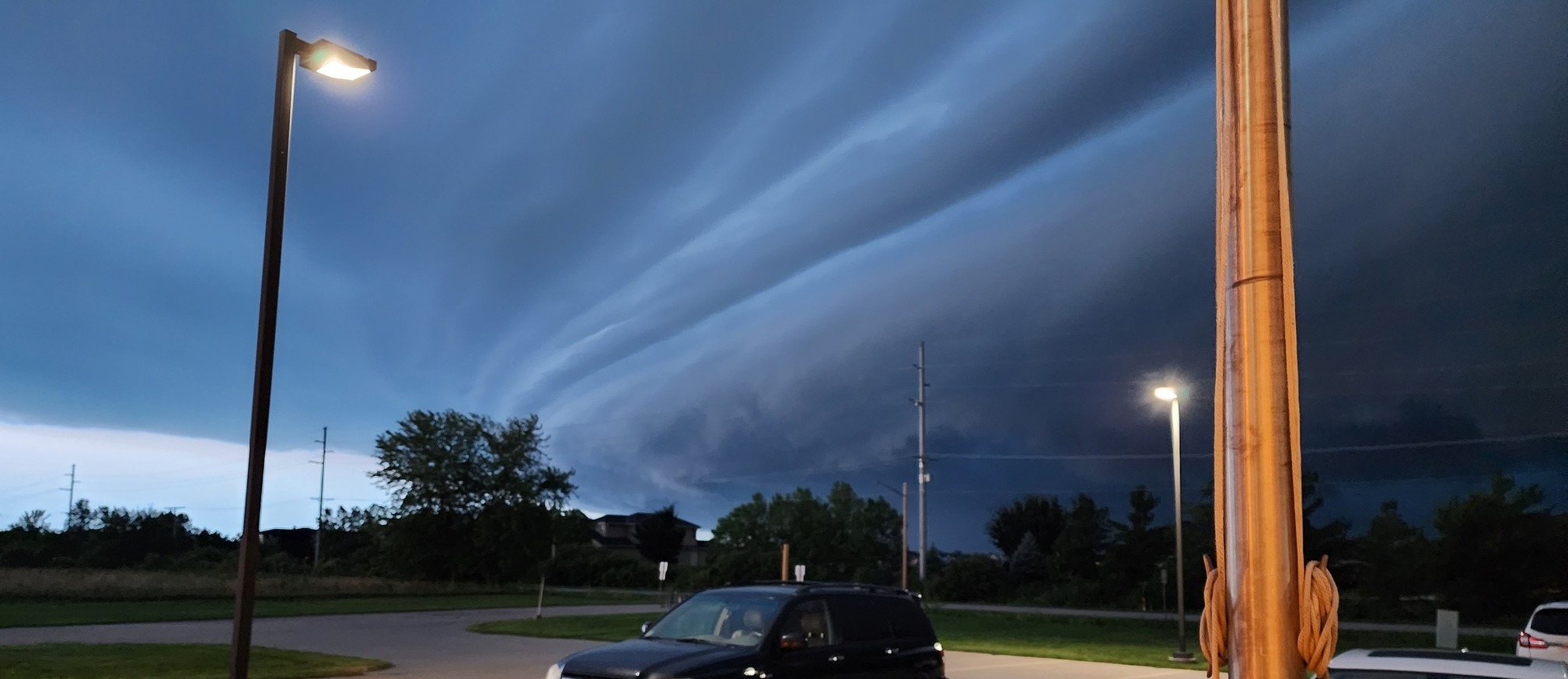
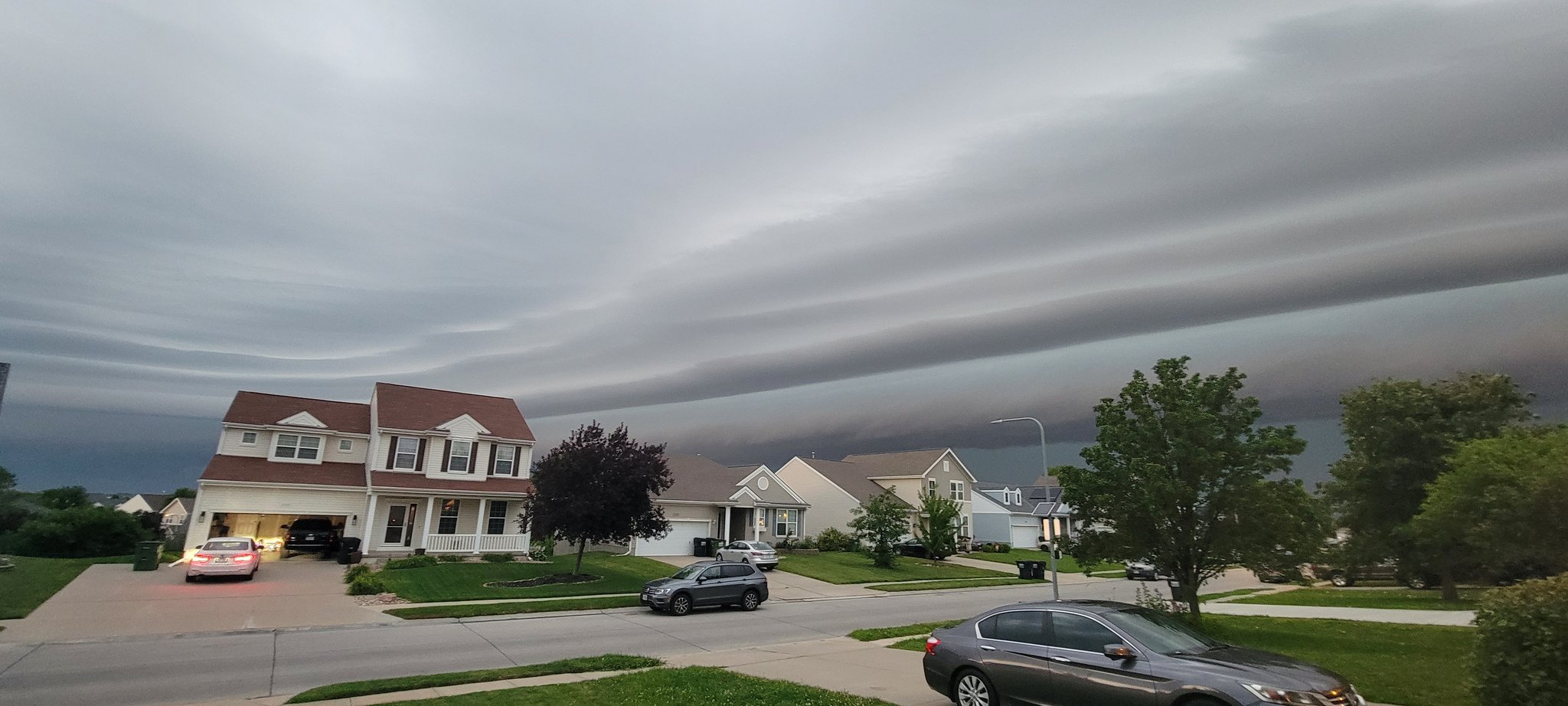
A widespread significant damaging wind storm tracked across nearly all of eastern Nebraska and western Iowa on the morning of July 12. These storms produced widespread winds of 60 to 80 mph, with embedded stronger downbursts with wind speeds up to 100 mph. The strongest measured wind gust was 82 mph in Dodge County NE, but some of the high-end straight line wind damage supports embedded wind speeds up to 100 mph. This storm also produced a few embedded tornadoes. One of the tornadoes in Harrison county was strong, rated an EF-2. 4 were rated EF-1, and 2 were rated EF-0. Some of the tornado tracks were only identified by narrow swaths of damage through mature cornfields, with minimal damage otherwise and peak wind speeds similar to the nearby downburst winds. All but one of the tornadoes was preceded by a Wireless Emergency Alert. There were 0 reported injuries or fatalities. |
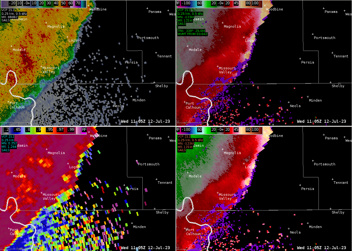
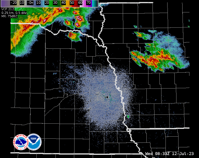 KOAX Radar Loop 7/12/2023 330 am to 730 am (0830 UTC to 1230 UTC) |
Tornadoes:
|
Tornado - Howells, NE
Track Map 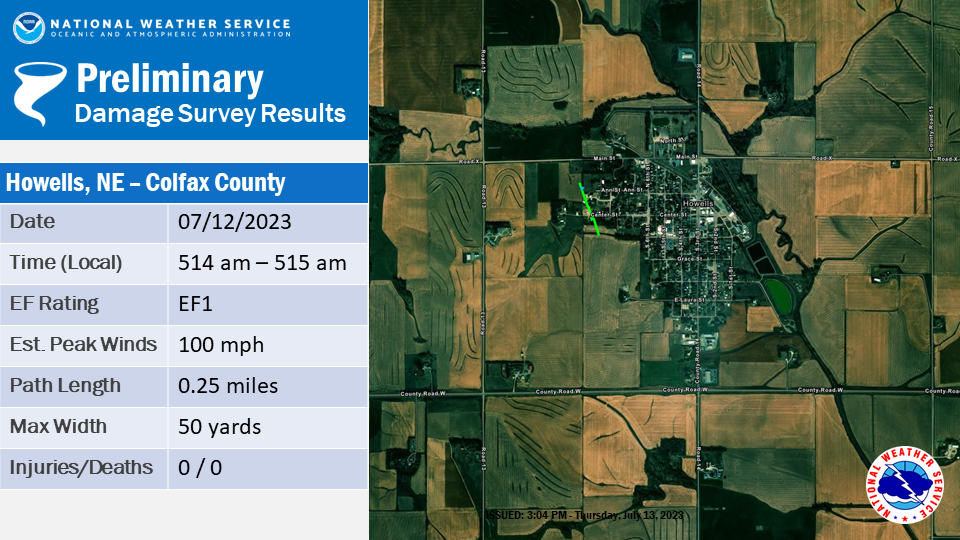 
|
||||||||||||||||
|
Tornado - Bancroft, NE
Track Map 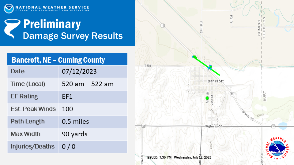
|
||||||||||||||||
|
Tornado - Tekamah, NE
Track Map 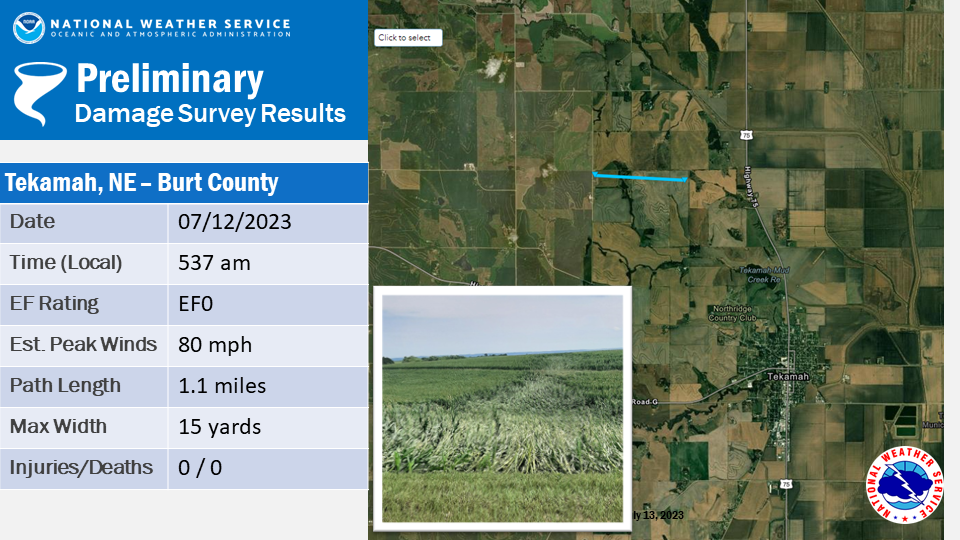
|
||||||||||||||||
|
Tornado - Central Harrison County
Track Map 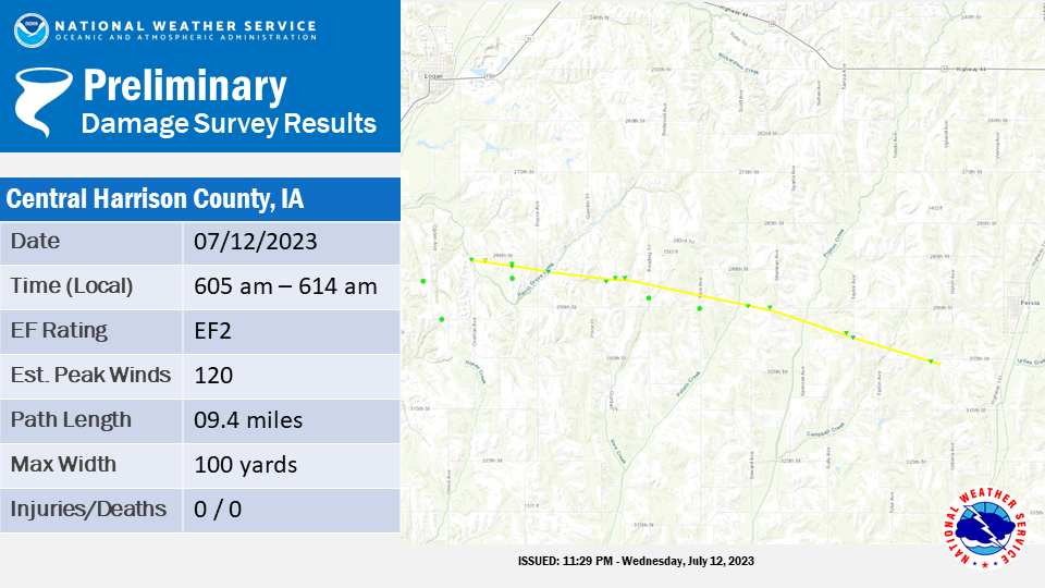
|
||||||||||||||||
|
Tornado - Portsmouth, IA
Track Map 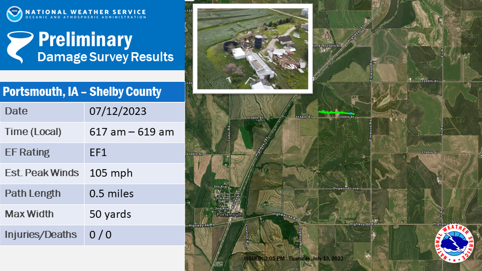
|
||||||||||||||||
|
Tornado - Avoca, IA
Track Map 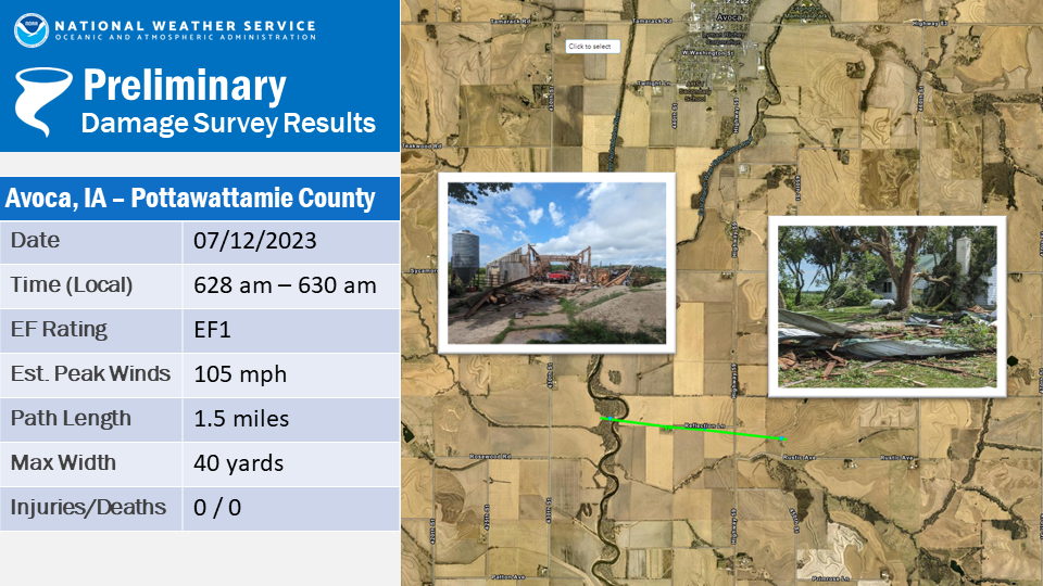
|
||||||||||||||||
|
Tornado - Walnut, IA
Track Map 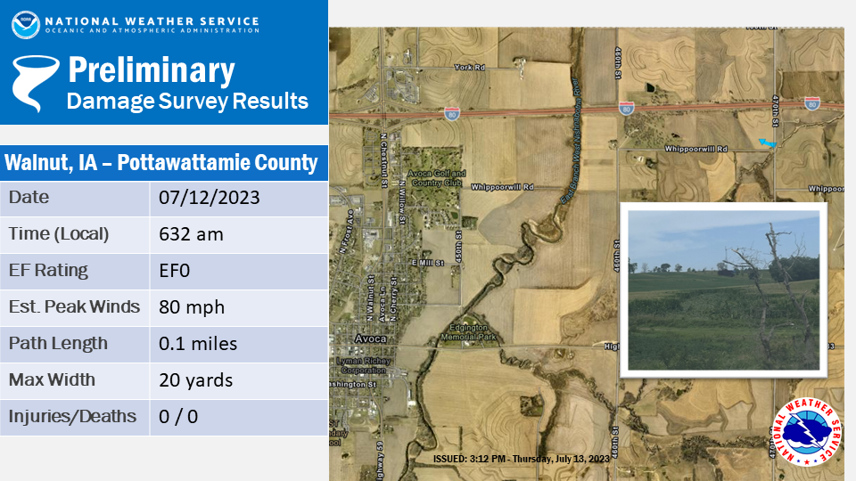
|
||||||||||||||||
The Enhanced Fujita (EF) Scale classifies tornadoes into the following categories:
| EF0 Weak 65-85 mph |
EF1 Moderate 86-110 mph |
EF2 Significant 111-135 mph |
EF3 Severe 136-165 mph |
EF4 Extreme 166-200 mph |
EF5 Catastrophic 200+ mph |
 |
|||||
Wind:
Significant wind damage was reported outside of the tornadoes, with the highest measured gust being 82 mph in Dodge County, NE, near Uehling. NWS damage surveys, however, suggest there were likely pockets of straight line winds near 100 mph.
Wind
| Damage near Bancroft, NE NWS Damage Survey |
Damage in Bancroft, NE NWS Damage Survey |
Flattened Corn near Lyons, NE NWS Damage Survey |
Damage near Lyons, NE NWS Damage Survey |
Photos
 |
 |
 |
|
| Photo taken at the NWS Valley office, as the shelf cloud moves overhead, shortly before 6 am on 7/12/2023. 70 mph winds were recorded shortly after this. | Photo taken in Papillion, NE 7/12/2023. Photo credit Keith Rose. | Map of OPPD power outages as of 7/12/2023 710 am. | Caption (source) |
Radar
 |
 |
 |
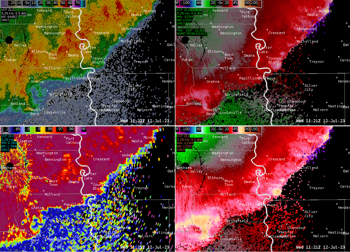 |
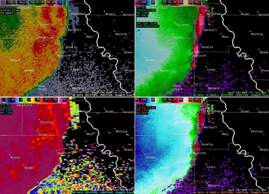
| KOAX radar 7/12/2023 at 520 am (1020 UTC). EF1 Tornado develops near Bancroft, NE. Reflectivity top left, storm relative velocity top right, correlation coefficient bottom left, base velocity bottom right. | KOAX radar 7/12/2023 at 600 am (1100 UTC). Storms as they are about to enter the Omaha metro area. Reflectivity top left, storm relative velocity top right, correlation coefficient bottom left, base velocity bottom right. | KOAX radar 7/12/2023 at 605 am (1100 UTC). Possible developing tornado south of Logan, IA. Reflectivity top left, storm relative velocity top right, correlation coefficient bottom left, base velocity bottom right. | KOAX radar 7/12/2023 at 621 am (1100 UTC). Storms moving through the Omaha and Council Bluffs metro areas. Reflectivity top left, storm relative velocity top right, correlation coefficient bottom left, base velocity bottom right. |
Storm Reports
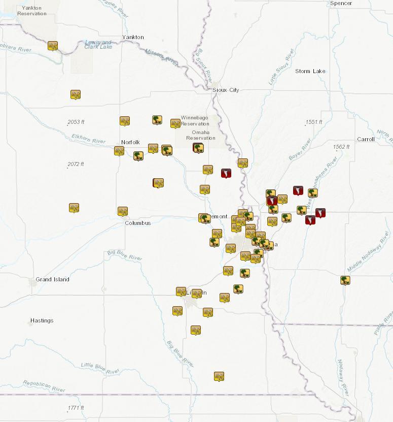
Preliminary Storm Report Map Link
Preliminary Storm Report Listing (subject to additional reports and detail)
..TIME... ...EVENT... ...CITY LOCATION... ...LAT.LON...
..DATE... ....MAG.... ..COUNTY LOCATION..ST.. ...SOURCE....
..REMARKS..
0344 AM Tstm Wnd Gst 2 ENE Verdel 42.83N 98.15W
07/12/2023 M57 MPH Knox NE Public
Measured by personal weather station.
0415 AM Tstm Wnd Gst 2 SSE Creighton 42.44N 97.90W
07/12/2023 M66 MPH Knox NE Public
Measured from personal weather station.
0445 AM Tstm Wnd Gst 8 SSW Sholes 42.23N 97.37W
07/12/2023 M63 MPH Wayne NE Public
From a personal weather station.
0451 AM Tstm Wnd Gst 3 SSW Norfolk 41.99N 97.43W
07/12/2023 M64 MPH Madison NE ASOS
Measured at KOFK ASOS.
0459 AM Tstm Wnd Dmg Wayne 42.24N 97.02W
07/12/2023 Wayne NE Public
Lots of damage to large trees throughout the
city.
0500 AM Tstm Wnd Dmg Stanton 41.95N 97.22W
07/12/2023 Stanton NE Law Enforcement
Corrects time to 5am estimated by radar.
Tstm wnd dmg report from Stanton. tree down
on house... no injuries.
0502 AM Tstm Wnd Gst Pilger 42.01N 97.06W
07/12/2023 M58 MPH Stanton NE Public
personal weather station.
0506 AM Tstm Wnd Gst 4 SW Saint Edward 41.53N 97.92W
07/12/2023 M54 MPH Boone NE Public
measured at personal weather station.
0508 AM Tstm Wnd Gst Wisner 41.99N 96.91W
07/12/2023 M66 MPH Cuming NE Public
Recorded at a personal weather station.
0508 AM Tstm Wnd Gst 1 N Wisner 42.00N 96.92W
07/12/2023 M66 MPH Cuming NE Public
personal weather station.
0510 AM Tstm Wnd Gst 7 WNW Thurston 42.21N 96.82W
07/12/2023 M64 MPH Wayne NE Public
as recorded at a personal weather station.
0510 AM Tstm Wnd Dmg Wisner 41.99N 96.91W
07/12/2023 Cuming NE Public
Large tree trunk snapped.
0514 AM Tornado Howells 41.73N 97.01W
07/12/2023 Colfax NE NWS Storm Survey
A likely tornado embedded within a broader
area of downburst winds appears to have
impacted homes and trees on the west side of
Howells, causing roof damage and shifting
the walls of a garage. Beyond this area, it
was difficult to discern any particular
tornado damage from straight line wind
damage, but there was additional damage to
trees, fences, and a power substation on the
south side of Howells as well.
0516 AM Tstm Wnd Gst Howells 41.73N 97.00W
07/12/2023 M78 MPH Colfax NE Trained Spotter
0520 AM Tstm Wnd Dmg Bancroft 42.01N 96.57W
07/12/2023 Cuming NE Trained Spotter
Updates previous tstm wnd dmg report from
Bancroft. Widespread tree damage in and near
Bancroft. Power poles snapped off. Roof
blown off of a machine shed.
0520 AM Tornado 1 NNW Bancroft 42.02N 96.58W
07/12/2023 Cuming NE NWS Storm Survey
A brief 1/2 mile long, EF1 tornado which was
imbedded with an area of intense downburst
winds, started on the north side of
Bancroft. The tornado dented in a grain bin,
destroyed an outbuilding and snapped about a
half dozen trees. The tornado continued
east, damaged some sheds, knocked over a
tractor trailer, and snapped more trees. The
duration of the tornado was 2 minutes.
0521 AM Tstm Wnd Gst 5 NNW Columbus 41.50N 97.39W
07/12/2023 M54 MPH Platte NE Public
personal weather station.
0529 AM Tstm Wnd Gst Oakland 41.84N 96.47W
07/12/2023 M62 MPH Burt NE Public
as measured by a personal weather station.
0536 AM Tstm Wnd Gst 4 S Uehling 41.68N 96.50W
07/12/2023 M82 MPH Dodge NE Public
measured by an anemometer.
0537 AM Tornado 3 NW Tekamah 41.81N 96.27W
07/12/2023 Burt NE NWS Storm Survey
Tornado debris signature was evident at this
location. A swath of corn and soybeans
approximately 30 to 50 feet wide were badly
damaged or torn out of the ground. No nearby
homes or barns were damaged.
0550 AM Tstm Wnd Gst 1 WNW Fremont 41.45N 96.52W
07/12/2023 M63 MPH Dodge NE AWOS
At Fremont Airport.
0551 AM Tstm Wnd Dmg Fremont 41.44N 96.49W
07/12/2023 Dodge NE Public
Lots of tree damage, large tree snapped at
trunk.
0559 AM Tstm Wnd Gst 1 WNW Valley 41.32N 96.37W
07/12/2023 M70 MPH Douglas NE Public
Corrects previous tstm wnd gst report from 1
WNW Valley. at NWS Omaha.
0559 AM Tstm Wnd Gst 4 NE Washington 41.43N 96.16W
07/12/2023 M60 MPH Washington NE Public
Measured on two adjacent personal weather
stations.
0559 AM Tstm Wnd Gst 5 N Bennington 41.37N 96.16W
07/12/2023 M60 MPH Douglas NE Public
personal weather station.
0600 AM Tstm Wnd Gst 3 SSW Blencoe 41.89N 96.09W
07/12/2023 M59 MPH Monona IA Public
From a personal weather station.
0600 AM Tstm Wnd Gst 4 WNW Fort Calhoun 41.48N 96.09W
07/12/2023 M58 MPH Washington NE Public
From a personal weather station.
0603 AM Tstm Wnd Dmg Logan 41.64N 95.79W
07/12/2023 Harrison IA Public
Delayed report. Roof damage to a home.
Windows blown out. Tree blown down.
0603 AM Tstm Wnd Dmg Logan 41.64N 95.79W
07/12/2023 Harrison IA Public
Roof damaged and windows blown out on house.
0605 AM Tornado 4 SSE Logan 41.59N 95.77W
07/12/2023 Harrison IA NWS Storm Survey
Correction to Time. A tornado developed near
Overton road and 286th Street in Harrison
County Iowa. The tornado moved rapidly to
the east where it made a direct impact on a
home. At this location, the home roof was
removed, windows broken, siding ruined,
numerous trees snapped, a shed was
demolished, and numerous items were thrown
up to a half mile downstream. The convergent
damage pattern at this location, eye witness
reports of wind direction, along with the 80
yard wide path of more intense damage gives
great confidence that this was a tornado.
Winds at this location were estimated at 120
mph based on damage. The tornado moved
quickly southeast, causing substantial tree
damage with snapped trunks being common
along the continued 50 to 100 yard wide
track. The tornado moved through
neighborhood of acreages along Quentin trail
where it snapped many trees but moved in
between the homes. The track then became
more intermittent for a couple miles before
it partially removed the roof of a home
along 296th Street and caused additional
narrow tree damage for the next two miles.
The final damage point that was pretty
clearly tornado damage was near 305th and
Upton where 3 grain bins were crumpled and
blown downstream and a machine shed
sustained substantial damage. Beyond this
point, the tree damage was sporadic and more
evident of the larger scale wind field.
Should also note that to the west of this
tornado track, there was a debris signature
evident on radar, but the damage was much
more consistent with a focused downburst or
series of downbursts that moved up from the
Missouri Valley into the Loess Hills and may
have helped to loft light leafy debris. This
downburst likely led to the development of
the eventual tornado.
0608 AM Tstm Wnd Gst 4 S Logan 41.58N 95.78W
07/12/2023 M58 MPH Harrison IA Public
From a personal weather station.
0609 AM Tstm Wnd Gst 6 S Fort Calhoun 41.36N 96.01W
07/12/2023 M61 MPH Douglas NE Public
personal weather station.
0610 AM Tstm Wnd Dmg 8 ESE Missouri Valley 41.52N 95.76W
07/12/2023 Harrison IA Public
Garage door blown in.
0610 AM Tstm Wnd Dmg Fort Calhoun 41.46N 96.03W
07/12/2023 Washington NE Law Enforcement
Widespread tree damage reported in town.
0611 AM Tstm Wnd Dmg Yutan 41.25N 96.40W
07/12/2023 Saunders NE Public
large tree down... time estimated from
radar.
0614 AM Tstm Wnd Gst 3 W Millard 41.20N 96.22W
07/12/2023 M59 MPH Douglas NE Public
From a personal weather station.
0615 AM Tstm Wnd Gst 4 NNE Bennington 41.42N 96.11W
07/12/2023 M60 MPH Washington NE AWOS
0616 AM Tstm Wnd Gst 5 WNW Persia 41.60N 95.66W
07/12/2023 M58 MPH Harrison IA Public
From a personal weather station.
0616 AM Tstm Wnd Gst 7 ENE Omaha 41.30N 95.90W
07/12/2023 M67 MPH Douglas NE ASOS
recorded at Eppley Airport.
0617 AM Tornado 2 NE Portsmouth 41.67N 95.49W
07/12/2023 Shelby IA NWS Storm Survey
A tornado developed just north of 1150th
street and east of Highway 191 where it
destroyed two barns and damaged others. The
tornado track continued east with evidence
of convergent flow pattern within the debris
field and the cornfield as it tracked to the
east.
0617 AM Tstm Wnd Dmg 3 ESE Council Bluffs 41.22N 95.81W
07/12/2023 Pottawattamie IA Broadcast Media
Pool roof blown off at Titan Hill
Intermediate School.
0619 AM Tstm Wnd Gst 4 N Omaha 41.32N 96.01W
07/12/2023 M74 MPH Douglas NE Public
0620 AM Tstm Wnd Dmg Neola 41.45N 95.62W
07/12/2023 Pottawattamie IA Public
Siding blown off on home.
0623 AM Tstm Wnd Dmg Shelby 41.51N 95.45W
07/12/2023 Shelby IA Public
Delayed report. Large trees blown down. Roof
damaged on home.
0623 AM Tstm Wnd Gst 2 N South Bend 41.02N 96.25W
07/12/2023 M64 MPH Sarpy NE Public
0624 AM Tstm Wnd Gst 5 WNW Underwood 41.42N 95.77W
07/12/2023 M67 MPH Pottawattamie IA Public
From a personal weather station.
0626 AM Tstm Wnd Dmg Harlan 41.65N 95.33W
07/12/2023 Shelby IA Public
Semi blown over, part of a roof blown off a
building.
0626 AM Tstm Wnd Dmg 3 N Offutt Afb 41.16N 95.92W
07/12/2023 Sarpy NE Public
large tree branches down.
0627 AM Tstm Wnd Dmg 1 SW Papillion 41.14N 96.06W
07/12/2023 Sarpy NE 911 Call Center
powerlines down and sparking.
0627 AM Tstm Wnd Gst 2 WNW Offutt Afb 41.12N 95.95W
07/12/2023 M62 MPH Sarpy NE Public
personal weather station.
0627 AM Tstm Wnd Gst 5 NW Lincoln 40.85N 96.76W
07/12/2023 M60 MPH Lancaster NE ASOS
reported by KLNK airport ASOS.
0628 AM Tornado 3 N Hancock 41.43N 95.36W
07/12/2023 Pottawattamie IA NWS Storm Survey
Correction to Time. A tornado impacted a
farm on Reflection Lane. There was
significant tree damage, windows were blown
out of the home, and a large barn had nearly
all walls collapse and the roof was removed.
There was damage to grain bins farther to
the east, and trees were topped to the west
along the Nishnabotna River.
0632 AM Tstm Wnd Gst 5 ENE Lincoln 40.83N 96.59W
07/12/2023 M59 MPH Lancaster NE Public
From a personal weather station.
0632 AM Tornado 2 WNW Walnut 41.49N 95.25W
07/12/2023 Pottawattamie IA NWS Storm Survey
Correction to Time. There is a distinct
tornado track through a cornfield
approximately 20 yards wide. The track
begins in the corn field and seems to end
near the road where a couple of branches are
snapped.
0632 AM Tstm Wnd Dmg 4 E Omaha 41.26N 95.94W
07/12/2023 Douglas NE Public
Medium tree snapped at trunk.
0633 AM Tstm Wnd Dmg Weeping Water 40.87N 96.14W
07/12/2023 Cass NE Public
Carport destroyed.
0634 AM Tstm Wnd Gst 2 SSW Papillion 41.14N 96.06W
07/12/2023 M62 MPH Sarpy NE Public
From a personal weather station.
0634 AM Tstm Wnd Gst 3 S Elmwood 40.80N 96.29W
07/12/2023 M62 MPH Cass NE Public
personal weather station.
0638 AM Tstm Wnd Dmg Council Bluffs 41.24N 95.86W
07/12/2023 Pottawattamie IA Public
Several reports of tree damage.
0639 AM Tstm Wnd Dmg 3 SSE Cedar Creek 41.00N 96.07W
07/12/2023 Cass NE Law Enforcement
trees down across hwy 66.
0640 AM Tstm Wnd Gst 4 NW Martell 40.69N 96.80W
07/12/2023 M65 MPH Lancaster NE Public
personal weather station.
0641 AM Tstm Wnd Gst 2 E Bennet 40.68N 96.47W
07/12/2023 M61 MPH Lancaster NE Public
Measured with two adjacent personal weather
stations.
0653 AM Tstm Wnd Gst Firth 40.53N 96.60W
07/12/2023 M63 MPH Lancaster NE Trained Spotter
0715 AM Tstm Wnd Gst Burchard 40.15N 96.35W
07/12/2023 M58 MPH Pawnee NE Public
Corrects previous tstm wnd gst report from
Burchard.
0715 AM Tstm Wnd Dmg 1 NNW Villisca 40.94N 94.98W
07/12/2023 Montgomery IA Public
Trees blown down at the golf course.
&&
Environment
|
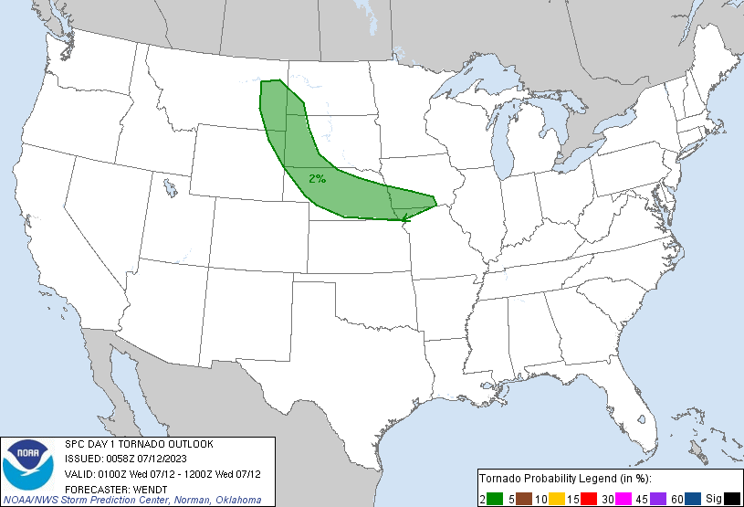
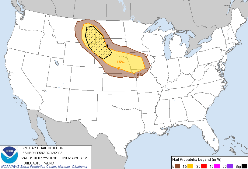
Convective Outlook issued at 7/11/2023 at 8 pm
|
||
 |
 |
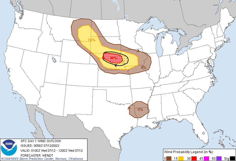 |
| Tornado Outlook issued at 7/11/2023 at 8 pm | Wind Outlook issued at 7/11/2023 at 8 pm | Wind Outlook issued at 7/11/2023 at 8 pm |
 |
 |
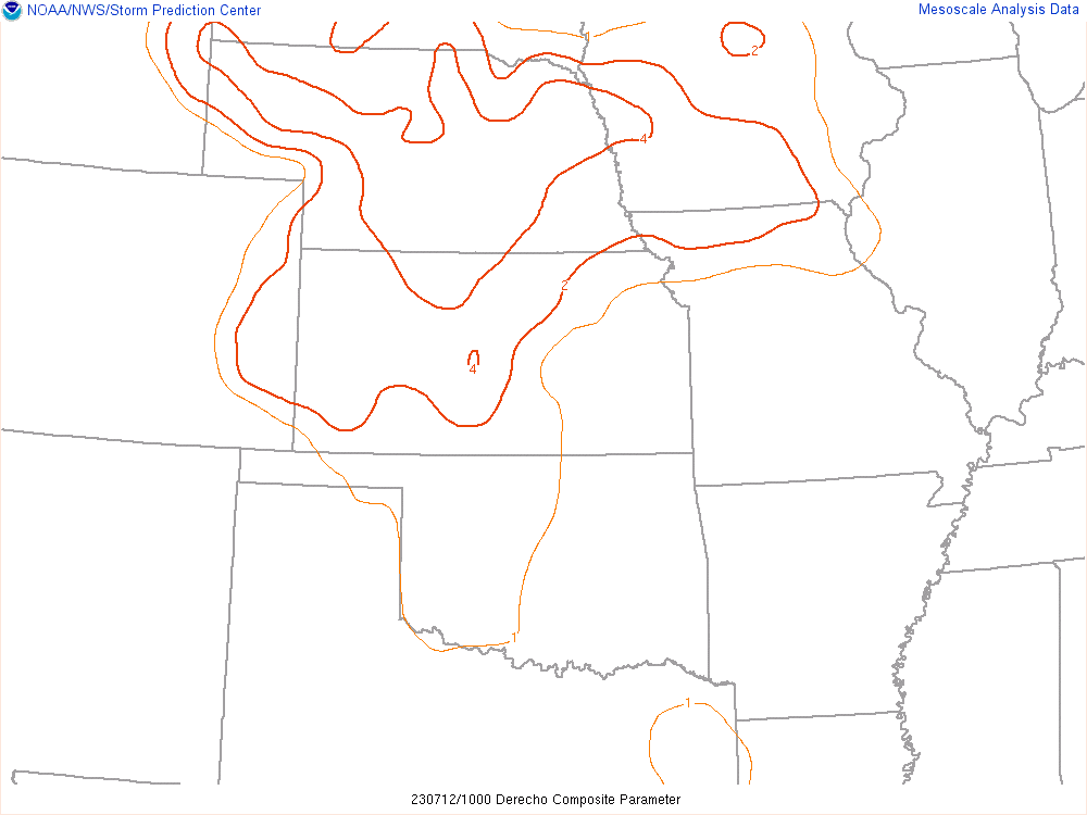 |
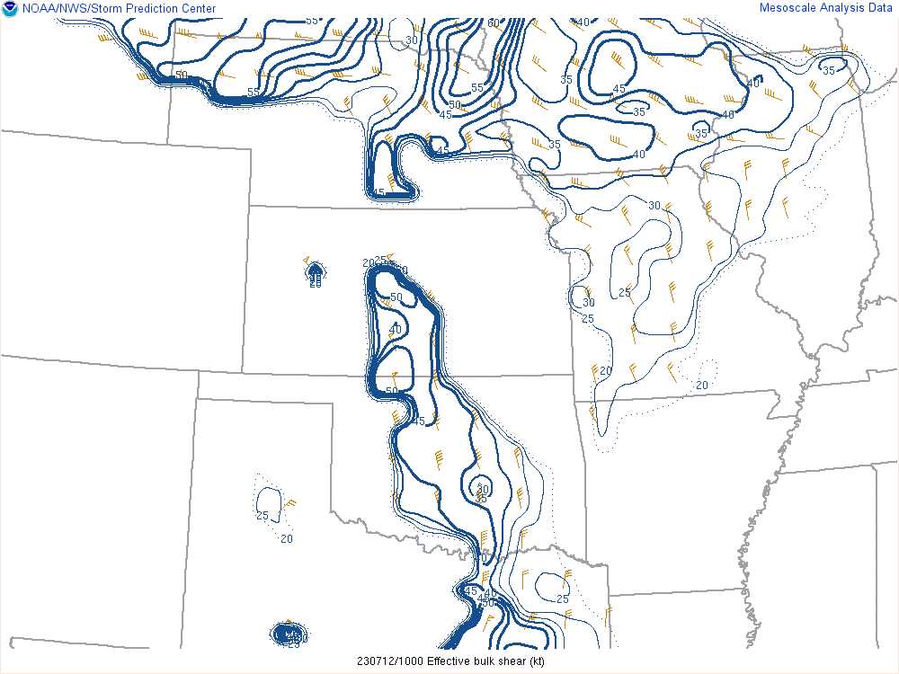
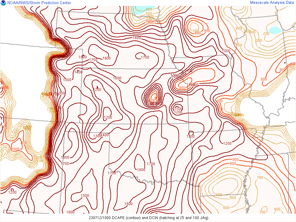
| Effective shear 7/12/2023 at 5 am | Downdraft Cape 7/12/2023 at 5 am | Derecho Composite 7/12/2023 at 5 am |
 |
Media use of NWS Web News Stories is encouraged! Please acknowledge the NWS as the source of any news information accessed from this site. |
|