
Extreme heat continues today from the central Plains to the lower Mississippi River Valley, over southeast Montana, and from southern California into the Southwest Deserts. Extreme Heat Warnings remain in effect. Severe thunderstorms capable of strong to severe wind gusts and large hail are possible across the Great Lakes into the Ohio Valley today into tonight. Read More >
Overview
|
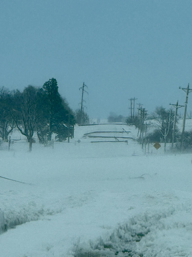
An intense low pressure system moved across the Central Plains and into the Great Lakes on March 19th, bringing strong to severe thunderstorms, widespread heavy snow, and strong to damaging winds to much of the Midwest. The NWS Omaha coverage area experienced all of these hazards, with thunderstorms developing during the early morning hours, including one that produced quarter sized hail near Fort Calhoun, NE. The rain switched over to sleet through the morning and eventually heavy, wet snow, with thundersnow occurring for a few hours. In addition, 50-70+ mph wind gusts were observed with the falling snow, leading to near 0 visibility and widespread damage to trees and power lines, with numerous power outages across eastern Nebraska and southwest Iowa. Many roads and highways were also closed throughout the event. |
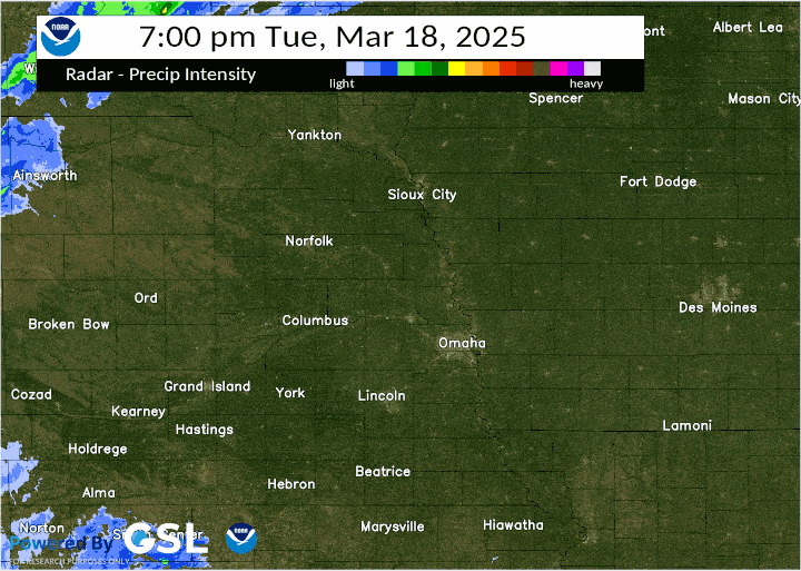 Radar Loop. Click to enlarge. |
Snow/Ice
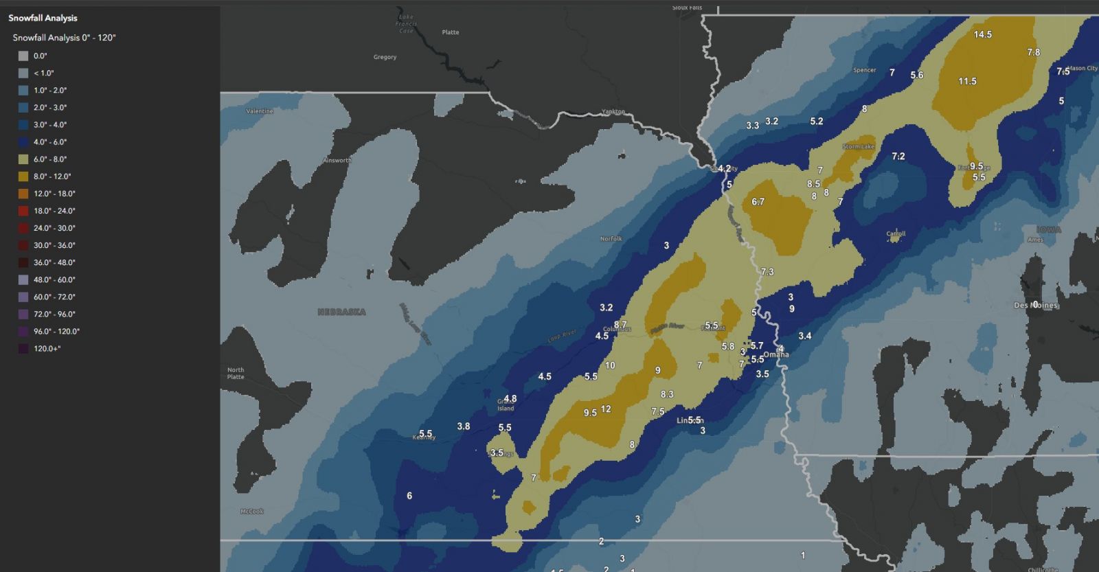 |
| Snow Accumulations |
Snowfall Reports (note: some of these were from the middle of the event and may not reflect final totals)
Location                     Amount    Time/Date       Lat/Lon

...Iowa...

...Fremont County...
3 WSW Sidney                  T in     0700 AM 03/20   40.72N/95.70W

...Harrison County...
5 S Logan                    9.0 in    0400 PM 03/19   41.57N/95.79W
2 NW Little Sioux            7.3 in    0700 AM 03/20   41.82N/96.02W
Logan 0.8 WNW                3.0 in    0700 AM 03/20   41.65N/95.81W

...Mills County...
Glenwood 1.7 WSW             0.8 in    0900 AM 03/20   41.04N/95.77W

...Pottawattamie County...
Underwood                    3.4 in    0700 AM 03/20   41.39N/95.68W
Council Bluffs               2.5 in    0139 PM 03/19   41.24N/95.86W
Oakland                      1.5 in    0700 AM 03/20   41.31N/95.39W
Council Bluffs 2.1 SSE       1.5 in    0800 AM 03/20   41.21N/95.85W

...Shelby County...
Earling 2.4 SE                T in     0700 AM 03/20   41.75N/95.39W

...Nebraska...

...Antelope County...
0.9 E Oakdale                0.5 in    0800 AM 03/20   42.07N/97.95W
Elgin                        0.5 in    0830 AM 03/20   41.97N/98.08W

...Boone County...
9.6 N Primrose               2.1 in    0700 AM 03/20   41.76N/98.21W

...Butler County...
Brainard 1.8 SSE             9.0 in    0700 AM 03/20   41.16N/97.00W

...Cuming County...
Wisner 0.4 NNW               3.0 in    0700 AM 03/20   41.99N/96.92W
Wisner                       2.5 in    0807 AM 03/19   41.99N/96.91W

...Dodge County...
2 NW Fremont                 5.5 in    1200 PM 03/19   41.46N/96.52W
1 N Fremont                  5.0 in    0427 PM 03/19   41.45N/96.50W
1 NNW Fremont                5.0 in    0427 PM 03/19   41.45N/96.50W
Hooper 0.2 NNE                T in     0630 AM 03/20   41.62N/96.55W

...Douglas County...
3 SSE Bennington             8.4 in    0700 AM 03/20   41.32N/96.14W
3 SE Boys Town               8.1 in    0400 PM 03/19   41.23N/96.10W
Elkhorn 0.8 NNW              7.9 in    0700 AM 03/20   41.29N/96.24W
2.9 SSW Bennington           7.9 in    0700 AM 03/20   41.33N/96.17W
Elkhorn 0.7 ENE              7.6 in    0700 AM 03/20   41.29N/96.22W
3 WSW Boys Town              7.0 in    0433 PM 03/19   41.25N/96.19W
3 WSW Boys Town              7.0 in    0433 PM 03/19   41.25N/96.19W
4 N Gretna                   7.0 in    0500 PM 03/19   41.19N/96.24W
Chalco 4.8 WNW               7.0 in    0800 AM 03/20   41.22N/96.21W
4 N Gretna                   7.0 in    0800 AM 03/20   41.20N/96.25W
4 N Gretna                   6.8 in    0100 PM 03/19   41.20N/96.25W
1 W Millard                  6.5 in    1250 PM 03/19   41.21N/96.18W
5 NNE Omaha                  6.0 in    0128 PM 03/19   41.33N/95.96W
Omaha 13.2 WSW               6.0 in    0700 AM 03/20   41.21N/96.18W
NWS Office - Valley          5.8 in    0500 PM 03/19   41.32N/96.37W
Omaha 2.0 N                  5.8 in    0700 AM 03/20   41.29N/96.01W
4 SE Bennington              5.7 in    0600 PM 03/19   41.32N/96.11W
2 SE Boys Town               5.5 in    1159 AM 03/19   41.23N/96.10W
5 N Omaha                    5.5 in    0118 PM 03/19   41.34N/95.99W
3 NNW Boys Town              5.2 in    0130 PM 03/19   41.30N/96.15W
3 WNW Boys Town              5.0 in    0142 PM 03/19   41.28N/96.18W
4 SE Bennington              4.7 in    1200 PM 03/19   41.32N/96.11W
4 N Gretna                   4.5 in    1017 AM 03/19   41.20N/96.25W
Eppley Airfield              4.0 in    0700 PM 03/19   41.30N/95.89W
Elkhorn                      3.0 in    1224 PM 03/19   41.28N/96.24W
3 NNW Boys Town              2.7 in    1026 AM 03/19   41.30N/96.15W
2 ESE Omaha                  2.7 in    0146 PM 03/19   41.26N/95.97W
3 WNW Ralston                2.5 in    0900 AM 03/19   41.22N/96.09W
2 WNW Millard                2.5 in    0959 AM 03/19   41.22N/96.18W
4 NW Omaha                   2.5 in    0208 PM 03/19   41.31N/96.07W
4 N Gretna                   2.2 in    0913 AM 03/19   41.20N/96.25W

...Gage County...
DeWitt 1.4 SE                2.0 in    0700 AM 03/20   40.38N/96.91W
2.1 N Beatrice               1.0 in    0700 AM 03/20   40.30N/96.75W

...Jefferson County...
Fairbury                     3.0 in    0509 PM 03/19   40.14N/97.18W
Fairbury 0.39 N              3.0 in    0700 AM 03/20   40.15N/97.18W
Fairbury 0.6 N               3.0 in    0700 AM 03/20   40.15N/97.18W
Fairbury 11.4 NW             2.0 in    0700 AM 03/20   40.27N/97.32W

...Knox County...
Verdel 6 SSE                  T in     0700 AM 03/20   42.72N/98.22W

...Lancaster County...
Raymond 7.3 WNW              8.3 in    0800 AM 03/20   41.00N/96.91W
Lincoln 1.2 ENE              5.5 in    0700 AM 03/20   40.82N/96.67W
3 N Lincoln                  5.0 in    1131 AM 03/19   40.85N/96.70W
Lincoln Airport              5.0 in    0700 PM 03/19   40.85N/96.76W
Lincoln 6.8 SE               3.0 in    0700 AM 03/20   40.75N/96.59W
Lincoln 4.5 SE               2.0 in    0700 AM 03/20   40.77N/96.63W
Lincoln 7.1 SE               2.0 in    0800 AM 03/20   40.73N/96.61W
Lincoln 2.7 SSW              1.9 in    0700 AM 03/20   40.78N/96.71W
Waverly 0.4 W                1.6 in    0845 AM 03/20   40.92N/96.54W
Lincoln 8.1 SSE              1.5 in    0800 AM 03/20   40.71N/96.62W
Lincoln 5.8 WSW              0.5 in    0700 AM 03/20   40.75N/96.76W
Lincoln 6.1 SSE              0.2 in    1000 AM 03/19   40.74N/96.64W

...Madison County...
Norfolk Airport              0.7 in    0700 PM 03/19   41.99N/97.44W

...Otoe County...
1.7 N Nebraska City          1.0 in    0700 AM 03/20   40.70N/95.87W

...Pawnee County...
4 SE Lewiston                1.2 in    0420 PM 03/19   40.21N/96.35W
4.0 N Table Rock              T in     0700 AM 03/20   40.24N/96.09W

...Platte County...
2.5 NE Columbus              8.7 in    1200 AM 03/20   41.46N/97.33W
Duncan                       4.5 in    1228 PM 03/19   41.39N/97.49W
Columbus                     4.0 in    0906 AM 03/19   41.43N/97.36W
3 NE Platte Center           3.2 in    0130 PM 03/19   41.58N/97.46W
Columbus                     2.5 in    0803 AM 03/19   41.43N/97.36W

...Richardson County...
Dawson 2.5 SE                0.5 in    0700 AM 03/20   40.10N/95.81W
Verdon 3.9 N                 0.5 in    0700 AM 03/20   40.20N/95.71W
2 SW Shubert                 0.5 in    0700 AM 03/20   40.20N/95.71W
Falls City 5.5 NE            0.3 in    0700 AM 03/20   40.12N/95.53W
Verdon 9.5 SSW               0.2 in    0700 AM 03/20   40.02N/95.79W
Salem 5 SW                   0.2 in    0700 AM 03/20   40.02N/95.79W

...Saline County...
Friend                       8.0 in    0700 AM 03/20   40.65N/97.28W
Friend 3.4 E                 8.0 in    0700 AM 03/20   40.66N/97.22W

...Sarpy County...
3 N Gretna                   7.0 in    0500 PM 03/19   41.19N/96.24W
Gretna 3.0 NNE               7.0 in    0700 AM 03/20   41.18N/96.22W
3 N Gretna                   5.7 in    1100 AM 03/19   41.19N/96.25W
3 SW Millard                 5.0 in    1222 PM 03/19   41.17N/96.19W
3 SW Millard                 5.0 in    1222 PM 03/19   41.17N/96.19W
Gretna 2.9 NNE               5.0 in    0800 AM 03/20   41.18N/96.22W
La Vista 2.0 WSW             4.1 in    0700 AM 03/20   41.18N/96.08W
Papillion 1.9 SSW            3.5 in    0700 AM 03/20   41.13N/96.06W
Gretna 0.9 ENE               3.0 in    1000 AM 03/19   41.14N/96.23W
La Vista                     3.0 in    1145 AM 03/19   41.18N/96.04W
Bellevue 3.3 WSW             2.0 in    0700 AM 03/20   41.11N/95.94W
Papillion 0.8 WSW            2.0 in    0700 AM 03/20   41.15N/96.06W
Papillion 1.2 WSW            1.5 in    0700 AM 03/20   41.14N/96.06W

...Saunders County...
1 S Leshara                  7.1 in    0354 PM 03/19   41.32N/96.43W
Wahoo 1.7 S                  7.0 in    0700 AM 03/20   41.19N/96.62W

...Seward County...
Seward 0.5 NE                7.7 in    0700 AM 03/20   40.92N/97.09W
Garland 4.56 S               7.5 in    0700 AM 03/20   40.88N/96.99W
Seward                       2.5 in    0758 AM 03/19   40.91N/97.10W

...Washington County...
Blair 0.9 NNW                6.5 in    0800 AM 03/20   41.56N/96.15W
Blair                        5.0 in    1152 AM 03/19   41.54N/96.14W

Observations are collected from a variety of sources with varying
equipment and exposures. We thank all volunteer weather observers
for their dedication. Not all data listed are considered official.
Wind
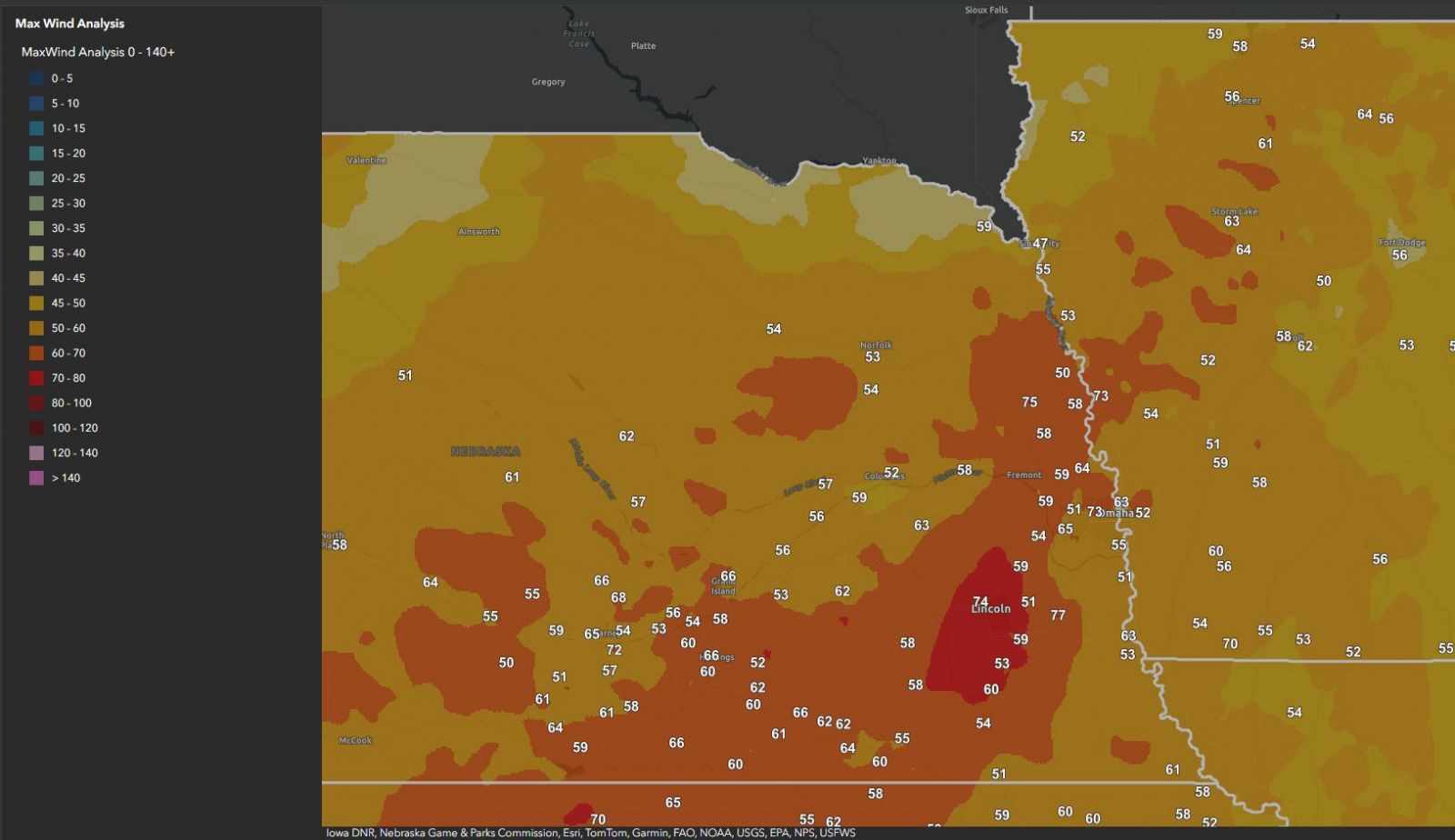 |
| Wind Reports |
Measured Wind Gusts
Location                     Speed     Time/Date       Lat/Lon

...Iowa...

...Fremont County...
Shenandoah Airport           54 MPH    0355 PM 03/19   40.75N/95.42W

...Harrison County...
Rlsi4                        73 MPH    0650 AM 03/19   41.80N/96.03W
1.3 SW Woodbine (UPR)        54 MPH    0144 PM 03/19   41.72N/95.72W
Mondamin                     41 MPH    1235 PM 03/19   41.71N/96.01W
Missouri Valley              40 MPH    0510 AM 03/19   41.55N/95.92W

...Monona County...
Sloan                        53 MPH    0725 AM 03/19   42.17N/96.23W

...Montgomery County...
7 NE Emerson                 60 MPH    0224 PM 03/19   41.09N/95.32W
Red Oak Airport              56 MPH    0555 PM 03/19   41.02N/95.27W
6 NE Emerson                 46 MPH    0400 PM 03/19   41.09N/95.31W

...Page County...
Coin                         70 MPH    0145 PM 03/19   40.66N/95.23W
Clarinda Airport             55 MPH    0355 PM 03/19   40.72N/95.02W
Essex                        42 MPH    1025 AM 03/19   40.82N/95.25W

...Pottawattamie County...
Avoca                        59 MPH    0610 AM 03/19   41.50N/95.29W
Council Bluffs Airport       52 MPH    0535 AM 03/19   41.27N/95.77W
Council Bluffs Dms           45 MPH    0525 AM 03/19   41.26N/95.80W
Carter Lake                  44 MPH    0150 PM 03/19   41.29N/95.92W
UNDERWOOD                    44 MPH    0250 PM 03/19   41.42N/95.77W
Hancock                      44 MPH    0250 PM 03/19   41.41N/95.44W
Loess Hills Hitchcock        41 MPH    0211 PM 03/19   41.42N/95.85W

...Shelby County...
Harlan Airport               51 MPH    0555 AM 03/19   41.58N/95.33W
Westphalia                   44 MPH    0705 AM 03/19   41.70N/95.38W

...Nebraska...

...Antelope County...
Neligh                       54 MPH    1035 AM 03/19   42.11N/98.04W
Ewing 5ESE                   42 MPH    1000 AM 03/19   42.24N/98.24W
Ewing 5ESE                   42 MPH    1000 AM 03/19   42.24N/98.24W
Creighton                    42 MPH    0525 PM 03/19   42.44N/97.89W
2 W Elgin                    41 MPH    0910 AM 03/19   41.99N/98.13W

...Boone County...
Albion Airport               45 MPH    1255 AM 03/19   41.73N/98.05W
Newman Grove                 40 MPH    0325 PM 03/19   41.84N/97.86W

...Burt County...
4 NE Uehling                 75 MPH    0936 AM 03/19   41.77N/96.46W
Tekamah Airport              58 MPH    0724 AM 03/19   41.77N/96.18W
Decatur 7S                   50 MPH    0755 AM 03/19   41.91N/96.26W
Oakland 4W                   48 MPH    0525 AM 03/19   41.84N/96.54W

...Butler County...
David City                   63 MPH    0108 AM 03/19   41.21N/97.13W

...Cass County...
4 S Elmwood                  77 MPH    1245 PM 03/19   40.79N/96.29W
Plattsmouth                  51 MPH    0141 PM 03/19   40.97N/95.88W
Plattsmouth Airport          49 MPH    0155 PM 03/19   40.95N/95.92W
Weeping Water                43 MPH    0415 AM 03/19   40.87N/96.11W
Plattsmouth                  42 MPH    0135 PM 03/19   41.05N/96.01W

...Cedar County...
Fordyce 4N                   40 MPH    0640 AM 03/19   42.75N/97.35W
Hartington                   40 MPH    0715 AM 03/19   42.60N/97.43W
Randolph                     40 MPH    0300 PM 03/19   42.47N/97.46W

...Colfax County...
2.5 W Schuyler (UPR)         44 MPH    0509 AM 03/19   41.45N/97.11W

...Dodge County...
2.4 E Rogers (UPR)           58 MPH    1154 AM 03/19   41.46N/96.87W
2 E Rogers                   58 MPH    1154 AM 03/19   41.46N/96.87W
Fremont Airport              45 MPH    0535 AM 03/19   41.45N/96.52W
3.7 N Cedar Bluffs (UPR)     43 MPH    0857 AM 03/19   41.45N/96.60W

...Douglas County...
3 W Omaha                    73 MPH    1135 AM 03/19   41.27N/96.06W
4 N Gretna                   65 MPH    1115 AM 03/19   41.19N/96.25W
Omaha Eppley Airfield        63 MPH    0144 PM 03/19   41.32N/95.90W
1 WNW Valley                 59 MPH    1000 AM 03/19   41.32N/96.37W
3 S Bennington               58 MPH    1118 AM 03/19   41.32N/96.16W
3 W Millard                  52 MPH    0114 AM 03/19   41.21N/96.21W
2 E Elkhorn                  51 MPH    1259 AM 03/19   41.28N/96.19W
2.3 NE Leshara (UPR)         51 MPH    1101 AM 03/19   41.36N/96.41W
OMAHA                        43 MPH    1254 PM 03/19   41.25N/96.03W
Millard Airport              43 MPH    0115 PM 03/19   41.20N/96.12W

...Gage County...
4 S Cortland                 60 MPH    0224 PM 03/19   40.44N/96.70W
Beatrice Municip             54 MPH    0115 PM 03/19   40.28N/96.75W
Wymore                       51 MPH    0302 PM 03/19   40.04N/96.65W
S.cortland On Hwy 77 @ Mp 37 42 MPH    0141 PM 03/19   40.47N/96.72W

...Jefferson County...
7 WNW Fairbury               59 MPH    0915 AM 03/19   40.16N/97.30W
6 NW Fairbury (Hedriw)       55 MPH    0112 PM 03/19   40.21N/97.25W
Steele City (UPR)            42 MPH    0254 AM 03/19   40.04N/97.03W
Daykin                       42 MPH    0925 AM 03/19   40.32N/97.30W

...Johnson County...
Cook 4SW                     43 MPH    0235 PM 03/19   40.47N/96.21W

...Lancaster County...
Lincoln Airport              74 MPH    1108 AM 03/19   40.85N/96.77W
6 NW Greenwood               59 MPH    1245 AM 03/19   41.02N/96.52W
1 WSW Bennet                 59 MPH    0910 AM 03/19   40.68N/96.52W
4 WNW Bennet                 58 MPH    1210 AM 03/19   40.70N/96.57W
Firth                        53 MPH    0245 PM 03/19   40.56N/96.63W
Eagle 3NW Beta               51 MPH    1255 PM 03/19   40.85N/96.47W
Firth 3N                     45 MPH    0245 PM 03/19   40.57N/96.61W
Hallam                       41 MPH    0215 PM 03/19   40.54N/96.78W
Lincoln                      40 MPH    1250 PM 03/19   40.73N/96.67W

...Madison County...
Hwy 81 At Madison Union Cree 54 MPH    0328 AM 03/19   41.83N/97.44W
Norfolk Airport              53 MPH    0605 AM 03/19   41.98N/97.43W
NORFOLK                      42 MPH    0315 PM 03/19   42.05N/97.43W

...Otoe County...
1 N Nebraska City            63 MPH    0203 PM 03/19   40.69N/95.86W
Nebraska City Airport        53 MPH    0335 PM 03/19   40.61N/95.86W
NEBRASKA CITY 3W             46 MPH    0410 PM 03/19   40.69N/95.91W

...Platte County...
Columbus Airport             52 MPH    0607 AM 03/19   41.45N/97.32W
Columbus                     44 MPH    0505 AM 03/19   41.51N/97.29W
Columbus                     43 MPH    1257 AM 03/19   41.45N/97.39W
Leigh 1W                     43 MPH    0510 AM 03/19   41.71N/97.26W
3.8 W Columbus (UPR)         43 MPH    1031 AM 03/19   41.42N/97.43W
Columbus                     41 MPH    1245 AM 03/19   41.45N/97.35W

...Richardson County...
Falls City Airport           61 MPH    0217 PM 03/19   40.07N/95.58W
Rulo 5SW                     48 MPH    0145 PM 03/19   40.02N/95.50W

...Saline County...
5 NNE Western                58 MPH    0943 AM 03/19   40.47N/97.17W
Friend                       58 MPH    1239 PM 03/19   40.66N/97.22W
Wilber 1W                    48 MPH    0125 PM 03/19   40.47N/96.99W
Friend                       46 MPH    0700 AM 03/19   40.65N/97.28W

...Sarpy County...
3 E Gretna                   67 MPH    1243 AM 03/19   41.14N/96.18W
2 ENE Gretna                 64 MPH    1105 AM 03/19   41.15N/96.21W
Bellevue                     55 MPH    0147 PM 03/19   41.12N/95.99W
Offutt Afb                   55 MPH    0256 PM 03/19   41.12N/95.92W
Springfield                  49 MPH    1150 AM 03/19   41.08N/96.13W
Gretna                       40 MPH    0425 AM 03/19   41.05N/96.24W

...Saunders County...
Memphis 5N                   54 MPH    1200 PM 03/19   41.16N/96.41W
Memphis 4N                   53 MPH    1035 AM 03/19   41.15N/96.44W
Wahoo                        49 MPH    0615 AM 03/19   41.23N/96.60W
Valparaiso 6NW               40 MPH    1120 AM 03/19   41.16N/96.87W

...Seward County...
Milford                      42 MPH    0545 AM 03/19   40.83N/97.06W
Milford                      41 MPH    0445 AM 03/19   40.77N/97.05W

...Stanton County...
Pender                       41 MPH    0615 AM 03/19   42.03N/97.02W

...Washington County...
3 E Kennard                  64 MPH    1035 AM 03/19   41.47N/96.14W
4.1 SW Kennard (UPR)         59 MPH    1037 AM 03/19   41.44N/96.27W
Winslow 6E                   58 MPH    1030 AM 03/19   41.63N/96.38W
Blair Muni                   47 MPH    0515 AM 03/19   41.42N/96.12W

...Wayne County...
Wayne Muni                   46 MPH    0435 AM 03/19   42.25N/96.98W

Observations are collected from a variety of sources with varying
equipment and exposures. We thank all volunteer weather observers
for their dedication. Not all data listed are considered official.
Storm Reports
..TIME...   ...EVENT...      ...CITY LOCATION...     ...LAT.LON...
..DATE...   ....MAG....      ..COUNTY LOCATION..ST.. ...SOURCE....
            ..REMARKS..

1015 AM     Blizzard         3 SSW Onawa             41.98N 96.10W
03/19/2025                   Monona             IA   Dept of Highways

            Interstate 29 closed from Missouri Valley to
            South Dakota border due to blizzard
            conditions and powerlines across the road at
            mile marker 110.

1030 AM     Blizzard         West Point              41.84N 96.71W
03/19/2025                   Cuming             NE   Dept of Highways

            Highway 51, 9, and 32 closed in much of
            Cuming County due to blizzard conditions.

1030 AM     Blizzard         Seward                  40.91N 97.10W
03/19/2025                   Seward             NE   Dept of Highways

            Interstate 80, Highway 15, 34, and others in
            Seward County all closed due to blizzard
            conditions.

1030 AM     Blizzard         3 NNW Macy              42.15N 96.39W
03/19/2025                   Thurston           NE   Dept of Highways

            US Highway 75, highway 9, and highway 94
            closed across Thurston County due to
            blizzard conditions.

1030 AM     Blizzard         1 N Schuyler            41.47N 97.06W
03/19/2025                   Colfax             NE   Dept of Highways

            US Highway 30 across Colfax County closed
            due to blizzard conditions.

1030 AM     Blizzard         1 NW Dorchester         40.66N 97.13W
03/19/2025                   Saline             NE   Dept of Highways

            US Highway 6, and highway 15 in Saline
            County closed due to blizzard conditions.

1030 AM     Blizzard         5 N Denton              40.81N 96.84W
03/19/2025                   Lancaster          NE   Dept of Highways

            Interstate 80, portions of US highway 6,
            highway 34 west of Lincoln closed due to
            blizzard conditions.

1030 AM     Blizzard         Tekamah                 41.78N 96.22W
03/19/2025                   Burt               NE   Dept of Highways

            US Highway 75 and highway 32 closed in Burt
            county due to blizzard conditions.

1045 AM     Blizzard         8 S Pilger              41.90N 97.06W
03/19/2025                   Stanton            NE   Dept of Highways

            Highway 32 closed in eastern Stanton County
            due to blizzard conditions.

1045 AM     Blizzard         3 WNW Leigh             41.71N 97.30W
03/19/2025                   Platte             NE   Dept of Highways

            Highway 91 closed across Platte and Colfax
            Counties due to blizzard conditions.

1110 AM     Blizzard         1 ENE Bennington        41.37N 96.15W
03/19/2025                   Douglas            NE   Dept of Highways

            Fallen trees on Highway 36 east of
            Bennington between N 153rd Circle and N
            144th Plaza. Highway 36 closed.

1115 AM     Blizzard         Blair                   41.54N 96.14W
03/19/2025                   Washington         NE   Dept of Highways

            US Highway 30 and highway 91 closed across
            Washington County due to blizzard.

1115 AM     Blizzard         1 WNW Mead              41.23N 96.50W
03/19/2025                   Saunders           NE   Dept of Highways

            US Highway 77 and highway 92 closed in parts
            of Saunders County due to blizzard.

1140 AM     Blizzard         4 E Bennington          41.36N 96.08W
03/19/2025                   Douglas            NE   Dept of Highways

            Highway 36 in Douglas County closed due to
            blizzard conditions.

1157 AM     Blizzard         2 WSW Yutan             41.23N 96.43W
03/19/2025                   Saunders           NE   Dept of Highways

            Power lines down along County Road
            M/Nebraska 92 between Mead and Yutan.

0130 PM     Blizzard         1 NW Martell            40.65N 96.77W
03/19/2025                   Lancaster          NE   Dept of Highways

            Several highways, including 2, 43, 33, 6,
            34, and I-80 closed in parts of Lancaster
            County.

0140 PM     Blizzard         8 N Western             40.51N 97.18W
03/19/2025                   Saline             NE   Dept of Highways

            Several highways, including 15, 74,41, and
            others closed in Saline County due to
            blizzard.

0140 PM     Blizzard         Fairbury                40.15N 97.18W
03/19/2025                   Jefferson          NE   Dept of Highways

            Several highways, including US 136, highways
            15, 4, and 8 are closed across Jefferson
            County due to blizzard.

0140 PM     Blizzard         Waterloo                41.29N 96.29W
03/19/2025                   Douglas            NE   Dept of Highways

            Partial closures of highways 275, 6, 64, and
            36 in northern and western Douglas County
            due to blizzard.

0140 PM     Blizzard         1 SSW Winslow           41.59N 96.51W
03/19/2025                   Dodge              NE   Dept of Highways

            US Highways 30, 275, and 75, and highways 91
            and 79 closed in Dodge County due to
            blizzard.

0200 PM     Blizzard         4 WNW Earling           41.80N 95.48W
03/19/2025                   Shelby             IA   Dept of Highways

            Highway 37 is closed due to blizzard
            conditions.

0200 PM     Blizzard         3 S Cortland            40.47N 96.70W
03/19/2025                   Gage               NE   Dept of Highways

            Highway 41 and 4 are closed due to blizzard
            conditions across northern and western Gage
            County.

0200 PM     Blizzard         2 W Portsmouth          41.65N 95.56W
03/19/2025                   Harrison           IA   Dept of Highways

            Highway 44 closed across much of Shelby and
            Harrison counties due to blizzard
            conditions.

0753 AM     Non-Tstm Wnd Dmg Fremont                 41.44N 96.49W
03/19/2025                   Dodge              NE   Public

            Report via social media of many tree limbs
            down and no power.

0901 AM     Non-Tstm Wnd Dmg Tekamah                 41.78N 96.22W
03/19/2025                   Burt               NE   Emergency Mngr

            Burt County EM reported large tree branches
            down.

0956 AM     Non-Tstm Wnd Dmg Fremont                 41.44N 96.49W
03/19/2025                   Dodge              NE   Emergency Mngr

            EM reports several downed powerlines and
            trees across Dodge County.

1000 AM     Non-Tstm Wnd Dmg 3 NNE Leshara           41.38N 96.41W
03/19/2025                   Douglas            NE   Dept of Highways

            Highway 36 closed due to downed powerlines
            on the road.

1038 AM     Non-Tstm Wnd Dmg Scribner                41.66N 96.66W
03/19/2025                   Dodge              NE   Public

            Picture and report on social media of
            snapped power poles in Scribner.

1104 AM     Non-Tstm Wnd Dmg Seward                  40.91N 97.10W
03/19/2025                   Seward             NE   Broadcast Media

            Social media post showing large tree limbs
            down, including one on top of a truck.

1110 AM     Non-Tstm Wnd Dmg 2 WNW Millard           41.22N 96.18W
03/19/2025                   Douglas            NE   NWS Employee

            2 inch diameter tree limb reported down by
            NWS employee.

1145 AM     Non-Tstm Wnd Dmg 3 WSW Wahoo             41.21N 96.68W
03/19/2025                   Saunders           NE   Public

            Public report of seven power poles knocked
            down in between Wahoo and Weston.

1239 PM     Non-Tstm Wnd Dmg 2 NW Lincoln            40.84N 96.72W
03/19/2025                   Lancaster          NE   Public

            Large cedar tree snapped near 1st and Adams.

0147 PM     Non-Tstm Wnd Dmg 4 E Yutan               41.23N 96.33W
03/19/2025                   Douglas            NE   Dept of Highways

            Downed power lines along Highway 92 1 mile
            east of Venice.

0149 PM     Non-Tstm Wnd Dmg 1 WSW La Vista          41.18N 96.06W
03/19/2025                   Sarpy              NE   Broadcast Media

            Relayed by KMTV, report of snapped power
            poles at 96th and Giles.

0200 PM     Non-Tstm Wnd Dmg 3 ESE Fremont           41.43N 96.44W
03/19/2025                   Dodge              NE   Emergency Mngr

            Power lines down over Highway 275.

0216 PM     Non-Tstm Wnd Dmg 3 NW Ralston            41.23N 96.08W
03/19/2025                   Douglas            NE   Broadcast Media

            Snapped tree at 108th just south of Center.

0220 PM     Non-Tstm Wnd Dmg 4 SSW Chalco            41.14N 96.17W
03/19/2025                   Sarpy              NE   Dept of Highways

            I-80 closed between exit 432 and exit 442
            for downed powerlines.

0350 PM     Non-Tstm Wnd Dmg 2 E Omaha               41.26N 95.97W
03/19/2025                   Douglas            NE   Broadcast Media

            Power pole snapped in half, upper half
            suspended over the road at 38th and Chicago.

1047 AM     Non-Tstm Wnd Dmg Ceresco                 41.06N 96.65W
03/20/2025                   Saunders           NE   Public

            Public report of downed power lines laying
            across a county road during evening hours of
            3/19.
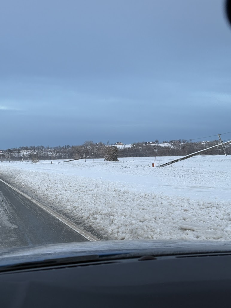
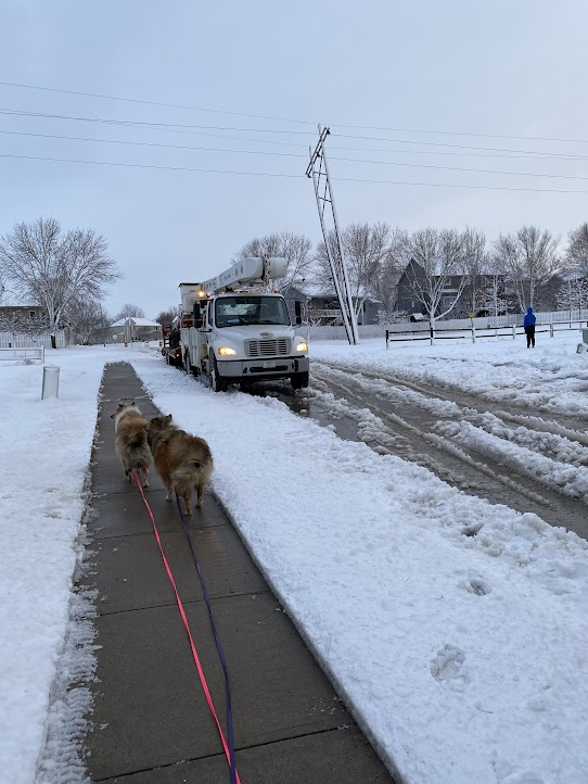
Photos & Video
 |
 |
 |
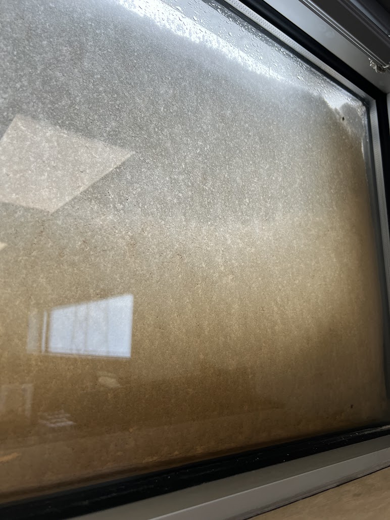 |
| Power line damage near Ceresco | Power line damage between Waterloo and Elkhorn | Leaning power poles in northwest Omaha | Dirty snow at the NWS office in Valley due to dust from Texas being ingested into the storm |
Environment
Insert synoptic summary.
| Figure 1: Caption | Figure 2: Caption | Figure 3: Caption |
Near-storm environment summary.
| Figure 4: Caption | Figure 5: Caption | Figure 6: Caption |
Additional environmental data.
| Figure 7: Caption | Figure 8: Caption | Figure 9: Caption |
Additional Information
The Forecast
 |
 |
 |
 |
| First Graphic Discussing the Potential | Initial Winter Storm Watch for Blizzard Conditions | Initial Blizzard Warning and Winter Weather Advisory | Snowfall Forecast the Morning of March 18 |
 |
 |
 |
 |
| Updated Snowfall Forecast the Afternoon of March 18 | Probability for 4" and 6" | Road Conditions the Morning of March 19 | Road conditions the Afternoon of March 19 |
Summaries from other NWS Offices
 |
Media use of NWS Web News Stories is encouraged! Please acknowledge the NWS as the source of any news information accessed from this site. |
|

