Heat expands across the Desert Southwest, Plains, Mississippi Valley and Midwest into Monday. Fire weather concerns continue for portions of the Intermountain West. Active monsoonal moisture fuels thunderstorms over the Southwest with possible flash flooding. Tropical cyclone Fausto in the Pacific, should weaken as it approaches Hawaii; Dangerous surf, swells and rip currents are expected. Read More >
Overview
|
A line of strong to severe thunderstorms moved through portions of eastern Nebraska and southwest Iowa during the evening of May 6th, 2024. Four tornadoes were reported; three of which were rated EF-1, and one EF-0. Notably, one of these tornadoes tracked approximately one mile southeast of an EF-3 tornado that occurred near Minden, IA, just 10 days earlier on April 26th. Other severe weather reports included damaging straight-line wind gusts up 71 mph and hail up to 1.5" in diameter. |
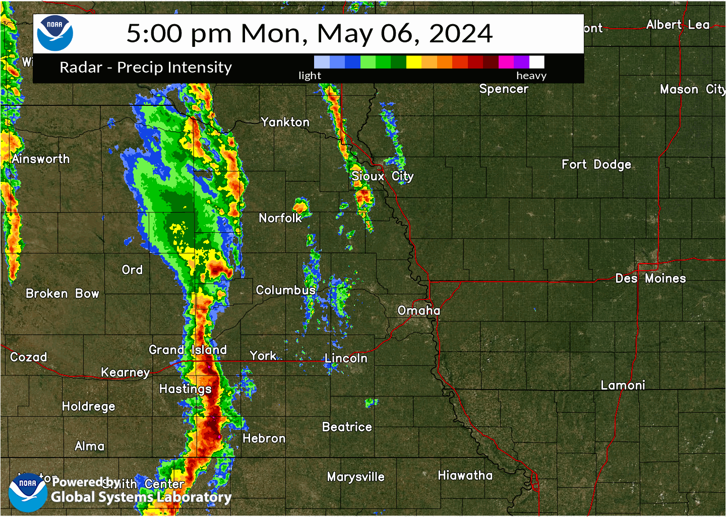 Base reflectivity radar loop of the strong to severe storms that moved through eastern Nebraska and southwest Iowa during the evening hours of May 6th, 2024. |
Tornadoes
|
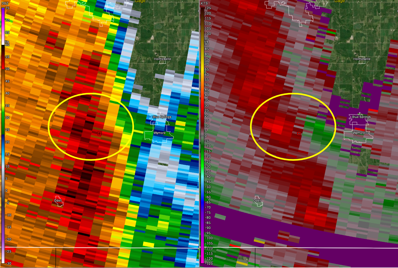
Tornado - Wymore, NE Area
Track Map 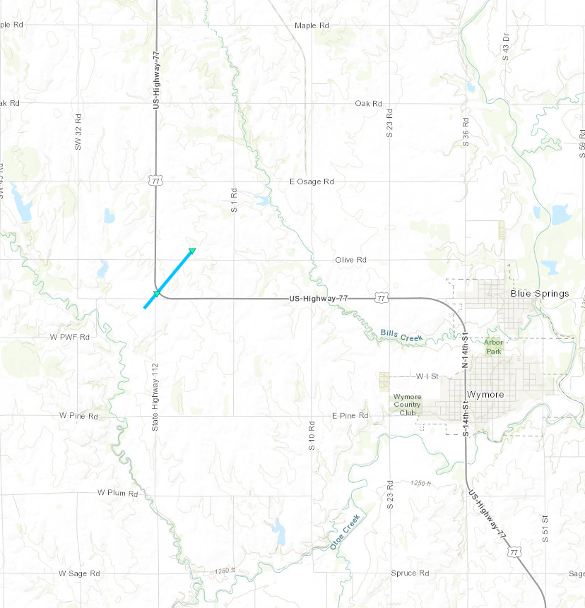  |
||||||||||||||||
|
||||||||||||||||
|
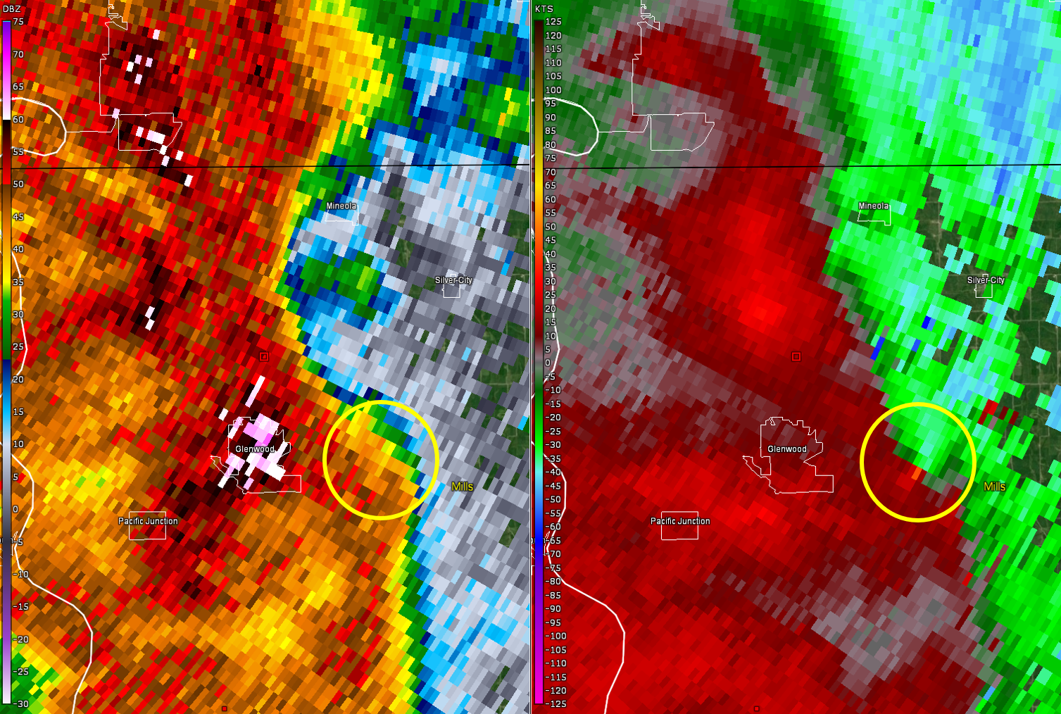
Tornado - Glenwood, IA Area
Track Map 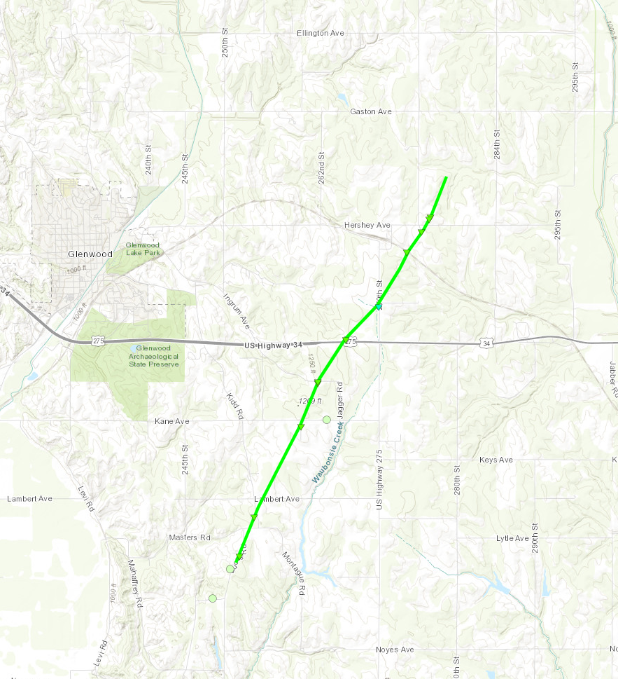 |
||||||||||||||||
|
||||||||||||||||
|
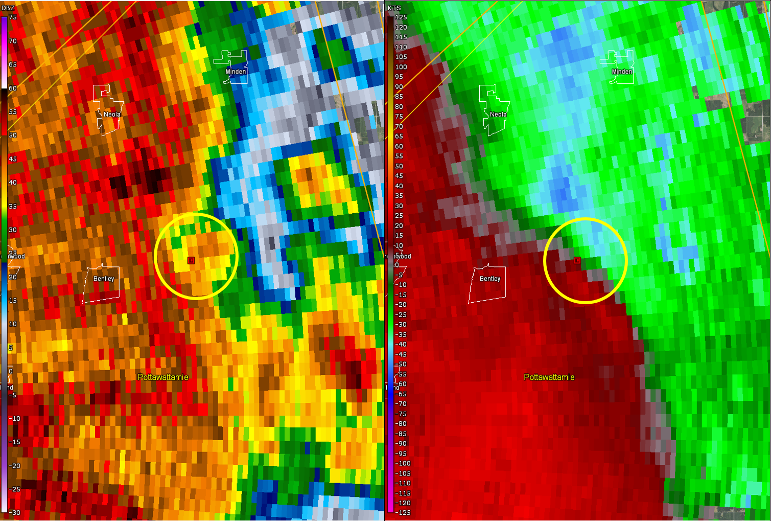
Tornado - Carson/Macedonia, IA Area
Track Map 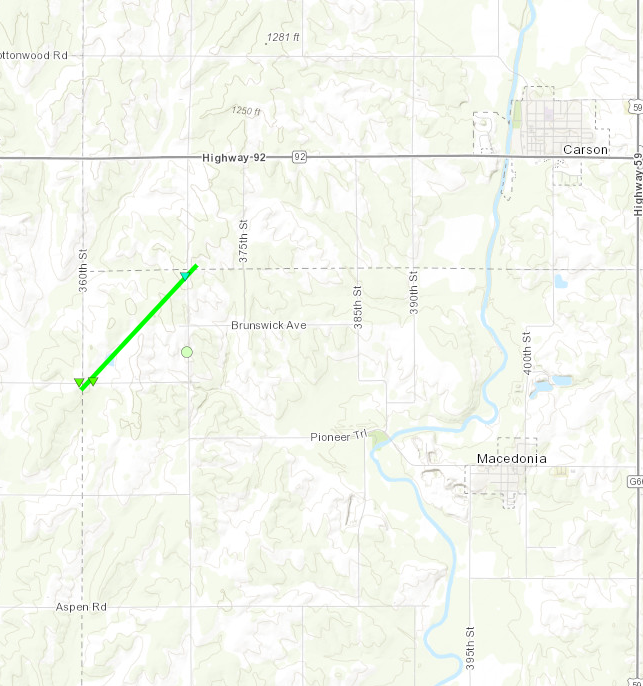 |
||||||||||||||||
|
||||||||||||||||
|
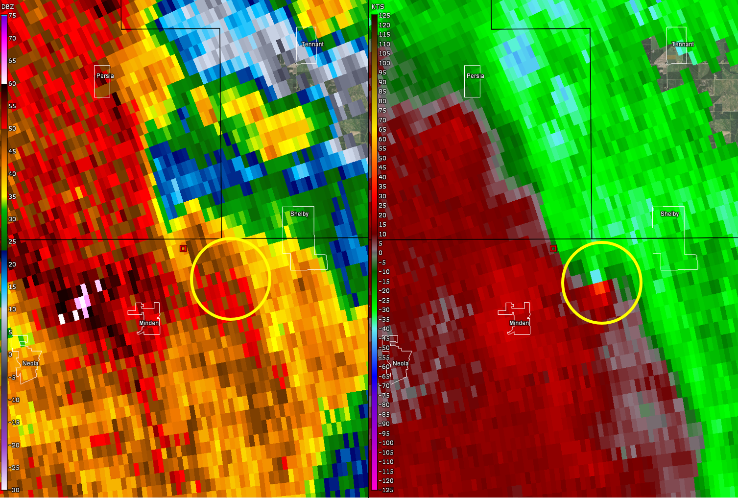
Tornado - Minden/Shelby, IA Area
Track Map 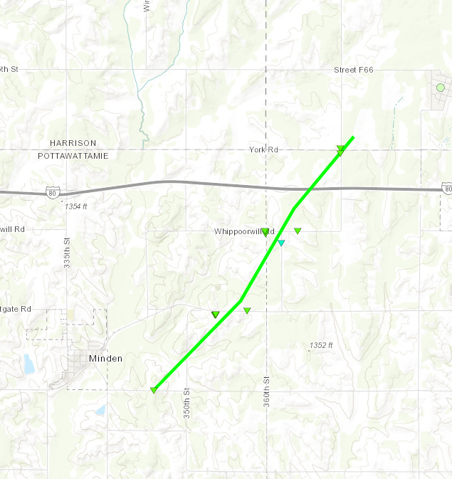 |
||||||||||||||||
|
||||||||||||||||
The Enhanced Fujita (EF) Scale classifies tornadoes into the following categories:
| EF0 Weak 65-85 mph |
EF1 Moderate 86-110 mph |
EF2 Significant 111-135 mph |
EF3 Severe 136-165 mph |
EF4 Extreme 166-200 mph |
EF5 Catastrophic 200+ mph |
 |
|||||
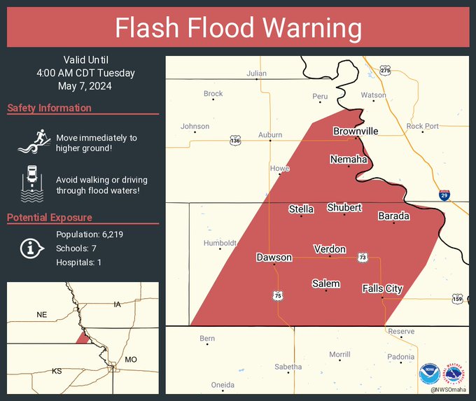
Flooding
Warnings
 |
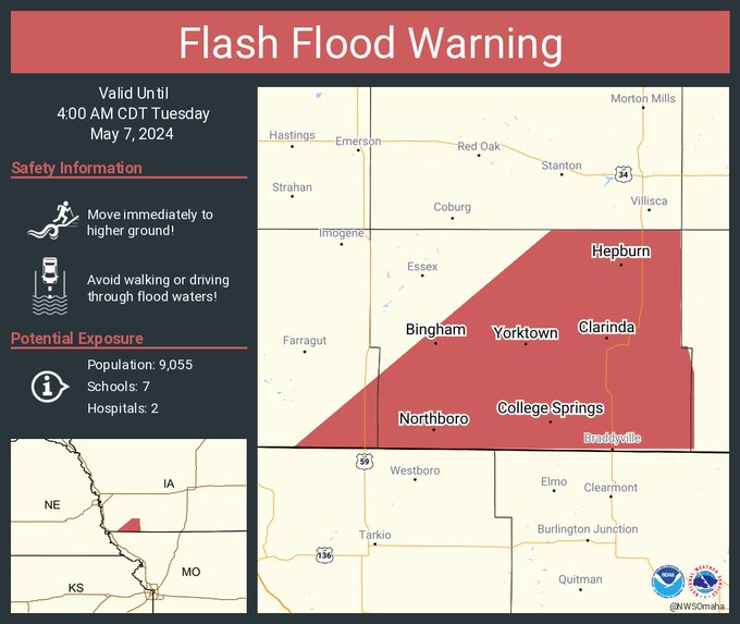 |
| Flash Flood Warning issued for far southeast Nebraska | Flash Flood Warning issued for far southwest Iowa |
Photos & Video
Header
| Caption (source) |
Caption (source) |
Caption (source) |
Caption (source) |
Storm Reports
..TIME...   ...EVENT...      ...CITY LOCATION...     ...LAT.LON...
..DATE...   ....MAG....      ..COUNTY LOCATION..ST.. ...SOURCE....
            ..REMARKS..

1200 AM     Tstm Wnd Gst     4 WNW Daykin            40.34N 97.37W
05/04/2024  M52 MPH          Jefferson          NE   Public

            Report measured from a public weather
            station.

0707 PM     Tornado          4 WNW Wymore            40.14N 96.75W
05/06/2024                   Gage               NE   NWS Storm Survey

            Storm spotters provided video matching up
            with a short damage path. The EF-0 tornado
            damaged the hoop building that stores road
            supplies along highway 77, proceeded
            northeast where it broke some tree branches
            and quickly dissipated.

0830 PM     Tstm Wnd Dmg     Millard                 41.21N 96.15W
05/06/2024                   Douglas            NE   Public

            4 inch tree limbs blown down. Time estimated
            from radar. Delayed report.

0907 PM     Tornado          4 W Macedonia           41.20N 95.50W
05/06/2024                   Pottawattamie      IA   NWS Storm Survey

            Brief EF-1 tornado damage was observed 4
            miles west/northwest of Macedonia where two
            large trees were snapped and then lifted
            about a mile northeast of where one home
            sustained shingle damage.

0913 PM     Tornado          1 ESE Minden            41.46N 95.52W
05/06/2024                   Pottawattamie      IA   NWS Storm Survey

            This EF1 tornado touched down at 9:10pm 2
            miles southeast of Minden causing EF1 damage
            to a transmission line. It then traveled
            northeast and damaged outbuildings and broke
            a window on the south side of a home along
            Tamarack Road. In addition, power poles were
            snapped along Tamarack Road to the northeast
            of this home. Tree damage continued
            northeast to the Avoca Rest Area where it
            crossed I-80. The tornado then continued
            northeast a half-mile before lifting north
            of the intersection of York Rd and Elmwood
            Rd. There was tree damage on the west side
            of Shelby as the storm continued northeast
            but there was no evidence of tornado damage
            in Shelby.

0930 PM     Tstm Wnd Dmg     4 SSW Walnut            41.42N 95.25W
05/06/2024                   Pottawattamie      IA   Public

            Empty grain bin blown off its foundation.
            Time estimated from radar.

0848 PM     Tornado          4 SSE Glenwood          40.99N 95.71W
05/06/2024                   Mills              IA   NWS Storm Survey

            An EF-1 tornado developed and snapped trees
            at a home on Lucas Road, moving quickly to
            the northeast where it cut a 30 yard wide
            swath of snapped trees and branches.
            Additional sporadic tree damage was noted
            near Kane Avenue. A farm was badly damaged
            along Jagger Road, with one large shed
            completely destroyed and two large grain
            bins destroyed with debris deposited a half
            mile downstream. The tornado then crossed
            Highway 34 a quarter-mile west of 270th
            street damaging a power pole. Damage
            continued northeast through open fields
            crossing the Burlington Northern Santa Fe
            line where large tree branches were snapped.
            The tornado continued northeast damaging two
            farmsteads along Hershey Ave where several
            outbuildings sustained high-end EF1 damage.
            Many trees were snapped at both farmsteads.

0834 PM     Hail             3 SE Chalco             41.14N 96.11W
05/06/2024  M1.00 Inch       Sarpy              NE   Public

            Report from mPING: Quarter (1.00 in.).

0835 PM     Hail             3 SSE Papillion         41.12N 96.02W
05/06/2024  M1.50 Inch       Sarpy              NE   Public


0840 PM     Tstm Wnd Dmg     Bellevue                41.16N 95.92W
05/06/2024                   Sarpy              NE   Public

            Tree snapped and fell on a home.

0830 PM     Tstm Wnd Gst     2 N Humboldt            40.20N 95.94W
05/06/2024  M71 MPH          Richardson         NE   Trained Spotter


0813 PM     Tstm Wnd Gst     Steinauer               40.21N 96.23W
05/06/2024  E60 MPH          Pawnee             NE   Fire Dept/Rescue

            Relayed by Emergency Management.

0837 PM     Tstm Wnd Gst     5 S Nebraska City       40.61N 95.87W
05/06/2024  E60 MPH          Otoe               NE   Emergency Mngr


0852 PM     Tstm Wnd Gst     3 WSW Nemaha            40.32N 95.73W
05/06/2024  M64 MPH          Nemaha             NE   Public

            From a personal weather station.

0720 PM     Tstm Wnd Dmg     4 SSE Pickrell          40.32N 96.69W
05/06/2024                   Gage               NE   Emergency Mngr

            Damage to a residence, downed power lines.

0730 PM     Hail             5 WSW Virginia          40.22N 96.58W
05/06/2024  E0.88 Inch       Gage               NE   Public


0831 PM     Hail             3 NE Elkhorn            41.31N 96.21W
05/06/2024  M1.00 Inch       Douglas            NE   Public

            Report from mPING: Quarter (1.00 in.).

0740 PM     Tstm Wnd Dmg     2 NW Fremont            41.46N 96.52W
05/06/2024                   Dodge              NE   Public

            Report from mPING: 1-inch tree limbs broken;
            Shingles blown off.

0803 PM     Tstm Wnd Gst     3 WSW Murdock           40.91N 96.34W
05/06/2024  M54 MPH          Cass               NE   Public

            From a personal weather station.

0813 PM     Tstm Wnd Gst     3 S South Bend          40.96N 96.24W
05/06/2024  E60 MPH          Cass               NE   Emergency Mngr

            At 334 and Church Road.

0837 PM     Tstm Wnd Dmg     Plattsmouth             41.01N 95.89W
05/06/2024                   Cass               NE   Emergency Mngr

            Plattsmouth without power.

0849 PM     Tstm Wnd Dmg     3 E Murray              40.93N 95.88W
05/06/2024                   Cass               NE   Public

            Report from mPING: 1-inch tree limbs broken;
            Shingles blown off.

0921 PM     Tstm Wnd Gst     1 NNW Shelby            41.53N 95.46W
05/06/2024  M67 MPH          Shelby             IA   Public

            From a personal weather station.

0931 PM     Tstm Wnd Gst     1 NW Harlan             41.66N 95.34W
05/06/2024  M65 MPH          Shelby             IA   Public

            From a personal weather station.

0858 PM     Tstm Wnd Gst     5 WSW Mcclelland        41.30N 95.77W
05/06/2024  M65 MPH          Pottawattamie      IA   Public

            From a personal weather station.

0859 PM     Tstm Wnd Gst     4 SW Mcclelland         41.28N 95.73W
05/06/2024  M65 MPH          Pottawattamie      IA   Public

            From a personal weather station.

0908 PM     Tstm Wnd Dmg     4 WNW Macedonia         41.20N 95.50W
05/06/2024                   Pottawattamie      IA   Emergency Mngr

            Large tree snapped. Several additional trees
            sheared off the top.

0908 PM     Tstm Wnd Dmg     6 SSE Minden            41.38N 95.52W
05/06/2024                   Pottawattamie      IA   Emergency Mngr

            High tension power lines blown down.

0908 PM     Tstm Wnd Dmg     6 SSE Minden            41.38N 95.52W
05/06/2024                   Pottawattamie      IA   Emergency Mngr

            High tension powerlines blown down.

0914 PM     Tstm Wnd Dmg     1 ESE Minden            41.46N 95.52W
05/06/2024                   Pottawattamie      IA   Emergency Mngr

            Power lines across the road. Possible damage
            to a residence likely from a tornado.

0916 PM     Tstm Wnd Dmg     2 ENE Minden            41.48N 95.51W
05/06/2024                   Pottawattamie      IA   Emergency Mngr

            Damage to a residence, likely from a
            tornado.

0917 PM     Tstm Wnd Dmg     3 ENE Minden            41.48N 95.49W
05/06/2024                   Pottawattamie      IA   Emergency Mngr

            Power poles snapped. Likely from a tornado.

0919 PM     Tstm Wnd Gst     1 E Oakland             41.31N 95.38W
05/06/2024  M58 MPH          Pottawattamie      IA   Public

            From a personal weather station.

0852 PM     Tstm Wnd Dmg     4 E Glenwood            41.05N 95.66W
05/06/2024                   Mills              IA   Emergency Mngr

            Damage to a home and multiple outbuildings.

0905 PM     Tstm Wnd Gst     1 S Hastings            41.00N 95.50W
05/06/2024  M58 MPH          Mills              IA   Public

            From a personal weather station.


&&
 |
Media use of NWS Web News Stories is encouraged! Please acknowledge the NWS as the source of any news information accessed from this site. |
|