|
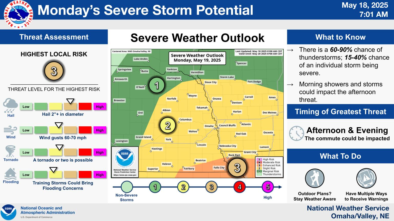
Local WWA Map
|
Local Radar
|
Omaha Weather Story
|
|
National WWA Map
|
QPF Day 1
|
Local QPF Day 1
|
|
SPC Day 1
|
Local Severe Day 1
|
Storm Total Snow Forecast
|
NPW | WSW | WCN | SVR | TOR | SVS | LSR | FFW | FFS | FLW | FLS
CLIOMA | CLILNK | CLIOFK | CLIOAX | RTPOAX | RWRNE | RWRIA
Area Forecast Discussion
205
FXUS63 KOAX 211715
AFDOAX

Area Forecast Discussion
National Weather Service Omaha/Valley NE
1215 PM CDT Thu May 21 2026

.KEY MESSAGES...

- Light showers are possible overnight (30-60% chance), mainly
  across southeast Nebraska and southwest Iowa.

- Widespread showers and few thunderstorms are expected Thursday
  night into Friday. Severe weather is not expected.

- Temperatures trend warmer this weekend, with mostly dry
  conditions expected for the holiday weekend.

&&

.DISCUSSION...
Issued at 1134 PM CDT Wed May 20 2026

Tonight through Friday...

Water vapor imagery and objective analysis show weak troughing
across the western and central CONUS, resulting in generally
southwesterly flow aloft across the region. Increasing moisture
advection tonight will bring a 30-60% chance of rain to areas mainly
south of Interstate-80. Showers should remain light, with rainfall
amounts limited to a few hundredths of an inch. A small pocket of
MUCAPE will also bring a few rumbles of thunder into the
area. Overnight lows are expected to fall into the 40s.

Cloud cover and cooler conditions will persist through Thursday,
with highs only reaching the low to mid 60s, about 10 to 15 degrees
cooler than seasonal norms. A brief lull in precipitation chances is
expected Thursday afternoon and evening before becoming more
widespread Thursday night into Friday as a shortwave disturbance
pivots across the Front Range into the northern Plains. PoPs peak at
75-95% late Friday morning. Additional spotty showers and
thunderstorms are expected later in the day as a cold front pushes
through. There appears to be enough instability for a few rumbles of
thunder, but severe weather is not expected. Rain chances will
gradually taper off Friday afternoon and evening, with highs again
topping out in the low to mid 60s. Latest NBM guidance shows a
widespread 70-90% probability for at least 0.25 inch of
precipitation, along with a 40-70% probability of at least 0.50 inch
through the period.

Saturday and Beyond...

A warming trend will take hold through the weekend as mid-level
ridging and surface high pressure builds into the region. Highs will
climb into the low 70s on Saturday, low 80s on Sunday, and generally
the mid 80s from Memorial Day into the start of next week. The
weekend looks mostly dry. Confidence in the large-scale pattern
decreases through the remainder of next week. Long-range guidance
suggests a trough may move in from the western CONUS by mid to late
week, though considerable spread remains in the timing and track of
this features, leading to uncertainty in any additional
precipitation chances. For now, periodic 15-30% PoPs persist through
much of the work week.

&&

.AVIATION /18Z TAFS THROUGH 18Z FRIDAY/...
Issued at 1204 PM CDT Thu May 21 2026

VFR conditions are expected this afternoon with peaks of sun and
scattered cumulus between 3-5 kft. Denser mid to high level
clouds linger across southern portions of the area during this
time. A weather system approaches the region this evening.
Ceilings will gradually fall as this occurs. MVFR ceilings are
anticipated this evening at OFK and LNK with OMA expected to
fall later tonight. IFR ceilings will likely follow at OFK and
LNK tonight. Rain coincides with the decreasing ceilings, likely
restricting visibility to MVFR at times. A rumble of thunder
can`t be ruled out, but the best chance of thunderstorms does
not arrive until Friday afternoon. Winds remain mostly light at
the east-southeast through the forecast period.

&&

.OAX WATCHES/WARNINGS/ADVISORIES...
NE...None.
IA...None.

&&

$$

DISCUSSION...Wood
AVIATION...Chehak
Hazardous Weather Outlook
008
FLUS43 KOAX 211058
HWOOAX

Hazardous Weather Outlook
National Weather Service Omaha/Valley NE
558 AM CDT Thu May 21 2026

IAZ043-055-056-069-079-080-090-091-NEZ011-012-015>018-030>034-
042>045-050>053-065>068-078-088>093-221100-
Monona-Harrison-Shelby-Pottawattamie-Mills-Montgomery-Fremont-Page-
Knox-Cedar-Thurston-Antelope-Pierce-Wayne-Boone-Madison-Stanton-
Cuming-Burt-Platte-Colfax-Dodge-Washington-Butler-Saunders-Douglas-
Sarpy-Seward-Lancaster-Cass-Otoe-Saline-Jefferson-Gage-Johnson-
Nemaha-Pawnee-Richardson-
558 AM CDT Thu May 21 2026

This Hazardous Weather Outlook is for southwest Iowa, west central
Iowa, east central Nebraska, northeast Nebraska and southeast
Nebraska.

.DAY ONE...Today and tonight.

The probability for widespread hazardous weather is low.

.DAYS TWO THROUGH SEVEN...Friday through Wednesday.

The probability for widespread hazardous weather is low.

.SPOTTER INFORMATION STATEMENT...

Spotter activation is not expected at this time.

$$
Zone Forecast
124
FPUS53 KOAX 211619
ZFPOAX

Zone Forecasts for Eastern Nebraska and Southwest Iowa for Nebraska
National Weather Service Omaha/Valley NE
1119 AM CDT Thu May 21 2026

NEZ052-220000-
Douglas-
Including the city of Omaha
1119 AM CDT Thu May 21 2026

.THIS AFTERNOON...Mostly cloudy. Near steady temperature around
60. Southeast winds 5 to 10 mph.
.TONIGHT...Cloudy. A chance of showers with a slight chance of
thunderstorms in the evening, then showers likely with a chance
of thunderstorms after midnight. Lows in the upper 40s. East
winds 10 to 15 mph. Chance of rain 70 percent.
.FRIDAY...A chance of thunderstorms. Showers. Highs in the mid
60s. Southeast winds 10 to 15 mph with gusts up to 25 mph. Chance
of rain 90 percent.
.FRIDAY NIGHT...Showers with a chance of thunderstorms in the
evening, then showers likely after midnight. Lows in the upper
40s. Southwest winds 5 to 10 mph. Chance of rain 90 percent.
.SATURDAY...Partly sunny. Highs in the lower 70s. Northwest winds
around 5 mph.
.SATURDAY NIGHT...Partly cloudy in the evening, then clearing.
Lows in the lower 50s.
.SUNDAY...Sunny. Highs around 80.
.SUNDAY NIGHT...Mostly clear. Lows in the mid 50s.
.MEMORIAL DAY...Sunny. Highs in the mid 80s.
.MONDAY NIGHT...Mostly clear. Lows in the upper 50s.
.TUESDAY...Mostly sunny. Highs in the mid 80s.
.TUESDAY NIGHT...Mostly cloudy in the evening, then becoming
partly cloudy. A slight chance of showers and thunderstorms. Lows
in the lower 60s. Chance of rain 20 percent.
.WEDNESDAY...Partly sunny. A slight chance of showers and
thunderstorms in the morning, then a chance of showers and
thunderstorms in the afternoon. Highs in the mid 80s. Chance of
rain 30 percent.

$$

NEZ053-220000-
Sarpy-
Including the cities of Bellevue, Papillion, and La Vista
1119 AM CDT Thu May 21 2026

.THIS AFTERNOON...Mostly cloudy. Near steady temperature around
60. East winds 5 to 10 mph.
.TONIGHT...Cloudy. A chance of showers with a slight chance of
thunderstorms in the evening, then showers likely with a chance
of thunderstorms after midnight. Lows in the upper 40s. East
winds 5 to 10 mph. Chance of rain 70 percent.
.FRIDAY...Showers likely with a chance of thunderstorms. Highs in
the mid 60s. Southeast winds 10 to 15 mph with gusts up to
25 mph. Chance of rain 70 percent.
.FRIDAY NIGHT...A chance of thunderstorms in the evening. Showers
likely. Lows around 50. Southwest winds 5 to 10 mph. Chance of
rain 70 percent.
.SATURDAY...Partly sunny. Highs in the lower 70s. Northwest winds
around 5 mph.
.SATURDAY NIGHT...Partly cloudy. Lows in the lower 50s.
.SUNDAY...Sunny. Highs in the upper 70s.
.SUNDAY NIGHT...Mostly clear. Lows in the mid 50s.
.MEMORIAL DAY...Sunny. Highs in the mid 80s.
.MONDAY NIGHT...Mostly clear in the evening, then becoming partly
cloudy. Lows in the upper 50s.
.TUESDAY...Mostly sunny. Highs in the lower 80s.
.TUESDAY NIGHT...Mostly cloudy in the evening, then becoming
partly cloudy. A slight chance of showers and thunderstorms. Lows
in the lower 60s. Chance of rain 20 percent.
.WEDNESDAY...Partly sunny. A slight chance of showers and
thunderstorms in the morning, then a chance of showers and
thunderstorms in the afternoon. Highs in the mid 80s. Chance of
rain 30 percent.

$$

IAZ069-220000-
Pottawattamie-
Including the city of Council Bluffs
1119 AM CDT Thu May 21 2026

.THIS AFTERNOON...Mostly cloudy. Near steady temperature in the
upper 50s. East winds 10 to 15 mph with gusts up to 25 mph.
.TONIGHT...Cloudy. A chance of showers with a slight chance of
thunderstorms after midnight. Lows in the upper 40s. East winds
10 to 15 mph. Chance of rain 50 percent.
.FRIDAY...Showers likely. A slight chance of thunderstorms in the
morning, then a chance of thunderstorms in the afternoon. Highs
in the mid 60s. Southeast winds 15 to 20 mph. Chance of rain
70 percent.
.FRIDAY NIGHT...Showers with a chance of thunderstorms in the
evening, then showers likely with a slight chance of
thunderstorms after midnight. Lows around 50. South winds 10 to
15 mph, becoming southwest around 5 mph after midnight. Chance of
rain 90 percent.
.SATURDAY...Partly sunny. Highs in the lower 70s. Northwest winds
5 to 10 mph.
.SATURDAY NIGHT...Partly cloudy. Lows around 50.
.SUNDAY...Sunny. Highs in the upper 70s.
.SUNDAY NIGHT...Mostly clear. Lows in the mid 50s.
.MEMORIAL DAY...Sunny. Highs in the mid 80s.
.MONDAY NIGHT...Mostly clear in the evening, then becoming partly
cloudy. Lows in the upper 50s.
.TUESDAY...Mostly sunny. Highs in the mid 80s.
.TUESDAY NIGHT...Mostly cloudy with a slight chance of showers
and thunderstorms. Lows in the lower 60s. Chance of rain
20 percent.
.WEDNESDAY...Partly sunny. A slight chance of showers and
thunderstorms in the morning, then a chance of showers and
thunderstorms in the afternoon. Highs in the mid 80s. Chance of
rain 40 percent.

$$

NEZ066-220000-
Lancaster-
Including the city of Lincoln
1119 AM CDT Thu May 21 2026

.THIS AFTERNOON...Partly sunny early, then becoming mostly
cloudy. Near steady temperature around 60. East winds 10 to
15 mph with gusts up to 25 mph.
.TONIGHT...Cloudy. A chance of showers with a slight chance of
thunderstorms in the evening, then showers likely with a chance
of thunderstorms after midnight. Lows in the lower 50s. East
winds 10 to 15 mph with gusts up to 25 mph. Chance of rain
70 percent.
.FRIDAY...A chance of thunderstorms. Showers. Highs in the upper
60s. South winds 10 to 15 mph with gusts up to 25 mph. Chance of
rain 90 percent.
.FRIDAY NIGHT...Mostly cloudy in the evening, then becoming
partly cloudy. A chance of thunderstorms in the evening. A chance
of showers. Lows in the upper 40s. West winds 5 to 10 mph. Chance
of rain 50 percent.
.SATURDAY...Partly sunny. Highs in the lower 70s. Northwest winds
5 to 10 mph.
.SATURDAY NIGHT...Partly cloudy. Lows around 50.
.SUNDAY...Sunny. Highs around 80.
.SUNDAY NIGHT...Mostly clear. Lows in the mid 50s.
.MEMORIAL DAY...Sunny. Highs in the mid 80s.
.MONDAY NIGHT...Mostly clear. Lows in the upper 50s.
.TUESDAY...Mostly sunny. Highs in the lower 80s.
.TUESDAY NIGHT...Mostly cloudy in the evening, then becoming
partly cloudy. A slight chance of showers and thunderstorms. Lows
around 60. Chance of rain 20 percent.
.WEDNESDAY...Partly sunny. A slight chance of showers and
thunderstorms in the morning, then a chance of showers and
thunderstorms in the afternoon. Highs in the mid 80s. Chance of
rain 40 percent.

$$

NEZ031-220000-
Madison-
Including the city of Norfolk
1119 AM CDT Thu May 21 2026

.THIS AFTERNOON...Mostly sunny. Highs in the mid 60s. Southeast
winds 10 to 15 mph.
.TONIGHT...Showers likely with a slight chance of thunderstorms
in the evening, then showers with a chance of thunderstorms after
midnight. Lows in the mid 40s. Southeast winds 10 to 15 mph with
gusts up to 25 mph. Chance of rain 90 percent.
.FRIDAY...Showers with a chance of thunderstorms in the morning,
then a chance of showers with a slight chance of thunderstorms in
the afternoon. Highs in the lower 60s. Southeast winds around
15 mph, becoming southwest in the afternoon. Gusts up to 30 mph.
Chance of rain near 100 percent.
.FRIDAY NIGHT...Partly cloudy. A chance of showers after
midnight. Lows in the lower 40s. West winds 10 to 15 mph,
diminishing to around 5 mph after midnight. Chance of rain
30 percent.
.SATURDAY...Partly sunny. Highs in the lower 70s. Northwest winds
around 5 mph.
.SATURDAY NIGHT...Partly cloudy in the evening, then clearing.
Lows in the upper 40s.
.SUNDAY...Sunny. Highs around 80.
.SUNDAY NIGHT...Mostly clear. Lows in the mid 50s.
.MEMORIAL DAY...Sunny. Highs in the mid 80s.
.MONDAY NIGHT...Mostly clear. Lows in the mid 50s.
.TUESDAY...Mostly sunny. Highs in the mid 80s.
.TUESDAY NIGHT...Partly cloudy. Lows in the upper 50s.
.WEDNESDAY...Mostly cloudy in the morning, then partly sunny with
a slight chance of showers and thunderstorms in the afternoon.
Highs in the lower 80s. Chance of rain 20 percent.

$$

NEZ011-220000-
Knox-
Including the cities of Creighton, Bloomfield, Crofton, Wausa,
Verdigre, and Niobrara
1119 AM CDT Thu May 21 2026

.THIS AFTERNOON...Sunny. Highs in the upper 60s. Southeast winds
around 10 mph, increasing to 15 to 20 mph.
.TONIGHT...Cloudy. A chance of showers in the evening, then
showers with a slight chance of thunderstorms after midnight.
Lows in the mid 40s. Southeast winds 15 to 20 mph. Chance of rain
90 percent.
.FRIDAY...Showers with a slight chance of thunderstorms in the
morning, then a chance of showers in the afternoon. Highs in the
lower 60s. Southeast winds 15 to 20 mph, becoming southwest in
the afternoon. Chance of rain near 100 percent.
.FRIDAY NIGHT...Partly cloudy. A chance of showers after
midnight. Lows in the mid 40s. West winds 10 to 15 mph. Chance of
rain 30 percent.
.SATURDAY...Partly sunny. Warmer with highs in the lower 70s.
Northwest winds 5 to 10 mph.
.SATURDAY NIGHT...Partly cloudy in the evening, then clearing.
Lows in the upper 40s.
.SUNDAY...Sunny, warmer with highs in the lower 80s.
.SUNDAY NIGHT...Mostly clear. Lows in the mid 50s.
.MEMORIAL DAY...Sunny. Highs in the upper 80s.
.MONDAY NIGHT...Mostly clear. Lows in the upper 50s.
.TUESDAY...Mostly sunny. Highs in the upper 80s.
.TUESDAY NIGHT...Partly cloudy. Lows in the upper 50s.
.WEDNESDAY...Partly sunny with a slight chance of showers. A
slight chance of thunderstorms in the afternoon. Highs in the mid
80s. Chance of rain 20 percent.

$$

NEZ012-220000-
Cedar-
Including the cities of Hartington, Laurel, Randolph,
and Coleridge
1119 AM CDT Thu May 21 2026

.THIS AFTERNOON...Mostly sunny. Highs in the upper 60s. Southeast
winds 15 to 20 mph.
.TONIGHT...Cloudy. A slight chance of showers in the evening,
then showers with a slight chance of thunderstorms after
midnight. Lows in the mid 40s. Southeast winds 15 to 20 mph with
gusts up to 30 mph. Chance of rain 90 percent.
.FRIDAY...A slight chance of thunderstorms. Showers. Highs in the
lower 60s. Southeast winds 15 to 20 mph, becoming south in the
afternoon. Gusts up to 35 mph. Chance of rain near 100 percent.
.FRIDAY NIGHT...Partly cloudy in the evening, then mostly cloudy
with a chance of showers after midnight. Lows in the mid 40s.
West winds 10 to 15 mph. Chance of rain 40 percent.
.SATURDAY...Partly sunny. Warmer with highs in the lower 70s.
Northwest winds 5 to 10 mph.
.SATURDAY NIGHT...Partly cloudy in the evening, then clearing.
Lows in the upper 40s.
.SUNDAY...Sunny, warmer with highs in the lower 80s.
.SUNDAY NIGHT...Mostly clear. Lows in the mid 50s.
.MEMORIAL DAY...Sunny. Highs in the upper 80s.
.MONDAY NIGHT...Mostly clear. Lows in the upper 50s.
.TUESDAY...Mostly sunny. Highs in the mid 80s.
.TUESDAY NIGHT...Partly cloudy. Lows in the upper 50s.
.WEDNESDAY...Partly sunny. A slight chance of showers and
thunderstorms in the afternoon. Highs in the mid 80s. Chance of
rain 20 percent.

$$

NEZ016-220000-
Antelope-
Including the cities of Neligh and Elgin
1119 AM CDT Thu May 21 2026

.THIS AFTERNOON...Mostly sunny. Highs in the mid 60s. Southeast
winds 10 to 15 mph with gusts up to 25 mph.
.TONIGHT...A chance of showers with a slight chance of
thunderstorms in the evening, then showers with a chance of
thunderstorms after midnight. Lows in the mid 40s. Southeast
winds 10 to 15 mph with gusts up to 25 mph. Chance of rain near
100 percent.
.FRIDAY...Showers with a chance of thunderstorms in the morning,
then partly sunny with a chance of showers in the afternoon.
Highs in the lower 60s. Southeast winds around 15 mph, becoming
southwest in the afternoon. Chance of rain near 100 percent.
.FRIDAY NIGHT...Partly cloudy. Lows in the lower 40s. West winds
10 to 15 mph, diminishing to around 5 mph after midnight.
.SATURDAY...Partly sunny. Highs in the lower 70s. Northwest winds
5 to 10 mph.
.SATURDAY NIGHT...Partly cloudy in the evening, then clearing.
Lows in the upper 40s.
.SUNDAY...Sunny. Highs in the lower 80s.
.SUNDAY NIGHT...Mostly clear. Lows in the mid 50s.
.MEMORIAL DAY...Sunny. Highs in the mid 80s.
.MONDAY NIGHT...Mostly clear. Lows in the upper 50s.
.TUESDAY...Mostly sunny. Highs in the mid 80s.
.TUESDAY NIGHT...Partly cloudy. Lows in the upper 50s.
.WEDNESDAY...Partly sunny. A slight chance of showers and
thunderstorms in the afternoon. Highs in the mid 80s. Chance of
rain 20 percent.

$$

NEZ017-220000-
Pierce-
Including the cities of Pierce, Plainview, and Osmond
1119 AM CDT Thu May 21 2026

.THIS AFTERNOON...Mostly sunny. Highs in the upper 60s. Southeast
winds around 10 mph, increasing to 15 to 20 mph.
.TONIGHT...Cloudy. A chance of showers with a slight chance of
thunderstorms in the evening, then showers with a chance of
thunderstorms after midnight. Lows in the mid 40s. Southeast
winds 15 to 20 mph. Chance of rain 90 percent.
.FRIDAY...Showers with a chance of thunderstorms in the morning,
then a chance of showers with a slight chance of thunderstorms in
the afternoon. Highs in the lower 60s. Southeast winds 15 to
20 mph, becoming southwest in the afternoon. Chance of rain near
100 percent.
.FRIDAY NIGHT...Partly cloudy. A chance of showers after
midnight. Lows in the mid 40s. West winds 10 to 15 mph with gusts
up to 25 mph, diminishing to around 5 mph after midnight. Chance
of rain 30 percent.
.SATURDAY...Partly sunny. Highs in the lower 70s. Northwest winds
5 to 10 mph.
.SATURDAY NIGHT...Partly cloudy in the evening, then clearing.
Lows in the upper 40s.
.SUNDAY...Sunny. Highs in the lower 80s.
.SUNDAY NIGHT...Mostly clear. Lows in the mid 50s.
.MEMORIAL DAY...Sunny. Highs in the mid 80s.
.MONDAY NIGHT...Mostly clear. Lows in the upper 50s.
.TUESDAY...Mostly sunny. Highs in the mid 80s.
.TUESDAY NIGHT...Partly cloudy. Lows in the upper 50s.
.WEDNESDAY...Mostly cloudy in the morning, then partly sunny with
a slight chance of showers and thunderstorms in the afternoon.
Highs in the mid 80s. Chance of rain 20 percent.

$$

NEZ018-220000-
Wayne-
Including the city of Wayne
1119 AM CDT Thu May 21 2026

.THIS AFTERNOON...Mostly sunny. Highs in the mid 60s. Southeast
winds around 10 mph, increasing to 15 to 20 mph.
.TONIGHT...Cloudy. A chance of showers with a slight chance of
thunderstorms in the evening, then showers with a chance of
thunderstorms after midnight. Lows in the mid 40s. Southeast
winds 15 to 20 mph. Chance of rain 90 percent.
.FRIDAY...Showers with a chance of thunderstorms in the morning,
then showers likely with a slight chance of thunderstorms in the
afternoon. Highs in the lower 60s. Southeast winds 15 to 20 mph,
becoming south in the afternoon. Gusts up to 35 mph. Chance of
rain near 100 percent.
.FRIDAY NIGHT...Partly cloudy in the evening, then mostly cloudy
with a chance of showers after midnight. Lows in the mid 40s.
West winds 10 to 15 mph with gusts up to 25 mph, diminishing to
around 5 mph after midnight. Chance of rain 40 percent.
.SATURDAY...Partly sunny. Warmer with highs in the lower 70s.
Northwest winds 5 to 10 mph.
.SATURDAY NIGHT...Partly cloudy in the evening, then clearing.
Lows in the upper 40s.
.SUNDAY...Sunny. Highs in the lower 80s.
.SUNDAY NIGHT...Mostly clear. Lows in the mid 50s.
.MEMORIAL DAY...Sunny. Highs in the mid 80s.
.MONDAY NIGHT...Mostly clear. Lows in the upper 50s.
.TUESDAY...Mostly sunny. Highs in the mid 80s.
.TUESDAY NIGHT...Partly cloudy. Lows in the upper 50s.
.WEDNESDAY...Mostly cloudy in the morning, then partly sunny with
a slight chance of showers and thunderstorms in the afternoon.
Highs in the mid 80s. Chance of rain 20 percent.

$$

NEZ015-220000-
Thurston-
Including the cities of Pender, Macy, Walthill, and Winnebago
1119 AM CDT Thu May 21 2026

.THIS AFTERNOON...Partly sunny. Near steady temperature in the
lower 60s. Southeast winds around 10 mph, increasing to 15 to
20 mph.
.TONIGHT...Cloudy with a slight chance of thunderstorms. A chance
of showers in the evening, then showers after midnight. Lows in
the mid 40s. Southeast winds 15 to 20 mph. Chance of rain
90 percent.
.FRIDAY...Showers. A slight chance of thunderstorms in the
morning, then a chance of thunderstorms in the afternoon. Breezy
with highs in the lower 60s. Southeast winds 15 to 25 mph with
gusts up to 35 mph. Chance of rain near 100 percent.
.FRIDAY NIGHT...Mostly cloudy. A chance of showers and
thunderstorms in the evening, then showers likely after midnight.
Lows in the mid 40s. Southwest winds 10 to 15 mph, becoming west
around 5 mph after midnight. Chance of rain 70 percent.
.SATURDAY...Partly sunny. Warmer with highs in the lower 70s.
Northwest winds 5 to 10 mph.
.SATURDAY NIGHT...Partly cloudy. Lows in the upper 40s.
.SUNDAY...Sunny. Highs around 80.
.SUNDAY NIGHT...Mostly clear. Lows in the lower 50s.
.MEMORIAL DAY...Sunny. Highs in the mid 80s.
.MONDAY NIGHT...Mostly clear. Lows in the mid 50s.
.TUESDAY...Mostly sunny. Highs in the mid 80s.
.TUESDAY NIGHT...Partly cloudy. A slight chance of showers and
thunderstorms in the evening. Lows in the upper 50s. Chance of
rain 20 percent.
.WEDNESDAY...Mostly cloudy in the morning, then partly sunny with
a slight chance of showers and thunderstorms in the afternoon.
Highs in the mid 80s. Chance of rain 20 percent.

$$

NEZ032-220000-
Stanton-
Including the city of Stanton
1119 AM CDT Thu May 21 2026

.THIS AFTERNOON...Mostly sunny. Highs in the mid 60s. Southeast
winds around 10 mph, increasing to 15 to 20 mph.
.TONIGHT...Showers likely with a slight chance of thunderstorms
in the evening, then showers with a chance of thunderstorms after
midnight. Lows in the mid 40s. Southeast winds 10 to 15 mph with
gusts up to 25 mph. Chance of rain 90 percent.
.FRIDAY...A chance of thunderstorms. Showers. Highs in the lower
60s. Southeast winds 15 to 20 mph, becoming south in the
afternoon. Chance of rain near 100 percent.
.FRIDAY NIGHT...Partly cloudy. A chance of showers after
midnight. Lows in the mid 40s. West winds 10 to 15 mph,
diminishing to around 5 mph after midnight. Chance of rain
40 percent.
.SATURDAY...Partly sunny. Warmer with highs in the lower 70s.
Northwest winds 5 to 10 mph.
.SATURDAY NIGHT...Partly cloudy in the evening, then clearing.
Lows in the upper 40s.
.SUNDAY...Sunny. Highs in the upper 70s.
.SUNDAY NIGHT...Mostly clear. Lows in the lower 50s.
.MEMORIAL DAY...Sunny. Highs in the mid 80s.
.MONDAY NIGHT...Mostly clear. Lows in the mid 50s.
.TUESDAY...Mostly sunny. Highs in the mid 80s.
.TUESDAY NIGHT...Partly cloudy. A slight chance of showers and
thunderstorms in the evening. Lows in the upper 50s. Chance of
rain 20 percent.
.WEDNESDAY...Mostly cloudy in the morning, then partly sunny with
a slight chance of showers and thunderstorms in the afternoon.
Highs in the lower 80s. Chance of rain 20 percent.

$$

NEZ033-220000-
Cuming-
Including the cities of West Point and Wisner
1119 AM CDT Thu May 21 2026

.THIS AFTERNOON...Partly sunny. Near steady temperature in the
lower 60s. Southeast winds 15 to 20 mph.
.TONIGHT...A chance of showers with a slight chance of
thunderstorms in the evening, then showers with a chance of
thunderstorms after midnight. Lows in the mid 40s. Southeast
winds 15 to 20 mph. Chance of rain 90 percent.
.FRIDAY...Showers with a chance of thunderstorms. Breezy with
highs in the lower 60s. Southeast winds 15 to 25 mph with gusts
up to 35 mph. Chance of rain near 100 percent.
.FRIDAY NIGHT...Partly cloudy in the evening, then becoming
mostly cloudy. A 50 percent chance of showers. Lows in the mid
40s. West winds 10 to 15 mph, diminishing to around 5 mph after
midnight.
.SATURDAY...Partly sunny. Warmer with highs in the lower 70s.
Northwest winds 5 to 10 mph.
.SATURDAY NIGHT...Partly cloudy in the evening, then clearing.
Lows in the upper 40s.
.SUNDAY...Sunny. Highs around 80.
.SUNDAY NIGHT...Mostly clear. Lows in the lower 50s.
.MEMORIAL DAY...Sunny. Highs in the mid 80s.
.MONDAY NIGHT...Mostly clear. Lows in the mid 50s.
.TUESDAY...Mostly sunny. Highs in the mid 80s.
.TUESDAY NIGHT...Partly cloudy with a slight chance of showers
and thunderstorms. Lows in the upper 50s. Chance of rain
20 percent.
.WEDNESDAY...Mostly cloudy in the morning, then becoming partly
sunny. A slight chance of showers and thunderstorms. Highs in the
lower 80s. Chance of rain 20 percent.

$$

NEZ034-220000-
Burt-
Including the cities of Tekamah, Oakland, Lyons, and Decatur
1119 AM CDT Thu May 21 2026

.THIS AFTERNOON...Partly sunny. Near steady temperature in the
lower 60s. Southeast winds around 10 mph, increasing to 15 to
20 mph.
.TONIGHT...Cloudy with a slight chance of thunderstorms. A chance
of showers in the evening, then showers after midnight. Lows in
the mid 40s. East winds 15 to 20 mph. Chance of rain 80 percent.
.FRIDAY...Showers. A slight chance of thunderstorms in the
morning, then a chance of thunderstorms in the afternoon. Highs
in the lower 60s. Southeast winds 15 to 20 mph with gusts up to
35 mph. Chance of rain near 100 percent.
.FRIDAY NIGHT...Mostly cloudy. A chance of showers and
thunderstorms in the evening, then showers likely after midnight.
Lows in the mid 40s. Southwest winds 10 to 15 mph, diminishing to
around 5 mph after midnight. Chance of rain 70 percent.
.SATURDAY...Partly sunny. Warmer with highs in the lower 70s.
Northwest winds 5 to 10 mph.
.SATURDAY NIGHT...Partly cloudy in the evening, then clearing.
Lows in the upper 40s.
.SUNDAY...Sunny. Highs around 80.
.SUNDAY NIGHT...Mostly clear. Lows in the mid 50s.
.MEMORIAL DAY...Sunny. Highs in the mid 80s.
.MONDAY NIGHT...Mostly clear. Lows in the mid 50s.
.TUESDAY...Mostly sunny. Highs in the mid 80s.
.TUESDAY NIGHT...Partly cloudy with a slight chance of showers
and thunderstorms. Lows in the upper 50s. Chance of rain
20 percent.
.WEDNESDAY...Mostly cloudy in the morning, then becoming partly
sunny. A slight chance of showers and thunderstorms. Highs in the
mid 80s. Chance of rain 20 percent.

$$

NEZ030-220000-
Boone-
Including the cities of Albion and St. Edward
1119 AM CDT Thu May 21 2026

.THIS AFTERNOON...Mostly sunny. Highs in the mid 60s. Southeast
winds 10 to 15 mph.
.TONIGHT...Showers likely with a slight chance of thunderstorms
in the evening, then showers with a chance of thunderstorms after
midnight. Lows in the mid 40s. Southeast winds 10 to 15 mph with
gusts up to 25 mph. Chance of rain near 100 percent.
.FRIDAY...Showers with a chance of thunderstorms in the morning,
then partly sunny with a chance of showers in the afternoon.
Highs in the mid 60s. South winds 10 to 15 mph, becoming
southwest in the afternoon. Chance of rain near 100 percent.
.FRIDAY NIGHT...Mostly clear in the evening, then becoming partly
cloudy. Lows in the lower 40s. West winds 5 to 10 mph.
.SATURDAY...Partly sunny. Highs in the lower 70s. Northwest winds
around 5 mph.
.SATURDAY NIGHT...Partly cloudy in the evening, then clearing.
Lows in the mid 40s.
.SUNDAY...Sunny. Highs around 80.
.SUNDAY NIGHT...Mostly clear. Lows in the lower 50s.
.MEMORIAL DAY...Sunny. Highs in the mid 80s.
.MONDAY NIGHT...Mostly clear. Lows in the mid 50s.
.TUESDAY...Mostly sunny. Highs in the mid 80s.
.TUESDAY NIGHT...Partly cloudy. A slight chance of showers and
thunderstorms in the evening. Lows in the mid 50s. Chance of rain
20 percent.
.WEDNESDAY...Mostly cloudy in the morning, then partly sunny with
a slight chance of showers and thunderstorms in the afternoon.
Highs in the lower 80s. Chance of rain 20 percent.

$$

NEZ042-220000-
Platte-
Including the city of Columbus
1119 AM CDT Thu May 21 2026

.THIS AFTERNOON...Mostly sunny. Near steady temperature in the
lower 60s. Southeast winds 10 to 15 mph.
.TONIGHT...Showers likely with a slight chance of thunderstorms
in the evening, then showers with a chance of thunderstorms after
midnight. Lows in the mid 40s. Southeast winds 10 to 15 mph.
Chance of rain near 100 percent.
.FRIDAY...Becoming partly sunny in the afternoon. A chance of
thunderstorms. Showers, mainly in the morning. Highs in the mid
60s. Southeast winds 10 to 15 mph, becoming southwest in the
afternoon. Chance of rain near 100 percent.
.FRIDAY NIGHT...Mostly clear in the evening, then becoming partly
cloudy. Lows in the mid 40s. West winds 5 to 10 mph.
.SATURDAY...Partly sunny. Highs in the lower 70s. Northwest winds
around 5 mph.
.SATURDAY NIGHT...Partly cloudy in the evening, then clearing.
Lows in the upper 40s.
.SUNDAY...Sunny. Highs around 80.
.SUNDAY NIGHT...Clear. Lows in the lower 50s.
.MEMORIAL DAY...Sunny. Highs in the mid 80s.
.MONDAY NIGHT...Mostly clear. Lows in the mid 50s.
.TUESDAY...Mostly sunny. Highs in the lower 80s.
.TUESDAY NIGHT...Partly cloudy with a slight chance of showers
and thunderstorms. Lows in the upper 50s. Chance of rain
20 percent.
.WEDNESDAY...Mostly cloudy in the morning, then partly sunny with
a chance of showers with a slight chance of thunderstorms in the
afternoon. Highs in the lower 80s. Chance of rain 30 percent.

$$

NEZ043-220000-
Colfax-
Including the city of Schuyler
1119 AM CDT Thu May 21 2026

.THIS AFTERNOON...Partly sunny. Near steady temperature in the
lower 60s. Southeast winds 10 to 15 mph.
.TONIGHT...Showers likely with a slight chance of thunderstorms
in the evening, then showers with a chance of thunderstorms after
midnight. Lows in the mid 40s. Southeast winds 10 to 15 mph.
Chance of rain 90 percent.
.FRIDAY...A chance of thunderstorms. Showers. Highs in the lower
60s. Southeast winds 15 to 20 mph, becoming south in the
afternoon. Chance of rain near 100 percent.
.FRIDAY NIGHT...Partly cloudy. A slight chance of showers in the
evening, then a chance of showers after midnight. Lows in the mid
40s. West winds 5 to 10 mph. Chance of rain 40 percent.
.SATURDAY...Partly sunny. Highs in the lower 70s. Northwest winds
around 5 mph.
.SATURDAY NIGHT...Partly cloudy in the evening, then clearing.
Lows in the upper 40s.
.SUNDAY...Sunny. Highs in the upper 70s.
.SUNDAY NIGHT...Clear. Lows in the lower 50s.
.MEMORIAL DAY...Sunny. Highs in the mid 80s.
.MONDAY NIGHT...Mostly clear. Lows in the mid 50s.
.TUESDAY...Mostly sunny. Highs in the lower 80s.
.TUESDAY NIGHT...Partly cloudy with a slight chance of showers
and thunderstorms. Lows in the upper 50s. Chance of rain
20 percent.
.WEDNESDAY...Partly sunny. A slight chance of showers and
thunderstorms in the afternoon. Highs in the lower 80s. Chance of
rain 20 percent.

$$

NEZ044-220000-
Dodge-
Including the city of Fremont
1119 AM CDT Thu May 21 2026

.THIS AFTERNOON...Partly sunny. Near steady temperature in the
lower 60s. Southeast winds 10 to 15 mph.
.TONIGHT...A chance of showers with a slight chance of
thunderstorms in the evening, then showers with a chance of
thunderstorms after midnight. Lows in the upper 40s. East winds
10 to 15 mph with gusts up to 25 mph. Chance of rain 80 percent.
.FRIDAY...Showers with a chance of thunderstorms. Highs in the
lower 60s. Southeast winds 15 to 20 mph with gusts up to 30 mph.
Chance of rain near 100 percent.
.FRIDAY NIGHT...Partly cloudy in the evening, then becoming
mostly cloudy. A chance of thunderstorms in the evening. A chance
of showers. Lows in the mid 40s. West winds 5 to 10 mph. Chance
of rain 50 percent.
.SATURDAY...Partly sunny. Warmer with highs in the lower 70s.
Northwest winds 5 to 10 mph.
.SATURDAY NIGHT...Partly cloudy in the evening, then clearing.
Lows in the upper 40s.
.SUNDAY...Sunny. Highs around 80.
.SUNDAY NIGHT...Clear. Lows in the lower 50s.
.MEMORIAL DAY...Sunny. Highs in the mid 80s.
.MONDAY NIGHT...Mostly clear. Lows in the mid 50s.
.TUESDAY...Mostly sunny. Highs in the mid 80s.
.TUESDAY NIGHT...Partly cloudy. A chance of showers and
thunderstorms, mainly in the evening. Lows in the upper 50s.
Chance of rain 30 percent.
.WEDNESDAY...Partly sunny with a slight chance of showers and
thunderstorms. Highs in the mid 80s. Chance of rain 20 percent.

$$

NEZ045-220000-
Washington-
Including the city of Blair
1119 AM CDT Thu May 21 2026

.THIS AFTERNOON...Mostly cloudy. Near steady temperature around
60. Southeast winds 10 to 15 mph.
.TONIGHT...Cloudy. A chance of showers with a slight chance of
thunderstorms in the evening, then showers likely with a chance
of thunderstorms after midnight. Lows in the upper 40s. East
winds 10 to 15 mph with gusts up to 25 mph. Chance of rain
70 percent.
.FRIDAY...A chance of thunderstorms. Showers. Highs in the lower
60s. Southeast winds 15 to 20 mph with gusts up to 30 mph. Chance
of rain 90 percent.
.FRIDAY NIGHT...Showers likely with a chance of thunderstorms in
the evening, then showers likely after midnight. Lows in the
upper 40s. Southwest winds 5 to 10 mph. Chance of rain
70 percent.
.SATURDAY...Partly sunny. Warmer with highs in the lower 70s.
Northwest winds 5 to 10 mph.
.SATURDAY NIGHT...Partly cloudy in the evening, then clearing.
Lows in the upper 40s.
.SUNDAY...Sunny. Highs in the upper 70s.
.SUNDAY NIGHT...Mostly clear. Lows in the mid 50s.
.MEMORIAL DAY...Sunny. Highs in the mid 80s.
.MONDAY NIGHT...Mostly clear. Lows in the upper 50s.
.TUESDAY...Mostly sunny. Highs in the mid 80s.
.TUESDAY NIGHT...Partly cloudy with a slight chance of showers
and thunderstorms. Lows around 60. Chance of rain 20 percent.
.WEDNESDAY...Partly sunny. A slight chance of showers and
thunderstorms in the morning, then a chance of showers and
thunderstorms in the afternoon. Highs in the mid 80s. Chance of
rain 30 percent.

$$

NEZ050-220000-
Butler-
Including the city of David City
1119 AM CDT Thu May 21 2026

.THIS AFTERNOON...Partly sunny early, then becoming mostly
cloudy. Near steady temperature around 60. Southeast winds 10 to
15 mph.
.TONIGHT...Cloudy with a chance of thunderstorms. A chance of
showers in the evening, then showers after midnight. Lows in the
upper 40s. Southeast winds 10 to 15 mph. Chance of rain
90 percent.
.FRIDAY...A chance of thunderstorms. Showers. Highs in the mid
60s. Southeast winds 15 to 20 mph, becoming south in the
afternoon. Chance of rain near 100 percent.
.FRIDAY NIGHT...Partly cloudy. A slight chance of showers in the
evening, then a chance of showers after midnight. Lows in the mid
40s. West winds 5 to 10 mph. Chance of rain 40 percent.
.SATURDAY...Partly sunny. Highs in the lower 70s. Northwest winds
5 to 10 mph.
.SATURDAY NIGHT...Partly cloudy in the evening, then clearing.
Lows in the upper 40s.
.SUNDAY...Sunny. Highs around 80.
.SUNDAY NIGHT...Clear. Lows in the mid 50s.
.MEMORIAL DAY...Sunny. Highs in the mid 80s.
.MONDAY NIGHT...Mostly clear. Lows in the upper 50s.
.TUESDAY...Mostly sunny. Highs in the mid 80s.
.TUESDAY NIGHT...Partly cloudy with a slight chance of showers
and thunderstorms. Lows around 60. Chance of rain 20 percent.
.WEDNESDAY...Partly sunny. A chance of showers and thunderstorms
in the afternoon. Highs in the lower 80s. Chance of rain
30 percent.

$$

NEZ051-220000-
Saunders-
Including the cities of Wahoo, Ashland, and Yutan
1119 AM CDT Thu May 21 2026

.THIS AFTERNOON...Partly sunny early, then becoming mostly
cloudy. Near steady temperature around 60. Southeast winds 10 to
15 mph.
.TONIGHT...Cloudy. A chance of showers with a slight chance of
thunderstorms in the evening, then showers with a chance of
thunderstorms after midnight. Lows in the upper 40s. East winds
10 to 15 mph. Chance of rain 90 percent.
.FRIDAY...A chance of thunderstorms. Showers. Highs in the mid
60s. Southeast winds 15 to 20 mph. Chance of rain 90 percent.
.FRIDAY NIGHT...A chance of thunderstorms in the evening. Partly
cloudy with a chance of showers. Lows in the upper 40s. West
winds 5 to 10 mph. Chance of rain 50 percent.
.SATURDAY...Partly sunny. Highs in the lower 70s. Northwest winds
around 5 mph.
.SATURDAY NIGHT...Partly cloudy in the evening, then clearing.
Lows in the upper 40s.
.SUNDAY...Sunny. Highs around 80.
.SUNDAY NIGHT...Mostly clear. Lows in the mid 50s.
.MEMORIAL DAY...Sunny. Highs in the mid 80s.
.MONDAY NIGHT...Mostly clear. Lows in the upper 50s.
.TUESDAY...Mostly sunny. Highs in the mid 80s.
.TUESDAY NIGHT...Partly cloudy with a slight chance of showers
and thunderstorms. Lows in the upper 50s. Chance of rain
20 percent.
.WEDNESDAY...Partly sunny. A slight chance of showers and
thunderstorms in the morning, then a chance of showers and
thunderstorms in the afternoon. Highs in the mid 80s. Chance of
rain 30 percent.

$$

NEZ065-220000-
Seward-
Including the cities of Seward and Milford
1119 AM CDT Thu May 21 2026

.THIS AFTERNOON...Partly sunny early, then becoming mostly
cloudy. Near steady temperature around 60. East winds 10 to
15 mph.
.TONIGHT...Cloudy with a chance of thunderstorms. A chance of
showers in the evening, then showers after midnight. Lows in the
upper 40s. East winds 10 to 15 mph with gusts up to 25 mph.
Chance of rain 80 percent.
.FRIDAY...A chance of thunderstorms. Showers. Highs in the upper
60s. South winds 10 to 15 mph with gusts up to 25 mph. Chance of
rain 90 percent.
.FRIDAY NIGHT...Partly cloudy. A chance of thunderstorms with a
slight chance of showers in the evening, then a chance of showers
after midnight. Lows in the upper 40s. West winds 5 to 10 mph.
Chance of rain 40 percent.
.SATURDAY...Partly sunny. Highs in the lower 70s. Northwest winds
5 to 10 mph.
.SATURDAY NIGHT...Partly cloudy in the evening, then clearing.
Lows around 50.
.SUNDAY...Sunny. Highs around 80.
.SUNDAY NIGHT...Clear. Lows in the mid 50s.
.MEMORIAL DAY...Sunny. Highs in the mid 80s.
.MONDAY NIGHT...Mostly clear. Lows in the upper 50s.
.TUESDAY...Mostly sunny. Highs in the lower 80s.
.TUESDAY NIGHT...Partly cloudy with a slight chance of showers
and thunderstorms. Lows around 60. Chance of rain 20 percent.
.WEDNESDAY...Mostly cloudy in the morning, then mostly sunny with
a chance of showers and thunderstorms in the afternoon. Highs in
the lower 80s. Chance of rain 40 percent.

$$

NEZ078-220000-
Saline-
Including the cities of Crete and Wilber
1119 AM CDT Thu May 21 2026

.THIS AFTERNOON...Partly sunny early, then becoming mostly
cloudy. Near steady temperature around 60. East winds 10 to
15 mph.
.TONIGHT...Cloudy with a chance of thunderstorms. A chance of
showers in the evening, then showers after midnight. Lows in the
lower 50s. Southeast winds 10 to 15 mph with gusts up to 25 mph.
Chance of rain 80 percent.
.FRIDAY...A chance of thunderstorms. Showers. Highs in the upper
60s. South winds 10 to 15 mph with gusts up to 25 mph. Chance of
rain 90 percent.
.FRIDAY NIGHT...Mostly cloudy in the evening, then becoming
partly cloudy. A chance of thunderstorms in the evening. A chance
of showers. Lows in the upper 40s. West winds 5 to 10 mph. Chance
of rain 50 percent.
.SATURDAY...Partly sunny. Highs in the lower 70s. Northwest winds
around 5 mph.
.SATURDAY NIGHT...Partly cloudy. Lows in the upper 40s.
.SUNDAY...Sunny. Highs around 80.
.SUNDAY NIGHT...Mostly clear. Lows in the mid 50s.
.MEMORIAL DAY...Sunny. Highs in the mid 80s.
.MONDAY NIGHT...Mostly clear. Lows in the upper 50s.
.TUESDAY...Mostly sunny. Highs in the lower 80s.
.TUESDAY NIGHT...Partly cloudy in the evening, then becoming
mostly cloudy. A slight chance of showers and thunderstorms. Lows
in the upper 50s. Chance of rain 20 percent.
.WEDNESDAY...Mostly cloudy in the morning, then partly sunny with
a chance of showers and thunderstorms in the afternoon. Highs in
the lower 80s. Chance of rain 40 percent.

$$

NEZ088-220000-
Jefferson-
Including the city of Fairbury
1119 AM CDT Thu May 21 2026

.THIS AFTERNOON...Partly sunny early, then becoming mostly
cloudy. A slight chance of showers early. Near steady temperature
around 60. East winds 10 to 15 mph. Chance of rain 20 percent.
.TONIGHT...Cloudy with a chance of thunderstorms. A chance of
showers in the evening, then showers likely after midnight. Lows
in the lower 50s. Southeast winds 10 to 15 mph. Chance of rain
70 percent.
.FRIDAY...Showers likely with a slight chance of thunderstorms in
the morning, then showers with a chance of thunderstorms in the
afternoon. Highs around 70. South winds 10 to 15 mph. Chance of
rain 90 percent.
.FRIDAY NIGHT...Mostly cloudy with showers likely with a chance
of thunderstorms in the evening, then partly cloudy with a chance
of showers after midnight. Lows in the mid 40s. West winds 5 to
10 mph. Chance of rain 70 percent.
.SATURDAY...Mostly sunny. Highs in the mid 70s. Northwest winds
around 5 mph.
.SATURDAY NIGHT...Partly cloudy. Lows in the upper 40s.
.SUNDAY...Sunny. Highs around 80.
.SUNDAY NIGHT...Mostly clear. Lows in the lower 50s.
.MEMORIAL DAY...Sunny. Highs in the mid 80s.
.MONDAY NIGHT...Mostly clear in the evening, then becoming partly
cloudy. Lows in the upper 50s.
.TUESDAY...Mostly sunny. Highs in the lower 80s.
.TUESDAY NIGHT...Mostly cloudy with a slight chance of showers
and thunderstorms. Lows in the upper 50s. Chance of rain
20 percent.
.WEDNESDAY...Partly sunny. A chance of showers and thunderstorms
in the afternoon. Highs in the mid 80s. Chance of rain
40 percent.

$$

NEZ089-220000-
Gage-
Including the city of Beatrice
1119 AM CDT Thu May 21 2026

.THIS AFTERNOON...Mostly cloudy. Near steady temperature in the
upper 50s. East winds 10 to 15 mph.
.TONIGHT...Cloudy with a chance of showers and thunderstorms.
Lows in the lower 50s. East winds 10 to 15 mph with gusts up to
25 mph. Chance of rain 50 percent.
.FRIDAY...Showers likely with a slight chance of thunderstorms in
the morning, then showers with a chance of thunderstorms in the
afternoon. Highs in the upper 60s. South winds 10 to 15 mph with
gusts up to 25 mph. Chance of rain 90 percent.
.FRIDAY NIGHT...Mostly cloudy with a chance of thunderstorms with
a slight chance of showers in the evening, then partly cloudy
with a chance of showers after midnight. Lows in the upper 40s.
Southwest winds 5 to 10 mph, becoming west after midnight. Chance
of rain 50 percent.
.SATURDAY...Mostly sunny. Highs in the mid 70s. Northwest winds
around 5 mph.
.SATURDAY NIGHT...Partly cloudy. Lows in the lower 50s.
.SUNDAY...Sunny. Highs around 80.
.SUNDAY NIGHT...Mostly clear. Lows in the mid 50s.
.MEMORIAL DAY...Sunny. Highs in the mid 80s.
.MONDAY NIGHT...Mostly clear in the evening, then becoming partly
cloudy. Lows in the upper 50s.
.TUESDAY...Mostly sunny. Highs in the lower 80s.
.TUESDAY NIGHT...Mostly cloudy with a slight chance of showers
and thunderstorms. Lows in the lower 60s. Chance of rain
20 percent.
.WEDNESDAY...Partly sunny. A chance of showers and thunderstorms
in the afternoon. Highs in the mid 80s. Chance of rain
40 percent.

$$

NEZ067-220000-
Cass-
Including the city of Plattsmouth
1119 AM CDT Thu May 21 2026

.THIS AFTERNOON...Mostly cloudy. Near steady temperature in the
upper 50s. East winds 10 to 15 mph.
.TONIGHT...Cloudy. A chance of showers with a slight chance of
thunderstorms in the evening, then showers likely with a chance
of thunderstorms after midnight. Lows in the upper 40s. East
winds 10 to 15 mph with gusts up to 25 mph. Chance of rain
70 percent.
.FRIDAY...Showers likely. A slight chance of thunderstorms in the
morning, then a chance of thunderstorms in the afternoon. Highs
in the mid 60s. Southeast winds 10 to 15 mph with gusts up to
25 mph. Chance of rain 70 percent.
.FRIDAY NIGHT...Showers with a chance of thunderstorms in the
evening, then showers likely after midnight. Lows around 50.
Southwest winds 5 to 10 mph. Chance of rain 90 percent.
.SATURDAY...Partly sunny. Highs in the lower 70s. Northwest winds
around 5 mph.
.SATURDAY NIGHT...Partly cloudy. Lows in the lower 50s.
.SUNDAY...Sunny. Highs in the upper 70s.
.SUNDAY NIGHT...Mostly clear. Lows in the mid 50s.
.MEMORIAL DAY...Sunny. Highs in the lower 80s.
.MONDAY NIGHT...Mostly clear in the evening, then becoming partly
cloudy. Lows in the upper 50s.
.TUESDAY...Mostly sunny. Highs in the lower 80s.
.TUESDAY NIGHT...Mostly cloudy with a slight chance of showers
and thunderstorms. Lows in the lower 60s. Chance of rain
20 percent.
.WEDNESDAY...Partly sunny. A slight chance of showers and
thunderstorms in the morning, then a chance of showers and
thunderstorms in the afternoon. Highs in the lower 80s. Chance of
rain 40 percent.

$$

NEZ068-220000-
Otoe-
Including the city of Nebraska City
1119 AM CDT Thu May 21 2026

.THIS AFTERNOON...Mostly cloudy. Near steady temperature in the
upper 50s. East winds 10 to 15 mph.
.TONIGHT...Cloudy. A slight chance of showers and thunderstorms
in the evening, then a chance of showers and thunderstorms after
midnight. Lows around 50. East winds 10 to 15 mph with gusts up
to 25 mph. Chance of rain 50 percent.
.FRIDAY...Showers likely. A slight chance of thunderstorms in the
morning, then a chance of thunderstorms in the afternoon. Highs
in the mid 60s. Southeast winds 10 to 15 mph with gusts up to
25 mph. Chance of rain 70 percent.
.FRIDAY NIGHT...A chance of showers and thunderstorms in the
evening, then showers likely with a slight chance of
thunderstorms after midnight. Lows around 50. Southwest winds
5 to 10 mph. Chance of rain 70 percent.
.SATURDAY...Partly sunny. Highs in the lower 70s. Northwest winds
5 to 10 mph.
.SATURDAY NIGHT...Partly cloudy. Lows in the lower 50s.
.SUNDAY...Sunny. Highs in the upper 70s.
.SUNDAY NIGHT...Mostly clear. Lows in the mid 50s.
.MEMORIAL DAY...Sunny. Highs in the lower 80s.
.MONDAY NIGHT...Mostly clear in the evening, then becoming partly
cloudy. Lows in the upper 50s.
.TUESDAY...Mostly sunny. A slight chance of showers and
thunderstorms in the afternoon. Highs in the lower 80s. Chance of
rain 20 percent.
.TUESDAY NIGHT...Mostly cloudy with a slight chance of showers
and thunderstorms. Lows in the lower 60s. Chance of rain
20 percent.
.WEDNESDAY...Partly sunny. A slight chance of showers and
thunderstorms in the morning, then a chance of showers and
thunderstorms in the afternoon. Highs in the lower 80s. Chance of
rain 40 percent.

$$

NEZ090-220000-
Johnson-
Including the cities of Tecumseh and Sterling
1119 AM CDT Thu May 21 2026

.THIS AFTERNOON...Mostly cloudy. Near steady temperature in the
upper 50s. East winds 10 to 15 mph.
.TONIGHT...Cloudy. A slight chance of showers and thunderstorms
in the evening, then a chance of showers and thunderstorms after
midnight. Lows in the lower 50s. East winds 10 to 15 mph. Chance
of rain 50 percent.
.FRIDAY...Showers likely with a slight chance of thunderstorms in
the morning, then showers with a chance of thunderstorms in the
afternoon. Highs in the upper 60s. Southeast winds 10 to 15 mph
with gusts up to 25 mph. Chance of rain 90 percent.
.FRIDAY NIGHT...Showers with a chance of thunderstorms in the
evening, then showers likely with a slight chance of
thunderstorms after midnight. Lows around 50. Southwest winds
5 to 10 mph, becoming west after midnight. Chance of rain
80 percent.
.SATURDAY...Partly sunny. Highs in the lower 70s. Northwest winds
5 to 10 mph.
.SATURDAY NIGHT...Partly cloudy. Lows in the lower 50s.
.SUNDAY...Sunny. Highs in the upper 70s.
.SUNDAY NIGHT...Mostly clear. Lows in the mid 50s.
.MEMORIAL DAY...Sunny. Highs in the lower 80s.
.MONDAY NIGHT...Mostly clear in the evening, then becoming partly
cloudy. Lows in the upper 50s.
.TUESDAY...Mostly sunny. Highs in the lower 80s.
.TUESDAY NIGHT...Mostly cloudy with a slight chance of showers
and thunderstorms. Lows in the lower 60s. Chance of rain
20 percent.
.WEDNESDAY...Partly sunny. A chance of showers and thunderstorms
in the afternoon. Highs in the lower 80s. Chance of rain
40 percent.

$$

NEZ092-220000-
Pawnee-
Including the cities of Pawnee City and Table Rock
1119 AM CDT Thu May 21 2026

.THIS AFTERNOON...Mostly cloudy. Near steady temperature in the
upper 50s. East winds around 10 mph.
.TONIGHT...Cloudy. A slight chance of showers and thunderstorms
in the evening, then a chance of showers and thunderstorms after
midnight. Lows in the lower 50s. East winds 5 to 10 mph with
gusts up to 20 mph. Chance of rain 50 percent.
.FRIDAY...Mostly cloudy with a chance of showers with a slight
chance of thunderstorms in the morning, then showers likely with
a chance of thunderstorms in the afternoon. Highs in the upper
60s. Southeast winds 10 to 15 mph. Chance of rain 70 percent.
.FRIDAY NIGHT...Mostly cloudy with a chance of showers. A chance
of thunderstorms, mainly in the evening. Lows around 50.
Southwest winds 5 to 10 mph, becoming west after midnight. Chance
of rain 50 percent.
.SATURDAY...Mostly sunny. Highs in the mid 70s. Northwest winds
5 to 10 mph.
.SATURDAY NIGHT...Partly cloudy. A slight chance of showers after
midnight. Lows in the lower 50s. Chance of rain 20 percent.
.SUNDAY...Sunny. Highs in the upper 70s.
.SUNDAY NIGHT...Mostly clear. Lows in the mid 50s.
.MEMORIAL DAY...Sunny. Highs in the lower 80s.
.MONDAY NIGHT...Mostly clear in the evening, then becoming partly
cloudy. Lows in the upper 50s.
.TUESDAY...Mostly sunny. A slight chance of showers and
thunderstorms in the afternoon. Highs in the lower 80s. Chance of
rain 20 percent.
.TUESDAY NIGHT...Mostly cloudy in the evening, then becoming
partly cloudy. A slight chance of showers and thunderstorms. Lows
in the lower 60s. Chance of rain 20 percent.
.WEDNESDAY...Partly sunny. A chance of showers and thunderstorms
in the afternoon. Highs in the lower 80s. Chance of rain
40 percent.

$$

NEZ091-220000-
Nemaha-
Including the city of Auburn
1119 AM CDT Thu May 21 2026

.THIS AFTERNOON...Mostly cloudy. Near steady temperature in the
upper 50s. East winds 10 to 15 mph.
.TONIGHT...Cloudy. A chance of showers and thunderstorms after
midnight. Lows in the lower 50s. East winds 10 to 15 mph. Chance
of rain 50 percent.
.FRIDAY...Showers likely. A slight chance of thunderstorms in the
morning, then a chance of thunderstorms in the afternoon. Highs
in the upper 60s. Southeast winds 10 to 15 mph with gusts up to
25 mph. Chance of rain 70 percent.
.FRIDAY NIGHT...Showers likely. A chance of thunderstorms, mainly
in the evening. Lows in the lower 50s. South winds 5 to 10 mph,
becoming southwest after midnight. Chance of rain 70 percent.
.SATURDAY...Partly sunny. Highs in the mid 70s. Northwest winds
5 to 10 mph.
.SATURDAY NIGHT...Partly cloudy. Lows in the lower 50s.
.SUNDAY...Sunny. Highs in the upper 70s.
.SUNDAY NIGHT...Mostly clear. Lows in the mid 50s.
.MEMORIAL DAY...Sunny. Highs in the lower 80s.
.MONDAY NIGHT...Mostly clear in the evening, then becoming partly
cloudy. Lows in the upper 50s.
.TUESDAY...Mostly sunny. A slight chance of showers and
thunderstorms in the afternoon. Highs in the lower 80s. Chance of
rain 20 percent.
.TUESDAY NIGHT...Mostly cloudy with a slight chance of showers
and thunderstorms. Lows in the lower 60s. Chance of rain
20 percent.
.WEDNESDAY...Partly sunny. A chance of showers and thunderstorms
in the afternoon. Highs in the mid 80s. Chance of rain
40 percent.

$$

NEZ093-220000-
Richardson-
Including the city of Falls City
1119 AM CDT Thu May 21 2026

.THIS AFTERNOON...Mostly cloudy. A slight chance of showers
early. Near steady temperature in the upper 50s. East winds 10 to
15 mph. Chance of rain 20 percent.
.TONIGHT...Cloudy. A chance of showers with a slight chance of
thunderstorms after midnight. Lows in the lower 50s. East winds
10 to 15 mph. Chance of rain 50 percent.
.FRIDAY...Mostly cloudy. A chance of showers with a slight chance
of thunderstorms in the morning, then showers likely with a
chance of thunderstorms in the afternoon. Highs in the upper 60s.
Southeast winds 10 to 15 mph with gusts up to 25 mph. Chance of
rain 70 percent.
.FRIDAY NIGHT...Mostly cloudy with a chance of thunderstorms.
Showers likely, mainly in the evening. Lows in the lower 50s.
South winds 5 to 10 mph, becoming southwest after midnight.
Chance of rain 70 percent.
.SATURDAY...Partly sunny. Highs in the mid 70s. Northwest winds
5 to 10 mph.
.SATURDAY NIGHT...Partly cloudy. A slight chance of showers after
midnight. Lows in the lower 50s. Chance of rain 20 percent.
.SUNDAY...Sunny. Highs around 80.
.SUNDAY NIGHT...Mostly clear. Lows in the mid 50s.
.MEMORIAL DAY...Mostly sunny. Highs in the mid 80s.
.MONDAY NIGHT...Mostly clear in the evening, then becoming partly
cloudy. Lows in the upper 50s.
.TUESDAY...Mostly sunny. A slight chance of showers and
thunderstorms in the afternoon. Highs in the mid 80s. Chance of
rain 20 percent.
.TUESDAY NIGHT...Partly cloudy in the evening, then becoming
mostly cloudy. A slight chance of showers and thunderstorms. Lows
in the lower 60s. Chance of rain 20 percent.
.WEDNESDAY...Partly sunny. A chance of showers and thunderstorms
in the afternoon. Highs in the mid 80s. Chance of rain
40 percent.

$$

IAZ043-220000-
Monona-
Including the cities of Onawa and Mapleton
1119 AM CDT Thu May 21 2026

.THIS AFTERNOON...Partly sunny. Near steady temperature in the
lower 60s. Southeast winds 10 to 15 mph with gusts up to 25 mph.
.TONIGHT...Cloudy with a slight chance of thunderstorms. A chance
of showers in the evening, then showers after midnight. Lows in
the mid 40s. East winds 10 to 15 mph with gusts up to 25 mph.
Chance of rain 80 percent.
.FRIDAY...Showers with a slight chance of thunderstorms in the
morning, then showers with a chance of thunderstorms in the
afternoon. Highs in the lower 60s. Southeast winds 15 to 20 mph
with gusts up to 30 mph. Chance of rain near 100 percent.
.FRIDAY NIGHT...A chance of thunderstorms in the evening. Showers
likely. Lows in the upper 40s. Southwest winds 5 to 10 mph.
Chance of rain 70 percent.
.SATURDAY...Partly sunny. Warmer with highs in the lower 70s.
Northwest winds 5 to 10 mph.
.SATURDAY NIGHT...Partly cloudy. Lows in the upper 40s.
.SUNDAY...Sunny. Highs around 80.
.SUNDAY NIGHT...Mostly clear. Lows in the mid 50s.
.MEMORIAL DAY...Sunny. Highs in the mid 80s.
.MONDAY NIGHT...Mostly clear. Lows in the upper 50s.
.TUESDAY...Mostly sunny. Highs in the mid 80s.
.TUESDAY NIGHT...Partly cloudy with a slight chance of showers
and thunderstorms. Lows in the upper 50s. Chance of rain
20 percent.
.WEDNESDAY...Mostly cloudy in the morning, then partly sunny with
a slight chance of showers and thunderstorms in the afternoon.
Highs in the mid 80s. Chance of rain 20 percent.

$$

IAZ055-220000-
Harrison-
Including the cities of Missouri Valley, Woodbine, Logan,
and Dunlap
1119 AM CDT Thu May 21 2026

.THIS AFTERNOON...Mostly cloudy. Near steady temperature around
60. Southeast winds 10 to 15 mph with gusts up to 25 mph.
.TONIGHT...Cloudy. A chance of showers in the evening, then
showers likely with a slight chance of thunderstorms after
midnight. Lows in the mid 40s. East winds 10 to 15 mph with gusts
up to 25 mph. Chance of rain 70 percent.
.FRIDAY...Showers likely with a slight chance of thunderstorms in
the morning, then showers likely with a chance of thunderstorms
in the afternoon. Highs in the lower 60s. Southeast winds 15 to
20 mph with gusts up to 30 mph. Chance of rain 70 percent.
.FRIDAY NIGHT...Showers with a chance of thunderstorms in the
evening, then showers likely after midnight. Lows in the upper
40s. Southwest winds 5 to 10 mph. Chance of rain 90 percent.
.SATURDAY...Partly sunny. Warmer with highs in the lower 70s.
Northwest winds 5 to 10 mph.
.SATURDAY NIGHT...Partly cloudy. Lows in the upper 40s.
.SUNDAY...Sunny. Highs in the upper 70s.
.SUNDAY NIGHT...Mostly clear. Lows in the mid 50s.
.MEMORIAL DAY...Sunny. Highs in the mid 80s.
.MONDAY NIGHT...Mostly clear in the evening, then becoming partly
cloudy. Lows in the upper 50s.
.TUESDAY...Mostly sunny. Highs in the mid 80s.
.TUESDAY NIGHT...Partly cloudy in the evening, then becoming
mostly cloudy. A slight chance of showers and thunderstorms. Lows
around 60. Chance of rain 20 percent.
.WEDNESDAY...Partly sunny. A slight chance of showers and
thunderstorms in the morning, then a chance of showers and
thunderstorms in the afternoon. Highs in the mid 80s. Chance of
rain 30 percent.

$$

IAZ056-220000-
Shelby-
Including the city of Harlan
1119 AM CDT Thu May 21 2026

.THIS AFTERNOON...Mostly cloudy. Near steady temperature in the
upper 50s. Southeast winds 10 to 15 mph.
.TONIGHT...Cloudy. A chance of showers with a slight chance of
thunderstorms after midnight. Lows in the mid 40s. East winds
10 to 15 mph. Chance of rain 50 percent.
.FRIDAY...Showers likely. A slight chance of thunderstorms in the
morning, then a chance of thunderstorms in the afternoon. Highs
in the lower 60s. Southeast winds 15 to 20 mph with gusts up to
30 mph. Chance of rain 70 percent.
.FRIDAY NIGHT...Showers with a chance of thunderstorms in the
evening, then showers likely with a slight chance of
thunderstorms after midnight. Lows in the upper 40s. South winds
10 to 15 mph, diminishing to around 5 mph after midnight. Chance
of rain 90 percent.
.SATURDAY...Partly sunny. Warmer with highs in the lower 70s.
West winds 5 to 10 mph.
.SATURDAY NIGHT...Partly cloudy. Lows in the upper 40s.
.SUNDAY...Sunny. Highs in the upper 70s.
.SUNDAY NIGHT...Mostly clear. Lows in the lower 50s.
.MEMORIAL DAY...Sunny. Highs in the lower 80s.
.MONDAY NIGHT...Mostly clear in the evening, then becoming partly
cloudy. Lows in the upper 50s.
.TUESDAY...Mostly sunny. Highs in the lower 80s.
.TUESDAY NIGHT...Mostly cloudy. A slight chance of showers and
thunderstorms after midnight. Lows in the upper 50s. Chance of
rain 20 percent.
.WEDNESDAY...Partly sunny. A chance of showers and thunderstorms
in the afternoon. Highs in the mid 80s. Chance of rain
30 percent.

$$

IAZ079-220000-
Mills-
Including the city of Glenwood
1119 AM CDT Thu May 21 2026

.THIS AFTERNOON...Mostly cloudy. Near steady temperature in the
upper 50s. East winds 10 to 15 mph.
.TONIGHT...Cloudy. A chance of showers with a slight chance of
thunderstorms after midnight. Lows in the upper 40s. East winds
10 to 15 mph. Chance of rain 50 percent.
.FRIDAY...Showers likely. A slight chance of thunderstorms in the
morning, then a chance of thunderstorms in the afternoon. Highs
in the mid 60s. Southeast winds 15 to 20 mph. Chance of rain
70 percent.
.FRIDAY NIGHT...Showers likely. A chance of thunderstorms, mainly
in the evening. Lows in the lower 50s. South winds 5 to 10 mph.
Chance of rain 70 percent.
.SATURDAY...Partly sunny. Highs in the lower 70s. Northwest winds
5 to 10 mph.
.SATURDAY NIGHT...Partly cloudy. Lows in the lower 50s.
.SUNDAY...Sunny. Highs in the upper 70s.
.SUNDAY NIGHT...Mostly clear. Lows in the mid 50s.
.MEMORIAL DAY...Sunny. Highs in the mid 80s.
.MONDAY NIGHT...Mostly clear in the evening, then becoming partly
cloudy. Lows in the upper 50s.
.TUESDAY...Mostly sunny. A slight chance of showers and
thunderstorms in the afternoon. Highs in the mid 80s. Chance of
rain 20 percent.
.TUESDAY NIGHT...Mostly cloudy with a slight chance of showers
and thunderstorms. Lows in the lower 60s. Chance of rain
20 percent.
.WEDNESDAY...Partly sunny. A slight chance of showers and
thunderstorms in the morning, then a chance of showers and
thunderstorms in the afternoon. Highs in the mid 80s. Chance of
rain 40 percent.

$$

IAZ080-220000-
Montgomery-
Including the city of Red Oak
1119 AM CDT Thu May 21 2026

.THIS AFTERNOON...Mostly cloudy. A slight chance of showers
early. Near steady temperature in the upper 50s. East winds 10 to
15 mph with gusts up to 25 mph. Chance of rain 20 percent.
.TONIGHT...Cloudy. A chance of showers with a slight chance of
thunderstorms after midnight. Lows in the upper 40s. East winds
10 to 15 mph. Chance of rain 40 percent.
.FRIDAY...Mostly cloudy with a slight chance of thunderstorms.
Showers likely, mainly in the morning. Highs in the mid 60s.
Southeast winds 15 to 20 mph. Chance of rain 70 percent.
.FRIDAY NIGHT...Mostly cloudy with a chance of showers with a
slight chance of thunderstorms. Lows in the lower 50s. Southeast
winds 10 to 15 mph, becoming south around 5 mph after midnight.
Chance of rain 50 percent.
.SATURDAY...Partly sunny. Highs in the lower 70s. West winds 5 to
10 mph.
.SATURDAY NIGHT...Partly cloudy. Lows around 50.
.SUNDAY...Sunny. Highs in the upper 70s.
.SUNDAY NIGHT...Mostly clear. Lows in the mid 50s.
.MEMORIAL DAY...Sunny. Highs in the lower 80s.
.MONDAY NIGHT...Mostly clear in the evening, then becoming partly
cloudy. Lows in the upper 50s.
.TUESDAY...Mostly sunny. A slight chance of showers and
thunderstorms in the afternoon. Highs in the lower 80s. Chance of
rain 20 percent.
.TUESDAY NIGHT...Mostly cloudy with a slight chance of showers
and thunderstorms. Lows in the lower 60s. Chance of rain
20 percent.
.WEDNESDAY...Partly sunny. A slight chance of showers and
thunderstorms in the morning, then a chance of showers and
thunderstorms in the afternoon. Highs in the mid 80s. Chance of
rain 40 percent.

$$

IAZ090-220000-
Fremont-
Including the cities of Sidney, Hamburg, Tabor, and Farragut
1119 AM CDT Thu May 21 2026

.THIS AFTERNOON...Mostly cloudy. A slight chance of showers
early. Near steady temperature in the upper 50s. East winds 10 to
15 mph. Chance of rain 20 percent.
.TONIGHT...Cloudy. A chance of showers with a slight chance of
thunderstorms after midnight. Lows in the upper 40s. East winds
10 to 15 mph. Chance of rain 50 percent.
.FRIDAY...Showers likely with a slight chance of thunderstorms in
the morning, then a chance of showers and thunderstorms in the
afternoon. Highs in the mid 60s. Southeast winds 10 to 15 mph
with gusts up to 25 mph. Chance of rain 70 percent.
.FRIDAY NIGHT...Showers likely. A chance of thunderstorms, mainly
in the evening. Lows in the lower 50s. South winds 5 to 10 mph.
Chance of rain 70 percent.
.SATURDAY...Partly sunny. Highs in the lower 70s. Northwest winds
5 to 10 mph.
.SATURDAY NIGHT...Partly cloudy. Lows in the lower 50s.
.SUNDAY...Sunny. Highs in the upper 70s.
.SUNDAY NIGHT...Mostly clear. Lows in the mid 50s.
.MEMORIAL DAY...Sunny. Highs in the lower 80s.
.MONDAY NIGHT...Mostly clear in the evening, then becoming partly
cloudy. Lows in the upper 50s.
.TUESDAY...Mostly sunny. A slight chance of showers and
thunderstorms in the afternoon. Highs in the lower 80s. Chance of
rain 20 percent.
.TUESDAY NIGHT...Partly cloudy in the evening, then becoming
mostly cloudy. A slight chance of showers and thunderstorms. Lows
in the lower 60s. Chance of rain 20 percent.
.WEDNESDAY...Partly sunny. A slight chance of showers and
thunderstorms in the morning, then a chance of showers and
thunderstorms in the afternoon. Highs in the mid 80s. Chance of
rain 40 percent.

$$

IAZ091-220000-
Page-
Including the cities of Clarinda and Shenandoah
1119 AM CDT Thu May 21 2026

.THIS AFTERNOON...Mostly cloudy. A slight chance of showers
early. Near steady temperature in the upper 50s. East winds 10 to
15 mph. Chance of rain 20 percent.
.TONIGHT...Cloudy. A chance of showers with a slight chance of
thunderstorms after midnight. Lows in the upper 40s. East winds
10 to 15 mph. Chance of rain 40 percent.
.FRIDAY...Mostly cloudy with a chance of showers with a slight
chance of thunderstorms. Highs in the mid 60s. Southeast winds
10 to 15 mph with gusts up to 25 mph. Chance of rain 50 percent.
.FRIDAY NIGHT...Mostly cloudy with a chance of showers with a
slight chance of thunderstorms. Lows in the lower 50s. South
winds 5 to 10 mph. Chance of rain 50 percent.
.SATURDAY...Partly sunny. Highs in the lower 70s. West winds 5 to
10 mph.
.SATURDAY NIGHT...Partly cloudy. Lows in the lower 50s.
.SUNDAY...Sunny. Highs in the upper 70s.
.SUNDAY NIGHT...Mostly clear. Lows in the mid 50s.
.MEMORIAL DAY...Sunny. Highs in the lower 80s.
.MONDAY NIGHT...Mostly clear in the evening, then becoming partly
cloudy. Lows in the upper 50s.
.TUESDAY...Mostly sunny. A slight chance of showers and
thunderstorms in the afternoon. Highs in the lower 80s. Chance of
rain 20 percent.
.TUESDAY NIGHT...Mostly cloudy with a slight chance of showers
and thunderstorms. Lows in the lower 60s. Chance of rain
20 percent.
.WEDNESDAY...Partly sunny. A slight chance of showers and
thunderstorms in the morning, then a chance of showers and
thunderstorms in the afternoon. Highs in the mid 80s. Chance of
rain 40 percent.

$$

| Location | WRH | Mesowest | Raw METAR | weather.gov |
| Albion, BVN | Link | Link | Link | Link |
| Beatrice, BIE | Link | Link | Link | Link |
| Blair, BTA | Link | Link | Link | Link |
| Columbus, OLU | Link | Link | Link | Link |
| Falls City, FNB | Link | Link | Link | Link |
| Fremont, FET | Link | Link | Link | Link |
| Lincoln, LNK | Link | Link | Link | Link |
| Nebraska City, AFK | Link | Link | Link | Link |
| Norfolk, OFK | Link | Link | Link | Link |
| Offutt AFB, OFF | Link | Link | Link | Link |
| Omaha, OMA | Link | Link | Link | Link |
| Millard, MLE | Link | Link | Link | Link |
| Plattsmouth, PMV | Link | Link | Link | Link |
| Tekamah, TQE | Link | Link | Link | Link |
| Wahoo, AHQ | Link | Link | Link | Link |
| Wayne, LCG | Link | Link | Link | Link |
| Clarinda IA, ICL | Link | Link | Link | Link |
| Council Bluffs IA, CBF | Link | Link | Link | Link |
| Harlan IA, HNR | Link | Link | Link | Link |
| Red Oak IA, RDK | Link | Link | Link | Link |
| Shenandoah IA, SDA | Link | Link | Link | Link |
| Valley Radar | |
 |
|
| North Platte Radar | Hastings Radar |
 |
 |
| Sioux Falls Radar | Des Moines Radar |
 |
 |
| Topeka Radar | Pleasant Hill Radar |
 |
 |
| Day 1 Outlook | Day 1 Tornado | Day 1 Wind | Day 1 Hail |
 |
 |
 |
 |
| Day 2 Outlook | Day 2 Probabilistic | Day 3 Outlook | Day 3 Probabilistic |
 |
 |
 |
 |
| Day 1 WFO Scale | Day 1 NE Scale | Day 1 IA Scale | Day 1 FEMA Scale |
 |
 |
 |
 |
| Day 2 WFO Scale | Day 2 NE Scale | Day 2 IA Scale | Day 2 FEMA Scale |
 |
 |
 |
 |
| Day 3 WFO Scale | Day 3 NE Scale | Day 3 IA Scale | Day 3 FEMA Scale |
 |
 |
 |
 |
| Days 4-8 Outlook | MCDs | Today's Storm Reports | Yesterday's Reports |
 |
 |
 |
 |
| WWA | Current Watches | Reports in Last 3 Hours | |
 |
 |
 |
Day 1 Outlook
558
ACUS01 KWNS 211617
SWODY1
SPC AC 211615

Day 1 Convective Outlook
NWS Storm Prediction Center Norman OK
1115 AM CDT Thu May 21 2026

Valid 211630Z - 221200Z

...THERE IS A SLIGHT RISK OF SEVERE THUNDERSTORMS THIS AFTERNOON AND
EVENING OVER PARTS OF EASTERN COLORADO....

...SUMMARY...
Thunderstorms capable of producing large hail and isolated severe
gusts should occur across parts of the central/southern High Plains
this afternoon and evening. A tornado or two may also occur.

...High Plains...
Water vapor imagery shows an upper trough moving across western
WY/CO.  This feature will spread weak/broad large scale forcing for
ascent across much of the High Plains from SD to NM this afternoon.
At the surface, southerly low level winds have resulted in an axis
of 40s/50s dewpoints along this corridor.  Low clouds are slowly
eroding, which should result in moderate CAPE values and aid in the
development of widely scattered afternoon thunderstorms.

Isolated storms will likely form first over parts of eastern NM.
This activity will build slowly eastward toward west TX with a risk
of large hail.

By mid/late afternoon, storms will likely develop off the Raton and
Palmer ridges, spreading eastward toward western KS this evening.
Shear profiles in this area will be stronger than farther south,
supporting longer-lived storms capable of large hail, damaging
winds, and perhaps a tornado or two.

An isolated cell or two may also produce occasional severe hail over
parts of eastern WY and into the Black Hills region later this
afternoon.

...Carolinas/VA...
Clear skies are leading to strong heating over parts of southern VA
into part of NC/SC.  Scattered afternoon thunderstorms are expected
to form in this zone, with steep low-level lapse rates and
sufficient CAPE supporting a risk of gusty/damaging winds in the
strongest cells.

..Hart/Lyons.. 05/21/2026

$$
| Day 1 QPF | Day 2 QPF | Day 3 QPF |
 |
 |
 |
| Day 1 Excessive Rain | Day 2 Excessive Rain | Day 3 Excessive Rain |
 |
 |
 |
Day 1 Excessive Rain OAX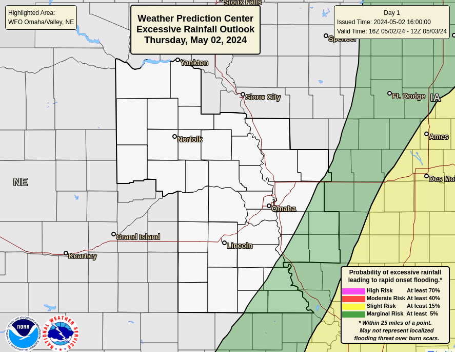 |
Day 2 Excessive Rain OAX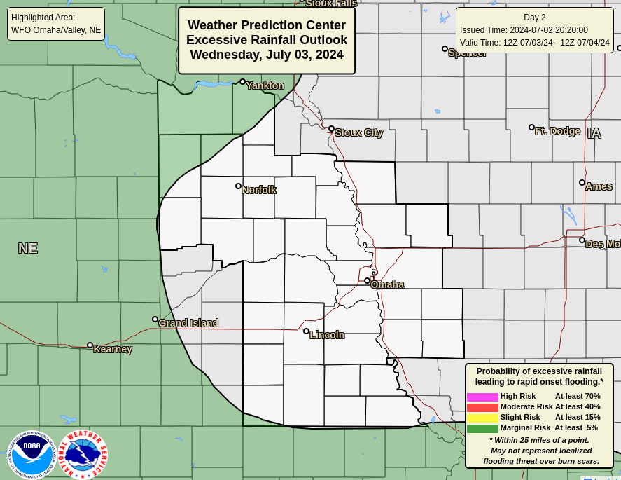 |
Day 3 Excessive Rain OAX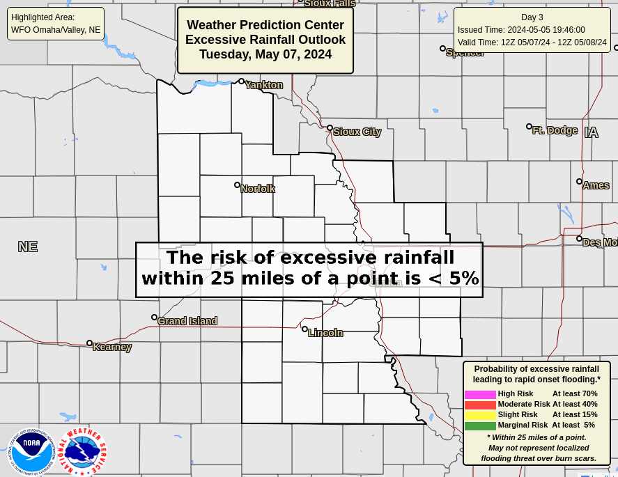 |
Day 1 Excessive Rain NE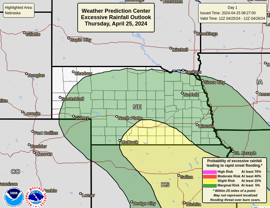 |
Day 2 Excessive Rain NE |
Day 3 Excessive Rain NE |
Day 1 Excessive Rain IA |
Day 2 Excessive Rain IA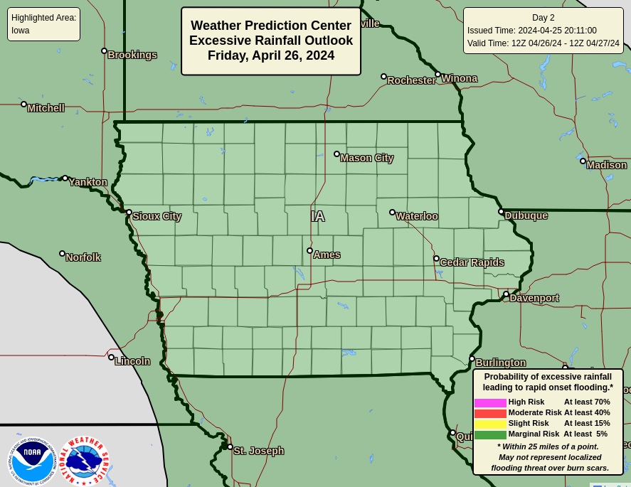 |
Day 3 Excessive Rain IA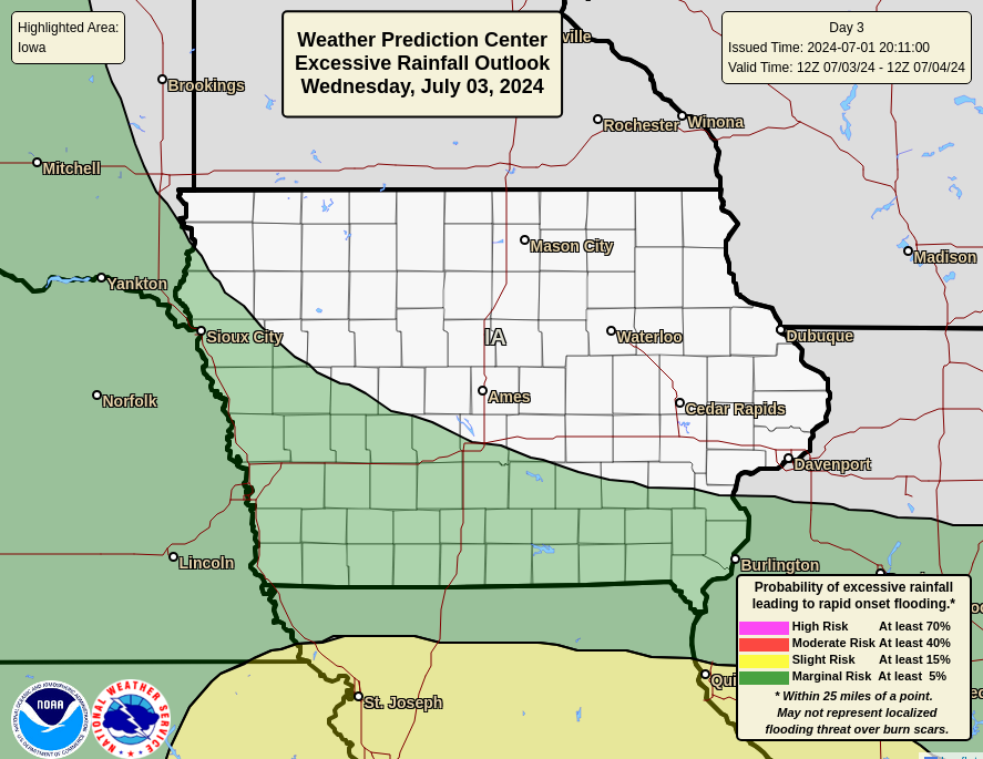 |
Day 1 Excessive Rain FEMA 7 |
Day 2 Excessive Rain FEMA 7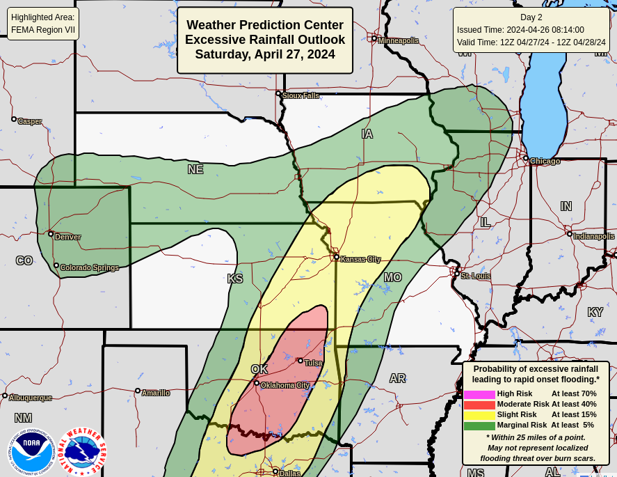 |
Day 3 Excessive Rain FEMA 7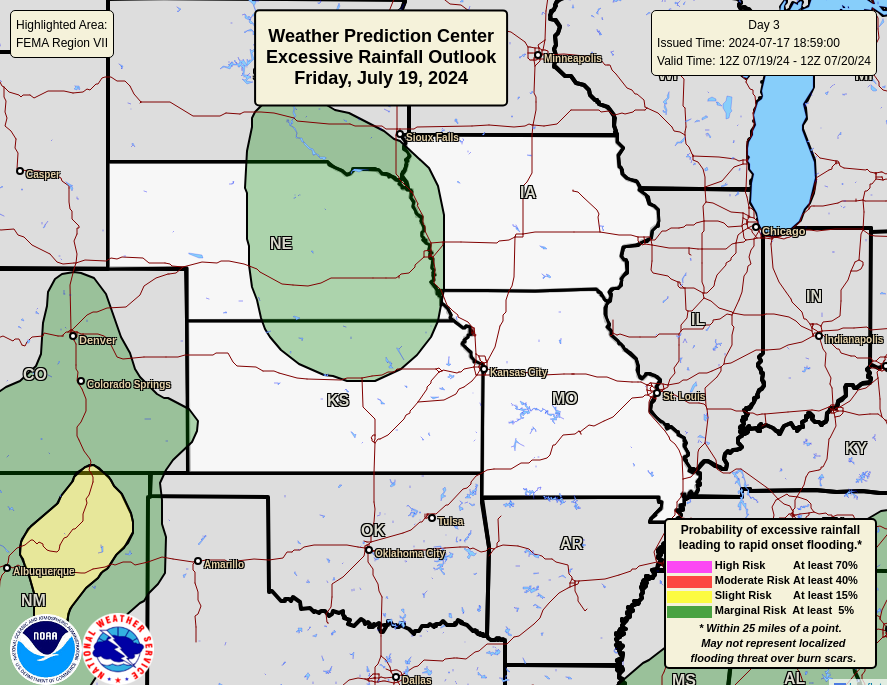 |
| Day 4/5 QPF | 5 Day Total QPF | Day 6/7 QPF |
 |
 |
 |
| 6-10 Day Temperature | 8-14 Day Temperature | 3-4 Week Temperature |
 |
 |
 |
| 6-10 Day Precipitation | 8-14 Day Precipitation | 3-4 Week Precipitation |
 |
 |
 |
| Mid Month Temp | End of Month Temp | Three Month Temperature |
 |
 |
 |
| Mid Month Precipitation | End of Month Precipitation | Three Month Precipitation |
 |
 |
 |
| All Temperature | All Precipitation | |
 |
 |
|
| Drought Monitor | OAX Drought | Drought Outlook |
 |
 |
 |
| Nebraska Drought | Iowa Drought | Precip Needed |
 |
 |
 |
 |
 |
| Day 1 Snow(>= 4 inches) | Day 2 Snow(>= 4 inches) | Day 3 Snow(>= 4 inches) |
 |
 |
 |
| Day 1 Snow(>= 8 inches) | Day 2 Snow(>= 8 inches) | Day 3 Snow(>= 8 inches) |
 |
 |
 |
| Day 1 Snow(>= 12 inches) | Day 2 Snow(>= 12 inches) | Day 3 Snow(>= 12 inches) |
 |
 |
 |
| Day 1 Probability Ice (>= 1/4 inch) | Day 2 Probability Ice (>= 1/4 inch) | Day 3 Probability Ice (>= 1/4 inch) |
 |
 |
 |
Day 4
 |
Day 5
 |
Day 6 Snow |
Day 7 Snow
 |
Overall WSSI for OAX - Winter Storm Severity Index - Archive
|
|||||||||||||||||||||||||||||||||
|
Day 1 Snow
 |
Day 2 Snow
 |
Day 3 Snow |
Day 4 Snow
 |
Day 1 Ice
 |
Day 2 Ice
 |
Day 3 Ice |
Day 4 Ice
 |


