Norman, OK
Weather Forecast Office

CoCoRaHS Is Here!
What IS CoCoRaHS?
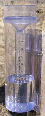
There is a new way to let the National Weather Service know how much rain, hail, or snow you've measured in your back yard! The Community Collaborative Rain, Hail, and Snow (CoCoRaHS) Network is here. CoCoRaHS is a unique, non-profit, community-based network of volunteers of all ages and backgrounds working together to measure and map precipitation (rain, hail and snow). The program will help meteorologists, hydrologists, and researchers study the variability of precipitation across Alabama, and the accumulated data will be available to anyone with a use or interest in precipitation data.
How did CoCoRaHS get started?
CoCoRaHS started because of a devastating flood that struck Fort Collins, Colorado in 1998. When researchers went back to examine the precipitation data, they discovered that the rainfall leading to the flood missed all of the official gages. Colorado State Climatologist Nolan Doeskin developed a new volunteer observing network to fill in the gaps between official gages called CoCoRaHS.
Sounds great! How can I sign up?
There are three options available, depending on where you live and the measuring equipment you have.
Current Hazards
Local
Nationwide
Local Storm Reports
Current Conditions
More Observations
Surface Maps
Upper Air Maps
Rivers and Lakes
Satellite Imagery
Forecasts
Submit a Spot Forecast
Graphical Forecasts
Air Quality
Forecast Discussion
Fire Weather
Winter Weather
Aviation Weather
Warnings and Other Products
Special Weather Statements
Flash Flood Warnings
Non Precipitation Warnings
Severe Thunderstorm Warnings
Winter Weather Warnings
Tornado Warnings
Flood Warnings
Climate and Past Weather
Averages and Records
Storm Data
Daily Weather History
Significant Weather Events
Local Climate Data
Tornado Database
US Dept of Commerce
National Oceanic and Atmospheric Administration
National Weather Service
Norman, OK
National Weather Center
120 David L. Boren Blvd. Suite 2400
Norman, OK 73072
(405) 325-3816
Comments? Questions? Please Contact Us.

