
A heat wave over the Southwest will intensify this week, peaking and expanding into the Intermountain West and northern High Plains this weekend. Critical to extremely critical fire weather conditions are forecast from the Northwest and the northern Great Basin this weekend. Particularly Dangerous Situation Red Flag Warnings have been issued. Read More >
Norman, OK
Weather Forecast Office
This is a collection of forecasts and forecast information for the area serviced by the National Weather Service Forecast Office in Norman, Oklahoma - western and central Oklahoma, and western north Texas. Everything has been divided up by the type of forecast.
 |
Text Forecasts 7-Day Forecast By County [ZFP] - a seven day forecast for each county. Point Forecast Matrix [PFM] - a tabular breakdown of the forecast for points. Area Forecast Matrix [AFM] - a tabular breakdown of the forecast for counties. Tabular State Forecast [SFT] - a summary of the forecast for selected cities. |
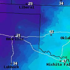 |
Digital/Graphical Forecasts Local Graphical Forecasts - a colorized, graphical image of the forecast. Southern Plains Graphical Forecasts - a regional graphical forecast. Activity Planner - Pick your location and the weather elements you care about for a customized forecast. |
Current Hazards
Local
Nationwide
Local Storm Reports
Current Conditions
More Observations
Surface Maps
Upper Air Maps
Rivers and Lakes
Satellite Imagery
Forecasts
Air Quality
Forecast Discussion
Fire Weather
Winter Weather
Aviation Weather
Submit a Spot Forecast
Graphical Forecasts
Warnings and Other Products
Non Precipitation Warnings
Severe Thunderstorm Warnings
Winter Weather Warnings
Tornado Warnings
Flood Warnings
Special Weather Statements
Flash Flood Warnings
Climate and Past Weather
Daily Weather History
Significant Weather Events
Local Climate Data
Tornado Database
Averages and Records
Storm Data
US Dept of Commerce
National Oceanic and Atmospheric Administration
National Weather Service
Norman, OK
National Weather Center
120 David L. Boren Blvd. Suite 2400
Norman, OK 73072
(405) 325-3816
Comments? Questions? Please Contact Us.

