
A heat wave over the Southwest will intensify this week, peaking and expanding into the Intermountain West and northern High Plains this weekend. Critical to extremely critical fire weather conditions are forecast from the Northwest and the northern Great Basin this weekend. Particularly Dangerous Situation Red Flag Warnings have been issued. Read More >
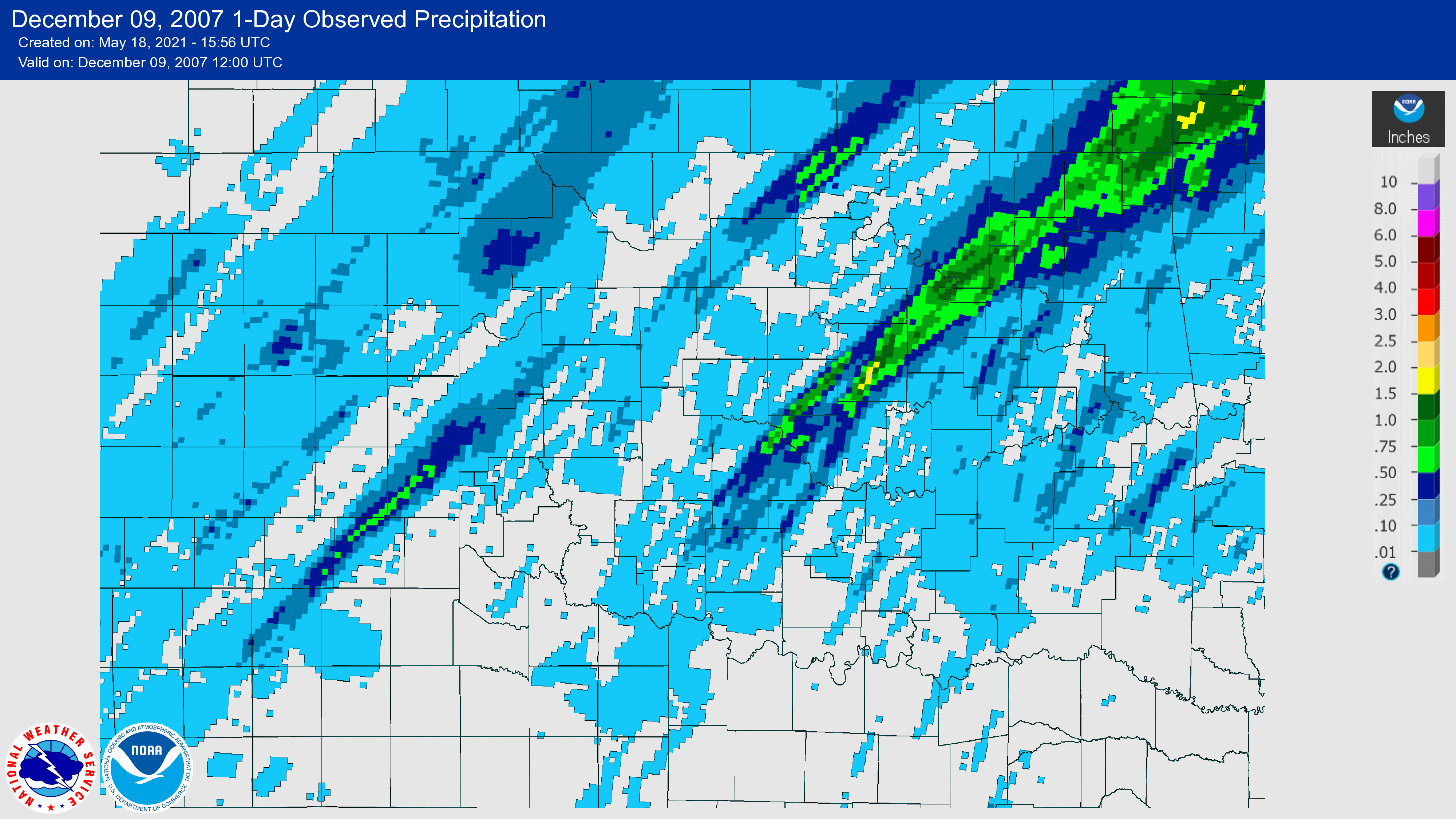
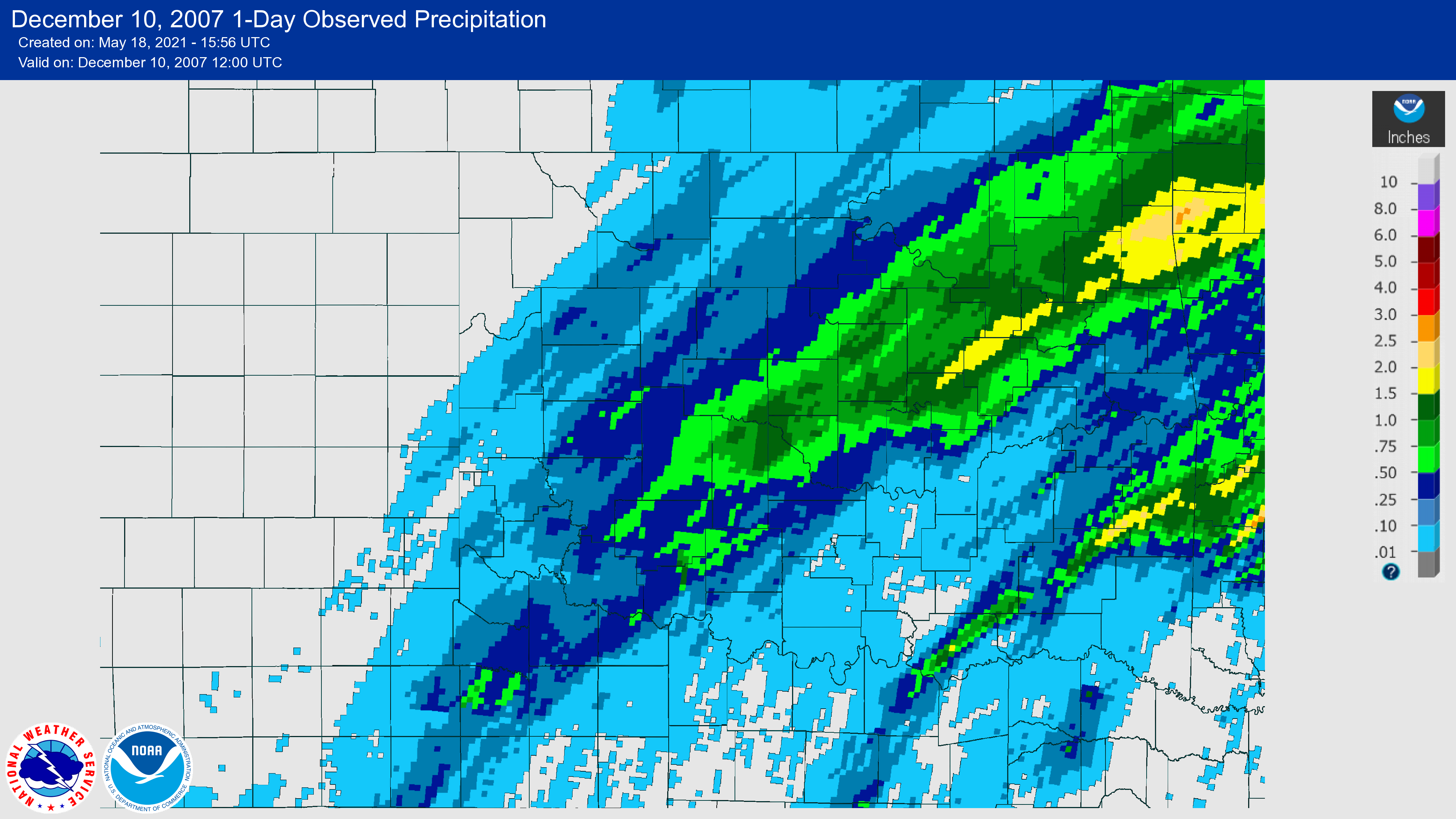
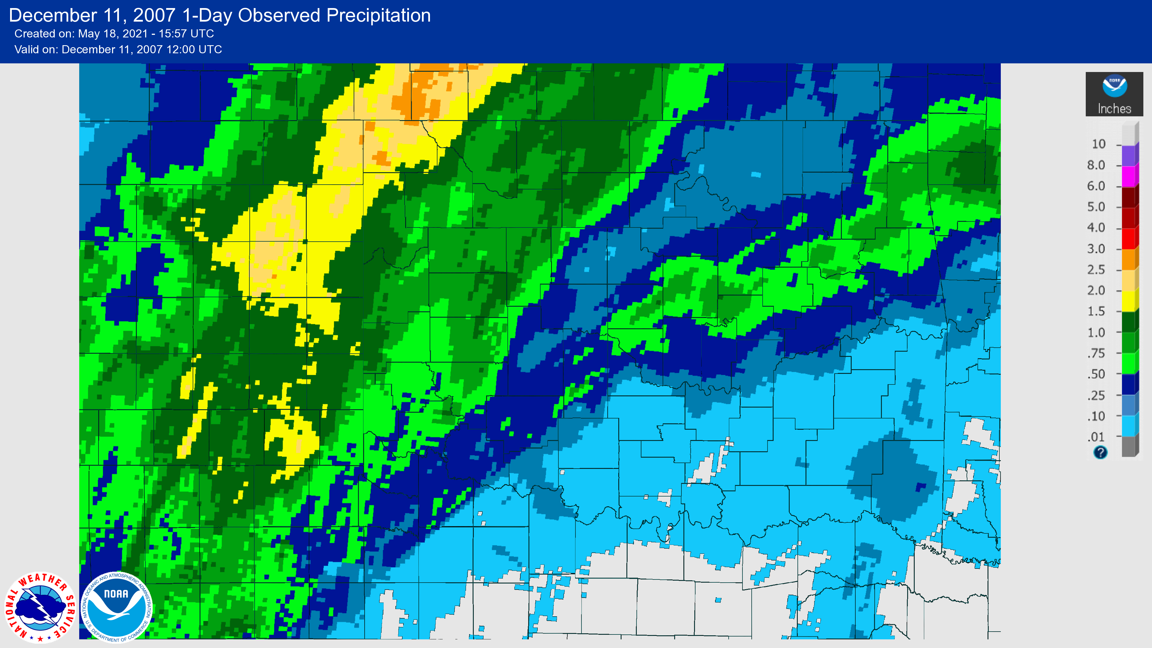
A devastating ice storm affected a large swath of Oklahoma beginning on December 9, 2007 and continuing through December 11, 2007 over parts of the NWS Norman forecast area. The storm left behind a trail of severe damage to trees and power lines, which in turn led to the worst power outage in Oklahoma history (in terms of the number of people impacted). This was because the worst of the ice storm affected the urban corridor from near Lawton, to Oklahoma City, to Tulsa, and northeast into Missouri.
The storm began with a strong cold front that moved through the northern half of Oklahoma on the December 8, 2007, and then moved south through the rest of the state during the day on the December 9th. South of the front, an almost tropical airmass was in place with temperatures in the 60s and 70s. Showers and thunderstorms were ongoing over central and southwest Oklahoma early on the 9th, but were developing and moving above a layer of freezing air at the surface.
However, as the cold front moved south, the cold air undercut the thunderstorms, which became the start of many waves of freezing showers and thunderstorms. The very moist airmass south of the front continued to move over top of the shallow cold airmass through December 11th. This classic setup created one of the costliest ice storms in Oklahoma history.
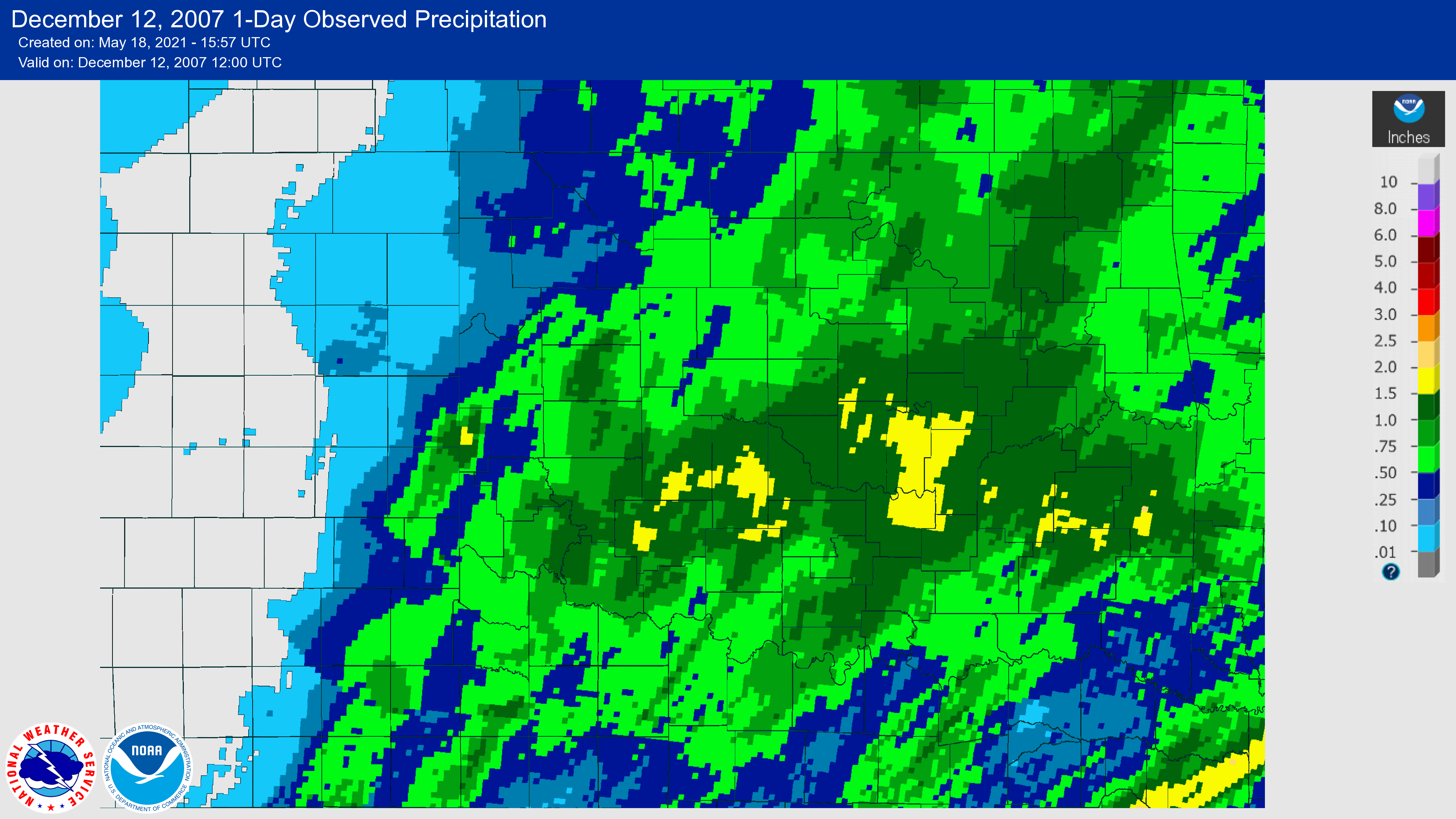
By the time the storm had ended, over one inch of ice had accumulated over a good portion of Oklahoma. The governor declared a State of Emergency for all 77 Oklahoma counties. At least 27 deaths were reported statewide, mainly due to hundreds of automobile accidents, although some were due to prolonged cold air exposure or carbon monoxide poisoning. Most of the December 12th morning flights in and out of Will Rogers World Airport were canceled because of icy runways.
Tree, power line and power pole damage was widespread statewide, which resulted in hundreds of thousands without power. Some of the trees that had to be cut back or cut down altogether were over 100 years old. At the peak of the event, more than 641,000 electric customers were without power (the actual number of people was likely much larger).
Due to the magnitude of the outage, electrical crews from dozens of states worked 12-hour shifts daily to restore power. Even with this huge relief effort, more than 150,000 residents were still without power one week later. Even city water and sewage plants were without power, making them unable to pump water for a short time.
Fallen power lines created another hazard as the broken lines sparked structure fires. Fire departments responded to over 100 structure fires in all. Other fires were caused by portable heating sources inside the home. Schools, churches, and local businesses had to close, some for several days due to the power outages. Christmas parades and area sporting events had to be rescheduled or canceled all together. Final exams at area colleges were also postponed.
The local economy took a huge hit as the ice storm hit during a key weekend for holiday sales. The pecan crop loss alone was estimated at $25 million statewide. Shelters were opened across the state for people who did not have electricity, which many took advantage of. The storm cleanup was estimated to cost at least $200 million statewide. Cities were expected to remove over 750,000 cubic yards of debris.
NWUS54 KOUN 091756
LSROUN

PRELIMINARY LOCAL STORM REPORT
NATIONAL WEATHER SERVICE NORMAN OK
1156 AM CST SUN DEC 09 2007

..TIME...   ...EVENT...      ...CITY LOCATION...     ...LAT.LON...
..DATE...   ....MAG....      ..COUNTY LOCATION..ST.. ...SOURCE....
            ..REMARKS..

0730 AM     ICE STORM        ENID                    36.40N 97.88W
12/09/2007                   GARFIELD           OK   EMERGENCY MNGR

            THE COUNTY EMERGENCY MANAGER REPORTED 0.25 INCHES OF ICE
            ACCUMULATION.

0815 AM     ICE STORM        KENDRICK                35.79N 96.77W
12/09/2007                   LINCOLN            OK   EMERGENCY MNGR

            THE COUNTY EMERGENCY MANAGER REPORTED 1/8 TO 1/4 INCHES
            OF ICE ACUMULATION JUST NORTHWEST OF KENDRICK.

1045 AM     ICE STORM        OKLAHOMA CITY           35.47N 97.51W
12/09/2007                   OKLAHOMA           OK   TRAINED SPOTTER

            A TRAINED SPOTTER REPORTED 1/3 OF AN INCH OF ICE
            ACCUMULATION AT HERITAGE PARK MALL AND RENO AVENUE
            BETWEEN AIR DEPOT AND SOONER ROAD. NUMEROUS BRANCHES WERE
            REPORTED DOWNED BY THE ICE.

0510 AM     ICE STORM        NORMAN                  35.22N 97.44W
12/09/2007                   CLEVELAND          OK   TRAINED SPOTTER

            SEVERAL LARGE LIMBS WERE DOWNED DUE TO THE ICE BUILDUP.


&&

$$

TY
NWUS54 KOUN 092116
LSROUN

PRELIMINARY LOCAL STORM REPORT
NATIONAL WEATHER SERVICE NORMAN OK
315 PM CST SUN DEC 09 2007

..TIME...   ...EVENT...      ...CITY LOCATION...     ...LAT.LON...
..DATE...   ....MAG....      ..COUNTY LOCATION..ST.. ...SOURCE....
            ..REMARKS..

0110 PM     ICE STORM        3 N PIEDMONT            35.69N 97.75W
12/09/2007                   CANADIAN           OK   CO-OP OBSERVER

            REPORTED 0.25 INCH THICK OF ICE ACCUMULATION

0245 PM     ICE STORM        WATONGA                 35.85N 98.41W
12/09/2007                   BLAINE             OK   LAW ENFORCEMENT

            REPORTED 0.50 INCH OF ICE ACCUMULATION ON GROUND

0215 PM     ICE STORM        SHAWNEE                 35.34N 96.92W
12/09/2007                   POTTAWATOMIE       OK   EMERGENCY MNGR

            REPORTED UP TO 0.25 INCHES OF ICE ACCUMULATION ON GROUND


&&

$$

JPIKE
NWUS54 KOUN 101628
LSROUN

PRELIMINARY LOCAL STORM REPORT
NATIONAL WEATHER SERVICE NORMAN OK
1023 AM CST MON DEC 10 2007

..TIME...   ...EVENT...      ...CITY LOCATION...     ...LAT.LON...
..DATE...   ....MAG....      ..COUNTY LOCATION..ST.. ...SOURCE....
            ..REMARKS..

0100 AM     ICE STORM        MIDWEST CITY            35.46N 97.37W
12/10/2007                   OKLAHOMA           OK   EMERGENCY MNGR

            HUNDREDS OF TREE LIMBS HAVE BEEN DOWNED BY THE HEAVY ICE
            ACCUMULATION. ONE TREE LIMB THROUGH A ROOF NEAR SE 20TH.


0400 AM     ICE STORM        BETHANY                 35.51N 97.64W
12/10/2007                   OKLAHOMA           OK   NWS EMPLOYEE

            A QUARTER TO A HALF OF AN INCH OF ICE HAS ACCUMULATED AT
            36TH AND COUNCIL ROAD.

0500 AM     ICE STORM        OKLAHOMA CITY           35.47N 97.51W
12/10/2007                   OKLAHOMA           OK   EMERGENCY MNGR

            WIDESPREAD TREE DAMAGE HAS OCCURRED OVER MUCH OF THE
            OKLAHOMA CITY AREA. NUMEROUS TREES AND TREE LIMBS HAVE
            FALLEN ON ROADWAYS WHICH HAS CAUSED MINOR TRAFFIC
            PROBLEMS. THOUSANDS OF RESIDENTS ARE WITHOUT POWER.

0600 AM     ICE STORM        WALTERS                 34.36N 98.31W
12/10/2007                   COTTON             OK   CO-OP OBSERVER

            A QUARTER OF AN INCH OF ICE HAS ACCUMULATED.

0600 AM     ICE STORM        NORMAN                  35.22N 97.44W
12/10/2007                   CLEVELAND          OK   NWS EMPLOYEE

            NUMEROUS TREES AND TREE LIMBS HAVE BEEN DOWNED DUE TO THE
            HEAVY ICE ACCUMULATIONS.

0600 AM     ICE STORM        SHAWNEE                 35.34N 96.92W
12/10/2007                   POTTAWATOMIE       OK   EMERGENCY MNGR

            A QUARTER OF AN INCH OF ICE HAS ACCUMULATED. NUMEROUS
            TREE LIMBS HAVE BEEN DOWNED AS A RESULT AND POWER OUTAGES
            HAVE BEEN INCREASING ALL MORNING.

0700 AM     ICE STORM        1 W BLANCHARD           35.15N 97.68W
12/10/2007                   GRADY              OK   NWS EMPLOYEE

            A QUARTER TO A HALF OF AN INCH OF ICE HAS ACCUMULATED.

0700 AM     ICE STORM        CANUTE                  35.43N 99.28W
12/10/2007                   WASHITA            OK   DEPT OF HIGHWAYS

            DOZENS OF TRAFFIC ACCIDENTS, INCLUDING SEVERAL SEMIS
            OVERTURNING, HAVE BEEN REPORTED DUE TO THE ICE
            ACCUMULATION ON INTERSTATE 40.

0800 AM     ICE STORM        3 N PIEDMONT            35.69N 97.75W
12/10/2007                   CANADIAN           OK   CO-OP OBSERVER

            THREE QUARTERS OF AN INCH OF ICE HAS ACCUMULATED ON THE
            GROUND.

1000 AM     ICE STORM        CARNEY                  35.81N 97.02W
12/10/2007                   LINCOLN            OK   BROADCAST MEDIA

            LOCAL BROADCAST MEDIA REPORTED WIDESPREAD TREE DAMAGE IN
            THE CARNEY AND WELLSTON AREAS.

1000 AM     ICE STORM        NORMAN                  35.22N 97.44W
12/10/2007                   CLEVELAND          OK   NWS EMPLOYEE

            NUMEROUS TREES, TREE LIMBS, AND POWER LINES HAVE BEEN
            DOWNED DUE TO THE ICE ACCUMULATION. THOUSANDS OF HOMES
            ARE WITHOUT POWER.


&&

$$

TY
| ID | Location | County | State | Source | Latitude | Longitude | Precipitation Total |
Snowfall Total |
|---|---|---|---|---|---|---|---|---|
| CHRO2 | Cherokee 4 W | Alfalfa | OK | COOP | 36.767 | -98.424 | 1.97 | T |
| GSDO2 | Great Salt Plains Dam | Alfalfa | OK | COOP | 36.743 | -98.133 | 2.33 | 0.5 |
| HELO2 | Helena 1 SSE | Alfalfa | OK | COOP | 36.538 | -98.266 | 2.23 | 1.2 |
| ATOO2 | Atoka | Atoka | OK | COOP | 34.398 | -96.140 | 1.40 | 0.0 |
| CANO2 | Caney 1 E | Atoka | OK | COOP | 34.230 | -96.195 | 1.68 | 0.0 |
| DAIO2 | Daisy 4 ENE | Atoka | OK | COOP | 34.544 | -95.676 | 2.57 | 0.0 |
| FRSO2 | Farris 3 WNW | Atoka | OK | GOES | 34.271 | -95.912 | 2.26 | |
| LNSO2 | Lane 1 WNW Mesonet | Atoka | OK | MESO | 34.309 | -95.997 | 1.94 | |
| MGDO2 | McGee Creek Dam | Atoka | OK | COOP | 34.310 | -95.867 | 2.43 | 0.0 |
| MGMO2 | McGee Creek Lake | Atoka | OK | GOES | 34.314 | -95.875 | 1.85 | |
| CARO2 | Carter 3 S | Beckham | OK | GOES | 35.168 | -99.507 | 1.25 | |
| ELCO2 | Elk City Weather Station | Beckham | OK | GOES | 35.393 | -99.506 | 1.61 | |
| ERIO2 | Erick | Beckham | OK | COOP | 35.216 | -99.863 | 1.85 | 0.6 |
| MRVO2 | Moravia 2 NNE | Beckham | OK | COOP | 35.146 | -99.496 | 1.42 | 0.0 |
| RETO2 | Retrop | Beckham | OK | COOP | 35.158 | -99.366 | 1.77 | 0.0 |
| SARO2 | Sayre | Beckham | OK | COOP | 35.306 | -99.627 | 1.42 | 0.2 |
| OK-BC-2 | Sayre 5.6 N | Beckham | OK | CoCoRaHS | 35.379 | -99.628 | 1.61 | 0.0 |
| OK-BL-1 | Geary 9.8 WNW | Blaine | OK | CoCoRaHS | 35.685 | -98.474 | 1.95 | 0.0 |
| OKNO2 | Okeene | Blaine | OK | COOP | 36.122 | -98.315 | 1.78 | 0.3 |
| WTNO2 | Watonga | Blaine | OK | COOP | 35.858 | -98.414 | 1.92 | T |
| JWG | Watonga Regional Airport | Blaine | OK | AWOS | 35.865 | -98.421 | 1.14 | |
| BLUO2 | Blue 1 W | Bryan | OK | GOES | 33.997 | -96.241 | 2.34 | |
| BOKO2 | Bokchito | Bryan | OK | COOP | 34.016 | -96.134 | 1.90 | 0.0 |
| DUAO2 | Durant | Bryan | OK | COOP | 34.000 | -96.369 | 1.59 | 0.0 |
| DTSO2 | Durant 6 SSE Mesonet | Bryan | OK | MESO | 33.921 | -96.320 | 2.90 | |
| DUA | Durant/Eaker Field | Bryan | OK | AWOS | 33.940 | -96.395 | 1.40 | |
| ANAO2 | Anadarko 3 E | Caddo | OK | COOP | 35.062 | -98.199 | 2.49 | 0.0 |
| APSO2 | Apache 4 ENE Mesonet | Caddo | OK | MESO | 34.914 | -98.292 | 2.14 | |
| CCWO2 | Cordell 9 E | Caddo | OK | GOES | 35.291 | -98.836 | 1.48 | |
| EAKO2 | Eakly 2 SW | Caddo | OK | GOES | 35.291 | -98.594 | 1.03 | |
| EASO2 | Fort Cobb Micronet Station F105 | Caddo | OK | MICRO | 35.407 | -98.571 | 1.29 | |
| EBSO2 | Fort Cobb Micronet Station F106 | Caddo | OK | MICRO | 35.392 | -98.514 | 1.32 | |
| ECSO2 | Fort Cobb Micronet Station F107 | Caddo | OK | MICRO | 35.376 | -98.465 | 1.21 | |
| EFSO2 | Fort Cobb Micronet Station F110 | Caddo | OK | MICRO | 35.330 | -98.520 | 1.34 | |
| LKSO2 | Fort Cobb Micronet Station F111 | Caddo | OK | MICRO | 35.334 | -98.438 | 1.04 | |
| AFSO2 | Fort Cobb Micronet Station F115 | Caddo | OK | MICRO | 35.229 | -98.606 | 1.54 | |
| COSO2 | Little Washita Micronet Station A13 | Caddo | OK | MICRO | 34.949 | -98.128 | 1.41 | |
| LKBO2 | Lookeba 1 N | Caddo | OK | COOP | 35.374 | -98.377 | 1.23 | T |
| OK-CN-2 | Mustang 2.1 WNW | Canadian | OK | CoCoRaHS | 35.404 | -97.757 | 2.15 | 0.0 |
| PIEO2 | Piedmont 3 N | Canadian | OK | COOP | 35.691 | -97.745 | 1.73 | 1.6 |
| OK-CN-7 | Piedmont 3.2 ESE | Canadian | OK | CoCoRaHS | 35.649 | -97.706 | 1.80 | 0.0 |
| UNCO2 | Union City 3 SE | Canadian | OK | COOP | 35.367 | -97.887 | 2.16 | T |
| ARMO2 | Ardmore | Carter | OK | COOP | 34.177 | -97.162 | 1.06 | 0.0 |
| ARSO2 | Ardmore 3 ENE Mesonet | Carter | OK | MESO | 34.192 | -97.086 | 1.23 | |
| LGSO2 | Ardmore 7 NNW Mesonet | Carter | OK | MESO | 34.228 | -97.201 | 1.35 | |
| 1F0 | Ardmore Downtown Executive Airp | Carter | OK | AWOS | 34.147 | -97.123 | 1.23 | |
| DURO2 | Dickson 3 N | Carter | OK | GOES | 34.233 | -96.976 | 1.45 | |
| HLDO2 | Healdton 3 E | Carter | OK | COOP | 34.233 | -97.420 | 1.17 | 0.0 |
| OK-CV-10 | Hall Park 2.7 S | Cleveland | OK | CoCoRaHS | 35.201 | -97.404 | 3.06 | 0.0 |
| OK-CV-3 | Hall Park 4.7 W | Cleveland | OK | CoCoRaHS | 35.240 | -97.490 | 2.67 | 0.0 |
| OK-CV-7 | Hall Park 5.3 W | Cleveland | OK | CoCoRaHS | 35.249 | -97.500 | 3.41 | 0.0 |
| OK-CV-43 | Moore 0.5 NE | Cleveland | OK | CoCoRaHS | 35.335 | -97.470 | 3.61 | 0.0 |
| OK-CV-39 | Newcastle 5.1 ESE | Cleveland | OK | CoCoRaHS | 35.220 | -97.516 | 2.86 | 0.0 |
| OK-CV-16 | Noble 1.5 WNW | Cleveland | OK | CoCoRaHS | 35.150 | -97.396 | 3.07 | 0.0 |
| OK-CV-20 | Noble 1.7 E | Cleveland | OK | CoCoRaHS | 35.222 | -97.409 | 3.91 | 0.0 |
| OK-CV-13 | Noble 3.1 NNW | Cleveland | OK | CoCoRaHS | 35.178 | -97.402 | 2.87 | 0.0 |
| OK-CV-21 | Noble 3.7 NW | Cleveland | OK | CoCoRaHS | 35.172 | -97.426 | 3.35 | 0.0 |
| NRSO2 | Norman 2 NW Mesonet | Cleveland | OK | MESO | 35.236 | -97.465 | 2.98 | |
| OK-CV-32 | Norman 2.1 SE | Cleveland | OK | CoCoRaHS | 35.198 | -97.418 | 3.33 | 0.0 |
| OK-CV-2 | Norman 2.4 NNE | Cleveland | OK | CoCoRaHS | 35.256 | -97.428 | 3.24 | 0.0 |
| OK-CV-45 | Norman 2.7 SW | Cleveland | OK | CoCoRaHS | 35.194 | -97.471 | 3.05 | 0.0 |
| NMNO2 | Norman 3 SSE | Cleveland | OK | COOP | 35.181 | -97.438 | 2.68 | T |
| OK-CV-12 | Norman 3.1 WNW | Cleveland | OK | CoCoRaHS | 35.239 | -97.490 | 3.36 | 0.0 |
| OK-CV-47 | Norman 3.5 E | Cleveland | OK | CoCoRaHS | 35.213 | -97.378 | 2.79 | 0.0 |
| OK-CV-46 | Norman 4.8 ESE | Cleveland | OK | CoCoRaHS | 35.195 | -97.360 | 3.29 | 0.0 |
| OK-CV-29 | Norman 6.3 E | Cleveland | OK | CoCoRaHS | 35.222 | -97.327 | 3.23 | 0.0 |
| OK-CV-24 | Norman 6.5 SE | Cleveland | OK | CoCoRaHS | 35.178 | -97.338 | 2.71 | 0.0 |
| OK-CV-6 | Norman 7.9 ESE | Cleveland | OK | CoCoRaHS | 35.208 | -97.300 | 2.76 | 0.0 |
| OK-CV-9 | Norman 8.4 SE | Cleveland | OK | CoCoRaHS | 35.193 | -97.295 | 2.72 | 0.0 |
| OK-CV-34 | Norman 9.2 E | Cleveland | OK | CoCoRaHS | 35.229 | -97.277 | 2.48 | 0.0 |
| OUN | Norman/Max Westheimer Airport | Cleveland | OK | AWOS | 35.246 | -97.472 | 2.50 | |
| CNSO2 | Centrahoma 1 E Mesonet | Coal | OK | MESO | 34.609 | -96.333 | 1.67 | |
| CENO2 | Centrahoma 2 ESE | Coal | OK | COOP | 34.601 | -96.313 | 1.88 | 0.0 |
| LEHO2 | Lehigh 4 SW | Coal | OK | COOP | 34.434 | -96.272 | 1.73 | 0.0 |
| CHAO2 | Chattanooga | Comanche | OK | COOP | 34.421 | -98.648 | 2.13 | 0.0 |
| FSI | Fort Sill/Henry Post Army Airfield | Comanche | OK | AWOS | 34.650 | -98.402 | 2.22 | |
| LWTO2 | Lawton | Comanche | OK | COOP | 34.610 | -98.457 | 3.06 | 0.0 |
| LAW | Lawton/Fort Sill Regional Airport | Comanche | OK | ASOS | 34.558 | -98.417 | 2.42 | |
| SOSO2 | Little Washita Micronet Station A16 | Comanche | OK | MICRO | 34.808 | -98.141 | 1.86 | |
| WMWO2 | Wichita Mountain WLR | Comanche | OK | COOP | 34.733 | -98.712 | 3.46 | T |
| DCNO2 | Duncan 10 W | Cotton | OK | COOP | 34.493 | -98.142 | 2.58 | 0.0 |
| RANO2 | Randlett 9 E | Cotton | OK | COOP | 34.158 | -98.311 | 1.19 | 0.0 |
| WALO2 | Walters | Cotton | OK | COOP | 34.360 | -98.301 | 2.70 | 0.0 |
| WTSO2 | Walters 1 NW Mesonet | Cotton | OK | MESO | 34.365 | -98.32 | 2.26 | |
| BTSO2 | Butler 5 SW Mesonet | Custer | OK | MESO | 35.591 | -99.271 | 1.46 | |
| CLK | Clinton Regional Airport | Custer | OK | AWOS | 35.538 | -98.933 | 1.31 | |
| HMMO2 | Hammon 4 ENE | Custer | OK | GOES | 35.656 | -99.306 | 1.42 | |
| WEAO2 | Weatherford | Custer | OK | COOP | 35.520 | -98.699 | 1.57 | 0.0 |
| OJA | Weatherford/Thomas P Stafford Airport | Custer | OK | AWOS | 35.546 | -98.669 | 1.16 | |
| CMSO2 | Camargo 4 WNW Mesonet | Dewey | OK | MESO | 36.029 | -99.346 | 1.31 | |
| LEEO2 | Leedey | Dewey | OK | COOP | 35.863 | -99.343 | 1.86 | 0.0 |
| PMSO2 | Putnam 3 N Mesonet | Dewey | OK | MESO | 35.899 | -98.960 | 1.30 | |
| TLGO2 | Taloga | Dewey | OK | COOP | 36.041 | -98.962 | 2.13 | 2.0 |
| GAG | Gage Airport | Ellis | OK | ASOS | 36.297 | -99.769 | 1.35 | |
| OK-GD-5 | Covington 1.8 N | Garfield | OK | CoCoRaHS | 36.333 | -97.586 | 1.41 | 0.0 |
| ENIO2 | Enid | Garfield | OK | COOP | 36.419 | -97.875 | 1.84 | 0.4 |
| END | Vance Air Force Base | Garfield | OK | AWOS | 36.339 | -97.917 | 1.62 | |
| SFSO2 | Byars 3 ESE Mesonet | Garvin | OK | MESO | 34.850 | -97.003 | 1.58 | |
| ELMO2 | Elmore City 3 SW | Garvin | OK | COOP | 34.610 | -97.422 | 1.36 | T |
| HENO2 | Hennepin 5 N | Garvin | OK | COOP | 34.580 | -97.351 | 1.15 | 0.0 |
| LINO2 | Lindsay 2 W | Garvin | OK | COOP | 34.826 | -97.639 | 2.00 | 0.0 |
| PVSO2 | Pauls Valley 1 SSW Mesonet | Garvin | OK | MESO | 34.716 | -97.229 | 1.35 | |
| PAUO2 | Pauls Valley 2 WNW | Garvin | OK | COOP | 34.725 | -97.281 | 2.00 | 0.0 |
| PVS | Pauls Valley Municipal Airport | Garvin | OK | AWOS | 34.711 | -97.223 | 1.14 | |
| ALXO2 | Alex 1 N | Grady | OK | GOES | 34.926 | -97.774 | 2.48 | |
| OK-GY-1 | Blanchard 1.8 SW | Grady | OK | CoCoRaHS | 35.129 | -97.683 | 2.83 | 0.0 |
| OK-GY-3 | Chickasha 1.8 SSE | Grady | OK | CoCoRaHS | 35.015 | -97.943 | 2.93 | 0.0 |
| CHKO2 | Chickasha Exp. Station | Grady | OK | COOP | 35.049 | -97.916 | 2.56 | 0.0 |
| COXO2 | Cox City 2 NE | Grady | OK | COOP | 34.742 | -97.704 | 1.84 | 0.6 |
| NHSO2 | Little Washita Micronet Station A12 | Grady | OK | MICRO | 34.959 | -97.899 | 1.91 | |
| NISO2 | Little Washita Micronet Station A13 | Grady | OK | MICRO | 34.927 | -98.020 | 2.22 | |
| AGSO2 | Little Washita Micronet Station A14 | Grady | OK | MICRO | 34.879 | -97.917 | 2.53 | |
| AMSO2 | Little Washita Micronet Station A14 | Grady | OK | MICRO | 34.885 | -98.023 | 1.82 | |
| AASO2 | Little Washita Micronet Station A15 | Grady | OK | MICRO | 34.843 | -97.958 | 2.19 | |
| RGSO2 | Little Washita Micronet Station A18 | Grady | OK | MICRO | 34.845 | -98.073 | 2.38 | |
| LWAO2 | Little Washita SCAN Site | Grady | OK | SCAN | 34.950 | -97.980 | 2.10 | |
| ACSO2 | Rush Springs 4 WNW Mesonet | Grady | OK | MESO | 34.808 | -98.023 | 1.80 | |
| OK-GT-1 | Hunter 6.0 NNE | Grant | OK | CoCoRaHS | 36.636 | -97.604 | 1.77 | 1.2 |
| JEFO2 | Jefferson 3 SE | Grant | OK | COOP | 36.686 | -97.749 | 1.51 | 0.0 |
| LAMO2 | Lamont | Grant | OK | COOP | 36.688 | -97.557 | 1.82 | T |
| MEDO2 | Medford | Grant | OK | COOP | 36.796 | -97.736 | 1.51 | 0.7 |
| MFSO2 | Medford 1 SW Mesonet | Grant | OK | MESO | 36.792 | -97.746 | 1.36 | |
| OK-GR-1 | Granite 0.6 WSW | Greer | OK | CoCoRaHS | 34.959 | -99.389 | 0.84 | 0.0 |
| GNTO2 | Granite 5 S | Greer | OK | GOES | 34.889 | -99.378 | 1.05 | |
| MGUO2 | Mangum | Greer | OK | COOP | 34.891 | -99.502 | 1.43 | 0.0 |
| MNSO2 | Mangum 5 SE Mesonet | Greer | OK | MESO | 34.836 | -99.424 | 1.08 | |
| WILO2 | Willow | Greer | OK | COOP | 35.052 | -99.512 | 1.43 | 0.0 |
| HOSO2 | Hollis 5 E | Harmon | OK | COOP | 34.681 | -99.813 | 1.77 | 0.2 |
| VINO2 | Vinson | Harmon | OK | COOP | 34.900 | -99.861 | 2.00 | T |
| BFSO2 | Buffalo 1 SW Mesonet | Harper | OK | MESO | 36.831 | -99.641 | 2.10 | |
| BFLO2 | Buffalo 2 SSW | Harper | OK | COOP | 36.800 | -99.640 | 2.42 | 1.0 |
| LAVO2 | Laverne | Harper | OK | COOP | 36.699 | -99.897 | 3.41 | 1.2 |
| HDNO2 | Holdenville 2 SSW | Hughes | OK | COOP | 35.057 | -96.386 | 2.37 | 0.0 |
| HLSO2 | Holdenville 7 SSE Mesonet | Hughes | OK | MESO | 34.992 | -96.334 | 2.25 | |
| WETO2 | Wetumka 3 NE | Hughes | OK | GOES | 35.266 | -96.206 | 2.27 | |
| ALSO2 | Altus 3 S Mesonet | Jackson | OK | MESO | 34.587 | -99.338 | 1.70 | |
| LTS | Altus Air Force Base | Jackson | OK | AWOS | 34.667 | -99.267 | 1.45 | |
| ALGO2 | Altus Irig Res. Station | Jackson | OK | COOP | 34.590 | -99.334 | 2.27 | 0.0 |
| AXS | Altus/Quartz Mountain Regional Airport | Jackson | OK | AWOS | 34.699 | -99.338 | 1.49 | |
| HEDO2 | Headrick | Jackson | OK | COOP | 34.629 | -99.139 | 2.29 | 0.0 |
| HEAO2 | Headrick 3 E | Jackson | OK | GOES | 34.638 | -99.103 | 1.75 | |
| GRDO2 | Grady 2 E | Jefferson | OK | COOP | 34.023 | -97.634 | 1.20 | 0.0 |
| RNSO2 | Ringling 1 N Mesonet | Jefferson | OK | MESO | 34.194 | -97.588 | 0.99 | |
| WKAO2 | Waurika | Jefferson | OK | COOP | 34.175 | -97.996 | 0.98 | 0.0 |
| WRSO2 | Waurika 1 E Mesonet | Jefferson | OK | MESO | 34.168 | -97.988 | 1.09 | |
| WRLO2 | Waurika Lake | Jefferson | OK | GOES | 34.233 | -98.048 | 0.79 | |
| COLO2 | Coleman 4 W | Johnston | OK | COOP | 34.276 | -96.495 | 1.55 | 0.0 |
| MCKO2 | Mill Creek 2 W | Johnston | OK | GOES | 34.405 | -96.863 | 1.61 | |
| MCPO2 | Mill Creek 4 ENE | Johnston | OK | GOES | 34.420 | -96.759 | 1.62 | |
| PONO2 | Pontotoc 1 N | Johnston | OK | COOP | 34.505 | -96.622 | 1.32 | 0.0 |
| TSSO2 | Tishomingo 6 N Mesonet | Johnston | OK | MESO | 34.333 | -96.679 | 1.20 | |
| TISO2 | Tishomingo Natl. WLR | Johnston | OK | COOP | 34.207 | -96.642 | 1.61 | 0.0 |
| BLKO2 | Blackwell 1 NE | Kay | OK | GOES | 36.811 | -97.277 | 1.84 | |
| BLAO2 | Blackwell 1 SSW | Kay | OK | COOP | 36.784 | -97.290 | 2.09 | 4.0 |
| BRMO2 | Braman | Kay | OK | COOP | 36.922 | -97.336 | 2.33 | 1.5 |
| HARO2 | Hardy 2 S | Kay | OK | GOES | 36.946 | -96.799 | 0.95 | |
| HRDO2 | Hardy 2 SSW | Kay | OK | COOP | 36.938 | -96.821 | 0.81 | 0.0 |
| NWKO2 | Newkirk 5 NE | Kay | OK | COOP | 36.942 | -97.006 | 1.50 | 0.0 |
| NKSO2 | Newkirk 8 E Mesonet | Kay | OK | MESO | 36.898 | -96.910 | 1.13 | |
| PNC | Ponca City Municipal Airport | Kay | OK | ASOS | 36.737 | -97.102 | 1.11 | |
| HSYO2 | Hennessey 4 ESE | Kingfisher | OK | COOP | 36.094 | -97.835 | 1.50 | 0.0 |
| KINO2 | Kingfisher | Kingfisher | OK | COOP | 35.858 | -97.929 | 1.70 | 0.0 |
| ATUO2 | Altus Dam | Kiowa | OK | COOP | 34.885 | -99.296 | 2.14 | 0.0 |
| ALTO2 | Altus-Lugert Lake | Kiowa | OK | GOES | 34.886 | -99.296 | 1.67 | |
| HBR | Hobart Municipal Airport | Kiowa | OK | ASOS | 34.989 | -99.052 | 1.25 | |
| RSVO2 | Roosevelt | Kiowa | OK | COOP | 34.851 | -99.021 | 2.04 | 0.0 |
| MTVO2 | Sedan | Kiowa | OK | COOP | 34.969 | -98.760 | 1.97 | 0.0 |
| CHNO2 | Chandler | Lincoln | OK | COOP | 35.706 | -96.880 | 1.10 | 0.0 |
| CHSO2 | Chandler 5 SE Mesonet | Lincoln | OK | MESO | 35.653 | -96.804 | 2.40 | |
| MKRO2 | Meeker 5 W | Lincoln | OK | COOP | 35.505 | -96.977 | 0.98 | 0.0 |
| PRGO2 | Prague 2 W | Lincoln | OK | COOP | 35.488 | -96.730 | 3.09 | 0.0 |
| STRO2 | Stroud 3 N | Lincoln | OK | COOP | 35.798 | -96.666 | 3.59 | T |
| CREO2 | Crescent 5 WSW | Logan | OK | COOP | 35.927 | -97.674 | 1.69 | 0.4 |
| OK-LG-3 | Edmond 4.3 NNE | Logan | OK | CoCoRaHS | 35.728 | -97.381 | 2.05 | 0.0 |
| OK-LG-2 | Guthrie 1.9 S | Logan | OK | CoCoRaHS | 35.813 | -97.430 | 1.97 | 0.0 |
| OK-LG-6 | Guthrie 3.7 NNW | Logan | OK | CoCoRaHS | 35.893 | -97.442 | 1.59 | 0.0 |
| GTSO2 | Guthrie 4 WSW Mesonet | Logan | OK | MESO | 35.849 | -97.480 | 1.54 | |
| OK-LG-4 | Guthrie 4.9 SSE | Logan | OK | CoCoRaHS | 35.771 | -97.409 | 2.08 | 0.0 |
| GUTO2 | Guthrie 5 S | Logan | OK | COOP | 35.816 | -97.395 | 1.80 | T |
| MSHO2 | Marshall | Logan | OK | COOP | 36.152 | -97.623 | 1.05 | 0.0 |
| MULO2 | Mulhall 1 SE | Logan | OK | COOP | 36.048 | -97.390 | 1.38 | T |
| BNSO2 | Burneyville 2 SE Mesonet | Love | OK | MESO | 33.894 | -97.269 | 1.26 | |
| MRTO2 | Marietta 5 SW | Love | OK | COOP | 33.876 | -97.164 | 1.44 | 0.0 |
| FVSO2 | Fairview 1 W Mesonet | Major | OK | MESO | 36.263 | -98.497 | 1.44 | |
| LAHO2 | Lahoma Research Station | Major | OK | COOP | 36.390 | -98.106 | 2.17 | 0.0 |
| ORIO2 | Orienta 1 SSW | Major | OK | COOP | 36.349 | -98.481 | 1.84 | 0.0 |
| SEIO2 | Seiling 3 N | Major | OK | GOES | 36.183 | -98.921 | 1.87 | |
| KNGO2 | Kingston 5 SSE | Marshall | OK | COOP | 33.930 | -96.696 | 1.29 | 0.0 |
| MADO2 | Madill | Marshall | OK | COOP | 34.092 | -96.771 | 1.49 | 0.0 |
| MDSO2 | Madill 11 WSW Mesonet | Marshall | OK | MESO | 34.036 | -96.943 | 1.55 | |
| BLNO2 | Blanchard 2 SSW | McClain | OK | COOP | 35.118 | -97.670 | 3.84 | 3.5 |
| OK-MC-2 | Blanchard 2.1 ESE | McClain | OK | CoCoRaHS | 35.133 | -97.624 | 3.51 | 0.0 |
| OK-MC-1 | Wayne 3.5 E | McClain | OK | CoCoRaHS | 34.911 | -97.254 | 2.57 | 0.0 |
| SULO2 | Chickasaw NRA | Murray | OK | COOP | 34.497 | -96.971 | 1.72 | 0.0 |
| DVSO2 | Davis 5 SSW | Murray | OK | GOES | 34.432 | -97.147 | 1.05 | |
| OK-MR-1 | Sulphur 2.5 WSW | Murray | OK | CoCoRaHS | 34.491 | -97.018 | 1.34 | 0.0 |
| SLSO2 | Sulphur 4 NNE Mesonet | Murray | OK | MESO | 34.566 | -96.950 | 1.64 | |
| BILO2 | Billings | Noble | OK | COOP | 36.530 | -97.447 | 1.40 | 0.4 |
| OK-NB-1 | Billings 4.1 SSE | Noble | OK | CoCoRaHS | 36.475 | -97.422 | 1.49 | 0.0 |
| OK-NB-4 | Garber 7.9 ESE | Noble | OK | CoCoRaHS | 36.375 | -97.460 | 1.68 | 3.0 |
| OK-NB-2 | Lucien 6.6 N | Noble | OK | CoCoRaHS | 36.375 | -97.443 | 0.86 | 0.0 |
| PRRO2 | Perry | Noble | OK | COOP | 36.289 | -97.290 | 1.61 | 0.0 |
| RDRO2 | Red Rock | Noble | OK | COOP | 36.461 | -97.180 | 0.70 | 0.0 |
| PYSO2 | Red Rock 7 SSE Mesonet | Noble | OK | MESO | 36.356 | -97.153 | 1.04 | |
| OK-OK-5 | Bethany 0.7 SSW | Oklahoma | OK | CoCoRaHS | 35.496 | -97.647 | 2.55 | 0.0 |
| OK-OK-1 | Bethany 0.8 W | Oklahoma | OK | CoCoRaHS | 35.508 | -97.657 | 2.63 | 0.0 |
| OK-OK-3 | Edmond 1.6 W | Oklahoma | OK | CoCoRaHS | 35.673 | -97.441 | 2.28 | 0.0 |
| OK-OK-15 | Edmond 6.1 WSW | Oklahoma | OK | CoCoRaHS | 35.641 | -97.515 | 1.47 | 0.0 |
| OK-OK-14 | Edmond 8.6 W | Oklahoma | OK | CoCoRaHS | 35.657 | -97.564 | 1.83 | 0.0 |
| OKC | OKC/Will Rogers World Airport | Oklahoma | OK | ASOS | 35.389 | -97.601 | 3.19 | T |
| OESO2 | Oklahoma City 3 ENE Mesonet | Oklahoma | OK | MESO | 35.472 | -97.464 | 2.02 | |
| OKCO2 | Oklahoma City 6 SW | Oklahoma | OK | COOP | 35.406 | -97.597 | 2.99 | 0.1 |
| OCSO2 | Oklahoma City 7 N Mesonet | Oklahoma | OK | MESO | 35.556 | -97.511 | 1.22 | |
| TIK | Tinker Air Force Base | Oklahoma | OK | AWOS | 35.415 | -97.387 | 2.38 | |
| OK-OK-13 | Wiley Post 1.6 NNW | Oklahoma | OK | CoCoRaHS | 35.553 | -97.657 | 2.52 | 0.0 |
| MASO2 | Coyle 7 N Mesonet | Payne | OK | MESO | 36.064 | -97.213 | 1.24 | |
| CUH | Cushing Municipal Airport | Payne | OK | AWOS | 35.950 | -96.773 | 1.46 | |
| INGO2 | Ingalls 1 N | Payne | OK | COOP | 36.114 | -96.879 | 1.24 | 0.0 |
| STWO2 | Stillwater 2 W | Payne | OK | COOP | 36.118 | -97.095 | 1.50 | T |
| SAFO2 | Stillwater 2 W CRN Site | Payne | OK | CRN | 36.118 | -97.091 | 1.45 | |
| SEFO2 | Stillwater 5 WNW CRN Site | Payne | OK | CRN | 36.134 | -97.108 | 1.50 | |
| ADAO2 | Ada | Pontotoc | OK | COOP | 34.786 | -96.685 | 2.13 | 0.0 |
| ADSO2 | Ada 2 NNE Mesonet | Pontotoc | OK | MESO | 34.799 | -96.669 | 2.35 | |
| FTBO2 | Fittstown | Pontotoc | OK | GOES | 34.60000 | -96.60000 | 2.41 | |
| FITO2 | Fittstown 2 E | Pontotoc | OK | GOES | 34.600 | -96.667 | 1.55 | |
| FISO2 | Fittstown 6 SW Mesonet | Pontotoc | OK | MESO | 34.552 | -96.718 | 1.61 | |
| VASO2 | Vanoss 2 NE Mesonet | Pontotoc | OK | MESO | 34.791 | -96.844 | 2.00 | |
| OK-PN-3 | Vanoss 4.5 E | Pontotoc | OK | CoCoRaHS | 34.758 | -96.792 | 2.55 | 0.0 |
| SHAO2 | Shawnee | Pottawatomie | OK | COOP | 35.355 | -96.920 | 3.55 | 0.0 |
| OK-PT-1 | Shawnee 0.8 ESE | Pottawatomie | OK | CoCoRaHS | 35.361 | -96.955 | 3.42 | 0.0 |
| SHSO2 | Shawnee 3 NNW Mesonet | Pottawatomie | OK | MESO | 35.365 | -96.948 | 2.22 | |
| SHLO2 | Shawnee Lake | Pottawatomie | OK | GOES | 35.347 | -97.063 | 2.28 | |
| SNL | Shawnee Municipal Airport | Pottawatomie | OK | AWOS | 35.357 | -96.943 | 2.19 | |
| OK-PT-2 | Tecumseh 0.4 ESE | Pottawatomie | OK | CoCoRaHS | 35.261 | -96.927 | 3.12 | 0.0 |
| CHYO2 | Cheyenne 1 N | Roger Mills | OK | GOES | 35.627 | -99.669 | 1.37 | |
| OK-RM-2 | Cheyenne 18.1 SW | Roger Mills | OK | CoCoRaHS | 35.861 | -99.782 | 1.40 | 0.0 |
| OK-RM-3 | Cheyenne 5.5 SSE | Roger Mills | OK | CoCoRaHS | 35.535 | -99.651 | 1.85 | 0.0 |
| CRWO2 | Cheyenne RAWS | Roger Mills | OK | RAWS | 35.708 | -99.905 | 1.15 | |
| KONO2 | Konawa | Seminole | OK | COOP | 34.961 | -96.750 | 1.05 | 0.0 |
| KCRO2 | Konowa 4 ESE | Seminole | OK | GOES | 34.933 | -96.683 | 1.77 | |
| SEMO2 | Seminole | Seminole | OK | COOP | 35.232 | -96.653 | 3.80 | 0.0 |
| SMSO2 | Seminole 4 SE Mesonet | Seminole | OK | MESO | 35.172 | -96.631 | 2.64 | |
| SRE | Seminole Municipal Airport | Seminole | OK | AWOS | 35.275 | -96.675 | 2.38 | |
| WEWO2 | Wewoka 3 SW | Seminole | OK | COOP | 35.131 | -96.539 | 2.95 | 0.0 |
| CMNO2 | Comanche | Stephens | OK | COOP | 34.362 | -97.974 | 1.54 | 0.0 |
| DNCO2 | Duncan | Stephens | OK | COOP | 34.501 | -97.959 | 2.16 | 0.0 |
| DUC | Duncan/ Halliburton Field Airport | Stephens | OK | AWOS | 34.471 | -97.960 | 1.75 | |
| LOCO2 | Loco | Stephens | OK | COOP | 34.328 | -97.679 | 0.80 | 0.0 |
| MLWO2 | Marlow 1 WSW | Stephens | OK | COOP | 34.637 | -97.979 | 2.11 | 0.0 |
| DNSO2 | Velma 7 NW Mesonet | Stephens | OK | MESO | 34.529 | -97.765 | 1.21 | |
| FRDO2 | Frederick | Tillman | OK | COOP | 34.386 | -99.020 | 1.61 | 0.0 |
| FDR | Frederick Municipal Airport | Tillman | OK | ASOS | 34.210 | -98.590 | 1.70 | |
| GRSO2 | Grandfield 3 W Mesonet | Tillman | OK | MESO | 34.239 | -98.744 | 1.18 | |
| TPSO2 | Tipton 4 S Mesonet | Tillman | OK | MESO | 34.440 | -99.137 | 1.54 | |
| BSSO2 | Bessie 4 WNW Mesonet | Washita | OK | MESO | 35.402 | -99.058 | 1.38 | |
| CSM | Clinton-Sherman Regional Airport | Washita | OK | ASOS | 35.357 | -99.204 | 1.59 | |
| CNYO2 | Colony | Washita | OK | COOP | 35.350 | -98.674 | 1.67 | 0.0 |
| CRDO2 | Cordell | Washita | OK | COOP | 35.301 | -98.996 | 1.71 | T |
| OK-WH-1 | Cordell 0.8 SW | Washita | OK | CoCoRaHS | 35.290 | -98.989 | 1.83 | 0.0 |
| RTSO2 | Retrop 2 S Mesonet | Washita | OK | MESO | 35.123 | -99.360 | 1.09 | |
| ALVO2 | Alva 1 W | Woods | OK | COOP | 36.801 | -98.688 | 1.20 | 0.0 |
| FREO2 | Freedom | Woods | OK | COOP | 36.765 | -99.113 | 1.85 | T |
| WAYO2 | Waynoka | Woods | OK | COOP | 36.576 | -98.880 | 1.38 | 0.0 |
| FSYO2 | Fort Supply 3 SE | Woodward | OK | COOP | 36.544 | -99.535 | 2.06 | T |
| FWCO2 | Fort Supply 9 S | Woodward | OK | GOES | 36.449 | -99.589 | 1.12 | |
| MUTO2 | Mutual | Woodward | OK | COOP | 36.228 | -99.170 | 1.73 | 0.1 |
| SESO2 | Seiling 7 WNW Mesonet | Woodward | OK | MESO | 36.190 | -99.040 | 1.61 | |
| VICO2 | Vici 1 NNW | Woodward | OK | COOP | 36.166 | -99.304 | 2.42 | 0.0 |
| WOOO2 | Woodward | Woodward | OK | COOP | 36.441 | -99.382 | 2.16 | T |
| ACIT2 | Archer City 2 W | Archer | TX | COOP | 33.599 | -98.654 | 0.68 | T |
| ALWT2 | Archer City 5 N | Archer | TX | GOES | 33.663 | -98.613 | 0.79 | |
| DDET2 | Dundee 6 NNW | Archer | TX | COOP | 33.816 | -98.932 | 1.41 | 0.0 |
| ARHT2 | Lake Kickapoo | Archer | TX | GOES | 33.663 | -98.779 | 0.79 | |
| SCOT2 | Scotland | Archer | TX | COOP | 33.663 | -98.470 | 1.16 | 0.0 |
| SMUT2 | Lake Kemp | Baylor | TX | COOP | 33.754 | -99.144 | 1.09 | 0.0 |
| SYOT2 | Lake Kemp | Baylor | TX | GOES | 33.758 | -99.151 | 1.01 | |
| MCBT2 | Millers Creek RAWS | Baylor | TX | RAWS | 33.414 | -99.401 | 0.87 | |
| CIET2 | Charlie | Clay | TX | COOP | 34.097 | -98.316 | 1.25 | 0.0 |
| ARRT2 | Lake Arrowhead | Clay | TX | GOES | 33.764 | -98.371 | 1.13 | |
| CWLT2 | Crowell | Foard | TX | COOP | 33.990 | -99.730 | 1.40 | 0.0 |
| CBRT2 | Copper Breaks State Park | Hardeman | TX | COOP | 34.112 | -99.743 | 1.66 | 0.0 |
| QNHT2 | Quanah 2 SW | Hardeman | TX | COOP | 34.276 | -99.758 | 1.32 | 0.0 |
| QGCT2 | Quanah 4 N | Hardeman | TX | GOES | 34.354 | -99.740 | 1.41 | |
| TSCT2 | Truscott 3 W | Knox | TX | COOP | 33.757 | -99.862 | 1.69 | T |
| TX-WT-5 | Wichita Falls 4.4 N | Wichita | TX | CoCoRaHS | 33.962 | -98.515 | 1.16 | T |
| SPS | Wichita Falls Municipal Airport | Wichita | TX | ASOS | 33.979 | -98.493 | 0.73 | T |
| VNNTO2 | Vernon | Wilbarger | TX | COOP | 34.152 | -99.325 | 2.85 | 0.0 |
Photos of icing on vegetation and tree damage in northwest Norman, OK on December 10, 2007. Photo Credit: Beverly Reese
 |
 |
 |
 |
 |
 |
 |
 |
 |
 |
Photos of icing and tree damage in the southern part of Norman, OK on December 10, 2007. Photos taken from the 6th floor observation deck at the National Weather Center. View is looking south towards the Canadian River and OK State Highway 9 is in the foreground. Photo Credit: NWS Norman, OK
 |
 |
Photos of icing and tree damage in Moore, OK on December 10, 2007. Photos Credit: Gayland Kitch, Director of Emergency Management & Communications, City of Moore, Oklahoma
 |
 |
 |

