
Widespread life-threatening flash and urban flooding continues in south-central Texas, with considerable flooding impacts possible across central Texas. Wildfire smoke is impacting air quality across much of the Great Lakes region into southern New England and the Mid-Atlantic. Monsoonal thunderstorms may produce isolated to scattered flash flooding across the Southwest into the Great Basin. Read More >
Supercell thunderstorms developed over northwest Oklahoma during the mid-afternoon hours of April 9, 2012 and moved southeast through the evening hours. Hail up to softball-size was reported over many areas of Woodward county. In addition, several weak tornadoes occurred near and south of Woodward, OK. The tornadoes were brief in duration, although one did produce some damage east of Sharon, OK. The more extensive damage occurred with the very large hail that ravaged most of the city of Woodward. The hail shattered numerous automobile and building windows, some of which caused injuries. Two injuries occurred as hail busted through car windows. Another injury occurred to a girl that was closing her storm shelter. She broke her wrist after being struck by tennis ball-size hail. The Mesonet site located 2 miles south-southwest of Woodward recorded an interesting drop in pressure as the supercell tornado moved nearby. The site also reported very strong winds that were being drawn into the storm, with speeds approaching 50 mph.
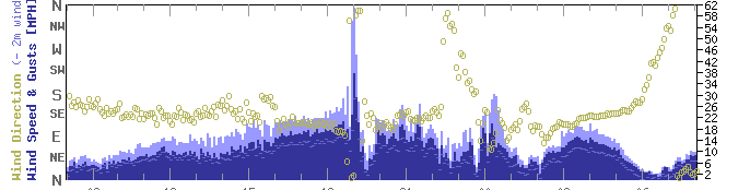
The storms moved southeast with large hail becoming primary threat as they moved over Clinton, OK. Other thunderstorms developed over the Texas panhandle and moved into far southwest Oklahoma and adjacent portions of western north Texas. These storms moved over mainly rural areas of Hardeman Foard counties, with large hail likely occurring and wind gusts over 60 mph (See Goodlett Meteogram image below).
PRELIMINARY LOCAL STORM REPORT...SUMMARY
NATIONAL WEATHER SERVICE NORMAN OK
1041 AM CDT TUE APR 10 2012

  ..TIME...   ...EVENT...      ...CITY LOCATION...     ...LAT.LON...
  ..DATE...   ....MAG....      ..COUNTY LOCATION..ST.. ...SOURCE....
              ..REMARKS..

  0337 PM     HAIL             4 NNW SELMAN            36.86N 99.52W
  04/09/2012  E0.88 INCH       HARPER             OK   TRAINED SPOTTER

  0416 PM     HAIL             7 SE SELMAN             36.73N 99.40W
  04/09/2012  E1.75 INCH       HARPER             OK   TRAINED SPOTTER

  0426 PM     HAIL             1 S FORT SUPPLY         36.56N 99.57W
  04/09/2012  E0.88 INCH       WOODWARD           OK   TRAINED SPOTTER

  0441 PM     HAIL             10 SE SELMAN            36.70N 99.36W
  04/09/2012  E2.75 INCH       HARPER             OK   TRAINED SPOTTER

  0450 PM     HAIL             6 NW WOODWARD           36.50N 99.47W
  04/09/2012  E2.25 INCH       WOODWARD           OK   PUBLIC

  0452 PM     HAIL             5 N WOODWARD            36.51N 99.39W
  04/09/2012  E2.50 INCH       WOODWARD           OK   TRAINED SPOTTER

  0454 PM     HAIL             2 N WOODWARD            36.46N 99.39W
  04/09/2012  E2.50 INCH       WOODWARD           OK   TRAINED SPOTTER

  0456 PM     HAIL             1 N WOODWARD            36.45N 99.39W
  04/09/2012  E2.75 INCH       WOODWARD           OK   TRAINED SPOTTER

  0500 PM     HAIL             2 N WOODWARD            36.46N 99.39W
  04/09/2012  E4.25 INCH       WOODWARD           OK   TRAINED SPOTTER

  0502 PM     HAIL             1 N WOODWARD            36.45N 99.39W
  04/09/2012  E2.50 INCH       WOODWARD           OK   EMERGENCY MNGR

  0505 PM     HAIL             1 NE WOODWARD           36.44N 99.38W
  04/09/2012  E2.50 INCH       WOODWARD           OK   CO-OP OBSERVER

  0521 PM     HAIL             WOODWARD                36.43N 99.39W
  04/09/2012  E4.25 INCH       WOODWARD           OK   EMERGENCY MNGR

              *** 3 INJ *** THE HAIL BROKE MULTIPLE WINDOWS AND DENTED
              SEVERAL CARS.

  0524 PM     TORNADO          3 SSW WOODWARD          36.39N 99.41W
  04/09/2012                   WOODWARD           OK   STORM CHASER

              THE TORNADO LASTED FOR LESS THAN A MINUTE.

  0549 PM     TORNADO          3 N SHARON            36.32N 99.34W
  04/09/2012                   WOODWARD           OK   STORM CHASER

              A BRIEF TORNADO OCCURRED NORTH OF SHARON AND MOVED
              SOUTHEAST. NO DAMAGE OCCURRED WITH THE TORNADO.

  0552 PM     TORNADO          3 E SHARON              36.28N 99.28W
  04/09/2012                   WOODWARD           OK   EMERGENCY MNGR

              MULTIPLE STORM CHASERS, LOCAL BROADCAST MEDIA, AND THE
              WOODWARD COUNTY EMERGENCY MANAGEMENT REPORTED A TORNADO
              EAST OF SHARON. THE TORNADO DEVELOPED TO THE
              EAST-NORTHEAST OF SHARON AND MOVED SOUTHEAST, DESTROYING
              A 20 BY 40 FOOT METAL SHED AND DETACHING A ROOF FROM A
              HOME. THE TORNADO LASTED FOR 3 TO 4 MINUTES. THE TIME AND
              LOCATION ARE APPROXIMATE BASED ON RADAR.

  0622 PM     HAIL             2 W WOODWARD            36.43N 99.43W
  04/09/2012  E4.00 INCH       WOODWARD           OK   TRAINED SPOTTER

  0638 PM     HAIL             5 W SHARON              36.28N 99.43W
  04/09/2012  E3.50 INCH       WOODWARD           OK   TRAINED SPOTTER

  0701 PM     HAIL             1 W VICI                36.15N 99.32W
  04/09/2012  E2.50 INCH       DEWEY              OK   STORM CHASER

              THE BACK WINDSHIELD OF A CAR WAS SHATTERED.

  0705 PM     HAIL             VICI                    36.15N 99.30W
  04/09/2012  E1.50 INCH       DEWEY              OK   STORM CHASER

  0800 PM     TSTM WND GST     3 W GOODLETT            34.33N 99.93W
  04/09/2012  M62.00 MPH       HARDEMAN           TX   MESONET

  0900 PM     HAIL             2 E CLINTON             35.51N 98.94W
  04/09/2012  E1.00 INCH       CUSTER             OK   TRAINED SPOTTER

              REPORTED AT THE LUCKY STAR CASINO.

&&

$$
|
 Photo Courtesy of Kim Garcia |
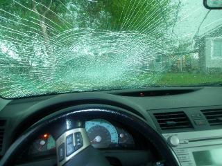 Photo Courtesy of Alecia Merriott |
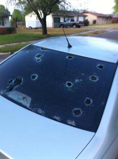 Photo Courtesy of Maria Everett |
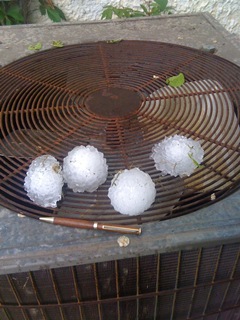 Photo Courtesy of Bill Wyatt |
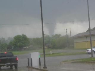 Photo Courtesy of Edwina Zumwalt |
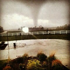 Photo Courtesy of Shannon Wickware |
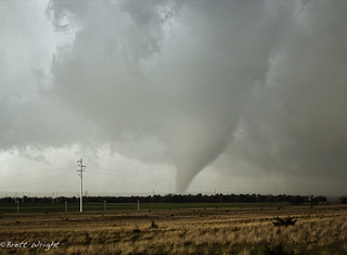 Photo Courtesy of Brett Wright |


