
A heat wave over the Southwest will intensify this week, peaking and expanding into the Intermountain West and northern High Plains this weekend. Critical to extremely critical fire weather conditions are forecast from the Northwest and the northern Great Basin this weekend. Particularly Dangerous Situation Red Flag Warnings have been issued. Read More >

| Caddo County, OK Tornadoes Prior to 1950 | |||||||||
| # | Date | Time (CST) |
Path Length (miles) |
Path Width (yards) |
F-Scale | Killed | Injured | County | Path |
|---|---|---|---|---|---|---|---|---|---|
| 10/30/1903 | 2100 | 4 | 880 | 2 | 4 | Caddo | Near Hydro | ||
| 04/27/1912 | 1230 | 85 | 880 | 15 | 39 | Kiowa/ Washita/ Caddo/ Canadian | Lugert - near Hobart - Colony - near Hinton - near Calumet | ||
| 03/15/1919 | 1730 | 1 | 3 | Custer/ Caddo | 4 SE Weatherford | ||||
| 03/15/1919 | 1830 | *18 | Caddo | Near Hinton | |||||
| 04/14/1921 | 2200 | 0 | 0 | Caddo | 9 NW Carnegie | ||||
| 04/11/1927 | 1800 | 52 | 500 | 1 | 7 | Caddo/ Grady/ Canadian | Near Alfalfa - near Mustang | ||
| 04/19/1929 | 1900 | 15 | 1320 | 3 | 35 | Kiowa/ Caddo | 10 SW Mountain View - ? | ||
| 03/30/1933 | 1500 | 0 | 0 | Caddo | NW of Apache | ||||
| 05/01/1936 | 1845 | 2 | 440 | 3 | 11 | Caddo | Albert | ||
| 05/16/1946 | 2000 | 850 | 0 | 0 | Caddo | Near Carnegie | |||
| 04/04/1947 | 1730 | n | 0 | 0 | Caddo | "Pleasant View" (6 NNE Carnegie) | |||
| 04/04/1947 | 1730 | 15 | n | 0 | 0 | Caddo | 2 S Carnegie - 4 N Fort Cobb | ||
| 05/17/1949 | 1820 | 7 | 300 | 0 | 0 | Caddo | Near Binger | ||
| 06/02/1949 | 1900 | 67 | 0 | 0 | Caddo | 3 NE Alfalfa | |||
| Caddo County, OK Tornadoes (1950-Present*) | |||||||||
| # | Date | Time (CST) |
Path Length (miles) |
Path Width (yards) |
F-Scale | Killed | Injured | County | Path |
| 1 | 02/19/1951 | 1830 | 44 | 20 | F2 | 0 | 5 | Caddo/ Canadian/ Kingfisher | Spring Creek community (8 NE Gracemont) - Ft. Reno - 6 E Okarche (southern Kingfisher County) |
| 2 | 03/24/1954 | 1530 | 4 | 77 | F2 | 0 | 0 | Caddo | 4 ESE- ENE of Alfalfa |
| 3 | 04/26/1954 | 1800 | 1 | 50 | F0 | 0 | 0 | Caddo | Near Carnegie |
| 4 | 05/01/1954 | 1650 | 12 | 300 | F2 | 0 | 0 | Caddo | Near Broxton - Near Washita |
| 5 | 04/26/1955 | 1815 | 0.1 | 10 | F2 | 0 | 0 | Caddo | 1 N Carnegie |
| 6 | 04/26/1955 | 1815 | 0.1 | 10 | F0 | 0 | 0 | Caddo | S of Carnegie |
| 7 | 04/26/1955 | 1830 | 2 | 10 | F2 | 0 | 0 | Caddo | near Gracemont |
| 8 | 06/04/1955 | 1900 | 0.1 | 300 | F2 | 0 | 0 | Caddo | near Hydro |
| 9 | 04/22/1957 | 2000 | 1 | 200 | F3 | 0 | 1 | Caddo | Carnegie |
| 10 | 04/22/1957 | 2015 | 31 | 10 | F2 | 0 | 0 | Caddo/ Canadian | between Binger and Eakly - N of Calumet |
| 11 | 05/12/1957 | 2200 | 0.1 | 10 | F0 | 0 | 0 | Caddo | 12 S Carnegie |
| 12 | 05/22/1957 | 0615 | 15 | 10 | F2 | 0 | 0 | Kiowa/ Washita/ Caddo | 5 SW Mountain View - near Eakly |
| 13 | 04/02/1958 | 1755 | 15 | 880 | F1 | 0 | 1 | Comanche/ Caddo | Near Elgin - E of Cement |
| 14 | 05/16/1958 | 1048 | 0.1 | 10 | F0 | 0 | 0 | Caddo | near Carnegie |
| 15 | 06/06/1958 | 1855 | 0.5 | 33 | F1 | 0 | 0 | Caddo | near Eakly |
| 16 | 11/17/1958 | 0700 | 5 | 10 | F2 | 0 | 0 | Caddo | 5 SW- just NW of Apache |
| 17 | 03/25/1959 | 1448 | 6 | 40 | F0 | 0 | 0 | Caddo | Near Anadarko |
| 18 | 07/22/1959 | 1900 | 0.5 | 440 | F1 | 0 | 0 | Caddo | 1 W Albert |
| 19 | 04/28/1960 | 1900 | 3 | 100 | F3 | 0 | 0 | Caddo | 1.5 SW of Oney (which is now Albert) |
| 20 | 05/19/1960 | 1600 | 0.1 | 10 | F0 | 0 | 0 | Caddo | SE of Anadarko |
| 21 | 05/19/1960 | 1600 | 0.1 | 10 | F1 | 0 | 0 | Caddo/ Grady | N of Verden - near Dutton |
| 22 | 05/23/1960 | 1830 | 0.1 | 10 | F2 | 0 | 1 | Caddo | Carnegie |
| 23 | 05/23/1960 | 1830 | 0.1 | 10 | F2 | 0 | 0 | Caddo | Near Carnegie |
| 24 | 05/23/1960 | 1830 | 0.1 | 10 | F2 | 0 | 0 | Caddo | Near Carnegie |
| 25 | 05/21/1961 | 1733 | 0.1 | 10 | F? | 0 | 0 | Caddo | 3 NW Anadarko |
| 26 | 06/16/1963 | 0430 | 0.1 | 10 | F1 | 0 | 0 | Caddo | 3 WSW Anadarko |
| 27 | 05/06/1964 | 0100 | 8 | 300 | F0 | 0 | 0 | Caddo | 5 NE Fort Cobb |
| 28 | 05/10/1964 | 1745 | 12 | 10 | F2 | 0 | 1 | Caddo | Near Alfalfa - Fort Cobb Lake - 9 ENE Fort Cobb Lake |
| 29 | 04/05/1965 | 1000 | 0.1 | 10 | F1 | 0 | 0 | Caddo | 5 WNW Anadarko |
| 30 | 04/07/1965 | 2350 | 22 | 440 | F2 | 0 | 2 | Caddo/ Grady | Anadarko - 3 W Amber |
| 31 | 06/01/1965 | 2209 | 0.1 | 10 | F0 | 0 | 0 | Caddo | Fort Cobb Lake |
| 32 | 06/08/1966 | 1730 | 0.5 | 10 | F1 | 0 | 0 | Caddo | W part of Hinton |
| 33 | 06/08/1966 | 1920 | 0.1 | 10 | F0 | 0 | 0 | Caddo | 4 SE Gracemont |
| 34 | 04/20/1967 | 1340 | 1 | 200 | F3 | 0 | 0 | Caddo | 5 N Cyril |
| 35 | 12/18/1968 | 0830 | 1.8 | 300 | F2 | 0 | 0 | Caddo | 2 NNE Apache |
| 36 | 04/29/1970 | 2355 | 12 | 200 | F1 | 0 | 0 | Caddo | 1 S Carnegie - Fort Cobb Lake |
| 37 | 06/18/1973 | 1645 | 17 | 133 | F3 | 0 | 0 | Caddo | 5 W Binger - 4 E Carnegie |
| 38 | 06/18/1973 | 1800 | 0.5 | 67 | F2 | 0 | 0 | Caddo | 8 WSW Anadarko |
| 39 | 04/17/1976 | 0412 | 33 | 440 | F4 | 0 | 6 | Caddo | 8 W Apache- near Broxton- Washita |
| 40 | 05/20/1977 | 1647 | 13 | 1100 | F2 | 0 | 0 | Caddo | ~5 W Fort Cobb - Albert |
| 41 | 05/20/1977 | 1710 | 8 | 1760 | F2 | 0 | 0 | Caddo | Binger - ~3 E Lookeba |
| 42 | 06/06/1979 | 1700 | 0.3 | 17 | F1 | 0 | 0 | Caddo | E of Anadarko |
| 43 | 04/30/1981 | 2000 | 32 | 10 | F1 | 0 | 0 | Caddo/ Grady | near Gracemont - Anadarko - near Rush Springs |
| 44 | 05/22/1981 | 1807 | 5 | 300 | F2 | 0 | 0 | Washita/ Caddo | 3 ESE- ~6 ENE Cowden |
| 45 | 05/22/1981 | 1829 | 0.3 | 10 | F0 | 0 | 0 | Caddo | Swan Lake (NE shore of Ft. Cobb Lake) |
| 46 | 05/22/1981 | 1830 | 15 | 100 | F2 | 0 | 0 | Kiowa/ Washita/ Caddo | N of Mountain View - 6 N Alfalfa |
| 47 | 05/22/1981 | 1849 | 17 | 1333 | F4 | 0 | 0 | Caddo/ Canadian | 1 W Binger- 11 WNW Union City |
| 48 | 06/01/1981 | 1900 | 0.1 | 10 | F0 | 0 | 0 | Caddo | Near Binger |
| 49 | 05/20/1982 | 1904 | 0.5 | 50 | F1 | 0 | 0 | Caddo | Apache |
| 50 | 05/27/1982 | 1920 | 0.5 | 50 | F1 | 0 | 0 | Caddo | Carnegie |
| 51 | 05/27/1982 | 1925 | 0.5 | 50 | F2 | 0 | 13 | Caddo | Fort Cobb Lake |
| 52 | 05/30/1982 | 1825 | 0.1 | 10 | F0 | 0 | 0 | Caddo | N of Carnegie |
| 53 | 05/30/1982 | 1830 | 1.5 | 50 | F1 | 0 | 0 | Caddo | W of Eakly |
| 54 | 05/30/1982 | 1930 | 0.1 | 10 | F0 | 0 | 0 | Caddo | NE of Fort Cobb Lake |
| 55 | 05/13/1983 | 2145 | 2 | 50 | F2 | 0 | 0 | Caddo | 5 W- 4 WSW Anadarko |
| 56 | 05/13/1983 | 2150 | 0.1 | 50 | F0 | 0 | 0 | Caddo | 10 W Apache |
| 57 | 05/13/1983 | 2210 | 0.1 | 50 | F2 | 0 | 0 | Caddo | 4 E Anadarko |
| 58 | 06/10/1983 | 1939 | 0.1 | 10 | F0 | 0 | 0 | Caddo | 3 SW Hinton |
| 59 | 06/10/1983 | 2100 | 0.1 | 10 | F0 | 0 | 0 | Caddo | Near Hinton |
| 60 | 06/13/1983 | 1830 | 0.1 | 10 | F0 | 0 | 0 | Caddo | 2 SE Binger |
| 61 | 06/13/1983 | 1845 | 0.1 | 10 | F0 | 0 | 0 | Caddo | 2 S Hydro |
| 62 | 05/16/1986 | 2035 | 0.2 | 50 | F1 | 0 | 0 | Caddo | 6 E Hydro |
| 63 | 05/16/1986 | 2130 | 0.2 | 50 | F0 | 0 | 0 | Caddo | 1 W Anadarko |
| 64 | 02/14/1987 | 1805 | 4 | 100 | F1 | 0 | 0 | Caddo | 3 SW- 2 NW Apache |
| 65 | 05/26/1990 | 1900 | 3 | 200 | F3 | 0 | 0 | Caddo | 2 E- 4 SE Hinton |
| 66 | 05/26/1990 | 1955 | 2 | 200 | F2 | 0 | 0 | Caddo | 2 E- 4 ESE Binger |
| 67 | 08/21/1996 | 1535 | 0.1 | 25 | F0 | 0 | 0 | Caddo | 7 NW Cyril |
| 68 | 11/16/1996 | 1600 | 1 | 30 | F0 | 0 | 0 | Caddo | 3 NE Apache |
| 69 | 05/25/1997 | 1627 | 0.2 | 23 | F0 | 0 | 0 | Caddo/ Comanche | 4 SW Cyril/1 N Fletcher |
| 70 | 10/04/1998 | 1745 | 0.5 | 30 | F0 | 0 | 0 | Caddo | 1 NE Cyril |
| 71 | 05/03/1999 | 1620-1635 | 6 | 100 | F3 | 0 | 3 | Caddo | 3 E Apache - 2 NE Stecker |
| 72 | 05/03/1999 | 1626 | 0.1 | n/a | F0 | 0 | 0 | Caddo | 3 NW Cyril |
| 73 | 05/03/1999 | 1638 | 0.1 | n/a | F0 | 0 | 0 | Caddo | 2 S Anadarko |
| 74 | 05/03/1999 | 1646-1710 | 9 | 880 | F3 | 0 | 4 | Caddo/ Grady | 2 WSW Laverty - 4 S Verden - 2.5 WNW Downtown Chickasha |
| 75 | 05/03/1999 | 1720-1724 | 2 | n/a | F0 | 0 | 0 | Caddo | 12 WNW Apache |
| 76 | 05/03/1999 | 1738-1759 | 7 | 150 | F1 | 0 | 0 | Caddo | 8 S Fort Cobb - 1 W Washita |
| 77 | 05/03/1999 | 1756 | 0.1 | n/a | F0 | 0 | 0 | Caddo | 5 W Anadarko |
| 78 | 05/03/1999 | 1812-1813 | 1 | n/a | F0 | 0 | 0 | Caddo | 4 NNW - 5 NNW Anadarko |
| 79 | 05/03/1999 | 1820 | 0.1 | n/a | F0 | 0 | 0 | Caddo | 4 ESE Gracemont |
| 80 | 05/03/1999 | 1834-1835 | 0.5 | n/a | F0 | 0 | 0 | Caddo | 9 E - 10 ENE Gracemont |
| 81 | 05/03/1999 | 1837-1848 | 5 | 50 | F1 | 0 | 0 | Caddo | 5 S - 1 E Cogar |
| 82 | 05/26/2000 | 1812-1828 | 3 | 20 | F0 | 0 | 0 | Washita/ Caddo | 2 SSE - 3 ESE Colony (3 W Eakly) |
| 83 | 05/26/2000 | 1847 | 0.1 | 20 | F0 | 0 | 0 | Caddo | 1.5 ESE Eakley |
| 84 | 05/26/2000 | 1857-1903 | 3 | 100 | F0 | 0 | 0 | Caddo | 6.5 W - 5 WSW Binger |
| 85 | 10/22/2000 | 1514-1526 | 4 | 30 | F0 | 0 | 0 | Caddo | 6 SE - 6 ENE Binger |
| 86 | 10/09/2001 | 1718-1722 | 2 | 300 | F1 | 0 | 0 | Caddo | 1.5 E - 3 ENE Alfalfa |
| 87 | 10/09/2001 | 1728 | 0.4 | 25 | F0 | 0 | 0 | Caddo | 2 NW Carnegie |
| 88 | 10/09/2001 | 1757-1758 | 0.8 | 50 | F1 | 0 | 0 | Caddo | 3 S - 3 SSE Albert |
| 89 | 10/09/2001 | 1805-1810 | 2 | 440 | F1 | 0 | 0 | Caddo | 7 S Binger - 3.5 NW Gracemont |
| 90 | 10/09/2001 | 1815-1819 | 1.5 | 580 | F0 | 0 | 0 | Caddo | 5 N Gracemont - 3.5 WSW Spring Creek |
| 91 | 10/09/2001 | 1820-1824 | 1.5 | 850 | F1 | 0 | 0 | Caddo | 5 W - 4 WNW Spring Creek |
| 92 | 05/09/2003 | 1950 | 0.2 | 25 | F0 | 0 | 0 | Caddo | 2.5 NNE Eakly |
| 93 | 05/09/2003 | 2000-2002 | 1 | 100 | F1 | 0 | 0 | Caddo | 6 E - 7 E Binger |
| 94 | 05/09/2003 | 2017-2020 | 1.2 | 50 | F0 | 0 | 0 | Caddo/ Grady | 1.4 NE - 2.5 ENE Cogar |
| 95 | 05/24/2004 | 1721 | 0.2 | 25 | F1 | 0 | 0 | Caddo | near Alfalfa |
| 96 | 05/24/2004 | 1727 | 0.2 | 30 | F1 | 0 | 0 | Caddo | 2.5 E Eakly |
| 97 | 08/19/2007 | 0100-0106 | 3 | 30 | EF0 | 0 | 0 | Caddo/ Canadian | 1.7 ENE Cogar - 9 W Union City |
| 98 | 03/30/2008 | 2044-2046 | 0.5 | 20 | EF0 | 0 | 0 | Caddo | 1 W Albert |
| 99 | 03/30/2008 | 2122 | 0.1 | 20 | EF0 | 0 | 0 | Caddo | 4 W Cogar |
| 100 | 05/13/2009 | 2026-2040 | 7 | 250 | EF2 | 0 | 0 | Caddo | 2 SSE Gracemont - 2 SE Anadarko |
| 101 | 07/03/2010 | 1645 | 0.1 | 25 | EF0 | 0 | 0 | Caddo | 1.5 WSW Bridgeport |
| 102 | 05/19/2011 | 1709 | 0.2 | 40 | EF0 | 0 | 0 | Caddo | 2 SE Fort Cobb |
| 103 | 05/19/2011 | 1740 | 0.2 | 20 | EF0 | 0 | 0 | Caddo | 3 W Apache |
| 104 | 05/24/2011 | 1431-1446 | 9 | 800 | EF3 | 0 | 0 | Caddo | 4 WSW - 4 NE Lookeba |
| 105 | 11/07/2011 | 1640-1648 | 3 | 150 | EF0 | 0 | 0 | Caddo | 8 SSE - 6 SE Carnegie |
| 106 | 11/07/2011 | 1651-1717 | 13 | 400 | EF1 | 0 | 0 | Caddo | 6 SW Fort Cobb - 2 SW Albert |
| 107 | 04/13/2012 | 1936-1938 | 2 | 50 | EF0 | 0 | 0 | Caddo | 3 S Carnegie |
| 108 | 04/13/2012 | 1942 | 0.3 | 50 | EF0 | 0 | 0 | Caddo | 8 SSE Carnegie |
| 109 | 04/13/2012 | 1950-1955 | 4 | 100 | EF0 | 0 | 0 | Caddo | 6 SSE - 7 SE Carnegie |
| 110 | 05/06/2015 | 1345-1347 | 2 | 50 | EF0 | 0 | 0 | Caddo | 2.5 E - 3 ENE Apache |
| 111 | 05/06/2015 | 1353-1355 | 0.5 | 50 | EF0 | 0 | 0 | Caddo | 4 NW Cyril |
| 112 | 05/06/2015 | 1737-1750 | 5 | 200 | EF0 | 0 | 0 | Caddo | 4 NNW - 6 N Verden |
| 113 | 05/16/2015 | 1855-1858 | 2 | 50 | EF0 | 0 | 0 | Caddo | 4 NW - 5 NNW Cyril |
| 114 | 05/16/2015 | 1901-1905 | 3 | 50 | EF0 | 0 | 0 | Caddo | 5 NNW Cyril - 5 NW Cement |
| 115 | 05/26/2015 | 1732 | 0.2 | 30 | EF0 | 0 | 0 | Custer/ Caddo | 3 WSW Hydro |
| 116 | 04/29/2016 | 1454-1454 | 0.5 | 20 | EF0 | 0 | 0 | Caddo | 4.5 ESE Cyril |
| 117 | 10/21/2017 | 1808-1816 | 5 | 200 | EF1 | 0 | 0 | Caddo | 4 W - 2 N Cyril |
| 118 | 10/21/2017 | 1812-1813 | 0.5 | 50 | EF1 | 0 | 0 | Caddo | 3.5 NW Cyril |
| 119 | 10/21/2017 | 1812-1824 | 6 | 400 | EF1 | 0 | 0 | Caddo | 4 NW Cyril - 4 NNW Cement |
| 120 | 10/21/2017 | 1816-1821 | 3 | 150 | EF1 | 0 | 0 | Caddo | 4 E Stecker - 5 NW Cement |
| 121 | 10/21/2017 | 1823-1828 | 3 | 100 | EF1 | 0 | 0 | Caddo | 2 NNE - 4 NE Cement |
| 122 | 10/10/2021 | 1720-1725 | 4 | 50 | EF1 | 0 | 0 | Caddo | 9 W - 6 WNW Boone |
| 123 | 10/10/2021 | 1745-1759 | 8 | 100 | EF2 | 0 | 0 | Caddo | 4 SW - 5 E Anadarko |
| 124 | 10/10/2021 | 1802-1805 | 1.8 | 50 | EF? | 0 | 0 | Caddo/ Grady | 3 SW - 1 SSE Verden |
| 125 | 10/12/2021 | 2035-2036 | 0.5 | 30 | EF? | 0 | 0 | Caddo | 5 NW Boone |
| 126 | 05/02/2022 | 1536-1538 | 1.6 | 10 | EF0 | 0 | 0 | Caddo | 1.2 SW - 0.7 E Hydro |
| 127 | 05/02/2022 | 1613-1614 | 0.5 | 240 | EF1 | 0 | 0 | Caddo | 1.5 N - 1 NNE Cyril |
| 128 | 02/26/2023 | 2032-2039 | 5 | 75 | EF0 | 0 | 0 | Caddo | 1 NW Gracemont |
| 129 | 04/27/2024 | 1510-1512 | 0.8 | 20 | EF0 | 0 | 0 | Caddo | 3 SW - 2.5 SW Hinton |
| 130 | 05/19/2024 | 1924-1925 | 1 | 40 | EF0 | 0 | 0 | Caddo | Hydro - 1 SSE Hydro |
| 131 | 05/19/2024 | 1937-1939 | 0.6 | 50 | EF1 | 0 | 0 | Blaine/ Caddo | 3 W Bridgeport |
| Date | Time (CST) |
Path Length (miles) |
Path Width (yards) |
F-Scale | Killed | Injured | County | Path | |
|---|---|---|---|---|---|---|---|---|---|
| 02/19/1951 | 1830-2000 | 44 | 20 | F2 | 0 | 5 | Caddo/ Canadian/ Kingfisher | Spring Creek community (8 NE Gracemont) - Ft. Reno - 6 E Okarche (southern Kingfisher County) | |
|
This tornado struck the Spring Creek community in northern Caddo County at 6:30 pm CST, injuring 5 people from one family when a house collapsed in the area. A store and a vacant house were also damaged in the community. The tornado continued northeastward into Canadian County, striking the Fort Reno area at 7:17 pm CST before dissipating 6 miles east of Okarche in southern Kingfisher County at 8:00 pm CST. The hail that accompanied the tornado in Kingfisher County caused $500 in property damage. Estimated damage from this tornado was $32,500. The Fort Reno area incurred about $15,000 in damages and several buildings were demolished including a large barracks and large hay shed while other buildings were damaged including Lucas Hall. The weather equipment at Fort Reno was destroyed with the rain gauge being found several hundred yards from its original location. Several farms in Canadian County were also damaged. |
|||||||||
| 04/22/1957 | 2000 | 1 | 200 | F3 | 0 | 1 | Caddo | Carnegie | |
|
A tornado moved northeastward though the town of Carnegie, unroofed some houses, and ripped away the porches on some homes. A person was injured when their car was blown off of a local road within the town. |
|||||||||
| 04/02/1958 | 1755 | 15 | 880 | F1 | 0 | 1 | Comanche/ Caddo | Near Elgin - E of Cement | |
|
Extensive damage resulted from a tornado which hit in the Elgin area in Comanche County at about 6:00 pm CST. Roofs and porches on some houses as well as a church, the high school gymnasium, and utility poles received damage from the storm. One injury was reported. The tornado moved northeastward and crosses into Caddo County where it hit a pear orchard and farm just east of Cement. Many trees were uprooted in the orchard. |
|||||||||
| 05/23/1960 | 1830 | 0.1 | 10 | F2 | 0 | 1 | Caddo | Carnegie | |
|
This tornado was one of three tornadoes that were observed in the Carnegie-Fort Cobb area, and the 3 tornadoes were spaced about one mile apart from each other. This tornado destroyed a peanut warehouse and damaged 3 homes at the southwestern edge of Carnegie. Flying timbers from the warehouse struck one of the homes and injured a woman. |
|||||||||
| 05/10/1964 | 1745 | 12 | 10 | F2 | 0 | 1 | Caddo | Near Alfalfa - Fort Cobb Lake - 9 ENE Fort Cobb Lake | |
|
This tornado caused extensive damage in the Willow Creek area near Alfalfa before moving to the northeast over Fort Cobb Lake between 5:45 pm and 6:00 pm CST. Extensive damage occurred on the west side of the reservoir, particularly in the Swan Lake and Long's Cabin site areas. One girl was injured when an entire roof blew off of a cabin. Another cabin, which was under construction, was twisted 10 feet off of its foundation, and two other cabins were destroyed. Three mobile homes were destroyed, and one, a 60-foot mobile home, was ripped from its frame and tossed 100 feet into a pasture. More damage occurred 9 miles east-northeast of Fort Cobb Lake where the roof of a home was damaged, trees were uprooted, and a barn was destroyed. The entire roof of a nearby Binger peanut plant was also torn away. |
|||||||||
| 04/07/1965 | 2350 | 22 | 440 | F2 | 0 | 2 | Caddo/ Grady | Anadarko - 3 W Amber | |
|
A tornado touched in Caddo County in the northwest section of Anadarko and moved east-northeast across the northern part of the city, destroying a large freight dock. A bus barn and 7 buses within were damaged. A 120-patient rest home was damaged while several homes in the northern part of Anadarko were destroyed. In addition, several cars were overturned, trees were ripped from the ground, a police communications tower was toppled, and telephone services were knocked out. Two people were injured as the tornado moved east-northeastward past Verden and destroyed 4 homes and 4 barns. One man was injured near Anadarko, and one woman was injured when the wall of a storm cellar caved in and trapped one of her legs near Verden. The tornado also produced damage at Lake Chickasha, destroying 3 mobile homes and heavily damaging 2 other mobile homes. A farmer observed the tornado as it lifted 4.5 north-northeast of Verden. Either the same tornado or a new tornado produced damage 3 miles west of Amber where a large chicken house was demolished and the south side of a barn was torn away. |
|||||||||
| 04/17/1976 | 0412 | 33 | 440 | F4 | 0 | 6 | Caddo | 8 W Apache- near Broxton- Washita | |
|
This violent tornado touched down 8 miles west of Apache on OK State Highway 19 in southwestern Caddo County. It moved northeastward at 35 mph along a 33-mile path to north of Broxton, and then through the west edge of the town of Washita, before dissipating in northeastern Caddo County. The tornado was estimated to be on the ground for 32 minutes. Six people were injured, 3 of which were admitted to a hospital. Fortunately, there were no serious injuries. The F4 damage occurred to the north of Broxton and the tornado caused extensive damage to 6 cooling towers at a power plant in Washita. |
|||||||||
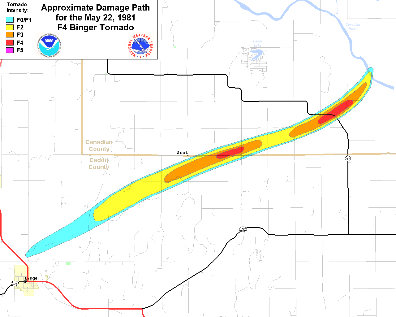
| 05/22/1981 | 1849 | 17 | 1333 | F4 | 0 | 0 | Caddo/ Canadian | 1 W Binger- 11 WNW Union City | |
|
This large tornado formed a mile west of Binger, OK and moved northeast through northeastern Caddo County and southwestern Canadian County before dissipating at the Canadian River 11 miles west and 3 miles north of Union City. This large, intense tornado created projectiles from refrigerators automobiles, trucks, combines, and utility poles. Dead cattle were founded hanging from denuded trees. Large oil storage tanks, butane tanks, and motor vehicles were moved to distances up to a half mile by the tornadic winds. Fortunately, all farmsteads in the path of the tornado had underground shelters, and the occupants were able to take shelter during the storm. The tornado was rated F4, and a Fujita Scale damage path map shows the tornado path length, width and approximate damage intensity. |
|||||||||
| 05/27/1982 | 1925 | 0.5 | 50 | F2 | 0 | 13 | Caddo | Fort Cobb Lake | |
|
A tornado touched down and destroyed the Forb Cobb Lake marina, and damaged or destroyed 25 to 30 boats. Thirteen people received minor injuries. |
|||||||||
| 05/03/1999 | 1620-1635 | 6 | 100 | F3 | 0 | 3 | Caddo | 3 E Apache - 2 NE Stecker | |
|
A record outbreak of tornadoes struck Oklahoma from late afternoon of May 3, 1999, through early morning of May 4, 1999. A total of 57 tornadoes have been recorded across portions of western and central Oklahoma. This tornado touched down in a rural area 3 miles east of Apache in Caddo County. As the tornado moved northward to near Anadarko, one house was destroyed near the town of Stecker, with its roof ripped off and several walls knocked down indicating F3 damage. Three people inside the house were injured. |
|||||||||
| 05/03/1999 | 1646-1710 | 9 | 880 | F3 | 0 | 4 | Caddo/ Grady | 2 WSW Laverty - 4 S Verden - 2.5 WNW Downtown Chickasha | |
|
This tornado developed about 3 miles north-northeast of Cement (or 2 miles west-southwest of Laverty) near the Caddo/Grady County border, and quickly intensified to a strong tornado with associated damage rated at the high end of the F3 scale. The tornado tracked northeast for 9 miles before dissipating 2.5 miles west-northwest of downtown Chickasha. Two homes had just a few interior walls standing (F3), one located near U.S. Highway 62 on the northwest side of Chickasha, and several wooden high tension power lines were downed. Several persons were injured south of Verden near the Caddo/Grady County border. |
|||||||||
Records taken from the Storm Prediction Center archive data, "Storm Data", and data from the National Weather Service office in Norman. Data modified as described in NOAA Tech Memo NWS SR-209 (Speheger, D., 2001: "Corrections to the Historic Tornado Database").
Historic data, especially before 1950, are likely incomplete.

