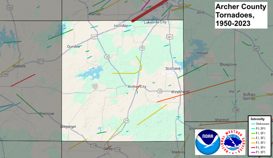
| Archer County, TX Tornadoes Prior to 1950 | |||||||||
| # | Date | Time (CST) |
Path Length (miles) |
Path Width (yards) |
F-Scale | Killed | Injured | County | Path |
|---|---|---|---|---|---|---|---|---|---|
| 05/17/1929 | 1430 | 440 | 3 | Archer | Near Dundee | ||||
| 05/15/1930 | 1730 | 440 | 6 | Archer | Near Dundee - near Mankins | ||||
| 03/26/1938 | 250 | Archer | Near Mankins | ||||||
| Archer County, TX Tornadoes (1950-Present*) | |||||||||
| # | Date | Time (CST) |
Path Length (miles) |
Path Width (yards) |
F-Scale | Killed | Injured | County | Path |
| 1 | 06/08/1955 | 1500 | 0.1 | 10 | F1 | 0 | 0 | Archer/ Baylor | Lake Diversion |
| 2 | 04/25/1957 | 1605 | 0.1 | 10 | F0 | 0 | 0 | Archer | 10 S Wichita Falls |
| 3 | 05/08/1959 | 2210 | 0.1 | 10 | F0 | 0 | 0 | Archer | Near Holliday |
| 4 | 04/08/1961 | 1500 | 1 | 33 | F3 | 0 | 1 | Archer | Archer City |
| 5 | 04/10/1966 | 1700 | 2 | 27 | F1 | 0 | 0 | Archer | near Lake Olney |
| 6 | 04/10/1979 | 1750 | 47 | 1320 | F4 | 42 | 1740 | Archer TX/ Wichita TX/ Clay TX/ Jefferson OK | 3 ENE Holliday TX- Wichita Falls TX- 4 E Byers TX- NNE of Waurika OK [All fatalities and injuries were in Texas] |
| 7 | 04/02/1980 | 1245 | 0.1 | 10 | F0 | 0 | 0 | Archer | 3 N Lake Kickapoo |
| 8 | 04/02/1980 | 1315 | 0.1 | 10 | F0 | 0 | 0 | Archer | 5 W Holliday |
| 9 | 04/02/1980 | 1316 | 0.1 | 10 | F0 | 0 | 0 | Archer | 1 E Holliday |
| 10 | 05/12/1982 | 1930 | 0.1 | 10 | F1 | 0 | 0 | Archer | N of Lake Kickapoo |
| 11 | 04/21/1985 | 1830 | 5 | 300 | F2 | 0 | 2 | Young/ Archer | 10 W Olney- ~6 WNW Olney |
| 12 | 05/14/1986 | 1830 | 20 | 250 | F3 | 0 | 4 | Archer/ Clay | 5 SE Archer City- Windthorst- 15 S Henrietta |
| 13 | 09/02/1986 | 1130 | 0.2 | 10 | F0 | 0 | 0 | Archer | near Lake Arrowhead (2 N Scotland) |
| 14 | 03/28/1989 | 2114 | 0.2 | 10 | F0 | 0 | 0 | Archer | Lake Diversion |
| 15 | 03/08/1992 | 1759 | 0.2 | 10 | F0 | 0 | 0 | Archer | 1 E Dundee |
| 16 | 05/08/1993 | 1742-1806 | 8 | 90 | F1 | 0 | 0 | Archer/ Clay | 2 ESE Scotland- 5 W Bluegrove |
| 17 | 04/26/1994 | 1150 | 0.1 | 20 | F0 | 0 | 0 | Archer | 3 S Anarene |
| 18 | 04/26/1994 | 1205-1227 | 10 | 150 | F2 | 0 | 0 | Archer | 3 SE Anarene - 4.5 SW Windthorst |
| 19 | 05/29/1994 | 1630 | 0.1 | 30 | F0 | 0 | 0 | Archer | 5 SW Scotland |
| 20 | 05/07/1995 | 1205 | 0.1 | 23 | F0 | 0 | 0 | Archer | 8 E Archer City |
| 21 | 08/17/1997 | 1845-1848 | 0.5 | 73 | F0 | 0 | 0 | Archer | 7 S Windthorst |
| 22 | 08/17/1997 | 1915 | 0.1 | 23 | F0 | 0 | 0 | Archer | 11 S Windthorst |
| 23 | 05/27/2000 | 1224 | 0.2 | 20 | F0 | 0 | 0 | Archer | 3 SW Archer City |
| 24 | 05/27/2000 | 1228-1231 | 1 | 20 | F0 | 0 | 0 | Archer | 1 S - 2 S Archer City |
| 25 | 06/04/2005 | 1838-1839 | 0.2 | 30 | F0 | 0 | 0 | Archer | 7 SE Dundee |
| 26 | 05/06/2015 | 1949-2012 | 12 | 400 | EF2 | 0 | 0 | Archer | 7 WNW - 4 N Archer City |
| 27 | 05/16/2015 | 1822 | 0.2 | 30 | EF0 | 0 | 0 | Archer | Lake Diversion |
| 28 | 05/19/2015 | 1655 | 0.2 | 30 | EF0 | 0 | 0 | Archer | 11 S Windthorst |
| 29 | 05/19/2017 | 1700-1702 | 0.5 | 50 | EF? | 0 | 0 | Archer | 2.5 SW Windthorst |
| 30 | 05/25/2024 | 1616-1624 | 3.4 | 200 | EF1 | 0 | 0 | Archer/ Clay | Windthorst (east portion) - 3 NE Windthorst |
| 31 | 06/03/2025 | 1710-1710 | 0.1 | 50 | EF? | 0 | 0 | Archer | 5 NW Archer City |
Records taken from the Storm Prediction Center archive data, "Storm Data", and data from the National Weather Service office in Norman. Data modified as described in NOAA Tech Memo NWS SR-209 (Speheger, D., 2001: "Corrections to the Historic Tornado Database").
Historic data, especially before 1950, are likely incomplete.