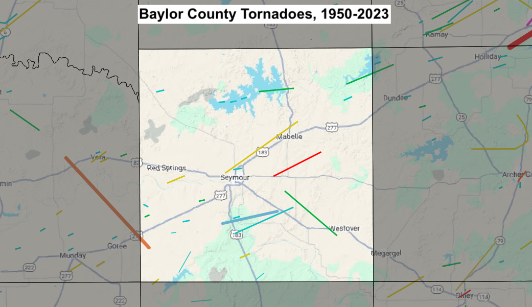
| # | Date | Time (CST) |
Path Length (miles) |
Path Width (yards) |
F-Scale | Killed | Injured | County | Path |
|---|---|---|---|---|---|---|---|---|---|
| Baylor County, TX Tornadoes (1950-Present*) | |||||||||
| 1 | 06/08/1955 | 1500 | 0.1 | 10 | F1 | 0 | 0 | Archer/ Baylor | Lake Diversion |
| 2 | 05/24/1957 | 2030 | 0.1 | 10 | F? | 0 | 0 | Baylor | 10 SW Seymour |
| 3 | 08/12/1957 | 1550 | 0.4 | 100 | F2 | 0 | 0 | Baylor/ Throckmorton | 15 SW Seymour |
| 4 | 10/07/1957 | 1915 | 2 | 10 | F2 | 0 | 0 | Baylor | W of Seymour |
| 5 | 03/08/1958 | 0010 | 1.3 | 33 | F1 | 0 | 0 | Baylor | Seymour and Bomarton areas |
| 6 | 05/15/1959 | 1940 | 0.7 | 100 | F0 | 0 | 0 | Baylor | 35 SW Electra |
| 7 | 05/07/1961 | 2300 | 0.8 | 17 | F0 | 0 | 0 | Baylor | 5 S Seymour |
| 8 | 04/23/1964 | 1630 | 1 | 37 | F1 | 0 | 0 | Baylor | 6 W Dundee |
| 9 | 04/15/1976 | 1838 | 0.1 | 10 | F2 | 0 | 0 | Baylor | 10 S Seymour |
| 10 | 04/10/1979 | 1649 | 10 | 300 | F2 | 0 | 0 | Baylor | NW side of Seymour - 2 NNE Mabelle |
| 11 | 05/20/1979 | 2022 | 0.1 | 10 | F1 | 0 | 0 | Baylor | 10 NE Munday |
| 12 | 04/02/1980 | 1210 | 8 | 250 | F4 | 0 | 0 | Baylor | 5 E- ~11 ENE Seymour |
| 13 | 03/07/1981 | 1600 | 4 | 100 | F1 | 0 | 0 | Baylor | E side of Lake Kemp - 4 E Lake Kemp |
| 14 | 05/24/1981 | 1800 | 0.1 | 10 | F0 | 0 | 0 | Baylor | Lake Kemp |
| 15 | 05/24/1981 | 1805 | 0.1 | 10 | F0 | 0 | 0 | Baylor | Lake Kemp |
| 16 | 05/24/1981 | 1810 | 0.1 | 10 | F0 | 0 | 0 | Baylor | Lake Kemp |
| 17 | 05/14/1986 | 1630 | 1 | 10 | F0 | 0 | 0 | Baylor | 8 SW Seymour |
| 18 | 03/08/1992 | 1705 | 0.2 | 10 | F0 | 0 | 0 | Baylor | 1 N Seymour |
| 19 | 05/08/1993 | 1357-1411 | 8 | 80 | F0 | 0 | 0 | Baylor | 7 S Seymour - 9 S Mabelle |
| 20 | 10/12/1993 | 1712-1732 | 7 | 40 | F1 | 0 | 0 | Baylor | 7 ESE Seymour - 2 WSW Westover |
| 21 | 05/13/2005 | 1809-1850 | 16 | 1000 | F3 | 0 | 0 | Knox/ Baylor | 4 W Vera - 3.3 SW Bomarton |
| 22 | 05/13/2005 | 1851 | 0.2 | 50 | F0 | 0 | 0 | Baylor | 3 NW Bomarton |
| 23 | 04/13/2007 | 1338-1348 | 6 | 880 | EF0 | 0 | 0 | Baylor | 6 SSW Seymour |
| 24 | 03/28/2017 | 1813-1818 | 3 | 50 | EF? | 0 | 0 | Baylor | 7 SSE - 5 SE Bomarton (2 SSW - 1 NNE Millers Creek Reservoir) |
| 25 | 05/01/2019 | 1301-1324 | 1.3 | 200 | EF? | 0 | 0 | Baylor | 13 S Seymour |
| 26 | 04/27/2024 | 1508-1540 | 13 | 300 | EF0 | 0 | 0 | Baylor | 2 E Red Springs - Lake Kemp |
| 27 | 04/27/2024 | 1515-1516 | 0.6 | 30 | EF? | 0 | 0 | Baylor | 8 NW Seymour |
| 28 | 04/29/2025 | 1722-1747 | 12 | 1000 | EF2 | 0 | 0 | Knox/ Baylor | 0.5 SSW Vera - 7 WNW Seymour |
| 29 | 04/29/2025 | 1758-1804 | 4 | 650 | EF3 | 0 | 0 | Baylor | 5.5 NNW - 4 N Seymour |
Records taken from the Storm Prediction Center archive data, "Storm Data", and data from the National Weather Service office in Norman. Data modified as described in NOAA Tech Memo NWS SR-209 (Speheger, D., 2001: "Corrections to the Historic Tornado Database").
Historic data, especially before 1950, are likely incomplete.