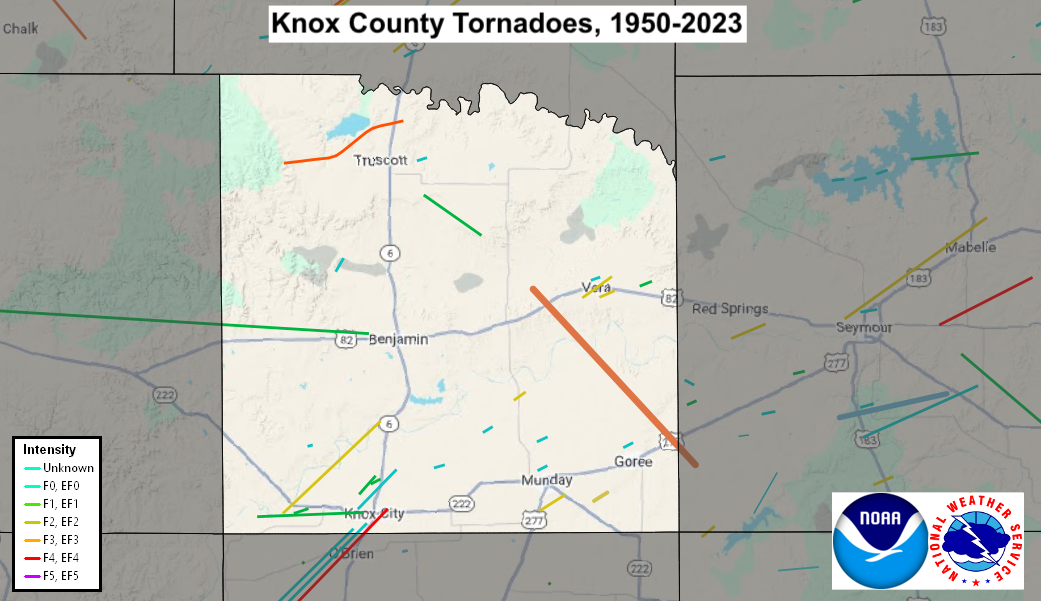
| Knox County, TX Tornadoes Prior to 1950 | |||||||||
| # | Date | Time (CST) |
Path Length (miles) |
Path Width (yards) |
F-Scale | Killed | Injured | County | Path |
|---|---|---|---|---|---|---|---|---|---|
| 05/20/1944 | 2015 | 880 | 0 | Knox | Near Knox City | ||||
| 03/25/1949 | 0710 | 0 | Knox | Benjamin | |||||
| Knox County, TX Tornadoes (1950-Present*) | |||||||||
| # | Date | Time (CST) |
Path Length (miles) |
Path Width (yards) |
F-Scale | Killed | Injured | County | Path |
| 1 | 03/13/1953 | 1400 | 14 | 50 | F4 | 17 | 25 | Haskell/ Knox | near Judd... O'Brien and Knox City |
| 2 | 08/11/1953 | 1745 | 5 | 17 | F0 | 0 | 0 | Knox | near Knox City |
| 3 | 06/01/1954 | 2030 | 1.9 | 133 | F2 | 0 | 0 | Knox | near Vera |
| 4 | 05/19/1955 | 1500 | 32 | 33 | F1 | 0 | 0 | King/ Knox | between Guthrie and Benjamin |
| 5 | 05/25/1955 | 2330 | 12 | 300 | F2 | 0 | 0 | Knox | 9 W Knox City |
| 6 | 05/27/1956 | 1630 | 13 | 17 | F0 | 0 | 0 | Knox/ Haskell | near Judd and Knox City |
| 7 | 05/27/1956 | 1630 | 10 | 17 | F0 | 0 | 0 | Knox/ Haskell | near Judd and Knox City |
| 8 | 08/20/1958 | 1645 | 1 | 50 | F2 | 0 | 1 | Knox | near Vera |
| 9 | 05/31/1960 | 2345 | 0.3 | 17 | F0 | 0 | 0 | Knox | Near Goree |
| 10 | 08/02/1962 | 1130 | 1 | 20 | F0 | 0 | 0 | Knox | 7 NW Munday |
| 11 | 08/02/1962 | 2114 | 0.1 | 10 | F0 | 0 | 0 | Knox | 5 NE Knox City |
| 12 | 04/20/1967 | 1230 | 1 | 100 | F0 | 0 | 0 | Knox | 3 N Munday |
| 13 | 05/29/1968 | 2200 | 0.5 | 17 | F0 | 0 | 0 | Knox | Near Munday |
| 14 | 08/22/1969 | 1550 | 0.3 | 67 | F2 | 0 | 0 | Knox | Rhineland |
| 15 | 05/04/1971 | 1725 | 2 | 50 | F2 | 0 | 0 | Knox | 1.5 S Munday |
| 16 | 08/27/1974 | 1300 | 0.1 | 10 | F1 | 0 | 0 | Knox | 8 W Knox City |
| 17 | 06/23/1976 | 2030 | 0.8 | 440 | F2 | 0 | 0 | Knox | 5 SW Munday |
| 18 | 05/07/1980 | 1636 | 0.1 | 10 | F1 | 0 | 0 | Knox | 3 E Vera |
| 19 | 05/13/1989 | 1329 | 0.2 | 10 | F1 | 0 | 0 | Knox | 2 N Knox City |
| 20 | 05/14/1990 | 1810-1835 | 7 | 50 | F1 | 0 | 0 | Knox | 8 W - 1 W Knox City |
| 21 | 03/29/1993 | 1700 | 0.1 | 20 | F0 | 0 | 0 | Knox | 2 E Truscott |
| 22 | 08/24/1999 | 1645-1646 | 0.5 | 15 | F0 | 0 | 0 | Knox | near Vera |
| 23 | 04/15/2003 | 1952-1954 | 2 | 100 | F1 | 0 | 0 | Knox | 2 NW - 3 NNW Knox City |
| 24 | 04/23/2003 | 1324-1325 | 0.5 | 50 | F0 | 0 | 0 | Knox | 8 SSW - 7.5 SSW Truscott |
| 25 | 05/13/2005 | 1732-1746 | 4 | 150 | F1 | 0 | 0 | Knox | 4 SE Truscott - 4 SSW Gilliland |
| 26 | 05/13/2005 | 1809-1850 | 16 | 1000 | F3 | 0 | 0 | Knox/ Baylor | 4 W Vera - 3.3 SW Bomarton |
| 27 | 04/22/2015 | 2050 | 0.2 | 30 | EF0 | 0 | 0 | Knox | 6 NW Knox City |
| 28 | 04/27/2021 | 1449-1505 | 8 | 400 | EF3 | 0 | 0 | Knox | 6 W - 3 NNE Truscott |
| 29 | 04/27/2024 | 1406-1440 | 12 | 1000 | EF2 | 0 | 0 | Knox | 1 S Knox City - 2 W Rhineland |
| 30 | 04/29/2025 | 1722-1747 | 12 | 1000 | EF2 | 0 | 0 | Knox/ Baylor | 0.5 SSW Vera - 7 WNW Seymour |
| 31 | 06/08/2025 | 1858-1900 | 0.5 | 100 | EF? | 0 | 0 | Knox | 3 SSE Goree |
Records taken from the Storm Prediction Center archive data, "Storm Data", and data from the National Weather Service office in Norman. Data modified as described in NOAA Tech Memo NWS SR-209 (Speheger, D., 2001: "Corrections to the Historic Tornado Database").
Historic data, especially before 1950, are likely incomplete.