The year 2025 was a very active year, particularly during the spring. We began the year with multiple winter storms that resulted in significant impacts across our region on January 5th and again on February 18th. Right before the 2nd winter storm, a widespread heavy rainfall event impacted the state of Kentucky with 48 hour rainfall totals of 4 to 7 inches. Significant flash flooding was observed in many areas and moderate to major river flooding developed on several rivers across the state including the Green River in our area.
We witnessed several high-end, historic severe thunderstorm events during the spring season, with the first of these occurring March 14-15. This event occurred during the late evening into the overnight hours. There were a total of 14 tornadoes confirmed with this system, including 6 EF-3's (one of these was an EF-4 in Arkansas before weakening slightly as it moved into Ripley County MO). Three weeks later, another historic tornado outbreak occurred across our region on the evening of April 2nd. There were 23 confirmed tornadoes from this event, which broke the record for the most tornadoes in a single event in NWS Paducah history. This event was also the start of a prolonged flooding event with multiple days of flash flooding which peaked on April 4th. Rainfall totals in some areas exceeded a foot during the April 2-6 period. As a result, moderate to major river flooding developed along most area rivers. Another significant severe thunderstorm event occurred on May 16th, with 10 tornadoes including an EF-4 that touched down south of Marion, IL. Very large hail up to softball sized and even larger was also observed with this system. We issued 462 combined warnings (Severe, Tornado, and Flash Flood Warnings) in the spring season, which broke the record for the most in a single season in our office history.
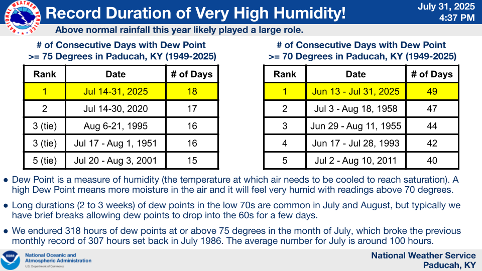
As we moved into the summer season, a significant flash flooding event occurred on the northwest side of Evansville, IN on the afternoon of June 13th. Well above normal rainfall during the first half of the year likely was a key contributor in our record high humidity levels observed during the summer. Several locations including Paducah observed a record number of days with dewpoints reaching 70 and 75 degrees. One of our longest lasting heat waves on record struck from July 16-30, with heat index readings routinely in the 100 to 110 range and even localized values up to 120 were observed on a few days. After a very wet first half of the year, the faucet turned off in August and September which resulted in severe drought developing across much of the region.
There were a total of 61 tornadoes that touched down across our area in 2025, which was the 2nd most on record for a year only behind the 79 in 2011. The tornadoes covered a total of 574.5 miles, which shattered the previous record for most number of miles of tornado damage in a year (previously 449.8 miles in 2011). There were 9 EF-3's, which was the most strong tornadoes in a single year since 1957 (when there were 12). The vast majority of them (47) occurred during 3 events: March 14-15, April 2, and May 16.
|
Review of top weather events in 2025 (in chronological order). CLICK ON IMAGES TO ENLARGE |
|||||
|
1. January 5 - Significant winter storm with snow and ice. Over 100K customers without power at its peak.
Image: Map showing observed ice accumulations from this event |
2. February 15-16 - Widespread flooding across the state of Kentucky, results in major rises on numerous rivers.
Image: Map showing observed rainfall amounts at Kentucky Mesonet stations for February 15-16. |
||||
|
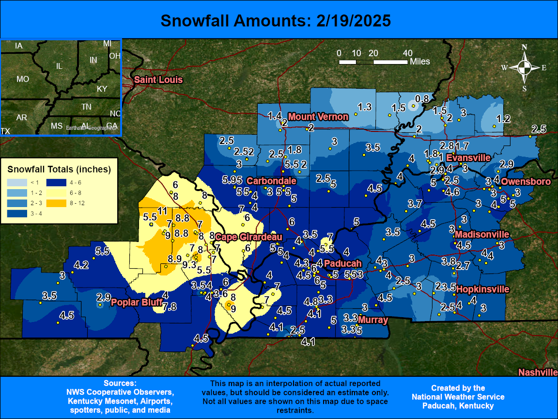
3. February 18-19 - Snowstorm with widespread 3-8" across our region. Portions of I-57 and I-24 are briefly shutdown overnight due to accidents.
. Image: Map showing observed snowfall amounts from this event |
4. March 14-15 - Historic severe thunderstorm event produces 14 tornadoes on the night of the 14th into early on the 15th. Six of these tornadoes were EF-3's.
Image: Map showing all the tornado tracks from this event |
||||
|
5. April 2 - Historic tornado outbreak produces 23 tornadoes, breaking the record for a single event in NWS Paducah history.
Image: Map showing all the tornado tracks from this event |
6. April 2025 - Significant flash flooding with amounts ranging from 6 to 16" from April 2-6. Moderate to major river flooding follows.
Image: MRMS Rainfall Totals from April 2-6 |
||||
|
7. May 16 - Significant severe thunderstorm event which produced 10 tornadoes and very large hail of at least tennis ball to softball size.
Image: Map showing all the tornado tracks from this event |
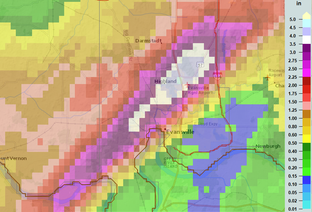
8. June 13 - Major flash flooding strikes the westside of Evansville, IN.
Image: MRMS Rainfall totals from June 13th |
||||
|
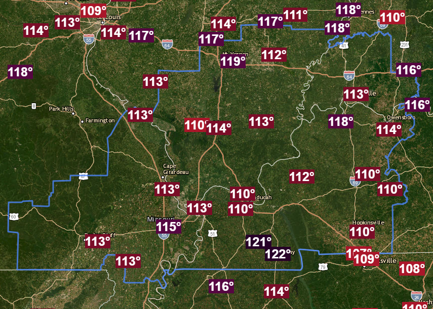
9. July 16-30 - One of our longest lasting heat waves on record with heat index readings peaking between 110 and 122 degrees.
Image: Map showing observed peak heat index readings on July 28th (one of the worst days of this prolonged heat wave) |
10. Summer 2025 - Record high humidity levels were observed.
|
||||