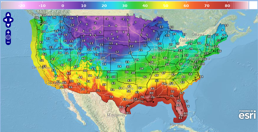
National Weather Service United States Department of Commerce

Severe Thunderstorms and Heavy Rainfall From the Southern High Plains into the Lower Mississippi Valley

Strong to severe thunderstorms capable of producing large hail, gusty winds and heavy rainfall will be possible over the next few days from New Mexico to Texas, into western Mississippi. Additional heavy rainfall over previously saturated soils may lead to flash and urban flooding. Isolated thunderstorms will also be possible across portions of the Midwest. Read More >

Click a location below for detailed forecast.

Last Map Update: Sun, May. 12, 2024 at 2:46:34 am MDT

National Weather Service Missoula, MTNational Weather Service Great Falls, MTNational Weather Service Billings, MT
National Weather Service Boise, IDZoom
Out

National Weather Service Western and Central Wyoming
National Weather Service Elko, NVNational Weather Service Salt Lake City, UTNational Weather Service Grand Junction, CO

Do you have an interest in the weather and helping your community? We are excited to announce that we will be conducting 2 virtual SKYWARN Spotter Training classes this spring! These classes are free and open to the public of all ages. Both sessions will be identical...pick the one that works best for you! The link to join (at class time) is https://meet.goto.com/skywarn. Please share these training opportunities widely with anyone you know who might be interested in joining the SKYWARN program!


Text Product Selector (Selected product opens in current window)