.png)
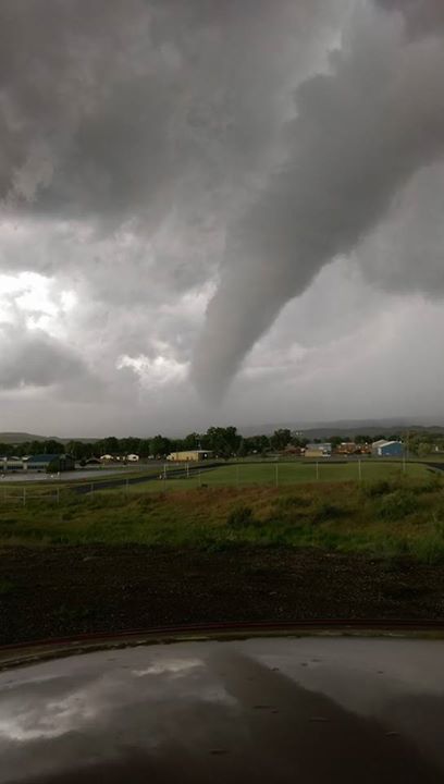
Kaycee Tornado Photo Courtesy of Mark Malli - June 12, 2017.
NWS Riverton will conduct a special routine weekly test of the NOAA Weather Radio broadcast, which will serve as the tornado drill. This will take place around 9:00 A.M. MDT on Wednesday, May 12, 2021. The drill is designed to train emergency services organizations and educate people how to respond to a tornado warning. Communities may sound local warning sirens and many schools will conduct safety drills for their students.
You should use the special routine weekly NOAA Weather Radio test as your tornado drill and it is encouraged that you treat this like a real event so that you can test your safety plan. It is also encouraged that you further become familiar with safety rules and make plans to protect yourself and your family when storms develop. If an actual tornado warning was issued, it means a tornado has been sighted or indicated on radar and people should take shelter immediately. Tornado warnings are disseminated through NOAA weather radio, local television and radio stations, cable television systems, and outdoor warning sirens.
Tornado Safety Information
|
Outdoors: If possible, seek shelter in a sturdy building. If not, lie flat and face-down on low ground, preferably in a ditch or coulee, protecting the back of your head with your arms. Get as far away from trees and cars as you can as they may be blown onto you in a tornado or from high winds.
Indoors: Go to the lowest floor, small center room (like a bathroom or closet), under a stairwell, or in an interior hallway with no windows. Crouch as low as possible to the floor, facing down; and cover your head with your hands or something soft like a mattress.
Vehicle: Vehicles are extremely dangerous in a tornado. If possible, get out of the car as quickly as possible and seek shelter in a sturdy building. If in the open country, run to low ground away from any cars (which may roll over on you). Lie flat and face-down, protecting the back of your head with your arms. Avoid seeking shelter under bridges, which can create deadly traffic hazards while offering little protection against flying debris.
|
Bighorn County, WY Tornado - June 12 2017. - June 12 2017. |
Though Wyoming does not see nearly as many tornadoes as the plain states, commonly referred to as Tornado Alley, the Cowboy state does see its fair share. The majority of Wyoming tornadoes touch down in the southeastern corner of the state. However the strongest tornado to the hit the state was an F4 in Teton County. The Tornado swept through Yellowstone National Park and was 2550 yards wide and on the ground for 24 miles at elevations ranging from 8,500-10,000’. This makes it the highest altitude violent tornado in the United States. Luckily, there were no deaths caused by this tornado due to its remote location. Even though Wyoming is the least populated state, that is unfortunately not always the case.
F2 and stronger Western and Central Wyoming Tornadoes:
- June 3, 1958 - F2 - Big Horn County. -Shell- Only 17 yards wide with a 0.2 mile path.
- June 26, 1959 - F2 - Bighorn County. 1 dead 0 injured A man was killed when the tornado uprooted a tree, and crushed his pickup truck. In an area between Trapper Canyon and Bruce Mountain.
- June 11, 1962 - F2 - Natrona County north of Casper, south of Edgerton, ending near Wright.
- June 12, 1962 - F2 - Big Horn Couny In Burlington.
- June 16, 1962 - F3 - Fremont County just north of Lander.
- July 9th, 1962 - F2 Big Horn County west of Basin.
- June 26, 1964 - F2 - Park County. In Powell.
- June 6, 1967 - F2 - Fremont County north of Riverton.
- July 24, 1967 - F2 - Big Horn County west of Basin.
- May 29, 1971 - F2 - Natrona County just northeast of Casper. Tiny, but mighty. 10 yards wide with a 0.2 mile path.
- August 27, 1973 - F2 - Fremont County near Atlantic City.
- July 4, 1878 - F2 - Big Horn County just east of Greybull.
- July 11, 1978 - F2 - Park County near Powell.
- July 20, 1978 - F2 - Natrona County north of Casper
- August 2, 1985 - F3 - Big Horn County, east of Lovell. Tiny, but mighty. 10 yards wide with a 0.2 mile path.
- June 7, 1986 - F2 - Fremont County -Shoshoni-
- June 18, 1987 - F2 - Natrona County North of Casper.
- July 21, 1987 - F4 -The Yellowstone, the strongest tornado ever recorded in Wyoming.
- July 21, 1987 - F2 - Natrona County northwest of Casper.
- July 10, 2001 - F2 - Hot Springs County northwest of Kirby. 50 yards wide with a path only 0.5 miles long.
- Kaycee Tornado, rated an EF2, on June 12th, 2017. No injuries or deaths were reported. A tornadic storm developed around 5:00 pm over SW Johnson County, near Barnum. 1” to 1.75” hail was reported near Barnum by 5:15 pm, increasing to 2.5” by 5:30pm 5 miles SW of Kaycee. This storm then proceeded to produce multiple vortices, as it neared Kaycee and Mayoworth. Reports of tornadoes came in between 5:35 and 5:50 pm, as the storm slowly moved to the NNE. At its widest, the tornado produced damage approximately 250 yards across along its 1.71 mile path.
- June 6, 2018 - EF2 - Washakie County East of Ten Sleep. 300 yards wide with a 0.98 mile path. This tornado snapped around 1,000 trees and the storm also produced large hail.
- June 6, 2018 - EF2 - Johnson County northwest of Mayoworth. 300 yards wide with a 1.03 mile path. This tornado also snapped nearly a thousand trees and the storm produced large hail.
Also across the state in 2018 - 2020:
- May 27, 2018 - EF2 - Laramie County -Federal-
- June 1, 2018 - EF3 - Campbell County -Gillette-
- June 6, 2018 - EF3 - Albany County -Howell-
- July 28, 2018 - EF3 - Converse County -Douglas-
- September 10, 2019 - EF2 - Goshen County - Fort Laramie and Lingle area
- July 6, 2020 - EF2 - Crook County - Sundance
Watch vs. Warning & What to do
Tornado watches are issued when conditions look favorable for tornado formation. The Storm Prediction Center is responsible for issuing tornado watches which typically cover numerous counties. If a tornado watch is issued for your area, stay informed of the weather through: NOAA Weather Radio, TV, Radio, Internet, &/or Social Media. This way you will know if a tornado warning is issued for your area and whether you need to take cover immediate or when the danger has passed.
Tornado warnings are issued when a tornado has been sighted or has been indicated by radar. Your local NWS office issues Tornado Warnings. If a tornado warning is issued for your location there is an imminent danger to life and property and you should get into your basement, storm shelter, or to an interior room on the lowest floor of a sturdy building.
NOAA Weather Radio All-Hazards - Popular Features
|
Tone Alarm: Severe weather watches and warnings are broadcast with a tone alarm. The tone will activate all the weather radio receivers which are equipped to receive it, even if the audio is turned off. This is especially useful for warnings which occur during the night when most people are asleep.
SAME: Specific Area Message Encoding (SAME) allows a user to specify the particular area for which you wish to receive alerts. This minimizes the number of "false alarms" for events which might not be impacting your area.
Selectable Alerting of Events: Some receivers allow a user to turn off the alarm for certain events which might not be important to you.
Battery Backup: Since power outages often occur during storms, having a receiver with battery backup can be crucial.
External Antenna Jack: While most receivers come with a whip antenna which can usually be extended out from the unit, a user may need an external antenna to get a good reception. Some receivers come with an external antenna jack (normally in the back of the unit) which will allow a user to connect to a larger antenna (indoors or outdoors).
Strobe Light: A strobe light accessory provides a visual alert. It's ideal for the hearing-impaired and for use in noisy production environments like metal working facilities to alert personnel of a warning.
|


|
Other Sources
Internet: The National Weather Service's webpage at https://weather.gov allows you a fast and easy look at where the hazards are occurring for the current day. To find out information for your local area, just click on the map in your general area.
Broadcast TV and Radio Stations: Most local radio and television stations across the state automatically receive hazardous watches and warnings and help disseminate that information over the air. They have local knowledge and want to be able to provide their viewers and listeners with the best information they can.
Wireless / Cell Phone technologies: Many cell phone providers are including an option of getting warnings on your cell phone through text messaging or other means. Check with your provider to see if they offer a service like this. There are also some NWS programs that allow you to get alerts on your mobile device. For more information about the NWS wireless emergency alerts initiative, go to: https://www.weather.gov/wrn/wea
Weather Radio Sites Across Wyoming

Additional Information
NWS Weather Radio Home Page
Storm Ready
Storm Spotter's Guide
Some of the pages listed are in a PDF format. To view these files Download Adobe Reader
Thunderstorms, Tornadoes and Lightning: Natures Most Violent Storms
Red Cross: Disaster Safety
|


.permission%20In%20Kaycee.jpg)


