
Wildfire smoke will push into the Midwest, worsening air quality. A frontal system brings severe storms from the Northern Plains to the Mid‑Atlantic the next few days. Heavy Gulf Coast rain is possible as Tropical Depression Two has formed, while monsoonal storms persist in the Southwest with heavy rainfall. Hazardous heat expands from the Plains into the Lower Mississippi Valley. Read More >
Summary | Forecast | Observed Precip Amounts | Travel Center | Monitoring & Reporting | Safety
SYNOPSIS: Occasional heavy rainfall, especially west of the Continental Divide, will result in an increased potential for flooding across portions of Park, Teton, Hot Springs and Fremont counties. A Flood Watch is in effect until Midnight Monday Night for these areas. Locations east of the Continental Divide will receive lesser amounts of rainfall from this system. Please stay tuned for further updates regarding this developing flood potential across central and western Wyoming through the middle of the upcoming week.
 |
 |
|
Click Image To Enlarge |
Click Image To Enlarge |
Summary | Forecast | Observed Precip Amounts | Travel Center | Monitoring & Reporting | Safety
|
|
|
| Road Conditions and Web Cameras | |||
 |
|||
|
|
|
|
|
 |
 |
 |
 |
|
|
|
|
|
 |
|
 |
 |
|
|
|
|
|
 |
 |
 |
 |
|
|
|
|
|
 |
 |
 |
 |
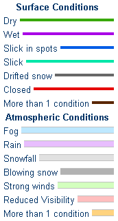
If you plan to travel, we recommend checking road conditions along your route and staying on top of road closures here. If you are on Twitter, follow the hashtag: #WyoRoad (or look below) for the latest weather affecting roads and road conditions in and around Wyoming.
| Tweets by @NWSRiverton | #WyoRoad Tweets |
|
Get the play-by-play on this storm and contribute your own snow reports to #wywx |
On the road? Tweet road conditions to #WyoRoad!
|

Summary | Forecast | Observed Precip Reports | Travel Center | Monitoring & Reporting | Safety
 |
Monitor our Weather Summary Page for current Warnings, Watches, and Advisories. What's the difference? |
 |
Check the latest Weather Story graphic for an overview of the area forecast. |
 |
Check out what's on the radar. Riverton | Pocatello | Cheyenne | Billings | Salt Lake City | Rapid City | Mosaic |
| Submit storm reports/images and keep up to date with us on Facebook! | |
 |
Submit storm reports/images and keep up to date with us on Twitter! |
 |
Other reporting methods include email (nws.riverton@noaa.gov), or by phone at 1-800-211-1448. |
 |
Check the latest Public Information Statement for the latest storm reports. |
| Monitor current road conditions by visiting the Wyoming Dept. of Transportation (WYDOT) or by calling 5-1-1. | |
| Get current road conditions, web camera images, road alerts, and much more on your mobile device by downloading the Wyoming 511 Mobile App. |
Summary | Forecast | Observed Snow and Wind | Travel Center | Monitoring & Reporting | Safety
 |
Learn more about the National Weather Service's efforts to build a Weather-Ready Nation! |


