National Weather Service United States Department of Commerce

Thunderstorms and Heavy Rains Across Portions of the Central and Eastern US; Heat Expands to Portions of the East and West

Widespread showers and thunderstorms, some severe, may produce heavy downpours and flash flooding across much of the eastern and central U.S. Dangerous heat will continue in the Pacific Northwest and expand across portions of the East. Deep tropical moisture and associated thunderstorms will bring heavy rainfall and localized flash flooding across portions of Florida into the central Gulf Coast. Read More >

Summary | Forecast | Observed Snow and Wind | Travel Center | Monitoring & Reporting | Safety


SYNOPSIS:

A strong weather system will continue to impact the area today through the day Friday with significant snow and wind.  Snow levels are at, or will lower to valley floors across western Wyoming over the next few hours as a cold front begins to pull through the area.  Strong to high wind, rain showers and thunderstorms along with falling temperatures are expected east of the Continental Divide, and across Sweetwater County this afternoon.  Rain in the lower elevations east of the Divide, are expected to change over to snow late this afternoon or evening.  Snow and strong wind will continue tonight into the day Friday across much of the area east of the Divide with the most impacts occurring across northern Wyoming.  Near blizzard conditions are possible across Johnson County late Thursday night and Friday.

IMPACTS:

  • Slick & snow covered roads.
  • Road closures are possible especially across northern Johnson County Thursday night and Friday.
  • Strong winds at times will create a risk for a blow over for light-weight or high-profile vehicles.
     

Top Menu


 Summary | Forecast | Observed Snow and WindTravel Center | Monitoring & Reporting | Safety
 

NWS Text Products and Forecasts

  Area Forecast Discussion
  Winter Weather Statement
  Special Weather Statement
  What's a "Watch?"
  Observed Snow Totals or High Wind
 High Wind Statement
 Weather Story

Quick View of Hazards and Forecast Snow Totals (created at 11:30 AM on 4/12)
Click to enlarge Click to enlarge

Click Image To Enlarge
Winter Storm Warning in effect for Northwestern WY

Winter Weather Advisories are in effect in western & north central WY

High Wind Warning in effect in portions of southern and central WY

Click Image To Enlarge
Forecast Snowfall
for Thursday and Friday


Snow and Wind Forecasts

Click to enlarge Click to enlarge

Today's Snowfall Forecast
Click Image To Enlarge

Today's Peak Wind Gusts
Click Image To Enlarge

Click to enlarge Click to enlarge

Day 2 Snowfall Forecast
Click Image To Enlarge

Day 2 Peak Wind Gusts
Click Image To Enlarge

Click to enlarge Click to enlarge

Day 3 Snowfall Forecast
Click Image To Enlarge

Day 3 Peak Wind Gusts
Click Image To Enlarge

 Top Menu


Snow Totals and Wind Reports will be posted and updated here once the storm occurs
(Please double check date and time of product)

                        
647
NOUS45 KRIW 161820
PNSRIW
WYZ001>020-022>030-170620-

Public Information Statement
National Weather Service Riverton WY
1220 PM MDT Wed Jul 16 2025

...Widespread Rainfall Tuesday afternoon and evening...

A cold front, combined with a strong mositure surge, brout widespread
showers and thunderstorms to much of Wyoming on Tuesday. Nearly
everyone got some rainfall with the exception of portions of south-
west WY. Some locations that saw training thunderstorms received over
one inch of rain, while others were only skirted by thunderstorms and
received minimal rainfall. A selection of rainfall reports are
below.

...PRECIPITATION REPORTS...

Location                     Amount    Time/Date       Elevation (ft.)

...Big Horn County...
Lovell 0.5 ESE               0.62 in   0723 AM 07/16   3829
Lovell 0.7 S                 0.55 in   0800 AM 07/16   3906
Lovell                       0.51 in   0700 AM 07/16   3848
Deaver                       0.39 in   0800 AM 07/16   4105
Cowley 0.3 NNE               0.29 in   0722 AM 07/16   4016
Lovell 2.2 S                 0.29 in   0800 AM 07/16   3928
Byron 2.9 WSW                0.25 in   0700 AM 07/16
Greybull 12.9 ENE            0.21 in   0600 AM 07/16   4169

...Fremont County...
Lander 9.1 NNW               1.15 in   0640 AM 07/16   5509
Fort Washakie 3.7 SE         0.49 in   0600 AM 07/16   5548
Hudson 0.1 NNE               0.37 in   0700 AM 07/16   5108
Lander 2NNW                  0.31 in   0700 AM 07/16   5352
Dubois                       0.28 in   0600 AM 07/16   6955
Shoshoni 13 NW               0.24 in   0800 AM 07/16   4760
5 ESE Dubois                 0.19 in   0800 AM 07/16
Pavillion 5.8 E              0.11 in   0700 AM 07/16   5322
Lander 7WNW                  0.06 in   0630 AM 07/16   6042
Lander 5.9 SSE               0.06 in   0700 AM 07/16   5556
Lander 5.1 SW                0.06 in   0700 AM 07/16   5980
Riverton 5.4 W               0.06 in   0800 AM 07/16
Riverton 2.2 WSW             0.04 in   0800 AM 07/16   5033
Riverton 1.9 W               0.04 in   0800 AM 07/16   5123
Riverton 2 W                 0.03 in   0700 AM 07/16   5073
Riverton                     0.03 in   0700 AM 07/16   4955

...Hot Springs County...
Thermopolis 33.2 W           0.51 in   0700 AM 07/16
Kirby                        0.36 in   0800 AM 07/16   4352
Thermopolis 6 NNE            0.30 in   0700 AM 07/16   4434
Thermopolis 18.6 E           0.25 in   0800 AM 07/16   4879
Thermopolis 9NE              0.15 in   0700 AM 07/16   4282

...Johnson County...
Kaycee - Coop                0.34 in   0700 AM 07/16   4660
Buffalo 2NE                  0.33 in   0800 AM 07/16   4770
Buffalo 0.6 E                0.30 in   0700 AM 07/16   4696
Buffalo 13 SSE               0.30 in   0700 AM 07/16   4819
Buffalo 4 SSW                0.28 in   0700 AM 07/16   5262
Kaycee 17 NNW                0.27 in   0700 AM 07/16   5056
Buffalo 4.0 N                0.25 in   0600 AM 07/16   4685
Kaycee 10.9 WNW              0.16 in   0700 AM 07/16   5481
Kaycee 14.6 W                0.15 in   0700 AM 07/16
Kaycee 5.2 NNW               0.15 in   0700 AM 07/16

...Lincoln County...
Smoot 5 SSE                  0.13 in   0700 AM 07/16   7005
Bedford 1.8 S                 T in     0700 AM 07/16   6302
Star Valley Ranch 1.0 S       T in     0700 AM 07/16   6204
Afton                         T in     0800 AM 07/16   6248
Star Valley Ranch             T in     0800 AM 07/16   6253

...Natrona County...
Casper 5 SSW                 1.06 in   0700 AM 07/16   6262
Casper 1S                    0.93 in   0700 AM 07/16   5522
Casper 0.7 WSW               0.71 in   0700 AM 07/16
Casper 1.7 W                 0.68 in   0700 AM 07/16   5146
Casper 1.5 SW                0.58 in   0600 AM 07/16
Casper 1.2 E                 0.57 in   0800 AM 07/16
Casper 2.8 ENE               0.54 in   0800 AM 07/16   5202
Casper 0.7 NE                0.52 in   0700 AM 07/16   5179
Casper 2 SW                  0.48 in   0800 AM 07/16   5434
Casper 2.0 ENE               0.46 in   0600 AM 07/16   5252
Casper 7.5 W                 0.36 in   0630 AM 07/16   5361
Casper 7.1 SW                0.28 in   0530 AM 07/16   5415
Lysite 12 NE                 0.20 in   0700 AM 07/16   6045

...Park County...
Meeteetse 2.0 SE             0.31 in   0700 AM 07/16   6071
Meeteetse 0.2 NE             0.20 in   0700 AM 07/16   5807
Powell 4 ENE                 0.19 in   0630 AM 07/16   4288
Cody 5.3 E                   0.19 in   0700 AM 07/16
Clark 3NE                    0.19 in   0800 AM 07/16   4117
Powell 24.2 WNW              0.19 in   0800 AM 07/16
Cody 2.9 ESE                 0.18 in   0700 AM 07/16
Cody 2NE                     0.18 in   0700 AM 07/16   4939
Cody 1SE                     0.18 in   0700 AM 07/16   5102
Powell 0.2 ESE               0.16 in   0730 AM 07/16   4392
Cody 20.9 W                  0.14 in   0600 AM 07/16   5815
Powell 5E                    0.14 in   0700 AM 07/16   4276
Cody 2WSW                    0.12 in   0700 AM 07/16   5161
6 SW Ralston                 0.12 in   0700 AM 07/16
Cody 7NE                     0.12 in   0700 AM 07/16   4787
Cody 7.2 NNE                 0.10 in   0500 AM 07/16   4859
Powell 4.0 WSW               0.10 in   0630 AM 07/16
Tower Falls                  0.09 in   0800 AM 07/16   6275

...Sublette County...
Pinedale 26 NNW              0.17 in   0800 AM 07/16   7687
Cora 14.2 N                  0.16 in   0700 AM 07/16   7740
Pinedale 14 NW               0.03 in   0600 AM 07/16   7464
Boulder Rearing Station       T in     0800 AM 07/16   6940

...Sweetwater County...
Green River 1 SSE             T in     0630 AM 07/16   6241
Green River 0.5 NNW           T in     0700 AM 07/16   6185

...Teton County...
Jackson 12 NE                0.63 in   0809 AM 07/16   6663
Jackson 5 NW                 0.57 in   0700 AM 07/16   6217
Jackson 7.8 N                0.50 in   0715 AM 07/16
Jackson 0.3 ENE              0.49 in   0700 AM 07/16   6264
Wilson 1.0 SE                0.45 in   0700 AM 07/16   6155
Teton Village 2 NE           0.44 in   0600 AM 07/16   6339
Wilson 3 SSW                 0.29 in   0800 AM 07/16   7010
Grant Village 0.8 E          0.14 in   0700 AM 07/16   7807
Bechler Ranger Station       0.12 in   0730 AM 07/16   6432

...Washakie County...
Ten Sleep                    0.42 in   0700 AM 07/16   4426
Winchester                   0.33 in   0700 AM 07/16   4216
Ten Sleep 27 S               0.23 in   0800 AM 07/16   5002
Worland 8 SW                 0.20 in   0600 AM 07/16   4136
Worland 2 NE                 0.17 in   0700 AM 07/16   4089
Worland - COOP               0.16 in   0700 AM 07/16   4058
Worland 2.3 NE               0.15 in   0700 AM 07/16
Worland 1 W                  0.15 in   0800 AM 07/16   4052
Ten Sleep 5 NNW              0.11 in   0700 AM 07/16   4531
Worland 9.6 N                0.04 in   0700 AM 07/16   4043

Observations are collected from a variety of sources with varying
equipment and exposures. We thank all volunteer weather observers
for their dedication. Not all data listed are considered official.

$$


 Top Menu


Summary | Forecast | Observed Snow and WindTravel Center | Monitoring & Reporting | Safety

Current Radar & Web Cams - Click Thumbnails To Enlarge
Northern Rockies Radar
Riverton Radar
Pocatello
Billings
Salt Lake
Cheyenne


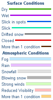
            Road Conditions and Web Cameras
Teton Pass - Hwy 22
Alpine Junction - U.S. Hwy 26/89/191
Jackson
Togwotee Mountain Lodge
Togwotee Pass - U.S. Hwy 26
Dubois
Granite Pass - U.S. Hwy 14
Powder River Pass - U.S. Hwy 16
South Pass - Hwy 28
Cody
Buffalo - I-25/I-90 Interchange
Casper Mountain
Casper
Beaver Rim - U.S. Hwy 287
I-80 - Rock Springs
I-80  - Laramie


                                                                       Click Here to See All Webcams                                                  

If you plan to travel, we recommend checking road conditions along your route and staying on top of road closures here. If you are on Twitter, follow the hashtag: #WyoRoad (or look below) for the latest weather affecting roads and road conditions in and around Wyoming. 


Get the play-by-play on this storm and contribute your own snow reports to #wywx

Follow Us on Twitter @NWSRiverton

On the road?

Tweet road conditions to #WyoRoad!


 Summary | Forecast | Observed Snow and WindTravel Center | Monitoring & Reporting | Safety

PLEASE SEND US YOUR SNOW REPORTS (CLICK HERE)

Monitor our Weather Summary Page for current Warnings, Watches, and Advisories. What's the difference?
Current            Weather Story Check the latest Weather Story graphic for an overview of the area forecast.
NWS Riverton Radar Check out what's on the radar.
Riverton | Pocatello | Cheyenne | Billings | Salt Lake City | Rapid City | Mosaic
Submit storm reports/images and keep up to date with us on Facebook!
Submit storm reports/images and keep up to date with us on Twitter!
Other reporting methods include email (nws.riverton@noaa.gov), or by phone at 1-800-211-1448.
Check the latest Public Information Statement for the latest storm reports.
WyDoT's Webpage Monitor current road conditions by visiting the Wyoming Dept. of Transportation (WYDOT) or by calling 5-1-1.
Get current road conditions, web camera images, road alerts, and much more on your mobile device by downloading the Wyoming 511 Mobile App.


Top Menu

 Summary | Forecast | Observed Snow and WindTravel Center | Monitoring & Reporting | Safety


Winter Safety Kit      |      Winter Weather Safety


Learn more about the National Weather Service's efforts to build a Weather-Ready Nation!


 Top Menu