Extreme heat will continue in the interior Northwest into midweek before finally waning. Hot temperatures, dry, gusty winds, and isolated dry thunderstorms will bring critical fire weather. Heavy rain and thunderstorms are expected across portions of the Great Basin, Rockies, and central/southern Plains. An atmospheric river will bring heavy rain and strong winds to southwest Alaska. Read More >
Summary | Travel Center | Snowfall Reports | Monitoring & Reporting | Safety
A spring storm brought another round of significant rain and snow to portions of the Cowboy State. Significant snow fell from Sweetwater County northeast across SE Fremont and Natrona Counties into southern Johnson County. Casper received 6 to 10 inches of snow while Rock Springs got 4 to 8 inches. The eastern slopes of the southern third of the Wind River Mountains picked up another 1 to 2 feet of snow.
Summary | Travel Center | Snowfall Reports | Monitoring & Reporting | Safety
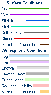
Latest WYDOT Road Information Map
 |
|
|
|
|
|
|
|
|
|
 |
 |
 |
 |
|
|
|
|
|
 |
 |
 |
 |
|
|
|
|
|
|
|
 |
 |
 |
If you plan to travel, we recommend checking road conditions along your route and staying on top of road closures here. If you are on Twitter, follow the hashtag: #WyoRoad (or look below) for the latest weather affecting roads and road conditions in and around Wyoming.
| Tweets by @NWSRiverton | #WyoRoad Tweets |
|
Get the play-by-play on this storm and contribute your own snow reports to #wywx |
On the road? Tweet road conditions to #WyoRoad!
|
| Preliminary Snowfall Totals as of 12 PM Wednesday, April 27, 2016 | |||||
|---|---|---|---|---|---|
PUBLIC INFORMATION STATEMENT
NATIONAL WEATHER SERVICE RIVERTON WY
0231 PM MDT WED APR 27 2016


...EXPECTED FINAL SNOWFALL REPORTS FROM MONDAY AFTERNOON THROUGH
TODAY...WEDNESDAY MORNING...

ANOTHER UPPER LEVEL DISTURBANCE BROUGHT A SECOND ROUND OF
PRECIPITATION...MAINLY FALLING AS SNOW...ACROSS THE REGION. THE
SNOWFALL REPORTS FROM THIS SYSTEM CAN BE FOUND BELOW.

IN ADDITION THERE WERE THREE DAILY PRECIPITATION RECORDS AND TWO
DAILY SNOWFALL RECORDS SET FOR APRIL 26TH. THEY WERE AS FOLLOWS...

CASPER SET A DAILY PRECIPITATION RECORD WHEN 1.18 INCHES FELL ON
APRIL 26TH...BREAKING THE PREVIOUS RECORD OF 0.47 INCHES SET IN
2015.

CASPER ALSO SET A DAILY SNOWFALL RECORD WHEN 9.9 INCHES FELL ON
APRIL 26TH...BREAKING THE PREVIOUS RECORD OF 7.5 INCHES SET IN 1984.

RIVERTON AIRPORT SET A DAILY PRECIPITATION RECORD WHEN 0.79 INCHES
FELL ON APRIL 26TH...BREAKING THE PREVIOUS RECORD OF 0.31 INCHES
LAST SET IN 2015. NOTE THE RIVERTON AIRPORT RECORDS ONLY DATE BACK
TO 1995.

RIVERTON AIRPORT ALSO SET A DAILY SNOWFALL RECORD WHEN 3.6 INCHES
FELL ON APRIL 26TH...BREAKING THE PREVIOUS RECORD OF 2.2 INCHES LAST
SET IN 2011. NOTE THESE RECORDS ALSO ONLY DATE BACK TO 1995.

LANDER SET A PRECIPITATION RECORD WHEN 1.25 INCHES FELL ON APRIL
26TH BREAKING THE PREVIOUS RECORD OF 1.05 INCHES...LAST SET IN 1984.


LOCATION                             SNOWFALL

BIG HORN COUNTY...
 SHELL CREEK SNOTEL...                6 INCHES.
 BONE SPRINGS DIVIDE SNOTEL...        5 INCHES.
 BALD MOUNTAIN SNOTEL...              2 INCHES.

FREMONT COUNTY...
 TOWNSEND CREEK SNOTEL...            19 INCHES.
 9.5 SW LANDER...                    18 INCHES.
 HOBBS PARK SNOTEL...                18 INCHES.
 DEER PARK SNOTEL...                 16 INCHES.
 SOUTH PASS SNOTEL...                16 INCHES.
 6.6 SW LANDER...                    14 INCHES.
 JEFFREY CITY...                     12 INCHES.
 ST. LAWRENCE ALT SNOTEL...          11 INCHES.
 6 SW LANDER...                    10.8 INCHES.
 ATLANTIC CITY...                   9.7 INCHES.
 26 SSE RIVERTON...                   8 INCHES.
 9 SSE LANDER...                    7.8 INCHES.
 COLD SPRINGS SNOTEL...               7 INCHES.
 RIVERTON AIRPORT...                5.9 INCHES.
 SWEETWATER STATION...                5 INCHES.
 RIVERTON...                        4.6 INCHES.
 BROOKS LAKE...                       4 INCHES.
 6 N RIVERTON...                    3.5 INCHES.
 LANDER AIRPORT...                  3.4 INCHES.
 9 NW RIVERTON...                     3 INCHES.
 LANDER...                          1-3 INCHES.
 2 W RIVERTON...                    2.5 INCHES.
 BURROUGHS CREEK SNOTEL...            2 INCHES.
 1 SE LANDER...                       2 INCHES.
 DUBOIS...                            1 INCH.

HOT SPRINGS COUNTY...
 OWL CREEK SNOTEL...                  6 INCHES.
 THERMOPOLIS...                     3.5 INCHES.
 9 NE THERMOPOLIS...                2.8 INCHES.

JOHNSON COUNTY...
 BEAR TRAP MEADOW SNOTEL...           7 INCHES.
 LITTLE GOOSE SNOTEL...               6 INCHES.
 HANSEN SAWMILL SNOTEL...             6 INCHES.
 SOLDIER PARK SNOTEL...               5 INCHES.
 3 NNE KAYCEE...                    4.9 INCHES.
 CLOUD PEAK RESERVOIR SNOTEL...       4 INCHES.
 7 NE BUFFALO...                    3.5 INCHES.
 17 E KAYCEE...                     3.5 INCHES.
 BUFFALO...                         1.4 INCHES.
 KAYCEE...                            1 INCH.
 17 NNW KAYCEE...                   0.2 INCHES.

LINCOLN COUNTY...
 COMMISSARY RIDGE...                  3 INCHES.
 SALT RIVER SUMMIT SNOTEL...          3 INCHES.
 SPRING CREEK DIVIDE SNOTEL...        2 INCHES.
 5 SSE SMOOT...                       1 INCH.
 INDIAN CREEK SNOTEL...               1 INCH.
 BLIND BULL SUMMIT...               0.1 INCHES.

NATRONA COUNTY...
 CASPER MOUNTAIN...                  20 INCHES.
 1 SW CASPER...                    12.5 INCHES.
 CASPER MOUNTAIN...                  12 INCHES.
 RENO HILL SNOTEL...                 11 INCHES.
 10 WSW CASPER...                  10.5 INCHES.
 1 S CASPER...                     10.3 INCHES.
 CASPER AIRPORT...                 10.1 INCHES.
 CASPER MOUNTAIN SNOTEL...           10 INCHES.
 BESSEMER BEND...                    10 INCHES.
 5 SSW CASPER...                    9.5 INCHES.
 POWDER RIVER...                      9 INCHES.
 GRAVE SPRING SNOTEL...               8 INCHES.
 3 WSW CASPER...                    7.9 INCHES.
 1 SW CASPER...                     7.8 INCHES.
 2 S CASPER...                        7 INCHES.
 4 WSW CASPER...                    6.8 INCHES.
 CASPER...                        3-6.2 INCHES.
 4 W CASPER...                      5.5 INCHES.
 2 S CASPER...                        5 INCHES.
 1 S CASPER...                        5 INCHES.
 2 E EVANSVILLE...                    4 INCHES.
 MILLS...                             3 INCHES.
 MIDWEST...                     1.5-2.5 INCHES.

PARK COUNTY...
 KIRWIN SNOTEL...                     3 INCHES.
 MARQUETTE SNOTEL...                  3 INCHES.
 TIMBER CREEK SNOTEL...               2 INCHES.
 BLACKWATER SNOTEL...                 2 INCHES.
 3 NE SUNSHINE...                   1.1 INCHES.
 BEARTOOTH LAKE SNOTEL...             1 INCH.
 2 WSW CODY...                        1 INCH.
 4 SE CODY...                       0.9 INCHES.
 CODY...                            0.8 INCHES.
 5 ESE CODY...                      0.5 INCHES.
 26 SW CODY...                      0.2 INCHES.

SUBLETTE COUNTY...
 POCKET CREEK SNOTEL...               8 INCHES.
 LARSEN CREEK SNOTEL...               7 INCHES.
 BOULDER REARING STATION...           3 INCHES.
 BIG SANDY OPENING SNOTEL...          3 INCHES.
 SNIDER BASIN SNOTEL...               2 INCHES.
 LOOMIS PARK SNOTEL...                2 INCHES.
 ELKHART PARK G.S. SNOTEL...          2 INCHES.
 NEW FORK LAKE SNOTEL...              2 INCHES.
 GUNSITE PASS SNOTEL...               2 INCHES.
 PINEDALE...                        1.8 INCHES.

SWEETWATER COUNTY...
 7 SE ROCK SPRINGS...                15 INCHES.
 ROCK SPRINGS...                  4-7.5 INCHES.
 FARSON...                            6 INCHES.
 GREEN RIVER...                   3.7-6 INCHES.
 4 NNW ROCK SPRINGS...              4.1 INCHES.
 5 N FARSON...                        4 INCHES.

TETON COUNTY...
 TOGWOTEE MOUNTAIN LODGE...           4 INCHES.
 TOGWOTEE PASS SNOTEL...              3 INCHES.
 GRAND TARGHEE - CHIEF JOSEPH...      2 INCHES.
 GROS VENTRE SUMMIT SNOTEL...         2 INCHES.
 GRAND TARGHEE SNOTEL...              2 INCHES.
 JACKSON HOLE - RENDEZVOUS BOWL...    1 INCH.
 GRASSY LAKE SNOTEL...                1 INCH.
 JACKSON HOLE - RAYMER...           0.1 INCHES.

WASHAKIE COUNTY...
 MIDDLE POWDER SNOTEL...             13 INCHES.
 POWDER RIVER PASS SNOTEL...          5 INCHES.
 27 S TEN SLEEP...                  2.2 INCHES.
 16 SSE TEN SLEEP...                  1 INCH.
 5 NNW TEN SLEEP...                 0.4 INCHES.

YELLOWSTONE NATIONAL PARK...
 LEWIS LAKE DIVIDE SNOTEL...          2 INCHES.
 CANYON SNOTEL...                     1 INCH.

$$
|
Summary | Travel Center | Snowfall Reports | Monitoring & Reporting | Safety
PLEASE SEND US YOUR SNOW REPORTS (CLICK HERE)
 |
Monitor our Severe Weather Summary Page for current Warnings, Watches, and Advisories. What's the difference? |
 |
Check the latest Weather Story graphic for an overview of the area forecast. |
 |
Check out what's on the radar. Riverton | Pocatello | Cheyenne | Billings | Salt Lake City | Rapid City | Mosaic |
 |
Submit storm reports/images and keep up to date with us on Facebook! |
 |
Submit storm reports/images and keep up to date with us on Twitter! |
 |
Other reporting methods include submitting an online report, email (cr.wxriw@noaa.gov), or by phone at 1-800-211-1448. |
 |
Check the latest Public Information Statement for the latest storm reports. |
 |
Monitor current road conditions by visiting the Wyoming Dept. of Transportation (WYDOT) or by calling 5-1-1. |
Summary | Forecast | Travel Center | Monitoring & Reporting | Safety

Winter Safety Kit | Winter Weather Safety
 |
Learn more about the National Weather Service's efforts to build a Weather-Ready Nation! |