National Weather Service United States Department of Commerce

Severe Thunderstorm and Heavy Rainfall Potential Continues

A low pressure center tracking across the Great Lakes and its associated cold front extending across the Southern Plains will focus occasional showers and thunderstorms through tonight. A few of these thunderstorms may become severe alongside heavy rainfall that may cause flash flooding; Portions of the Southern Plains would be the greatest threat for these hazards through tonight. Read More >

Summary | Forecast | Observed Snow and Wind | Travel Center | Monitoring & Reporting | Safety


SYNOPSIS:

Saturday & Saturday evening:  A stronger, but warmer system is expected to impact the Cowboy State. The bulk of the precipitation is expected to impact the western and southern portions of the area. Significant mountain snow/valley rain could occur over the west and southwest with this system with rain expected up to 9000 feet.  A few thunderstorms are possible Saturday afternoon and evening which could produce heavy downpours. The rainfall in the western valleys on a melting snowpack, and some frozen ground could cause localized flooding across the western valleys Saturday.  Although the heaviest of the precipitation will end Saturday night, the localized flooding threat could continue over the far west into the day Sunday.

IMPACTS:

  • Localized flooding possible across the western Valleys Saturday & Sunday


Top Menu


 Summary | Forecast | Observed Snow and WindTravel Center | Monitoring & Reporting | Safety
 

NWS Text Products and Forecasts

  Area Forecast Discussion
  Flood Watch Statement
  Special Weather Statement
  What's a "Watch?"
  Observed Snow Totals
 
 Weather Story

Quick View of Hazards and Forecast Precipitation Totals (created at 6 AM on 4/7)
Click to enlarge Click to enlarge

Click Image To Enlarge
â–º Flood Advisory for the Jackson Hole Valley
until 1145 AM Sunday

â–º Flood Watch for the Star Valley
from Noon Saturday through Sunday Afternoon

Click Image To Enlarge
Expected Precipitation
Saturday & Saturday Night
(Mainly Rainfall below 9000 feet)

 Top Menu


Snow Totals and Wind Reports will be posted and updated here once the storm occurs
(Please double check date and time of product)

                        
322
NOUS45 KRIW 290424
PNSRIW
WYZ001>020-022>030-291609-

Public Information Statement
National Weather Service Riverton WY
1009 PM MDT Mon Apr 28 2025

...STORM SUMMARY...

A large Spring-Time weather system slowly pushed through Wyoming
from Sunday through Monday evening. This weather system had plenty
of moisture in it and these rain totals certainly prove that true.
Lower elevations had all rain with this weather system, while most
of the mountains had mostly snow. The totals below are rain totals
and liquid equivalent totals from snowfall. Generally elevations
above 7000 ft saw most of this precipitation as snow and below
7000 ft as rain.

...PRECIPITATION REPORTS...

Location                     Amount    Time/Date       Elevation (ft.)

...Wyoming...

...Big Horn County...
Bald Mtn.                    1.10 in   0900 PM 04/28   9379
Lovell 12E                   1.00 in   0915 PM 04/28   3660
Bone Springs Div             0.80 in   0900 PM 04/28   9350
Hyattville 5 ENE             0.73 in   0952 PM 04/28   5669
Lovell 0.5 ESE               0.40 in   1146 AM 04/28   3829
Byron                        0.34 in   0955 PM 04/28   4022
Lovell                       0.33 in   1000 PM 04/28   3964
Greybull 30 E                0.30 in   0858 PM 04/28   8897
Greybull Airport             0.18 in   0953 PM 04/28   3917
Willow Creek                 0.08 in   0949 PM 04/28   4299

...Fremont County...
Castle Creek                 0.70 in   0800 PM 04/28   8399
Lander 6 SW                  0.63 in   0915 PM 04/28   6555
RED CANYON RANCH NC LANDER 1 0.46 in   0910 PM 04/28   5777
Burroughs Creek              0.40 in   0800 PM 04/28   8750
Lander 7 NW                  0.31 in   0955 PM 04/28   5797
Lander Airport               0.28 in   0953 PM 04/28   5565
Kinnear                      0.28 in   1000 PM 04/28   5413
Riverton                     0.17 in   0950 PM 04/28   5390
Riverton Airport             0.15 in   0953 PM 04/28   5509
Kinnear                      0.15 in   0959 PM 04/28   5488
Hudson 3 NNW                 0.14 in   0946 PM 04/28   5555
South Pass City 8 W          0.12 in   0950 PM 04/28   8120
Dubois 19 WSW                0.11 in   0910 PM 04/28   8833
Riverton - CWC               0.10 in   1000 PM 04/28   5372
RIVERTON                     0.08 in   1000 PM 04/28   4920
1 W Riverton                 0.07 in   1000 PM 04/28   4989
Riverton                     0.06 in   0945 PM 04/28   4966
Shf5 Portable                0.05 in   0908 PM 04/28   8645
Crowheart                    0.05 in   0945 PM 04/28   6137
Elkhorn                      0.03 in   0857 PM 04/28   8084
Muddy Gap 7 SW               0.01 in   0950 PM 04/28   7379

...Hot Springs County...
Thermopolis                  0.96 in   0955 PM 04/28   4425
Meeteetse 10 S               0.33 in   0942 PM 04/28   7126
Shf2 - Portable              0.28 in   0902 PM 04/28   8560
Kirby                        0.21 in   1000 PM 04/28   4350
Anchor Dam                   0.17 in   0930 PM 04/28   6250

...Johnson County...
Cloud Peak Reservoir         1.10 in   0800 PM 04/28   9859
Story 4 SE                   0.95 in   0945 PM 04/28   4662
Bear Trap Meadow             0.90 in   0900 PM 04/28   8200
Buffalo                      0.55 in   0945 PM 04/28   4370
BUFFALO                      0.50 in   0930 PM 04/28   4675
Buffalo Airport              0.44 in   0953 PM 04/28   4905
Buffalo 18 NW                0.28 in   0947 PM 04/28   8604
Story 8 S                    0.21 in   0915 PM 04/28   5278
Barnum 7 SW                  0.19 in   0946 PM 04/28   6439
Buffalo 15 W                 0.17 in   0915 PM 04/28   8398

...Lincoln County...
Salt River Summit Snotel     0.50 in   0900 PM 04/28   7760
Indian Creek Snotel          0.40 in   0900 PM 04/28   9424
Etna                         0.32 in   0945 PM 04/28   5692
Kelley R.S. Snotel           0.30 in   0900 PM 04/28   8180
Thayne                       0.24 in   0945 PM 04/28   5948
Afton                        0.21 in   0956 PM 04/28   6257
Blind Bull Summit            0.20 in   0900 PM 04/28   8649
Afton  0.6 NW (AGRIMET)      0.14 in   0900 PM 04/28   6210
Afton                        0.14 in   1000 PM 04/28   6267
B-T Portable No. 1           0.11 in   0951 PM 04/28   7385
Cottonwood Creek             0.10 in   0900 PM 04/28   7669
Cokeville 15 NE              0.06 in   0900 PM 04/28   8470
Calpet 15 SW                 0.01 in   0945 PM 04/28   6957

...Natrona County...
Reno Hill Snotel             0.50 in   0900 PM 04/28   8399
Casper Mtn.                  0.50 in   0900 PM 04/28   7899
Casper 8 S                   0.33 in   0952 PM 04/28   7740
Casper Airport               0.23 in   0953 PM 04/28   5327
Bar Nunn                     0.19 in   0959 PM 04/28   5275
Casper                       0.13 in   0945 PM 04/28   5341
Hiland 16 S                  0.10 in   0910 PM 04/28   6379

...Park County...
Fort Collins                 1.86 in   1000 PM 04/28   5102
Cody Airport                 1.83 in   0956 PM 04/28   5138
POWELL                       0.85 in   0958 PM 04/28   4381
Clark                        0.84 in   1000 PM 04/28   4270
Wapiti                       0.73 in   0955 PM 04/28   5993
Powell                       0.68 in   1000 PM 04/28   4386
Meeteetse                    0.66 in   0945 PM 04/28   5749
Cody 10 WNW                  0.64 in   0940 PM 04/28   8400
Cody 15 SE                   0.63 in   0946 PM 04/28   5520
Sylvan Road Snotel           0.60 in   0900 PM 04/28   7120
Sylvan Pass 14 S - YNP       0.57 in   0908 PM 04/28   8649
Crandall                     0.48 in   0912 PM 04/28   6640
Pahaska 3 E                  0.39 in   0857 PM 04/28   7500
Mammoth 15 WSW               0.38 in   0949 PM 04/28   7899
Canyon 1 SW - YNP            0.33 in   0949 PM 04/28   7899
Shf1 - Fts Qd                0.18 in   0856 PM 04/28   5924
Pahaska                      0.07 in   0900 PM 04/28   6798

...Sublette County...
Snider Basin Snotel          0.50 in   0900 PM 04/28   8060
East Rim Divide Snotel       0.50 in   0900 PM 04/28   7930
Big Sandy Opening            0.40 in   0900 PM 04/28   9080
Kendall R.S.                 0.30 in   0900 PM 04/28   7740
Big Piney 21 W               0.18 in   0909 PM 04/28   8200
Triple Peak Snotel           0.10 in   0900 PM 04/28   8500
Bondurant                    0.07 in   0900 PM 04/28   6648
Pinedale 7 NE                0.04 in   0926 PM 04/28   8529
Big Piney Airport             T  in    0953 PM 04/28   6944


...Sweetwater County...
Rock Springs                 0.07 in   0959 PM 04/28   6432
Rock Springs 15 SE           0.04 in   0944 PM 04/28   7549
Rock Springs Airport         0.03 in   0954 PM 04/28   6745

...Teton County...
Two Ocean Plateau Snotel     1.30 in   0900 PM 04/28   9240
Base Camp                    0.90 in   0900 PM 04/28   7029
Moran Jct 7 E                0.84 in   0952 PM 04/28   7250
Grassy Lake                  0.80 in   0800 PM 04/28   7265
Moran                        0.76 in   0945 PM 04/28   6748
Grand Targhee Snotel         0.70 in   0900 PM 04/28   9260
ALTA                         0.66 in   0955 PM 04/28
South Entrance 19 W - YNP    0.63 in   0949 PM 04/28   6399
Gros Ventre Summit           0.60 in   0900 PM 04/28   8750                 Alta
Alta 17 N                    0.55 in   0903 PM 04/28   6830
South Entrance 3 W - YNP     0.40 in   0945 PM 04/28   7040
South Entrance - YNP         0.36 in   0945 PM 04/28   6898
Alta                         0.31 in   0945 PM 04/28   6430
B-T Portable No. 3           0.28 in   0855 PM 04/28   6000
Jackson Dam                  0.28 in   0945 PM 04/28   6776
Jackson Hole - Rendezvous Bo 0.25 in   0945 PM 04/28   9634
Milepost 12 Snow Study Plot  0.24 in   0900 PM 04/28   8007
Lake Yellowstone - YNP       0.23 in   0900 PM 04/28   7875
Jackson                      0.23 in   1000 PM 04/28   6158
Jackson Hole - Raymer (BTAVA 0.22 in   0945 PM 04/28   9657
Moose 4 N                    0.16 in   0858 PM 04/28   6729
Jackson Hole - Mid Mtn (BTAV 0.16 in   0945 PM 04/28   8225
Jackson Hole - Base (BTAVAL) 0.16 in   0945 PM 04/28   6611
Hoback                       0.14 in   0954 PM 04/28   5928
South Entrance 5 SSW - YNP   0.10 in   0945 PM 04/28   7020
Jackson                      0.05 in   0945 PM 04/28   6240
Jackson Hole Airport         0.03 in   0956 PM 04/28   6453
Old Faithful - YNP           0.01 in   0915 PM 04/28   7319

...Washakie County...
Worland 10 SSE               1.07 in   0917 PM 04/28   4520
Ten Sleep 2 SE               0.73 in   0930 PM 04/28   4418
Ten Sleep 12 ENE             0.52 in   0914 PM 04/28   8202
Big Trails 15 SSW            0.48 in   0940 PM 04/28   6554
Worland                      0.36 in   1000 PM 04/28   4400
Worland 1 NE                 0.28 in   1000 PM 04/28   4064
Worland Airport              0.19 in   0953 PM 04/28   4190

Observations are collected from a variety of sources with varying
equipment and exposures. We thank all volunteer weather observers
for their dedication. Not all data listed are considered official.

$$


 Top Menu


Summary | Forecast | Observed Snow and WindTravel Center | Monitoring & Reporting | Safety

Current Radar & Web Cams - Click Thumbnails To Enlarge
Northern Rockies Radar
Riverton Radar
Pocatello
Billings
Salt Lake
Cheyenne


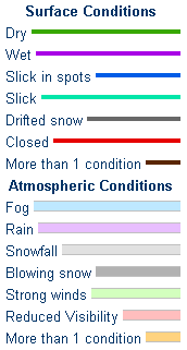
            Road Conditions and Web Cameras
Teton Pass - Hwy 22
Alpine Junction - U.S. Hwy 26/89/191
Jackson
Togwotee Mountain Lodge
Togwotee Pass - U.S. Hwy 26
Dubois
Granite Pass - U.S. Hwy 14
Powder River Pass - U.S. Hwy 16
South Pass - Hwy 28
Cody
Buffalo - I-25/I-90 Interchange
Casper Mountain
Casper
Beaver Rim - U.S. Hwy 287
I-80 - Rock Springs
I-80  - Laramie


                                                                       Click Here to See All Webcams                                                  

If you plan to travel, we recommend checking road conditions along your route and staying on top of road closures here. If you are on Twitter, follow the hashtag: #WyoRoad (or look below) for the latest weather affecting roads and road conditions in and around Wyoming. 


Get the play-by-play on this storm and contribute your own snow reports to #wywx

Follow Us on Twitter @NWSRiverton

On the road?

Tweet road conditions to #WyoRoad!


 Summary | Forecast | Observed Snow and WindTravel Center | Monitoring & Reporting | Safety

PLEASE SEND US YOUR SNOW REPORTS (CLICK HERE)

Monitor our Weather Summary Page for current Warnings, Watches, and Advisories. What's the difference?
Current            Weather Story Check the latest Weather Story graphic for an overview of the area forecast.
NWS Riverton Radar Check out what's on the radar.
Riverton | Pocatello | Cheyenne | Billings | Salt Lake City | Rapid City | Mosaic
Submit storm reports/images and keep up to date with us on Facebook!
Submit storm reports/images and keep up to date with us on Twitter!
Other reporting methods include email (nws.riverton@noaa.gov), or by phone at 1-800-211-1448.
Check the latest Public Information Statement for the latest storm reports.
WyDoT's Webpage Monitor current road conditions by visiting the Wyoming Dept. of Transportation (WYDOT) or by calling 5-1-1.
Get current road conditions, web camera images, road alerts, and much more on your mobile device by downloading the Wyoming 511 Mobile App.


Top Menu

 Summary | Forecast | Observed Snow and WindTravel Center | Monitoring & Reporting | Safety


Winter Safety Kit      |      Winter Weather Safety


Learn more about the National Weather Service's efforts to build a Weather-Ready Nation!


 Top Menu