In Alaska, a powerful storm will bring dangerous seas, blizzard conditions, strong winds and bitterly cold across the state through mid-week. Meanwhile, Pacific storm will move inland across California with lower elevation rain and accumulating mountain snow; Strong winds will affect the central Great Basin. A clipper system to bring snow and gusty winds for the Northeast corridor into Wednesday. Read More >
|
Wyoming Winter Weather Awareness Day October 12, 2016
The National Weather Service (NWS) offices serving Wyoming and local emergency management agencies are recognizing 2016 Winter Weather Awareness Day on Wednesday, October 12. The National Weather Service Offices in Wyoming encourage you to become familiar with safety rules and make plans to protect yourself, your family, students and employees when winter storms strike. Winter storm warnings are disseminated through NOAA All-Hazards Weather Radio, local television and radio stations, cable television systems and on the Internet at various sites including weather.gov. This information describes the different types of severe winter weather we have in Wyoming and provides safety information related to each type. Click on one of the tabs above to learn more. Snow falls frequently across Wyoming from October through May, with snow beginning as early as late September across the lower elevations. About five times a year on the average, stations at the lower elevations will have snowfall exceeding five inches. Accumulations of 10 to 15 inches or more for a single storm occur but are infrequent outside of the mountains. Wind will frequently accompany or follow a snowstorm and pile the snow into drifts several feet deep. The snow sometimes drifts so much that it is difficult to obtain an accurate measurement of snowfall. High winds, low temperatures, and moderate to heavy snow/blowing snow cause blizzard or near blizzard conditions. These conditions sometimes last a day or two, but it is uncommon for a severe blizzard to last over three days. The snowiest months vary widely across the state (see table below). Generally the spring months of March and April are favored east of the Continental Divide. For Cheyenne, Casper, Rawlins, Douglas, Riverton, and Lander, the snowiest months strongly trend toward March and April. Several of these locations benefit from upslope flow enhanced by surrounding terrain (e.g., Casper Mountain south of Casper, or the Wind River Mountains southwest of Lander). March is the snowiest month in Buffalo, Cody, and Torrington, although these locations generally have a more evenly distributed monthly average snowfall between about December and April. Communities in the northeast part of the state (Sheridan, Gillette, Sundance, and Hulett) also see a more even monthly distribution of snow throughout the winter. Conditions are very similar at Rock Springs and Worland where large snowfalls are rare; therefore, the average monthly snowfall changes little through the winter. Table of Monthly and Seasonal Snowfall Averages for select cities in Wyoming. Snowfall is in inches.
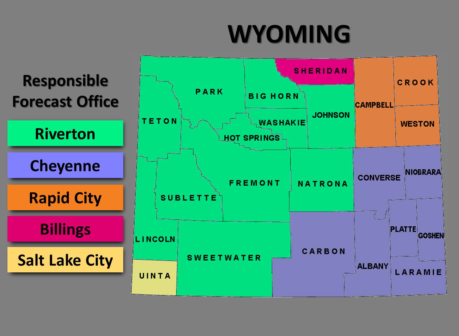
Things are a little different west of the Divide in communities such as Jackson, Afton, Evanston, and Pinedale where the snow falls heaviest in mid-winter, from December through early March. Persistent westerly flow off the Pacific Ocean during those months is largely responsible for the snow in the western valleys. This westerly flow warms and dries as it moves down the eastern slopes of the Divide leading to drier conditions in an effect commonly referred to as a "precipitation shadow." Wyoming is served by five National Weather Service offices. We issue watches and warnings for the protection of life and property. Below is an image of which NWS offices cover what counties in the state:  For additional information, contact your local NWS office:
|