
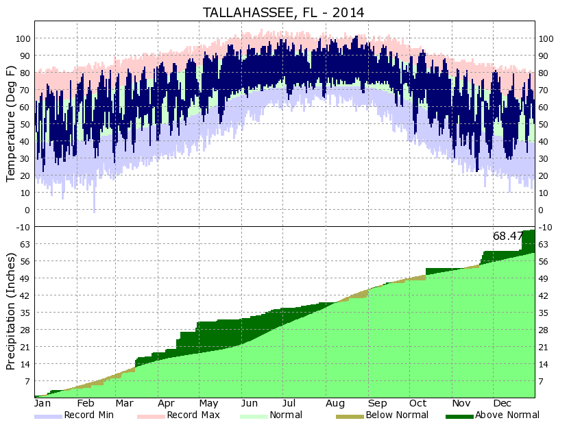
In general, 2014 across the area saw a dry, warm summer bookended by a wetter-than-normal start and end to the year. Abundant rainfall and several significant flooding events early in the year left soil moisture and groundwater levels across the area well above normal by May. In fact, a USGS observing site near Greenhead, Florida measured record groundwater levels as of May 15, 2014. Tallahassee receives approximately 38% of its normal annual rainfall in the summer months, but this summer ended up being quite dry across much of the area leading to a general reprieve from flooding. Many days in October to December ended up being dry, but several short-lived, significant rainfall events led to above normal rainfall for the last three months of the year. A chart showing daily observed temperatures and rainfall for Tallahassee during 2014 is included below.
Tallahassee, Florida Climate Summary
Notable 2014 Weather Stories From Around the Area
This is a collection of some significant weather stories in 2014 from our local area. This is not a comprehensive list, but reflects several of the weather events from the past year.
1. Cold end to January and the January 28-29 Winter Storm — (Event webpage)
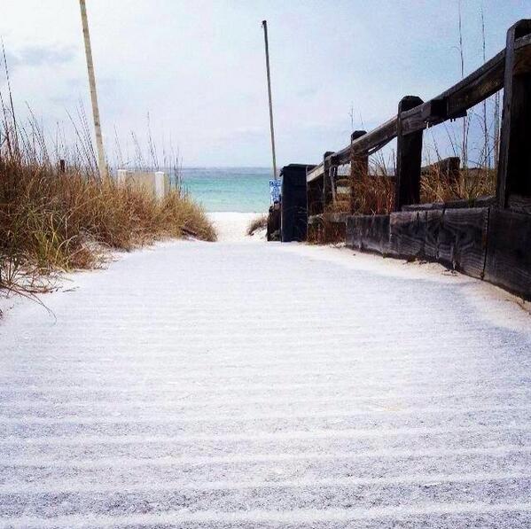 At the Tallahassee Airport, 15 of the last 17 days in January recorded a below normal average temperature. 11 of those same 17 days had freezes. Overall, the average temperature in Tallahassee in January was 3.1 degrees below normal. In the last few days of January, a significant winter storm affected the Southeast and eastern Gulf coast. This was the same winter storm that produced significant traffic incidents in Atlanta, Georgia and Birmingham, Alabama due to a combination of cold temperatures and snowfall. According to the NWS Birmingham webpage, the Alabama State Troopers responded to 731 vehicle accidents across the state of Alabama around the time of this winter storm (January 28-31). The NWS Atlanta webpage states that the Georgia State Patrol responded to over 1500 winter storm related accidents in Georgia. In our area, more significant snow, sleet, and freezing rain accumulations tended to occur over the northwest — parts of the western Florida Panhandle, southeast Alabama, and west-central Georgia. The predominant precipitation type across the area was sleet and freezing rain, although around an inch of snow accumulated in some parts of southeast Alabama. Some sleet even accumulated down to the beaches from Destin to Panama City Beach, coating the boardwalks and sand. At one point, over 200 miles of Interstate 10 were closed in the Florida Panhandle due to icy bridges. Some freezing rain and sleet was observed in the Tallahassee area. Although Tallahassee mainly saw trace amounts, there was enough sleet in a few cases to build a small "sleetman".
2. A Wet February to April with Several Flooding Episodes — (Event page for April 7th) (Event page for April 29-30)
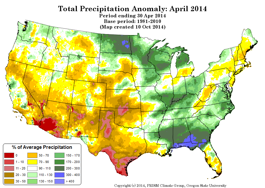
February and March were the beginning of a wet period across the area, but April in particular saw rainfall significantly above normal for much of the region. Rainfall totals across the area in April were generally 250-400% of normal. This led to several flooding episodes across the area, with both significant flash flooding and river flooding. A heavy rain and severe weather event on April 29-30th produced significant flash flooding in the western Florida Panhandle including around Panama City. That was the same event that also led to extreme rain rates in Pensacola, with 5.68" of rain being observed in one hour between 9 PM and 10 PM CDT on April 29th. Several rivers reached moderate or major flood stage during these months as well. The average streamflow on many area rivers in April 2014 was above the 90th percentile for the month. The above graphic is courtesy of PRISM / Oregon State University, and it shows the percent of normal precipitation for the United States in April 2014.
3. Significant Drying in the Summer Months
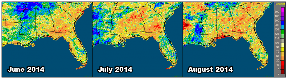
The very wet start to the year was immediately followed by a significant dry period. Tallahassee recorded four consecutive months of below normal rainfall from May through August, and the summer months (June, July, and August) were collectively the driest on record. The June-August period saw only 8.99" of rainfall at Tallahassee, which was over a foot below normal (-13.26"). By the beginning of September, drought had developed across parts of the area despite the very high soil moisture just several months earlier. The above graphic shows the percent of normal precipitation for the Southeast US during the summer months of 2014.
4. August 21st to 24th Heat Wave
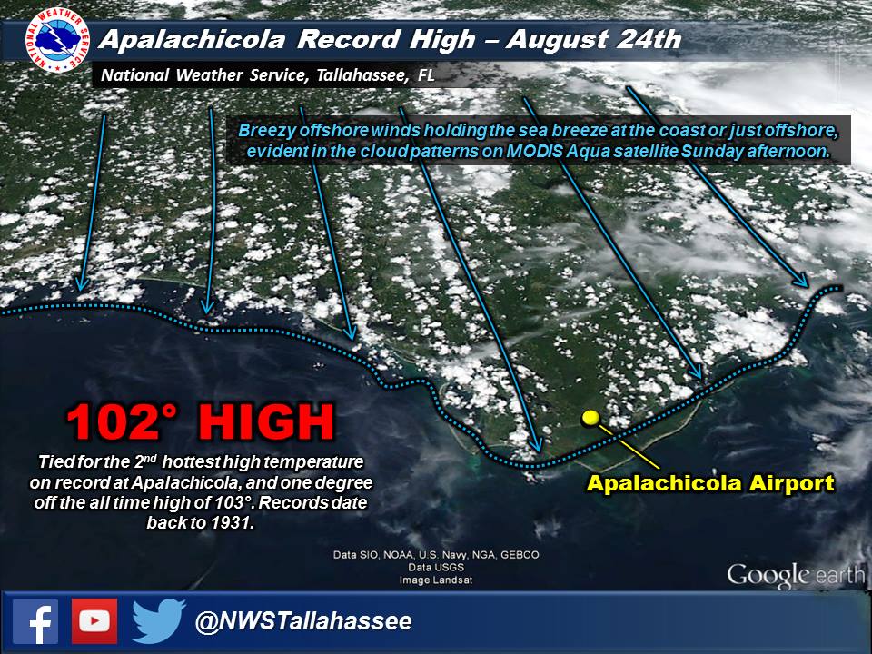 From August 21st to 24th, a heat wave built across parts of the eastern Gulf coast. Hot temperatures combined with dewpoints in the 70s to around 80 degrees to produce dangerous heat index readings. The maximum heat index readings generally ranged between 105°F and 115°F. Tallahassee had four consecutive days of record highs from August 21-24, with 99°F on the 21st, 100°F on the 22nd, and 101°F on the 23rd and 24th. On the 24th, breezy northwesterly winds managed to pin the sea-breeze just offshore, and Apalachicola had their second hottest temperature on record, 102°F. It is normally difficult to get that sort of heat all the way to the shores of the Gulf.
Usually during a heat wave, a strong upper level ridge is present which tends to lead to weak winds through the depth of the atmosphere. This was the case during our August heat wave and was evidenced by the fact that our radiosonde (attached to a weather balloon) on the morning of the 20th ended up landing back on the FSU baseball fields less than a mile from where it was launched from our office!
5. November 17th Long-Track EF2 Tornado in Blountstown, FL — (Event webpage)
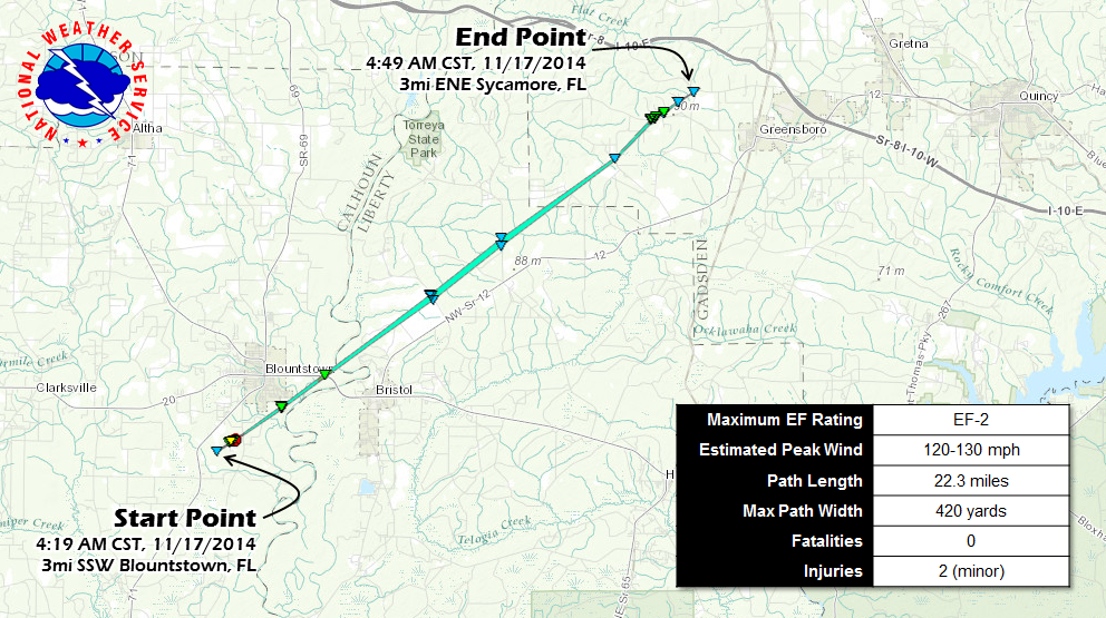
Severe weather, including a few tornadoes, impacted the forecast area. Most of the severe weather occurred in the Florida Panhandle and Southwest GA. There were three confirmed tornadoes. One of those was a long-track tornado that reached EF2 intensity near Blountstown, FL and stayed on the ground longer than any tornado in Florida since February 2007. It was also only the third significant tornado to occur in the local forecast area since March 2007. The fourth was to follow just 5 weeks later (see item 7 below).
6. December 23rd Heavy Rainfall and Flooding — (Event webpage)
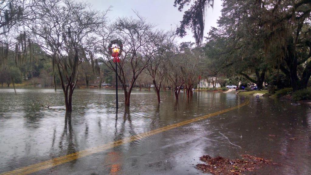
A significant rainfall event on December 23rd produced widespread rainfall totals in excess of 3 inches across the area, with some locations receiving nearly 10 inches of rain. One band of heavy rainfall was situated right over the city of Tallahassee, which produced flash flooding in parts of the city with numerous road closures, vehicles stalled in water, and some water rescues. The Tallahassee Airport measured 7.44" of rain on the 23rd, which made it Tallahassee's wettest December day on record, and 9th wettest calendar day on record overall. The above picture of flooding from Lake Ella in Tallahassee, by Max Tsaparis via Twitter.
7. EF2 Tornado in Valdosta, GA on December 29th — (Event webpage)
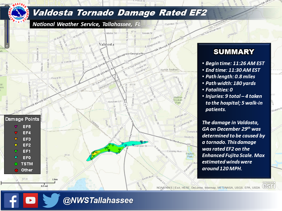 A band of light to moderate rain was moving across the area on December 29th in association with a surface cold front. Along the leading edge of the area of rain, a shallow, "mini-supercell" developed and moved into Lowndes County, Georgia. No lightning was observed with the cell; the tops of the showers were generally below 15,000 feet. As the cell moved over Valdosta, a brief tornado spun up and produced damage up to EF2 intensity on the south side of Valdosta. This was the first tornado to directly affect the city of Valdosta since 1997.
This was an unusual case as atmospheric conditions were not very favorable, though not totally prohibitive, for significant tornadoes. Limited atmospheric instability reduced the overall intensity of showers, despite the one that tracked through Lowndes County, and most of the area just saw a few hours of steady, light to moderate rain.

