HOME
FORECAST
Local
Graphical
Aviation
Marine
Rivers and Lakes
Hurricanes
Severe Weather
Fire Weather
Sunrise/Sunset
Long Range Forecasts
Climate Prediction
Space Weather
PAST WEATHER
Past Weather
Astronomical Data
Certified Weather Data
SAFETY
INFORMATION
Wireless Emergency Alerts
Weather-Ready Nation
Brochures
Cooperative Observers
Daily Briefing
Damage/Fatality/Injury Statistics
Forecast Models
GIS Data Portal
NOAA Weather Radio
Publications
SKYWARN Storm Spotters
StormReady
TsunamiReady
Service Change Notices
EDUCATION
NEWS
SEARCH
Search For
NWS
All NOAA
ABOUT
About NWS
Organization
For NWS Employees
National Centers
Careers
Contact Us
Glossary
Social Media
NWS Transformation
Local forecast by
"City, St" or ZIP code
Sorry, the location you searched for was not found. Please try another search.
Multiple locations were found. Please select one of the following:
Location Help
News Headlines
Tropical Storm Bertha 2026 Preliminary Post Tropical Cyclone Report Available - click "Observational data summary" 🌀📋
Are you PREPARED for Hurricane Season? 🌀
🏖️ Heading to the Gulf Beaches? Learn about rip current safety! 🌊
Extreme Drought Improved Some This Week, but Still Lingers in the Southeast Florida Big Bend. Click Here for the Latest
Customize Your
Weather.gov
Enter Your City, ST or ZIP Code
Remember Me
LOADING...
Tallahassee, FL
Weather Forecast Office
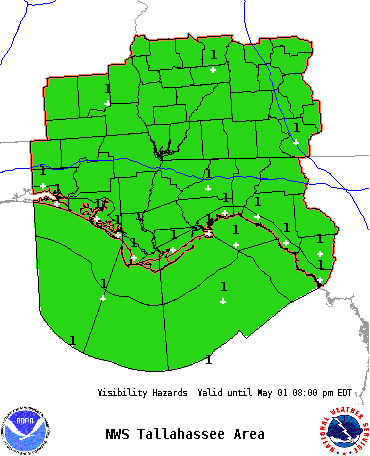
Graphical Hazardous Weather Outlook - Visibility
Weather.gov
>
Tallahassee, FL
> Graphical Hazardous Weather Outlook - Visibility
Current Hazards
Submit a Storm Report
Graphical Hazardous Weather Outlook
Outlooks
Rip Current Risk
Local Storm Reports (Text)
Local Storm Reports (Map)
Current Conditions
Observed Precipitation
Satellite
Surface Observations
Observations (Text Format)
Marine Observations
TLH Upper Air Sounding
Radar
Local KEOX Standard Radar - Fort Rucker (low bandwidth)
Local KEOX Enhanced Radar - Fort Rucker
Local KEVX Standard Radar - Eglin AFB (low bandwidth)
Local KEVX Enhanced Radar - Eglin AFB
Local KTLH Standard Radar - Tallahassee (low bandwidth)
Local KTLH Enhanced Radar - Tallahassee
Local KVAX Standard Radar - Valdosta (low bandwidth)
Local KVAX Enhanced Radar - Valdosta
Regional Standard Radar (low bandwidth)
Forecasts
Forecaster's Discussion
Probabilistic Precipitation
Fire
Hourly View
Tropical
Marine
Winter Weather (Experimental)
Aviation
Rivers and Lakes
*New* National Water Prediction Service (NWPS)
*New* NWPS - Local View
Hydrology
Climate and Past Weather
Climate Prediction
Drought
Local Climate Data and Studies
Climate Graphs
Local Past Weather Events
Weather History
Tropical Cyclone Reports
Local Programs
Cooperative Observer Program
Education/Outreach
Newsletter
NOAA Weather Radio
Research
SKYWARN
Social Media Dashboard
Student Volunteer Program
Weather Ready Nation
Weather Impact Levels
Lightning
Tornado
Prevailing Wind
TS wind and/or Hail
Inland
Flood
Coastal
Flood
Surf & Rip Current
Waves
Visibility
Heat/Cold
Visibility Hazard
Resources
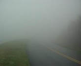
About Fog
Legend
None
No visibilities below 1/4 mile.
Slight
Patchy (1-20% coverage) visibilities < 1/4 mile in fog
or < 1 mile in heavy rain
Moderate
Areas (30-50% coverage) of visibility < 1/4 mile.
High
Widespread (60-80% coverage) visibilities < 1/4 mile.
Extreme
Total (>80% coverage) visibilities < 1/4 mile.
Weather Forecasts
|
Past Weather
|
Tropical Weather
Follow us on X
Follow us on Facebook
Follow us on YouTube
TAE RSS Feed