| Annual - 2011 |
- 75 tornados occurred in 2011 across eastern OK and northwest AR, breaking the record for the highest annual number of tornadoes in the NWS Tulsa forecast area. The previous record annual number of tornadoes in this area was 53, in both 1999 and 2008.
|
- In Tulsa, 26.1" of snow has fallen so far this year, which ties with 1924 as 2nd snowiest year on record. The current record is 29.6" in 1958.
|
- In Fort Smith, the average annual temperature for 2011 is 64.4, making it the 2nd warmest year on record. The current record is 64.5°F in 1938 (records began in 1883).
|
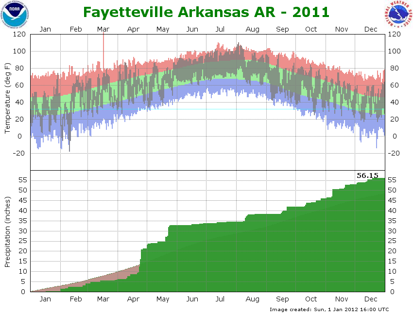
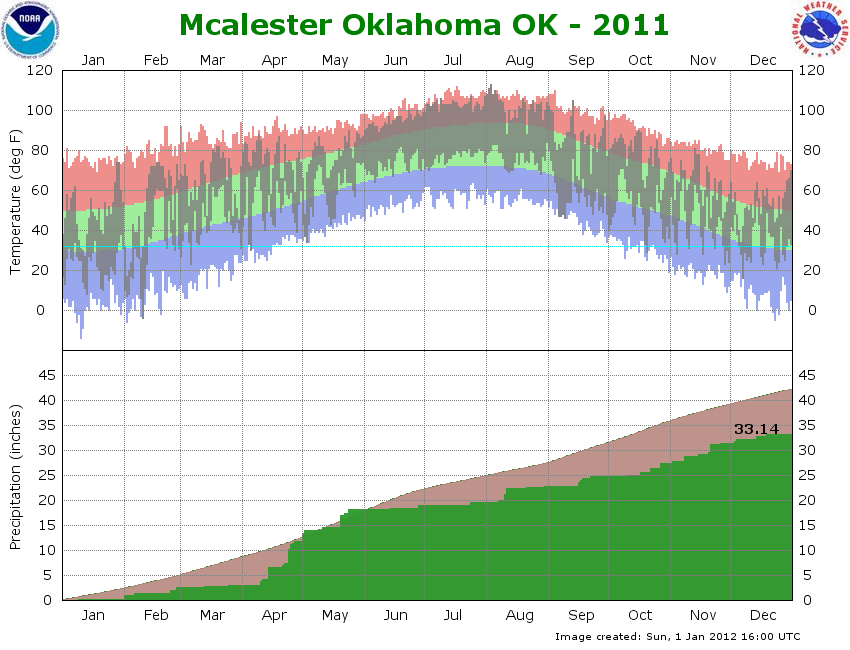
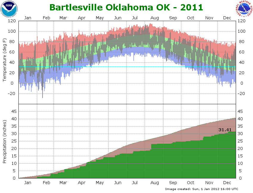
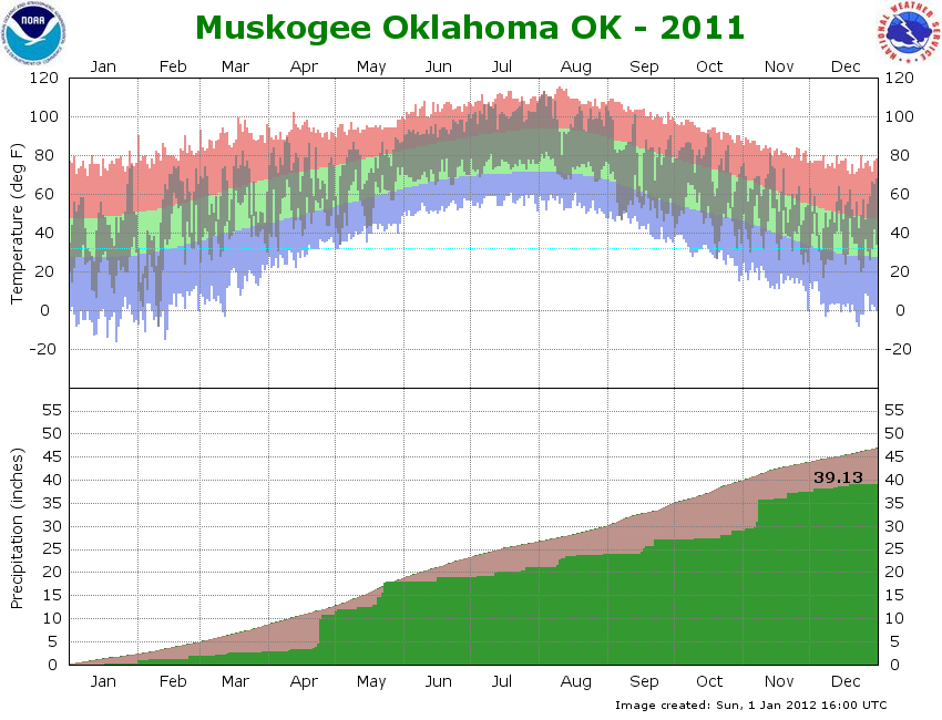
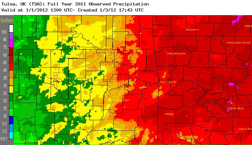
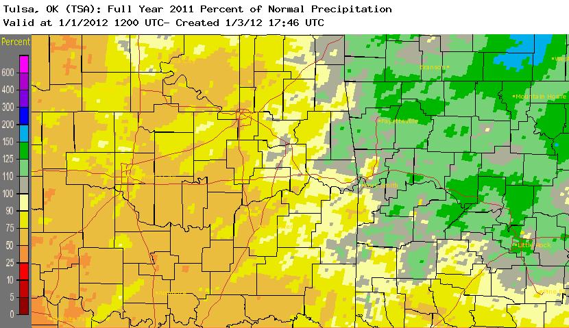
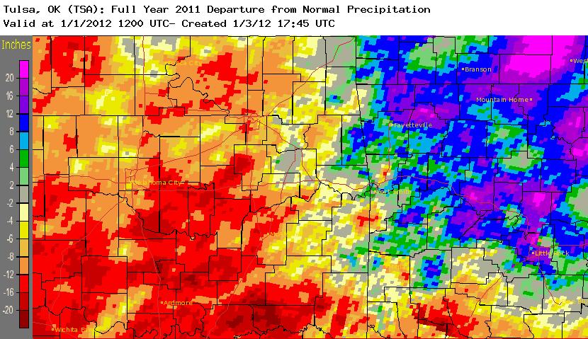
- While not a record, it is interesting to note that there has been a strong gradient of rainfall across eastern Oklahoma and northwest Arkansas this year. For 2011, Tulsa ranks as the 26th driest year on record while Fort Smith ranks as the 36th wettest year on record. Below is are images of the precipitation total, percent of normal preciptation, and the departure from normal for 2011. Click on an image for a larger view.
|
   |
|
| January |
- Several rounds of snow affected the region during January 2011. However, the most significant winter storm moved into the area January 31 and brought blizzard conditions and record snow through February 1. A new 24-hour snowfall record of 14" was set in Tulsa, OK, while 10"-15" snowfall totals were common across northeast Oklahoma. Read more about this event here.
|
|
| February |
- February 2011 was a month of extremes! From record snowfall and record cold temperatures at the beginning of the month, to record warm temperatures and a tornado at the end of the month.
|
|
|
|
|
- A Major Winter Storm affected the region February 8-9, 2011. Record breaking snowfall and cold temperatures occurred with this storm. Read about it here.
|
- Tulsa: February 2011 was the #1 snowiest (22.5"; since 1900) February on record and 18 daily records were set.
|
- Tulsa Snowfall Records broken during February 2011:
- Record cold season snowfall of 26.1". Previous record 25.6" in 1923-24.
- Record February snowfall of 22.5". Previous record 10.5" in February 2003.
- Record Monthly snowfall (any month) of 22.5". Previous record 19.7" in March 1924.
- Record 24-hour snowfall of 14.0" set on 01/31-02/01/2011. Previous record 12.9" on March 8-9, 1994.
- Record Maximum Storm Total Snowfall of 14.0" set on 01/31-02/01/2011. Previous record 12.9" on March 8-9, 1994.
- Record Maximum snowfall depth of 14.0" set on 2/02/2011. Previous record 11.0" January 7-8, 1988.
- Record Calendar Day Snowfall (for any day of the year) of 13.2" set on 2/01/2011. Previous record 12.1" on March 8, 1994.
|
- Muskogee: The minimum temperature of -8°F that occurred on 2/10/2011 was the coldest temperature ever recorded in Muskogee during the month of February.
|
- Record low temperatures on February 10, 2011 were followed by record warm temperatures only seven days later on February 17, 2011. Temperatures made a 90°F -110°F swing only one week at many locations! The 7-day 110°F temperature change at the mesonet site in Nowata was the greatest such change within seven days in Oklahoma history.
|
|
| March |
- McAlester: Only 0.52" of rain fell at McAlester Regional Airport in March 2011, which ranks as the driest March on record since records began in 1954. The previous record was 0.62" in 1954.
|
- According to the Oklahoma Climatological Survey (OCS), southeast OK ranked as the #1 driest March since records began in 1921.
|
|
| April |
- Due to the significant rain event April 21-27, new record river stages were set at the Illinois River near Watts, OK and the Baron Fork at Eldon, OK. Major flooding occurred along the Kings River near Berryville, AR and the Illinois River near Tahlequah, OK. Moderate and minor flooding affected several other mainstem rivers.
|
- April 2011 set the record for the most tornadoes in a month in the NWS Tulsa forecast area. There were 42 tornadoes in April, all of which occurred in a 12-day period. The previous record was 39 tornadoes in May 2010.
|
- April 14, 2011 broke the calendar day record for tornadoes in the NWS Tulsa forecast area, with 25 confirmed tornadoes. The previous forecast area record was 22 tornadoes on May 10, 2010.
|
- April 2011 also set the record for the most tornadoes in April for the State of Oklahoma: 50 tornadoes in April 2011 (previous record was 40 in 1957; records began in 1950).
|
|
| May |
- Fort Smith: The record cold mean temperature of 46°F set on 5/2/2011is the coldest mean temperature recorded in the month of May in Fort Smith.
|
- McAlester: The record cold max temperature of 48°F set on 5/2/2011 ties with 5/4/1954 as the coldest max temperature recorded in the month of May in McAlester.
|
- McAlester: The record cold mean temperature of 43°F set on 5/2/2011 is the coldest mean temperature recorded in the month of May in McAlester.
|
- Fayetteville: The record cold max temperature of 45°F set on 5/2/2011 is the coldest max temperature recorded in the month of May in Fayetteville.
|
- McAlester: The record minimum temperature of 34°F set on 5/3/2011 ties with 5/4/1954 as the coldest temperature recorded in the month of May in McAlester.
|
- Muskogee: The record minimum temperature of 34°F set on 5/3/2011 ties with 1981 as the coldest temperature recorded in the month of May in Muskogee.
|
- Fort Smith: The record rainfall of 4.71" set on 5/12/2011 is the highest calendar day rainfall recorded in the month of May in Fort Smith.
|
- Tulsa: The record warm minimum temperature of 77°F set on 5/19/2011 ties with 5/22/1953 and 5/31/1991 as the warmest low temperature recorded in the month of May in Tulsa.
|
- With the additional tornadoes that occurred during May 2011, the tornado total of 71 for eastern OK and northwest AR through May exceeded the highest annual number of tornadoes on record for the NWS Tulsa forecast area. The average number of tornados in the NWS Tulsa forecast area is around 20 tornadoes per year, and the previous record annual number of tornadoes in this area was 53, in both 1999 and 2008.
|
|
|
|
|
|
| June |
- Tulsa reached or exceeded 90°F on 29 out of 30 days in June 2011, which ties the record for the total number of 90°F days in the month of June. Twenty-nine 90°F days were also seen in June 1911 and 1934.
|
- Fort Smith: June 2011 was the warmest (85.0°F) June in Fort Smith since records began in 1883.
|
- Fort Smith: Fort Smith reached or exceeded 90°F on all 30 days in June 2011, which sets the record for the total number of 90°F days in the month of June. The streak of 90°F days began on 5/31/11.
|
- Fort Smith: The record warm min temperature of 84°F set on 6/27/2011 is the warmest low temperature ever recorded in the month of June in Fort Smith.
|
- McAlester: The record warm min temperature of 82°F set on 6/19/2011 ties with 6/28/1980 as the warmest low temperature recorded in the month of June in McAlester.
|
|
| July |
- Fort Smith: July 2011 was the warmest (91.2°F) July in Fort Smith since records began in 1883. July 2011 finished as the warmest month ever (for any month) recorded in Fort Smith.
|
|
|
|
|
|
|
- The Oklahoma statewide temperature for July 2011 was 89.3°F, making it the hottest July in state history. The previous record was 88.1°F in 1954. This also set the record for the hottest month (ANY month!) in Oklahoma state history and the hottest month in ANY state in the U.S. on record (back to 1895)! Read more about this from OCS.
|
|
| August |
- Tulsa: The low temperature of 87°F on 8/2/11 also tied the all-time record warm min temperature in Tulsa that was previously set on 7/26/1980.
|
- Tulsa: The mean temperature of 100°F on 8/2/11 set the all-time record warm mean temperature in Tulsa.
|
- Fort Smith: The high temperature of 115°F on 8/3/11 set the all-time record warm max temperature in Fort Smith.
|
- Fort Smith: The mean temperature of 100°F on 8/3/11 set the all-time record warm mean temperature.
|
- McAlester: The mean temperature of 97°F on 8/3/11 and 8/5/11 set the all-time record warm mean temperature in McAlester.
|
- Fayetteville: The low temperature of 83°F on 8/5/11 set the all-time record warm min temperature in Fayetteville.
|
|
|
- Fort Smith: Fort Smith saw its hottest meteorological summer on record. The average temperature of 88.2°F for the June through August period crushed the previous record of 85.7°F set during the summer of 1936.
|
- McAlester saw its hottest meteorological summer on record. The average temperature of 87.6°F for the June through August period beat the previous record of 86.2°F set during the summer of 1934.
|
- Fayetteville saw its hottest meteorological summer on record. The average temperature of 81.9°F for the June through August period just beat the previous record of 81.4°F set during the summer of 1980.
|
- The Oklahoma statewide temperature for Summer 2011 was 86.8F, making it the hottest Summer in state history. The previous record was 85.2°F in 1934. This also set the record for the hottest Summer in ANY state in the U.S. on record (back to 1895)! Oklahoma now holds 5 of the top 10 hottest summers across the U.S. since records began in 1895. Read more about this from OCS.
|
|
|
|
| September |
- Tulsa: The record warm minimum temperature of 82°F set on 9/01/2011 ties with 9/02/1936 and 9/03/1995 as the warmest minimum temperature recorded during the month of September in Tulsa.
|
- An historic drought during 2011 reached its peak during September, with almost 70% of Oklahoma experiencing exceptional drought conditions and 85% in the extreme-exceptional drought categories.
|
|
| October - no records set |
|
| November |
- Muskogee: The November 2011 rainfall total was 8.46", making this the wettest November on record in Muskogee. The previous record was 8.29" in 1946.
|
- While not weather-related, the strongest earthquake on record in Oklahoma happened on 11/05/11. Two strong earthquakes affected the region on November 5th. The first earthquake, which was a foreshock, was a magnitude 4.8 and occurred at 02:12:45 AM on the 5th (Nov. 5 07:12:45 UTC) near Prague, OK (20 miles northeast of Shawnee, OK or 41 miles west of Okmulgee, OK). The second earthquake was a magnitude 5.7 and occurred at 10:53:10 PM CDT on the 5th (Nov. 6 03:53:10 UTC). The epicenter was located 5 miles northwest of Prague, OK (21 miles north-northeast Shawnee, OK or about 75 miles southwest of Tulsa, OK) and occurred at a depth of 3.1 miles. This second earthquake was the largest recorded in Oklahoma (previous strongest OK earthquake was M5.5 April 9, 1952 near El Reno, OK) and was clearly felt from Dallas, TX to St. Louis, MO, which is about 300 miles from the epicenter. USGS reports indicated that this quake was felt as far away as Wisconsin and Indiana. The USACE inspected dams within 70 miles of the epicenter, including Keystone, Skiatook, Eufaula, and Heyburn, but no damage was discovered. A third strong aftershock earthquake of magnitude 4.8 occurred 6.4 miles NNW of Prague at 8:46:57 PM CST on the 7th (Nov. 8 2:46:57UTC).
|
|
| December |
- December was a quiet end to an otherwise tumultuous 2011 with no record-breaking weather.
|
| |