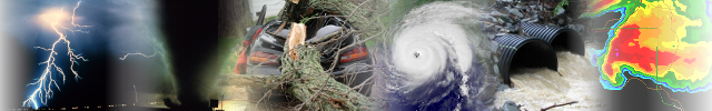
Severe Weather Awareness Week in New York
April 20 through April 26, 2025
Severe Weather Awareness Week in New York is from April 20 through April 26, 2025. NOAA's National Weather Service (NWS) joins in partnership with the agencies of the New York state Disaster Preparedness Commission, local agencies, volunteer agencies and private sector organizations in urging all residents to learn how to protect themselves from the hazards of flooding, tornadoes and severe thunderstorms.
Severe Weather Awareness Week is a time to learn more about thunderstorms, tornadoes, lightning and flooding and prepare for the dangers they bring to New York state during the spring and summer seasons.
Each day of Severe Weather Awareness Week will focus on a different topic. This will have a primary emphasis on weather safety and preparedness. Below are the topics that will be covered.
What is a Severe Thunderstorm?
What is a Tornado?
What is a flash flood?
A NOAA weather radio is the best way to find weather forecasts and receive weather warnings. The NOAA all hazard weather radio plays 24 hours/7 days a week. You can use your NOAA weather radio at home, work or when at play. NOAA weather radio provides continuous broadcasts of weather information with immediate relay of severe weather warnings. NOAA's NWS recommends everyone have access to a NOAA weather radio.
Today we will discuss what classifies a thunderstorm as severe, and the difference between a severe thunderstorm watch and a warning. We will also give you information on what to do when a watch or warning is issued.
What is a severe thunderstorm?
A severe thunderstorm is a thunderstorm that produces sustained wind or wind gusts of 58 miles an hour or greater, and/or hail of one inch in diameter or larger. Hailstones at the size of one inch in diameter, are the size of a quarter. Severe thunderstorms are often accompanied by torrential downpours and frequent cloud-to-ground lightning. Some severe storms can produce tornadoes with little or no advance warning. Severe thunderstorms can produce the same amount of damage as a weak tornado and are often mistaken for one.
What is a severe thunderstorm watch?
A severe thunderstorm watch means that atmospheric conditions are favorable for severe thunderstorms to develop and are expected within the next six hours. A watch is issued to alert you and your family that damaging winds, large hail and even an isolated tornado are possible. A watch does not mean severe weather is occurring. Severe thunderstorms watches can cover one or more states and can last for several hours at a time.
What should you do when a severe thunderstorm watch is issued?
Go about your normal activities, but watch the sky around you for developing storms. Periodically check your NOAA weather radio, cell phone for radar updates, TV, radio, or cell phone apps for updates to keep you weather aware. Always know which county you live in, and which ones borders your community. If you are on vacation, or driving through an unfamiliar area, keep a map on hand and know your location at all times in case danger arises. Newer cell phones are equipped with Wireless Emergency Alerts (WEA). WEA are emergency messages sent by authorized government alerting authorities through your mobile carrier. Government partners include: FEMA, FCC, Department of Homeland Security and
the NWS. WEA will allow you to receive extreme weather warnings, local evacuations, AMBER alerts and Presidential alerts during a national emergency. Always have a plan on how to get to a safe place quickly if a warning is issued for your area.
What is a severe thunderstorm warning?
A severe thunderstorm warning means a severe thunderstorm is going to move through your location soon. You need to take quick action to protect yourself, your family and your property. severe thunderstorm warnings are issued by the NWS when Doppler Radar weather radar has detected a severe thunderstorm, or when one has been reported by a trained weather spotter, a county emergency official, a law official, or a trusted report from the public. A warning is issued on average for 30 to 60 minutes.
What do you do when a severe thunderstorm warning is issued?
If caught outdoors, get inside a strong structure that has plumbing or electricity, or a car. If there is no building nearby, your best protection is in a ditch. Boaters should head to shore immediately. Remember, when Thunder Roars, Go Indoors! When you get inside a sturdy building, go into an interior room on the lowest level. Stay away from windows and doors. Do not use any electrical appliances.
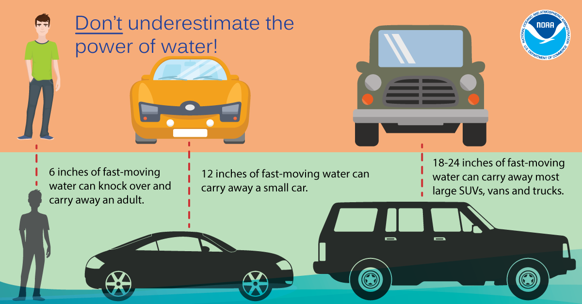
If you happen to be driving and you become caught in a severe thunderstorm, immediately pull over to the side of the road until the storm passes. Heavy rain with any thunderstorm can flood roads quickly. Never try to drive through an area where water covers the road, even if you think the water is shallow. The water may sweep your vehicle away. Turn around don't drown!
Today we discuss severe weather preparedness and safety. All thunderstorms, whether they are severe or not, are dangerous due to lightning. When one approaches, you need to protect yourself. When Thunder Roars Go Indoors! When you see a flash, dash inside! 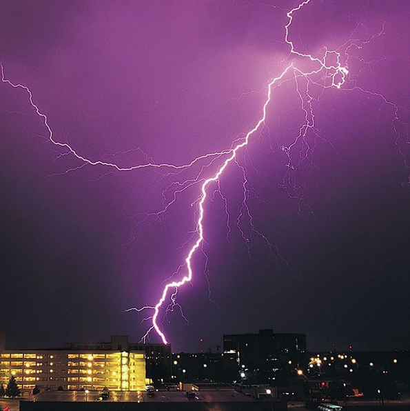
Before a storm, develop a safety plan so that you can protect your friends and family for many different scenarios. You need to have a safety plan for the home, when at school, at work and especially when outdoors. Being caught outdoors during a thunderstorm without a plan can turn deadly. Identify a safe place to take shelter and know what actions are needed when a warning is issued. The best way to do this is to conduct drills.
Lightning is a thunderstorm's biggest killer. Do not use electrical appliances or a computer while a thunderstorm is nearby.
If you are outdoors, seek shelter in a sturdy building with plumbing or electricity. Picnic shelters, dugouts, small buildings are not safe! Keep out of open areas such as pavilions or gazebos. Stay away from tall objects such as isolated trees and metal objects such as towers supporting power lines. Also, stay away from wire fences, clothes lines, metal pipes, and rails. If in an automobile, do not touch metal parts or the exterior. If in a school bus, close all windows and move to the center portion bus, have all students cross their feet and place their hands in their lap. The driver should not touch any metal in the bus.
Lightning may be about to strike if you are out in the open and feel your hair stand on end or your skin start to tingle. Run to seek proper shelter. There is no safe place outside once a lightning channel approaches from directly overhead (or very nearly so). You are likely to be struck and either killed or injured by the lightning strike.
During a thunderstorm, stay out of the water. If you are boating, head to shore at the first sign of threatening weather. In addition to the danger of lightning, gusty thunderstorm winds can easily capsize small boats.
Stay away from places that commonly flood during a thunderstorms. Flash floods caused by heavy downpours are another danger. Low lying areas, especially near streams and creeks, an flood rapidly. Never drive your car into a flooded area.
Remember, thunderstorms occasionally produce tornadoes. Sometimes thunderstorm winds are strong enough to produce EF-0 and EF-1 tornado like damage. Always be prepared to move to a safe shelter when a thunderstorm is near.
Today we discuss the difference between a tornado watch, a tornado warning, and provide tips on what to do when a watch or warning is issued.
What is a tornado?
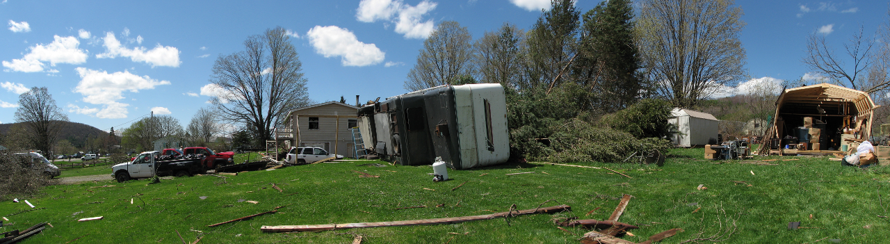
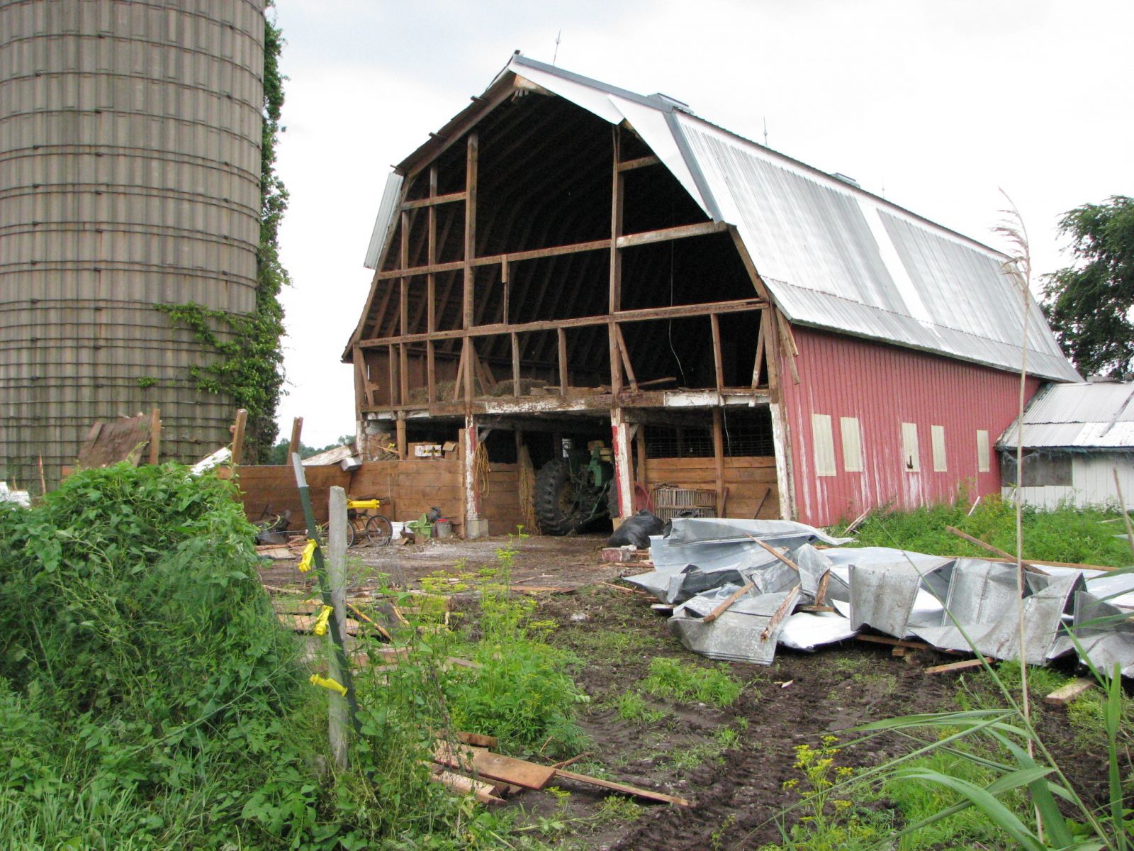
A tornado is a violently rotating column of air from the base of a thunderstorms that is in contact with the ground. Wind speeds inside a tornado range from under 100 miles an hour and can exceed 300 miles an hour. Tornadoes come in all shapes and sizes and can travel as fast as 70 mph, and can destroy virtually everything in their path.
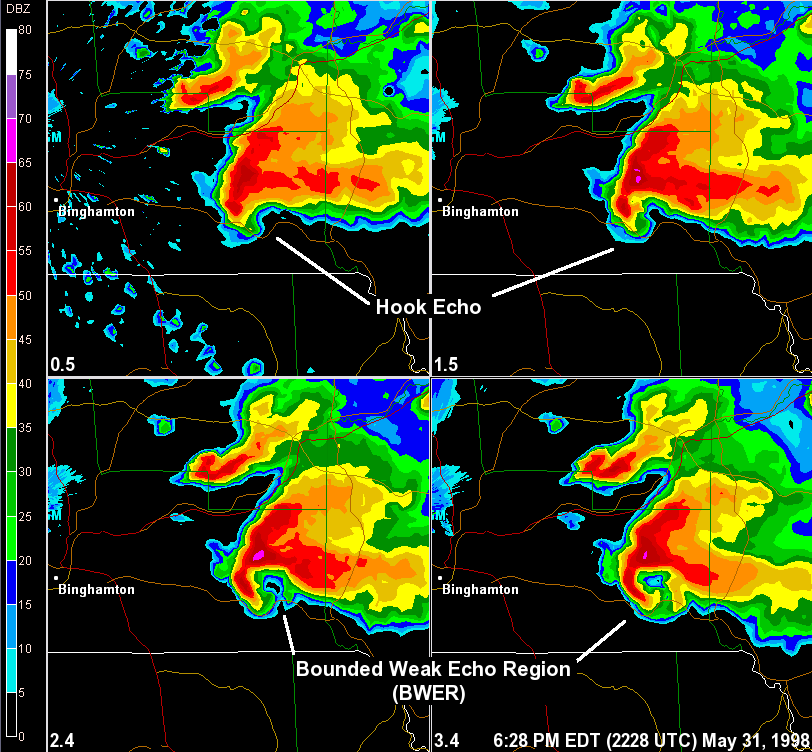
While the vast majority of tornadoes that occur in the state of New York are not as strong as their counterparts in the Midwest, strong and damaging tornadoes can and do occur here and in the northeast portion of the United States. On May 31st and June 2nd of 1998, central NY was hit by several tornadoes, some of which had wind speeds up to 200 mph! July 2012 had a tornado go through the heart of Elmira and track for almost 14 miles. On July 8th, 2014 a devastating tornado went through the town of Smithfield, NY and was at one point was 235 yards wide and had wind speeds up to 135 mph.
What does a tornado watch mean?
A tornado watch is issued when atmospheric conditions are favorable, over a large area, for tornadoes and severe thunderstorms to develop. A tornado watch is issued to alert you and your family that if a severe thunderstorm develops, a tornado is possible. It does not mean a tornado will occur with each thunderstorm, it just means it is possible. The NWS's storm prediction center issues all tornado watches for the whole CONUS. Tornado watches can be issued for several counties or even up to a few states.
What you should do when a tornado watch is issued?
Go about your normal activities, but watch the sky around you for developing storms. Periodically check your NOAA weather radio, cell phone for radar updates, TV, radio, or cell phone apps for updates to keep you weather aware. Always know which county you live in, and which ones borders your community. If you are on vacation, or driving through an unfamiliar area, keep a map on hand and know your location at all times in case danger arises. If you buy a new cell phone, make sure it is Wireless Emergency Alert Capable (WEA). Remember, WEA are emergency messages sent by authorized government alerting authorities through your mobile carrier. Government partners include: FEMA, FCC, Department of Homeland Security and the NWS. WEA will allow you to receive extreme weather warnings, local evacuations, AMBER alerts and Presidential alerts during a national emergency. Always have a plan on how to get to a safe place quickly if a warning is issued for your area.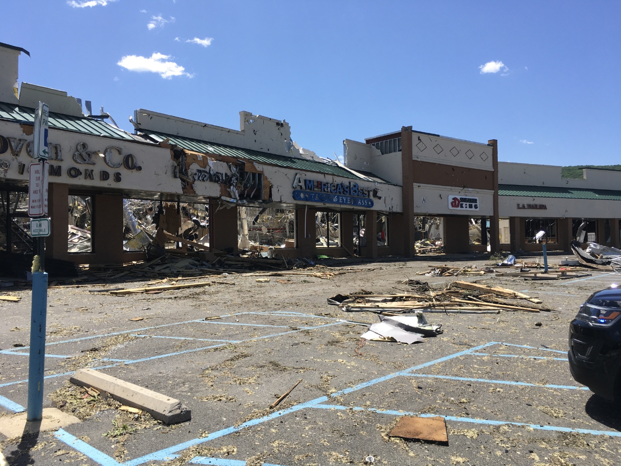
What does a tornado warning mean?
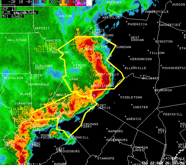
A tornado warning is issued when Doppler Radar shows a developing tornado, or a when tornado has been sighted by trained weather spotters, county emergency officials, law officials or credited calls from the public. Tornado warning means a tornado is going to move through your location soon, so you need to take immediate action to protect your life. Tornado warnings are issued by the NWS offices and typically range in duration from 30 to 60 minutes.
What you should do when a tornado warning is issued?
Take immediate action and remain calm. If you are at home or in a sturdy building, go to the basement or to an interior room on the lowest floor. Closets, bathrooms, and other interior rooms that offer the best protection. Get under something sturdy or cover yourself with a mattress.
If you are in a school, hospital, or shopping center go to a pre-designated shelter area. Stay away from large open areas and windows. Do not go outside to your car. Your car is a very dangerous shelter in place to go to in the event of a tornado. If you are in a high-rise building, go to an interior small room or hallway on the lowest floor possible. Do not use the elevator, only use the stairs instead.
For the best protection possible, get under something sturdy or drop to your knees facing an interior wall. Lean forward with your hands shielding your head. If at all possible wear a helmet. Get out of mobile homes or vehicles. They are easily tossed about by strong winds in the tornado. Take shelter in a substantial structure. If there is no shelter nearby, lie flat in a ditch or low spot with your hands shielding your head. Never stay inside the mobile home or vehicle.
Floods can be deadly
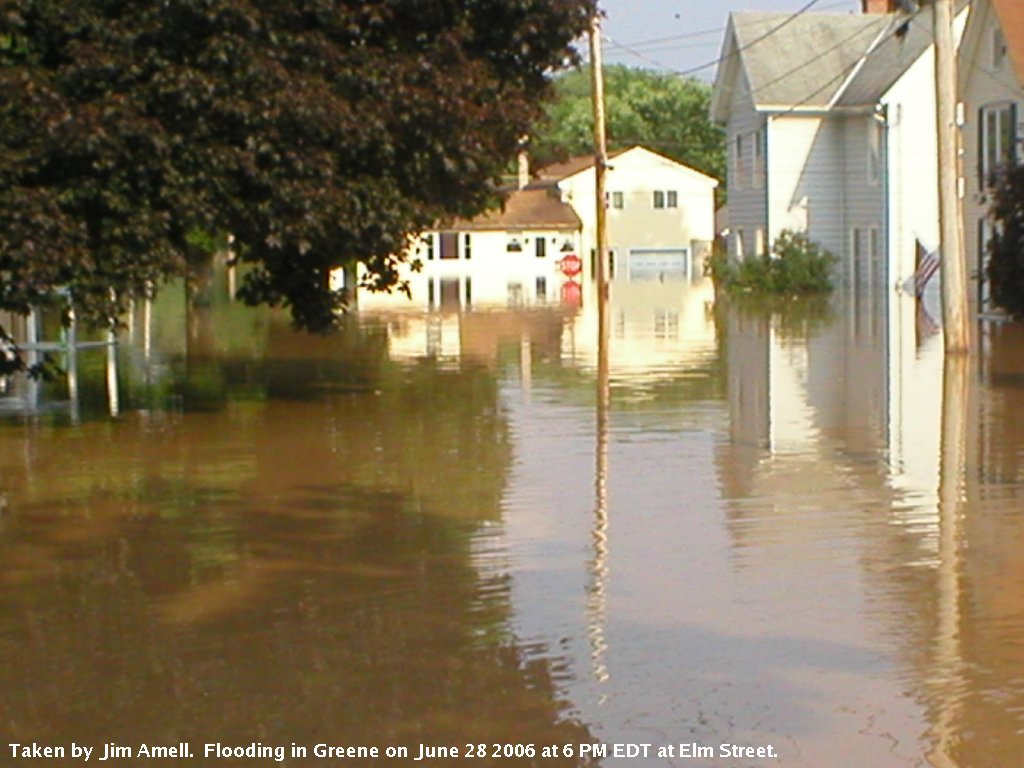
Floods are the number one killer in the United States among all weather-related natural hazards by almost a two-to-one margin. The main cause of death during floods comes from automobiles being swept away by flood waters. Many people die in floods because they try to cross flooded roadways. Turn around, don't drown!
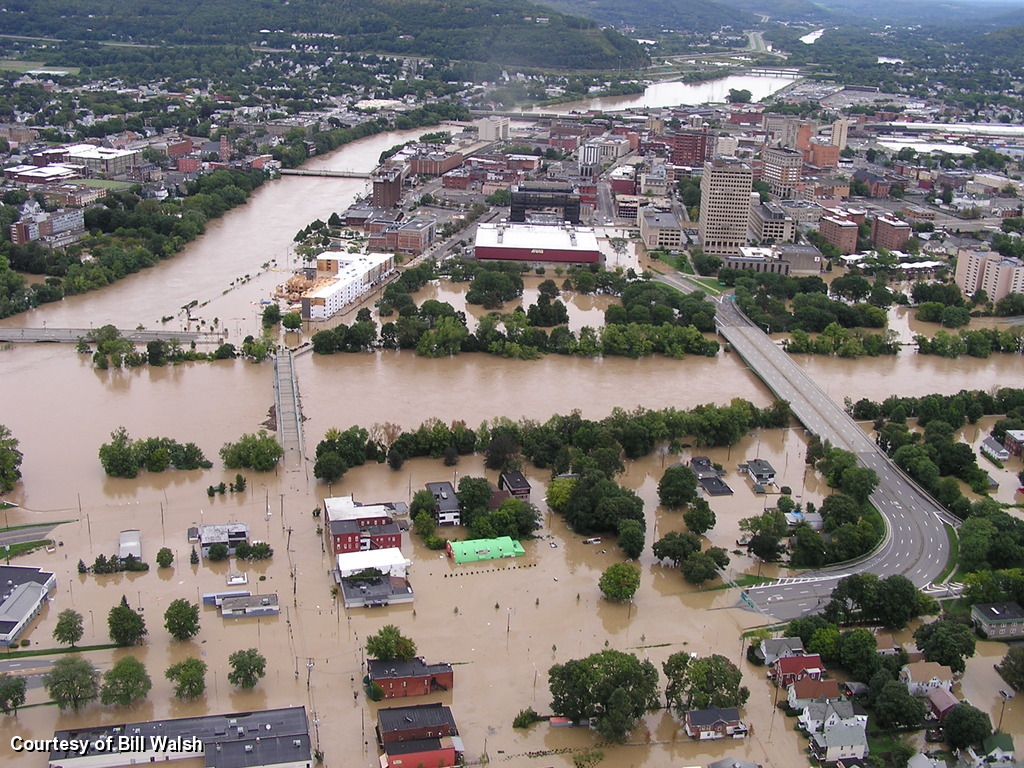
Central New York - A long history of floods
Devastating floods are no stranger to central New York. In fact,flooding ranks as the largest threat to many communities in our region. There are a few ways that flooding can develop over an area. Stationary thunderstorms can cause flooding. July of 1935 and 2007, major floods were created due to stationary thunderstorms in Delaware County, New York. August of 1955 back-to-back hurricanes, Connie and Diane struck southeast New York and created severe flooding in the vicinity of Poughkeepsie to Port Jervis. Tropical storms "Agnes" and "Eloise" both caused major floods across central New York in 1972 and 1975 respectively . Rapid snow melt combined with heavy rainfall resulted in major floods in 1996 - on the Schoharie Creek, the Mohawk River at Schenectady, the Hudson at Albany, the Susquehanna and Delaware river basins in central New York. A similar scenario occurred in April of 2005 across central New York. In June of 2006, a tropical feed of moisture parked over the area for several days caused significant flooding over a large portion of central New York. Tropical cyclones Irene and Lee also brought catastrophic flooding to central New York in September 2011.
What types of floods are there?
Floods which occur on small streams and creeks when heavy rain falls in a short period of time are known as flash floods. They are the deadliest of all floods and are the most difficult to forecast. Warning times can be very short. Flooding also occurs on our larger rivers and streams.
What does a flood watch mean?
A flood watch means there is potential for flooding to occur. This does not mean that flooding is occurring. A watch is typically issued for several counties at a time and ideally is issued 12 to 36 hours before flood is expected. This way you will have enough time to prepare.
What you should do when a flood watch is issued?
Go about your normal activities, but watch the sky around you for developing storms. Periodically check your NOAA weather radio, cell phone for radar updates, TV, radio, or cell phone apps for updates to keep you weather aware. Always know which county you live in, and which ones borders your community. If you are on
vacation, or driving through an unfamiliar area, keep a map on hand and know your location at all times in case danger arises. Newer cell phones are equipped with Wireless Emergency Alerts (WEA). WEA are emergency messages sent by authorized government alerting authorities through your mobile carrier. Government partners include: FEMA, FCC, Department of Homeland Security and the NWS. WEA will allow you to receive extreme weather warnings, local evacuations, AMBER alerts and Presidential alerts during a national emergency. Always have a plan on how to get to a safe place quickly if a warning is issued for your area.
 If you live or work in an area which is prone to flooding what do you do?
Have an evacuation route mapped out and ready to go if flooding occurs. Make sure everyone in your home or office knows where to go quickly if flooding occurs. Have a battery operated radio and flashlights available and in working order. Take precautions to secure your property. If you have to evacuate, and if you have time, turn off the gas and electricity to your home.
What does a flash flood warning mean?
A flash flood warning means a rapid life-threatening flood is occurring or will soon begin. You need to take action immediately to protect your life and property if you are in the danger area.
What you should do when a flash flood warning is issued?
Move to higher ground immediately and get out of the danger area. Never drive across bridges covered with water or through areas where water covers the roadway. If your car stalls in a flooded or low lying area, abandon it immediately. Rapidly rising flood waters could easily sweep it away. Water is extremely powerful. Be especially careful at night when it is harder to see flooded areas.
What does a river flood warning mean?
A river flood warning means that river levels will exceed flood stage at certain points along large rivers. Large rivers are defined such as: the Chemung, Susquehanna and Delaware rivers. River floods take longer to develop so they may not pose as much threat to life, but can take a much larger toll on property.
What should do when a river flood warning is issued?
If you live in a flood plain, be prepared to evacuate if ordered to do so. Make sure you have all necessary items that you would need in the event that you cannot return home for several days. Make arrangements to protect your property by moving your valuables to higher ground, or an upper level of your home.
Today we discuss becoming a Weather-Ready Nation.
Each year extreme weather events such as violent tornadoes or major hurricanes occur in the United States and result in devastating catastrophes which impacts millions of people. Severe weather events are an inevitable occurrence, and since we are at mother nature's mercy, it is only a matter of time until the next major weather event occurs. For this reason alone, this is why it is crucial we become a Weather-Ready nation.
The National Weather Service (NWS) is in the process of transforming its operations to help America respond more easily to disasters. We now provide forecast information in a way that better supports emergency managers, first responders, government officials, businesses and you make the best decisions to save lives and stay safe. While we are making great strides to become a great weather service and save as many lives as we can, we can not do it alone!
How can I help us build a Weather-Ready Nation?
You can become a Weather-Ready Nation Ambassador and help save lives. Becoming a Weather-Ready Nation Ambassador is easier than you think! Building a Weather-Ready Nation requires action from America's Weather Industry, emergency managers, researchers, the media, local schools and universities, nonprofits, and businesses. Any organization committed to serving as an example and engaging their stakeholders to make this country ready, responsive and resilient can become an Ambassador.![]()
If I become a Weather-Ready Ambassador, how can I help?
Start a dialog within your community to reduce the risk of being adversely impacted by extreme weather and water events to increase resilience for future events. Share NOAA pamphlets, graphics, and booklets providing weather safety and knowledge of weather events. Understanding different extreme weather events and how to prepare is key to survival.
How can I become a Weather-Ready Nation Ambassador?
Go to https://www.weather.gov/wrn/ambassadors/ and read the "Weather-Ready Nation Ambassador Initiative" and accept the terms. Next, fill out the Weather-Ready Nation Application information. Then click submit!
Where can I find NWS weather information to help build a Weather-Ready Nation?
Visit NWS WeatherReady Nation web site:
For more information or question please contact:
Mitchell Gaines
Meteorologist
National Weather Service Binghamton, NY
mitchell.gaines@noaa.gov
Binghamton, NY 13290
Phone: 607-770-9531

