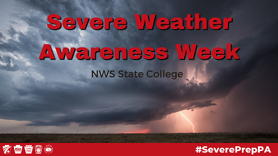
| MONDAY | TUESDAY | WEDNESDAY | THURSDAY | FRIDAY |
 |
||
|
Monday: Severe Thunderstorms We will cover what classifies a thunderstorm as severe, and what the differences are between a Severe Thunderstorm Watch and a Severe Thunderstorm Warning. We will also give you information on what to do when a watch or warning is issued for your area. What is a severe thunderstorm? A thunderstorm is considered severe if it produces wind gusts of 58 miles an hour or higher, and/or hail one inch in diameter or larger. Those hailstones are about the size of a quarter. Severe thunderstorms are often accompanied by torrential downpours and frequent lightning. They are also capable of producing tornadoes. The damage from the strong wind gusts of a severe thunderstorm can be just as bad as the damage made by a tornado. Tornadoes form from severe thunderstorms, but severe thunderstorms do not always have tornadoes. What is a Severe Thunderstorm Watch? A Severe Thunderstorm Watch is issued in order to alert you that thunderstorms with damaging winds and large hail are expected to develop close to your location. A watch by itself does not mean that severe weather is actually occurring yet, it means that severe weather is expected to happen close by. A severe thunderstorm watch usually covers an area as large as a state, and is in effect for several hours, expiring only when the thunderstorms are expected to end. What should you do when a Severe Thunderstorm Watch is issued? Plan your day knowing that severe thunderstorms are possible. Reschedule outdoor activities that fall under the time of the watch. Periodically check your local source for watch and warning updates like NOAA Weather Radio, local TV and radio, social media, or our website at www.weather.gov/ctp. What is a Severe Thunderstorm Warning? A Severe Thunderstorm Warning means a severe thunderstorm is happening or is about to happen and going to move through your location soon. It is your signal that you will need to take quick action to protect your life and property. Severe Thunderstorm Warnings are issued by the National Weather Service when meteorologists detect a severe thunderstorm using Doppler radar or when damage has been reported by trained SKYWARN weather spotters. Typically, a Severe Thunderstorm Warning will be issued for an area as big as a few counties or a part of a county, and for a period of up to one hour. In the text of the warning statement, we try to make a specific list of towns that are likely to be in the path of the storm. You should listen to hear if communities or landmarks near you are mentioned in the warning. What should you do when a Severe Thunderstorm Warning is issued for your location? If you are outdoors, get inside your home, a stable building, or your car. Boaters should head to shore immediately. When indoors, go to an interior room on the lowest level. Stay away from windows and exterior doors. Do not use electrical appliances and avoid using landline telephones, as lightning can travel through electrical and telephone lines. If you are driving, safely pull over to the side of the road until the storm passes. Heavy rain falling from any thunderstorm can flood roads quickly, so never try to drive through an area where water covers the road, even if you think it is shallow. Water may sweep your vehicle away if you attempt to drive through it. For additional thunderstorm and severe weather safety information
|
||
 |
||
|
Tuesday: Outlooks, Watches, and Warnings When severe weather is in the forecast, it is important to know the differences NWS products. What are Convective Outlooks issued by the Storm Prediction Center?
Convective Outlooks are issued 1 to 8 days in advance of severe weather. They highlight broad regions of possible severe weather events categorized by the predicted coverage and intensity of storms. The severe thunderstorm risk categories are as follows: general thunderstorms, marginal, slight, enhanced, moderate, and high. The higher the risk, the greater potential for intense and widespread severe storms. Outlooks have a lower confidence in the chance of occurrence than a watch or a warning. You can view the convective outlooks at www.spc.noaa.gov. What is a watch? Watches for severe weather are issued when conditions in the atmosphere are favorable for severe weather events. They have a higher confidence in the chance of occurrence than outlooks, but lower confidence than warnings. Watches are issued for regions over a few states to only a part of a state. Watches are typically issued a few days to a few hours before severe weather occurs. If a severe thunderstorm, tornado, or flash flood watch is issued for your area, take precautions and plan accordingly. What is a warning? A warning is issued when severe weather is imminent. Warnings cover smaller areas than watches; a few counties to only a part of a county. They are typically issued a few hours to a few minutes before severe weather occurs. If a warning is issued for your area, take action! Find shelter immediately and have a way to receive warning updates. How can I receive severe weather alerts? Make sure to have multiple ways to receive updates on watches and warnings for your area. You can receive updates through NOAA Weather Radio, social media, local TV and radio, and on our website at www.weather.gov/ctp. Configure your mobile phone for Wireless Emergency Alerts. Instructions can be found at www.ready.gov/alerts. Know the name of the county you live in and the names of the ones bordering your county.
Develop a severe weather action plan with your household that states where you will go during severe weather. Prepare an emergency kit that includes but is not limited to flashlights, batteries, phone chargers, water, non-perishable food, and a first aid kit. For additional information check out www.weather.gov/ctp/severeweatherawarenessweek Our weather safety topics for the rest of the week will be,
|
||
|
|
||
|
Wednesday: Flash Flooding More people are killed by flash floods than by other storm-related weather hazards. Unfortunately, most people succumb to flooding after they drive their automobiles into flooded roadways and are subsequently swept away to their deaths. If you encounter a flooded roadway, Turn Around, Don't Drown! Find another route, it could save your life! Many people lose their lives by not adhering to this simple rule, Turn Around, Don't Drown!
What is a flash flood? A flash flood is flooding that happens quickly! During a flash flood, a stream or creek will rise rapidly and crest generally within a few hours of the start of the heavy rain. Flash floods are so dangerous because the waters rise so quickly that they can catch people off guard and trap them in dangerous situations. This is why the National Weather Service constantly monitors rainfall using rain gauges and radar estimates, as well as monitoring stream and creek levels using automated river gauges and local spotters. Your National Weather Service will issue Flash Flood Watches and Flash Flood Warnings to help alert you to expected flood dangers. What causes flash floods? Flash floods are caused when very heavy rainfall, usually from slow-moving thunderstorms, overwhelms the natural or man-made drainage systems. Streams, creeks and smaller rivers are most vulnerable to flash flooding. Flash flooding occurs in urban areas as well as in rural areas.
What does a Flash Flood Watch mean? A Flash Flood Watch means that the potential exists for flash flooding to occur on any stream, creek or small river. The watch does not mean that flooding is imminent or occurring. It just means that it is a possibility. What should you do when a Flash Flood Watch is issued? Be prepared to take quick action to protect yourself by moving to higher ground if you are near a waterway. Watch water levels carefully and be ready to evacuate at any moment. If you are traveling during a Flash Flood Watch, be alert for signs of flash flooding, especially at night when it can be difficult to see a flooded roadway. Be very careful if driving through flood prone areas, and if you encounter a flooded roadway, Turn Around, Don't Drown! Find an alternate route. It could save your life! What does a Flash Flood Warning mean? A Flash Flood Warning means rapid life-threatening flooding is occurring, or will begin very soon. A warning lets you know that heavy rain will cause the water to rise and overflow the banks of the waterways nearby. A Flash Flood Warning can also be prompted by levee and dam failures. You need to take action immediately to protect your life and property if you are in the danger area. What should you do when a Flash Flood Warning is issued? Move up to higher ground immediately and get out of the danger area. Never drive across bridges covered with water, or through areas where water covers the roadway. Most cars will float in just 16 to 18 inches of water. If rising water captures your automobile, it could easily sweep you away. Be especially cautious at night, when it is harder to recognize that an area may be flooded. For additional information on flash floods and severe weather,
|
||
|
|
||
|
Thursday: Tornadoes What is a tornado? A tornado is a violently rotating column of air in contact with the ground. The wind speeds inside a tornado range from under 100 miles an hour up to 300 miles an hour. They can travel with a forward speed as fast as 70 mph, and can destroy virtually everything in their path. While most tornadoes that occur in Pennsylvania are not as strong as their counterparts in the plains, strong and damaging tornadoes can and do occur here. In fact, Pennsylvania ranks in the top 25 for tornado occurrence in the United States, averaging about fifteen tornadoes per year. Tornado Outbreaks, where several tornadoes occur within a few days, are not uncommon to Pennsylvania. Between May 31st and June 2nd of 1998, Pennsylvania was hit by 40 tornadoes, some of which had wind speeds over 200 mph.
What does a Tornado Watch mean? A Tornado Watch is issued by the National Weather Service in order to alert you that severe thunderstorms are expected to develop, and to highlight the potential for those storms to produce tornadoes. A Tornado Watch covers a very wide area, generally about the size of a state. A Tornado Watch will last for several hours, expiring only when the threat of thunderstorms is expected to end. What should you do when a Tornado Watch is issued? Plan your day around the watch valid time. Prepare your emergency kit if you have not already done so. Know a safe place to go if a warning is issued for your area. Periodically listen to NOAA Weather Radio or media outlets for updates and possible warnings. Know which county you live in, and which ones border your community. Think of a safe place to move to quickly if a tornado warning is issued for your location, or if thunderstorms approach. What does a Tornado Warning mean? A Tornado Warning is issued when meteorologists spot a developing tornado using Doppler radar, or when a tornado has been sighted by trained SKYWARN spotters. The warning means a tornado is going to move through your area soon, so you need to take immediate action to protect your life and property. Tornado Warnings issued by National Weather Service meteorologists typically cover areas smaller than one county, and for a duration of generally less than one hour. In the text of the warning statement, we try to make a specific list of towns that are likely to be in the path of the tornado. You should listen to hear if communities or landmarks near you are mentioned in the warning. What should you do when a Tornado Warning is issued for your area? Take immediate action, but remain calm. If you are at home or in a small building, go to the basement or to an interior room on the lowest floor. Closets, bathrooms, and other interior rooms without windows offer the best protection. Avoid windows and get under something sturdy or cover yourself with a mattress. If you are in a school, hospital, or shopping center, go to a pre-designated shelter area. Stay away from large open areas such as gyms or auditoriums, hallways and small interior rooms offer the best protection. Do not go outside to your car. If you are in a high-rise building, go to a small interior room or hallway on the lowest floor possible. Do not use the elevator. Mobile homes are easily tossed about by the strong winds of a tornado. Immediately take shelter in a substantial structure. If you are caught outdoors and cannot get to a safe building, as a last resort, you should: If you have access to a vehicle; get in, buckle your seat belt, and try to drive to the closest sturdy shelter. If your vehicle is hit by flying debris while you are driving, pull over and park. Stay in the car with the seat belt on. Put your head down below the windows, cover your head with your hands and a blanket, coat or other cushion if possible. If you can safely get noticeably lower than the level of the roadway, leave your car and lie in that low area, covering your head with your hands. Your choice of whether to stay in your car should be driven by your specific circumstances. If you are in a car or if you seek shelter in a depression or ditch with a tornado approaching, you remain at risk. The safest place to be is in an underground shelter, basement or safe interior room. For additional information on tornadoes and severe weather check out: www.weather.gov/tornado
|
||
|
|
||
|
Friday: Ways to Become Involved There are many different ways to become involved during severe weather with your local National Weather Service office. Programs include but are not limited to: SKYWARN Spotters. Each year, a dedicated group of volunteer weather spotters, known as SKYWARN, provide National Weather Service offices across the country with important, eyewitness, information about tornadoes, flash floods and severe thunderstorms. SKYWARN spotters are people with an interest in the weather, and an interest in helping others. While Doppler weather radars can help meteorologists identify rotating thunderstorms, SKYWARN spotters can help to pinpoint places where a tornado may form, even before a tornado touches ground. SKYWARN spotters are also essential to confirm that tornadoes have touched down, to report on the extent of damage, and to provide added details of a threat to a community.
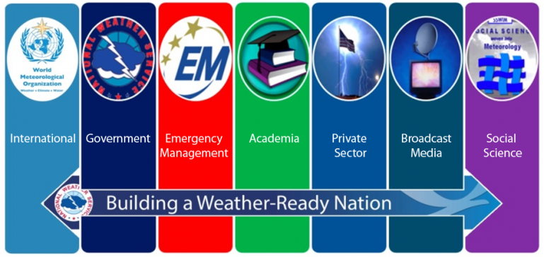
A large number of SKYWARN spotters are also ham radio operators. Amateur radio emergency groups and amateur radio clubs are called into action whenever Tornado or Severe Thunderstorm watches or warnings are in effect across the commonwealth. These spotters collect information via ham radio nets, and then relay that information to emergency management and to the national weather service. A way for an entire organization to become involved is Weather Ready Nation. Weather Ready Nation is an initiative for organizations external of the National Weather Service to build community resilience during severe weather. Building a Weather Ready Nation requires innovative partnerships with other weather information providers (i.e., the Weather Enterprise), and with organizations across all segments of society for better community, business, and personal decision making. Weather Ready Nation Ambassadors create outreach content, collaborate on disaster preparedness, and incorporate weather, water, and climate information in decision making. A part of the Weather Ready Nation is a program called StormReady. StormReady helps prepare communities with the communication and safety skills needed to save lives and property--before, during and after the event. StormReady helps community leaders and emergency managers strengthen local safety programs. StormReady communities, counties, Indian nations, universities and colleges, military bases, government sites, commercial enterprises and other groups are better prepared to save lives from the onslaught of severe weather through advanced planning, education and awareness. No community is storm proof, but StormReady can help communities save lives.
All the staff of your National Weather Service would like to thank our many friends in the SKYWARN program, thank you for your great help. Your volunteer efforts are very much appreciated. Be prepared for the dangers of this severe weather season, and consider becoming a SKYWARN spotter, HAM Radio operator, Weather Ready Nation Ambassador, or StormReady Supporter.
|
||


 Send Us a Report