National Weather Service United States Department of Commerce

Heat and Fire Weather Concerns for the Center of the Nation; Coastal Impacts Across the East

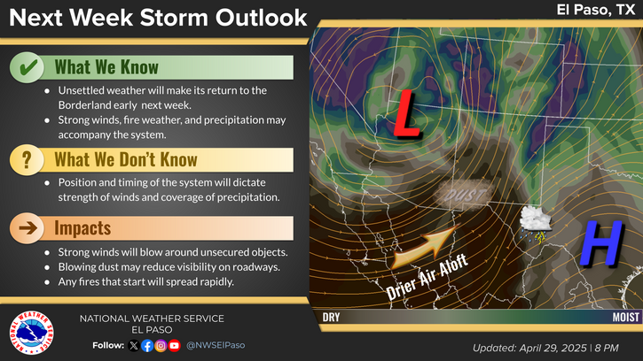
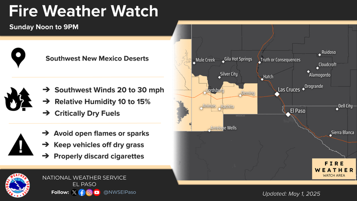
Excessive heat returns for portions of the Plains today where heat indices will likely climb above the century mark. Furthermore, warm temperatures, strong winds and dry fuels may result in rapid spread of wild fires across the western High Plains today. For the east coast, lingering storm with onshore flow will bring high surf, dangerous rip currents and coastal flooding, especially at high tide. Read More >

Click a location below for detailed forecast.

Last Map Update: Fri, Sep 20, 2024 at 2:14:46 pm MDT

Scattered showers and isolated thunderstorms are expected this afternoon and evening primarily east of Hwy 54. Isolated shower and storms will be seen elsewhere. The primary hazards will be frequent lightning and gusty outflow winds from thunderstorms.
Friday: A low pressure trough will bring active weather conditions to areas mainly east of the Rio Grande. Expect a 15 to 40% chance for showers and thunderstorms across the Otero and Hudspeth counties during the day. The winds will be generally light to breezy and out from the south southwest. The skies will be partly cloudy cloudy with the high temperatures in the afternoon above the climatological normal.
Weekend Outlook
5 Day Outlook
Seven Day Rainfall Forecast

Link to Briefing page
Briefing

Forecast
Discussion
Weather Hazards Outlook icon
Weather Hazards
Outlook

Hourly Forecast

Gridded Forecast

Weather Calculator

Link to Observation Page
Current
Observations


Satellite


Climate
Data


Past Weather

Drought

Hydrology

Wx Radio

Skywarn

Fire Weather

Volunteer

Aviation

Social Media