Grand Junction, CO
Weather Forecast Office
A winter storm will impact eastern Utah and western Colorado from this evening through Tuesday morning. This system has the potential to generate 10 to 18 inches of new snow over Colorado's western mountains, and from 8 to 14 inches of snow over the eastern Uinta Mountains of northeast Utah. The Roan, Tavaputs, and Uncompahgre Plateaus and the La Sal and Abajo Mountains are more likely to experience 6 to 12 inch accumulations with locally higher amounts. Ahead of the cold front associated with this system, strong and gusty southwest winds from 20 to 30 mph with gusts of 40 to 50 mph will spread from southeast Utah to northwest Colorado this afternoon. Once the storm is through, expect markedly colder temperatures on Tuesday with highs falling shy of seasonal norms by 10 to 15 degrees. Winter Storm Watches are in place for several mountain sites from Sunday evening through Tuesday morning. Stay tuned for updates on this developing winter storm.
.png) Winter Weather Warnings and Advisories
Winter Weather Warnings and Advisories
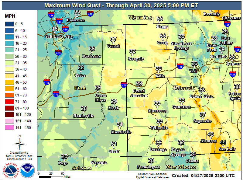
Wind Advisory from Noon to 5 PM this Afternoon
(1).png)

Hazards
Detailed Hazards Viewer
Outlooks
Winter Storm Severity Index
Transportation Decision Support
National Briefing
Current Conditions
Observations
Radar
Satellite
Snow Cover
Snowfall Analysis
Precip Analysis
Social Dashboard
Forecasts
Fire Weather
Recreation Areas
Forecast Discussion
Hurricane Center
Aviation Weather
Winter Weather
Activity Planner
Recreation Areas
Severe Weather
Local Area
User Defined Area
Hydrology
Recreational River Report
Rivers and Lakes
Weather Safety
Preparedness
NOAA Weather Radio
StormReady
SkyWarn
Spotter Training Calendar
US Dept of Commerce
National Oceanic and Atmospheric Administration
National Weather Service
Grand Junction, CO
2844 Aviators Way
Grand Junction, CO 81506-8644
970-243-7007
Comments? Questions? Please Contact Us.

