April 30, 2017 Tornado Outbreak
Event Summary
During the early morning hours of April 30th, a squall line of severe thunderstorms developed across central Louisiana and pushed eastward across the National Weather Service Jackson, MS forecast area. The line intensified as it approached the Mississippi River and evolved into a Quasi-Linear Convective System (QLCS). Numerous tornadoes (29) developed along the line, with the most prolific damage occurring along the track of a large mesovortex which tracked from Claiborne County through western Hinds/Madison, eastern Yazoo, eastern Holmes, southeastern Carroll, Montgomery, and northwestern Webster counties.
Our region is no stranger to tornadoes, squall lines or tornado outbreaks. However, what occurred Sunday morning, April 30th, was quite rare. Here’s a general explanation of a very complex situation. As the squall line of storms was taking shape across central Louisiana, a mesoscale convective vortex (MCV) began to develop. This feature is on a smaller scale than traditional low pressure areas and usually ranges in diameter between 20 to 50 miles. This particular MCV developed as a large cluster of storms merged with the evolving squall line. Intensifying downdrafts caused bowing segments in the line to surge out. Due to the strong ambient wind shear in place, strong updrafts along the bowing line became oriented more favorably with the underlying wind shear. As this occurred, smaller scale circulations quickly developed. These circulations are called meso-vortices and are the features responsible for producing the tornadoes our region experienced. A feedback mechanism began at this point and the larger “parent” MCV was able to be maintained as it continued to modify the environment driving stronger wind shear which in turn supported strong and multiple quickly developing meso-vortices as the system moved northeast. This all combined to support and maintain an efficient tornado producing feature rarely seen. While hard to describe and visualize, this larger vortex was essentially on the ground and was generating smaller vortices that were rotating around the parent circulation. The end result was substantially wide tornado paths, numerous tornadoes, and additional wind damage away from the tornadic vortices.
For a historical perspective, this event ranks as 4th on the number of tornadoes (29) produced across the forecast area. Also of note, other similar efficient tornado producing MCVs are quite hard to identify. Most recent are two that occurred during the early morning squall line from April 27, 2011. One was in central Mississippi (very near the recent impacted area), and the other in northern Alabama. There are likely other instances of these systems in the past, but these likely occurred before Doppler Radar which is a tremendous tool in identifying the smaller scale meso-vortices and how the data aids the damage survey process.
In addition, strong straight line winds occurred in some areas. A 71 mph wind gust was recorded at the Greenwood-Leflore Airport. Flash flooding was also reported in some areas including Vicksburg, Bentonia, Hattiesburg, and Laurel.
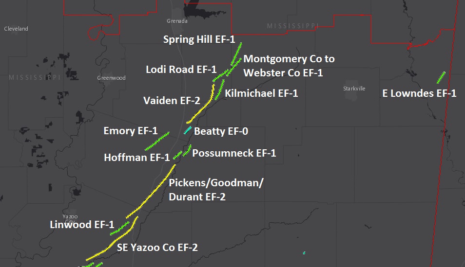
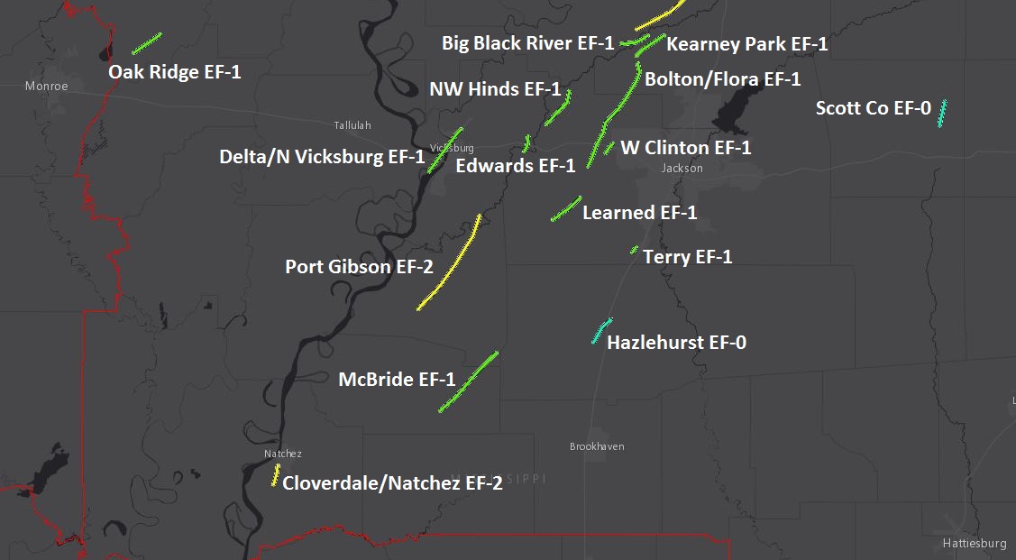
Tornado Track Maps
North half
South half
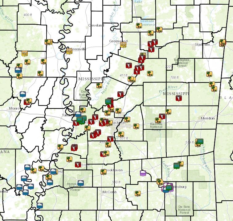
Local Storm Reports
Click on the map for additional details.

Survey Information
Click on the location in the table for additional maps and details below.
| Location | Start/ End Time |
Event Type | Fatalities/ Injuries |
Path Length | Path Width |
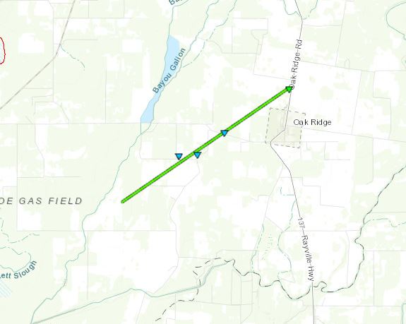
| Morehouse Parish 5 WSW Oak Ridge to 1 N Oak Ridge |
4:44 AM - 4:54 AM |
EF-1 Tornado 95 mph |
none | 5.72 miles | 50 yards |
| Adams County 5 SSW Natchez to 2 SW Natchez |
6:14 AM - 6:24 AM |
EF-2 Tornado 115 mph |
none | 3.43 miles | 1/4 mile |
| Madison Parish and Warren County 3 SW Delta to 5 N Vicksburg |
7:13 AM - 7:27 AM |
EF-1 Tornado 100 mph |
none | 9.39 miles | 1/4 mile |
| Jefferson and Claiborne Counties 8 ESE Fayette to 16 ESE Port Gibson |
7:24 AM - 7:42 AM |
EF-1 Tornado 105 mph |
none | 14.46 miles | 1/4 mile |
| Claiborne and Warren Counties 1 S Port Gibson to 11 WNW Utica |
7:30 AM - 7:55 AM |
EF-2 Tornado 115 mph |
none | 20.03 miles | 1/2 mile |
| Copiah County 4 WSW Hazlehurst to 3 NNW Hazlehurst |
8:01 AM - 8:07 AM |
EF-0 Tornado 85 mph |
none | 5.23 miles | 100 yards |
| Hinds County 3 SSW Learned to 3 ENE Learned |
8:10 AM - 8:17 AM |
EF-1 Tornado 110 mph |
none | 6.16 miles | 300 yards |
| Hinds and Warren Counties 3 W Edwards to 4 NW Edwards |
8:14 AM - 8:18 AM |
EF-1 Tornado 94 mph |
none | 2.75 miles | 1/2 mile |
| Hinds and Madison Counties 3 S Bolton to 1 NNW Flora |
8:22 AM - 8:47 AM |
EF-1 Tornado 110 mph |
none | 20.79 miles | 1/2 mile |
| Hinds County 5 N Edwards to 10 NNW Bolton |
8:23 AM - 8:33 AM |
EF-1 Tornado 107 mph |
none | 7.37 miles | 1 mile |
| Hinds County 2 SW Terry to 1 WSW Terry |
8:23 AM - 8:26 AM |
EF-1 Tornado 90 mph |
none | 1.07 miles | 150 yards |
| Hinds County 3 ESE Bolton to 3 WNW Clinton |
8:28 AM - 8:31 AM |
EF-1 Tornado 100 mph |
none | 2.06 miles | 500 yards |
| Madison County 3 NNW Flora to 7 NNE Flora |
8:50 AM - 8:54 AM |
EF-1 Tornado 100 mph |
none | 6.05 miles | 400 yards |
| Yazoo and Madison Counties 2 S Bentonia to 5 E Bentonia |
8:51 AM - 8:57 AM |
EF-1 Tornado 105 mph |
none | 5.08 miles | 0.8 mile |
| Yazoo County 3 ENE Bentonia to 4 WSW Pickens |
8:54 AM - 9:17 AM |
EF-2 Tornado 120 mph |
none | 22.25 miles | 1.2 miles |
| Yazoo County 13 NE Bentonia to 8 SW Pickens |
9:06 AM - 9:14 AM |
EF-1 Tornado 110 mph |
none | 6.94 miles | 1000 yards |
| Yazoo, Holmes, and Attala Counties 7 WSW Pickens to 3 NE Durant |
9:16 AM - 9:41 AM |
EF-2 Tornado 120 mph |
Deaths: 1 | 23.44 miles | 1.2 miles |
| Holmes and Carroll Counties 5 NE Lexington to 6 NW West |
9:38 AM - 9:49 AM |
EF-1 Tornado 90 mph |
none | 9.16 miles | 400 yards |
| Scott County 5 NE Forest to 6 W Conehatta |
9:41 AM - 9:47 AM |
EF-0 Tornado 80 mph |
none | 4.27 miles | 100 yards |
| Holmes County 4 NNE Durant to 2 S West |
9:42 AM - 9:45 AM |
EF-1 Tornado 100 mph |
none | 3.04 miles | 600 yards |
| Attala County 3 SSE West to 3 E West |
9:42 AM - 9:46 AM |
EF-1 Tornado 95 mph |
none | 3.92 miles | 600 yards |
| Carroll County 4 N West to 3 SSE Vaiden |
9:51 AM - 9:55 AM |
EF-0 Tornado 80 mph |
none | 2.64 miles | 250 yards |
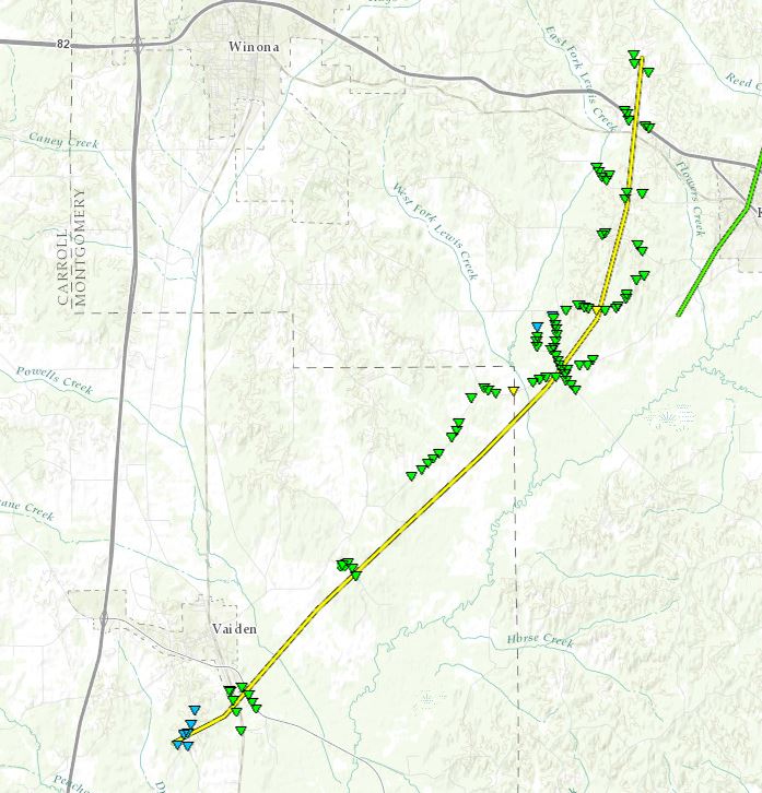
| Carroll and Montgomery Counties 2 S Vaiden to 4 NW Kilmichael |
9:58 AM - 10:13 AM |
EF-2 Tornado 115 mph |
none | 15.75 miles | 1 mile |
| Montgomery County 2 SW Kilmichael to 4 N Kilmichael |
10:11 AM - 10:15 AM |
EF-1 Tornado 110 mph |
none | 6.67 miles | 0.55 miles |
| Montgomery County 5 NNW Kilmichael to 8 NNE Kilmichael |
10:13 AM - 10:19 AM |
EF-1 Tornado 100 mph |
none | 5.66 miles | 800 yards |
| Montgomery and Webster Counties 6 NNE Kilmichael to 10 W Walthall |
10:14 AM - 10:20 AM |
EF-1 Tornado 95 mph |
none | 6.75 miles | 650 yards |
| Neshoba County 3 WSW Tucker |
10:17 AM - 10:18 AM |
EF-0 Tornado 85 mph |
none | 0.29 miles | 50 yards |
| Webster County 10 NNE Kilmichael to 6 SW Slate Springs |
10:18 AM - 10:23 AM |
EF-1 Tornado 110 mph |
none | 7.42 miles | 600 yards |
| Lowndes County 3 NNW New Hope to 6 ENE Columbus |
11:37 AM - 11:42 AM |
EF-1 Tornado 110 mph |
none | 3.82 miles | 1/4 mile |
Click on map above to see entire damage point notation and damage pictures at select points.
|
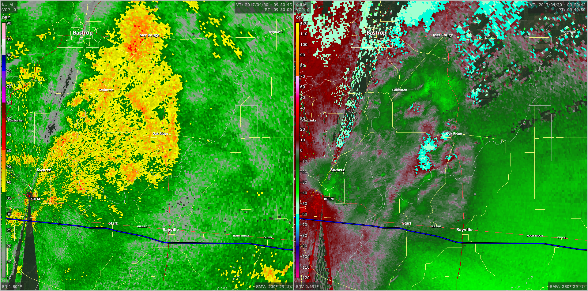
Track Summary There is some uncertainty where this tornado first touched down and dissipated due a number of farm fields and limited damage. Based on radar information and surrounding evidence, it was determined that it started in a field. The greatest damage occurred near the intersection of School House Lane and Sidney White Rd. A well-structured home had significant roof damage, and a playhouse and shed were completed destroyed. On the University of Louisiana-Monroe radar, a TDS was visible near this home. A number of uprooted trees were sporadically down around the edge of the circulation and were probably caused by straight line winds. On Hwy 425, north of Oak Ridge, a few power poles had to be replaced. This is where it was determined that the tornado dissipated. |
|
Radar Imagery
These images from the Monroe radar, courtesy of the University of Louisiana-Monroe, show the storm at 4:49 am as the tornado was located just west of Oak Ridge. The image on the left shows 1.8° base reflectivity data, and the image on the right shows 0.5° storm relative velocity data. Click on the thumbnail below for a higher resolution image.
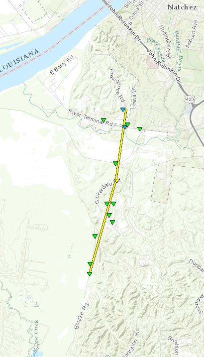
Cloverdale/Natchez EF-2 Tornado
Click on map above to see entire damage point notation and damage pictures at select points.
|
Track Summary The tornado began along Bourke Road and uprooted numerous trees along its path. The worst damage occurred in the Cloverdale area. Here, a large tree destroyed a home along Cloverdale Dr. The strongest point of the tornado occurred along Cloverdale Road, where a large portion of the roof was removed from a home as well as numerous trees snapped and uprooted. As the tornado crossed Carthage Point Road, many trees were uprooted and one fell on a church. The tornado continued north and crossed River Terminal Road, where a roof was blown off of a stable and one home suffered damage from an uprooted tree. The tornado finally dissipated along Providence Road. A tornado debris signature was also noted on radar during this event. |
|
Radar Imagery
These images from the Fort Polk, LA radar show the storm at 6:18 am as it moved through the Cloverdale community. The image on the left shows 0.5° base reflectivity data, and the image on the right shows 0.5° storm relative velocity data. Click on the thumbnail below for a higher resolution image.

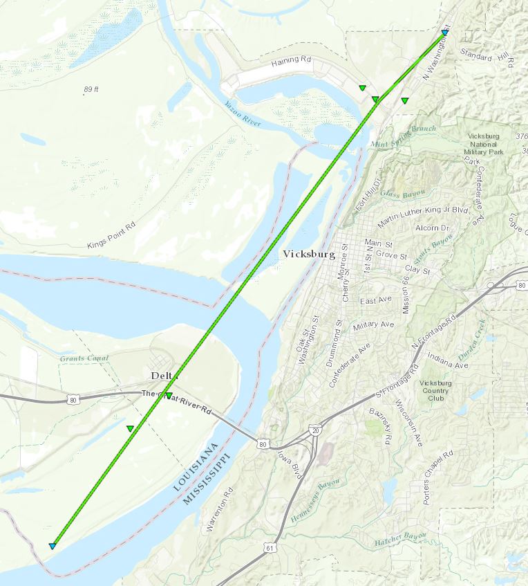
Delta/North Vicksburg EF-1 Tornado
Click on map above to see entire damage point notation and damage pictures at select points.
|
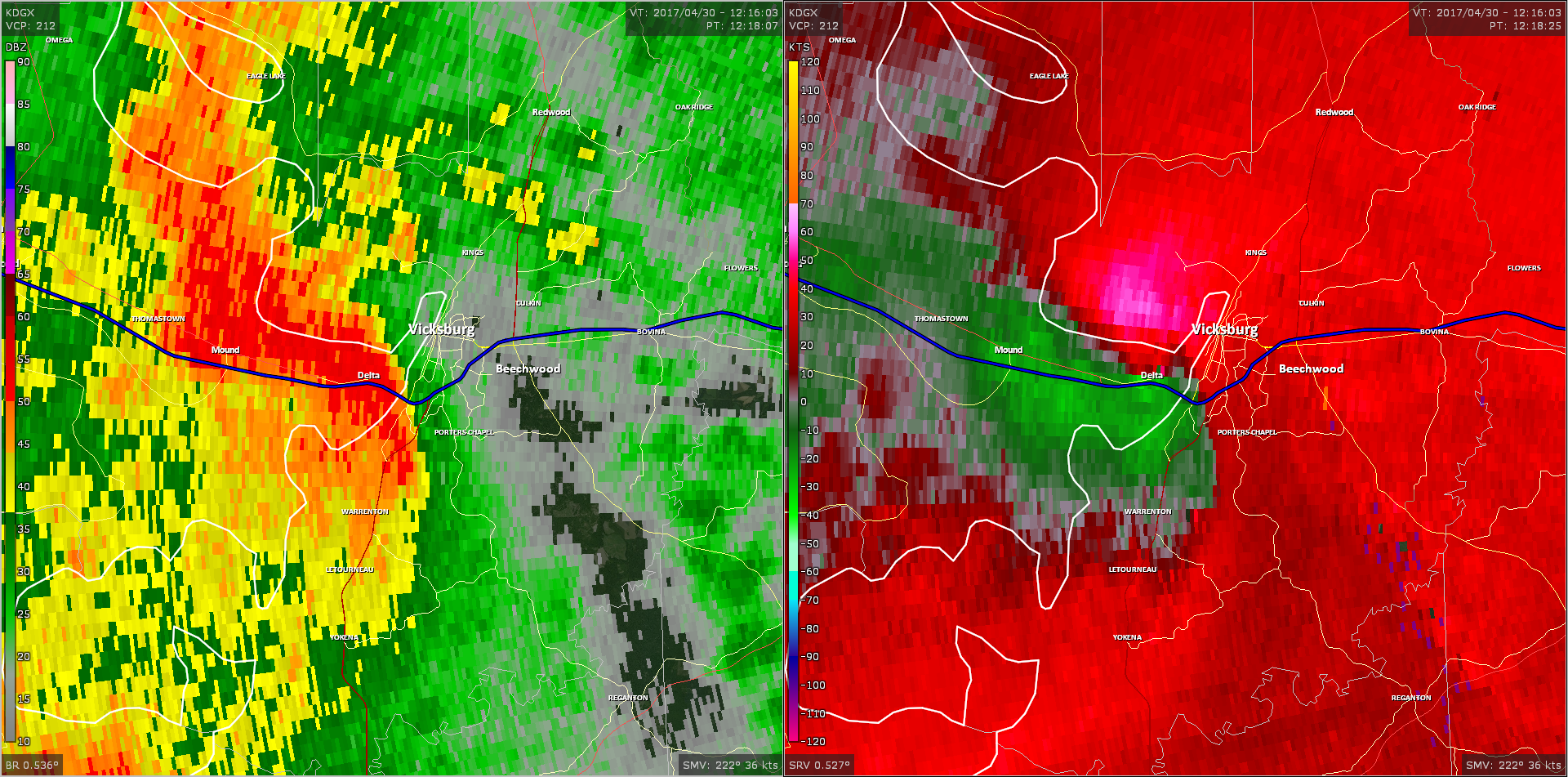
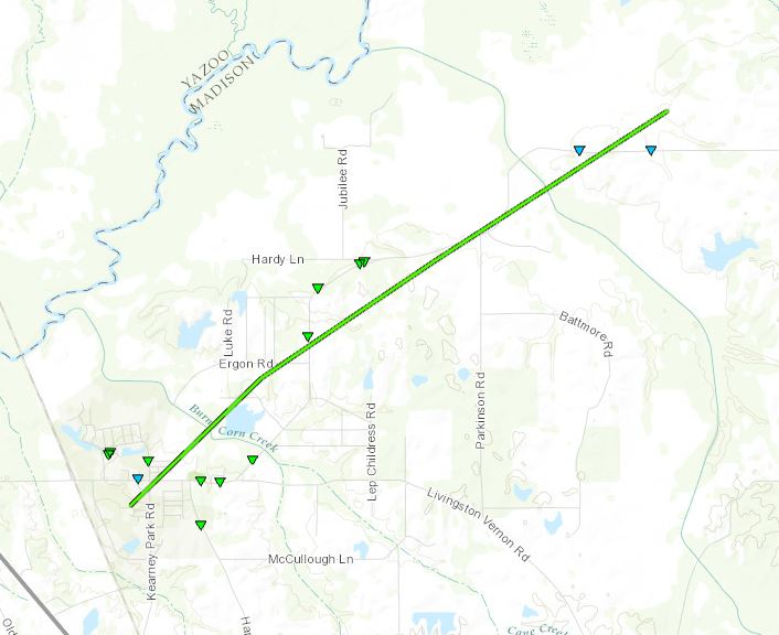
Track Summary This tornado began just south of Interstate 20 in Madison Parish, around Delta. It snapped or uprooted numerous trees in this location as well as damaged a road sign as it crossed over I-20. The tornado then crossed the Mississippi River, and reached around one quarter of a mile wide as it entered Warren County on the northern outskirts of Vicksburg. Here, it snapped numerous hardwood trees as well as brought down some powerlines and damaged the garage door of a building along Haining Road. The tornado then broke power poles along North Washington Street north of Waltersville before finally lifting just north of that location. A debris signature was noted on radar along the path of this tornado. |
|
Radar Imagery
These images from the Brandon, MS radar show the storm at 7:18 am as the tornado passed through the Delta area. The image on the left shows 0.5° base reflectivity data, and the image on the right shows 0.5° storm relative velocity data. Click on the thumbnail below for a higher resolution image.
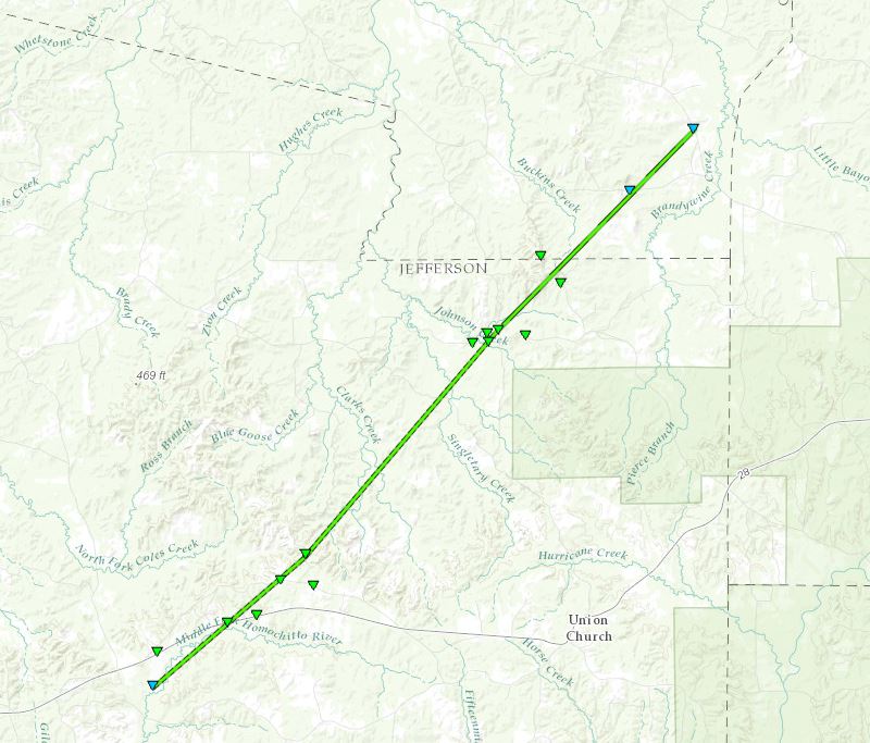
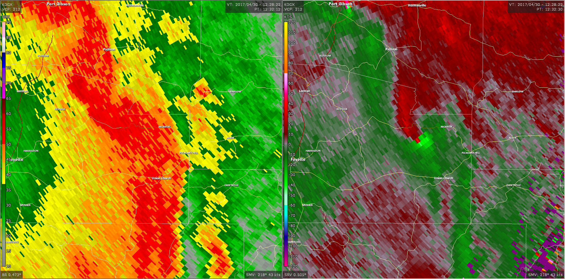
East Jefferson Co/Southeast Claiborne Co/McBride EF-1 Tornado
Click on map above to see entire damage point notation and damage pictures at select points.
|
Track Summary This tornado touched down just south of Highway 28. A few trees were downed and snapped in this area. As it continued northeast through rural area, numerous trees were snapped and uprooted. It then crossed McBride Road and Pap Goza Road, uprooting and snapping many large trees. It also snapped a powerpole and caused extensive roof damage to a few chicken houses. It continued northeast into Claiborne County, crossing Hudson Road and Beech Grove Road. The tornado ended near Northeast Smith Road, snapping a couple of trees before lifting. A tornado debris signature was also noted on radar during this event. |
|
Radar Imagery
These images from the Brandon, MS radar show the storm at 7:32 am as the tornado approached the McBride community. The image on the left shows 0.5° base reflectivity data, and the image on the right shows 0.5° storm relative velocity data. Click on the thumbnail below for a higher resolution image.
Click on map above to see entire damage point notation and damage pictures at select points.
|
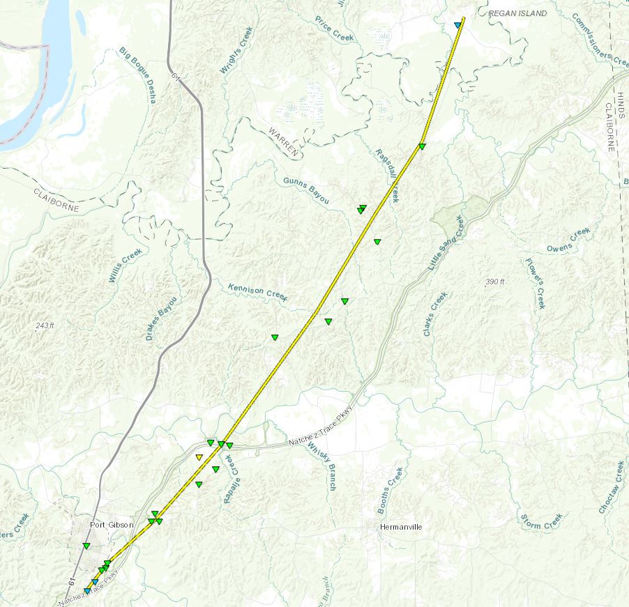
Track Summary This tornado touched down on the southeast side of Port Gibson, near the Natchez Trace Parkway. As the tornado tracked north-northeast, it snapped hardwood trees and uprooted numerous trees. One tree fell on a house on Smith Street, causing roof damage. The tornado then tracked toward the northeast, crossing the Natchez Trace Parkway and Highway 18. Here it continued to snap or uproot trees and also caused roof damage to a structure. The tornado crossed the Natchez Trace Parkway again, snapping or blowing down numerous trees. As the tornado tracked northeast, it crossed Old Port Gibson Road, Hankinson Road, and Moulder Road where it continued to snap or uproot numerous trees. The tornado finally lifted near Fisher Ferry Road in southern Warren County. A tornado debris signature was noted on radar during this tornado. |
|
Radar Imagery
These images from the Brandon, MS radar show the storm at 7:32 am as the tornado moved through the east side of Port Gibson. The image on the left shows 0.5° base reflectivity data, and the image on the right shows 0.5° storm relative velocity data. Click on the thumbnail below for a higher resolution image.

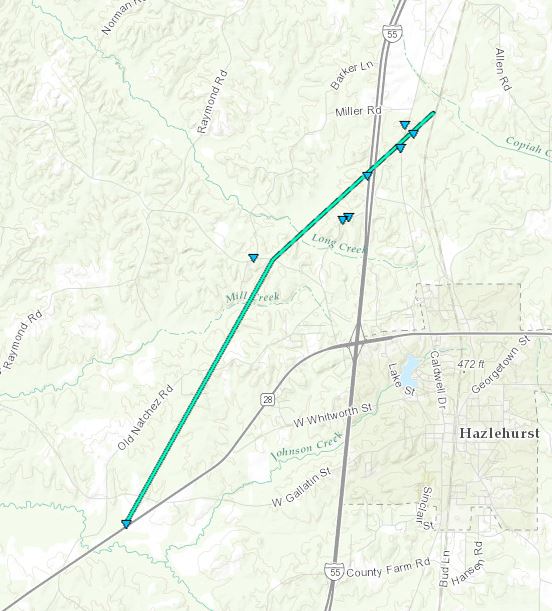
Northwest Hazlehurst EF-0 Tornado
Click on map above to see entire damage point notation and damage pictures at select points.
|
Track Summary This tornado touched down along Highway 28, uprooting some trees and snapping large limbs. It continued northeast, crossing Dentville Road and Welch Lane before crossing I-55. Many trees were uprooted along the path. The tornado then crossed US-51, uprooting some trees and snapping some large limbs. It continued just northeast into a wooded area, where some trees were uprooted, before lifting. |
|
Radar Imagery
These images from the Brandon, MS radar show the storm at 8:04 am as the tornado passed on the northwest side of Hazlehurst. The image on the left shows 0.5° base reflectivity data, and the image on the right shows 0.5° storm relative velocity data. Click on the thumbnail below for a higher resolution image.

Click on map above to see entire damage point notation and damage pictures at select points.
|
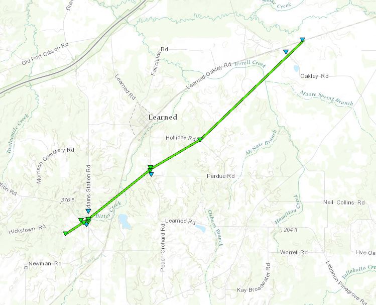
Track Summary This tornado touched down just SW of the intersection of Adams Station Road and Old Adams Station Road. Here, heavy tree damage was noted as dozens of trees were snapped/uprooted. A power line was down here as well. The tornado then crossed Learned Road, just S of Learned, and damaged dozens of trees. The tornado continued NE and crossed Holiday Road where tree damage was noted. The tornado had weakened by this point. The tornado tracked over some pasture and farm land and dissipated as it crossed Oakley Road. |
|
Radar Imagery
These images from the Brandon, MS radar show the storm at 8:12 am as it passed near Learned. The image on the left shows 0.5° base reflectivity data, and the image on the right shows 0.5° storm relative velocity data. Click on the thumbnail below for a higher resolution image.

Click on map above to see entire damage point notation and damage pictures at select points.
|
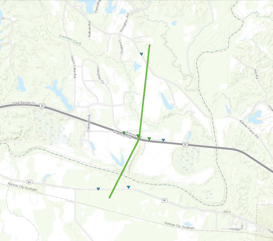
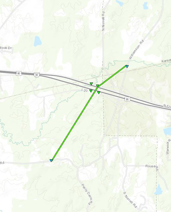
Track Summary This tornado started just south of Hwy 80 just to the west of Edwards where large tree branches were broken and a few trees uprooted. The tornado traveled north and reached its peak intensity and width as it crossed I-20 where hardwood trees were uprooted. The tornado continued north across Armory Road and Freetown Road snapping additional large tree branches before dissipating on the north side of Freetown Road. |
|
Radar Imagery
These images from the Brandon, MS radar show the storm at 8:16 am as it passed near Edwards. The image on the left shows 0.5° base reflectivity data, and the image on the right shows 0.5° storm relative velocity data. Click on the thumbnail below for a higher resolution image.

Click on map above to see entire damage point notation and damage pictures at select points.
|
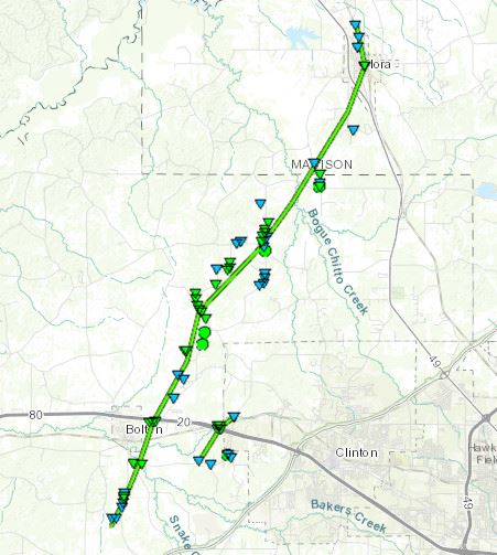
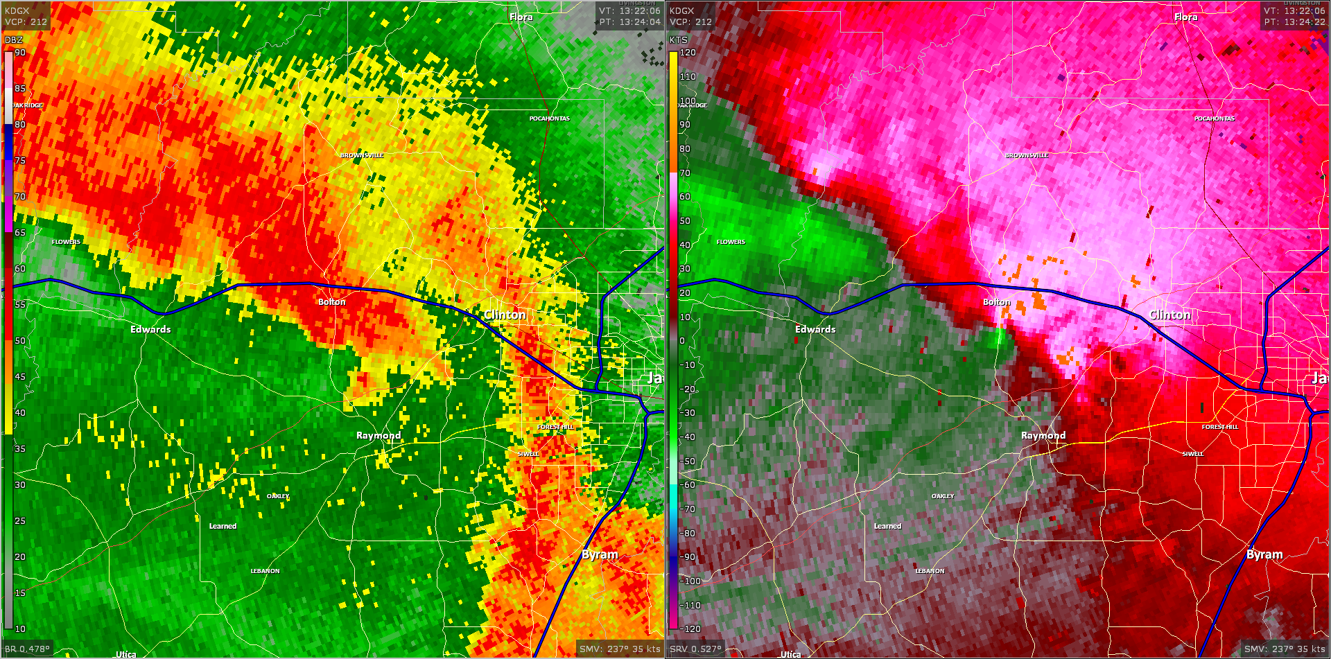
Track Summary |
|
Radar Imagery
These images from the Brandon, MS Doppler radar show the storm at 8:24 am as the tornado was on the south side of Bolton. The image on the left shows 0.5° base reflectivity data, and the image on the right shows 0.5° storm relative velocity data. Click on the thumbnail below for a higher resolution image.
Click on map above to see entire damage point notation and damage pictures at select points.
|
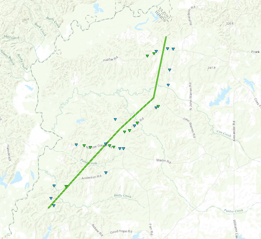
Track Summary This tornado started just west of the intersection of Anderson Road and Askew Road where large limbs were snapped and a few trees uprooted. The tornado crossed Anderson Road again as it continued moving northeast. The tornado widened as it crossed Narrow Gauge Road where hardwood and softwood trees were snapped and uprooted. The tornado paralleled Farr Road where additional limbs were snapped and trees uprooted. The tornado reached its peak intensity along Farr road near the intersection of John Warren Road where numerous hardwood trees were snapped and uprooted. The tornado then took a slight northwest turn and continued to parallel Farr Road causing more tree damage before dissipating shortly after crossing Halifax Road. |
|
Radar Imagery
These images from the Brandon, MS radar show the storm at 8:30 am as it passed northwest of Edwards in northwest Hinds County. The image on the left shows 0.5° base reflectivity data, and the image on the right shows 0.5° storm relative velocity data. Click on the thumbnail below for a higher resolution image.

Click on map above to see entire damage point notation and damage pictures at select points.
|
Track Summary |
|
Radar Imagery
These images from the Brandon, MS Doppler radar show the storm at 8:24 am as the tornado tracked west of Terry. The image on the left shows 0.5° base reflectivity data, and the image on the right shows 0.5° storm relative velocity data. Click on the thumbnail below for a higher resolution image.

Click on map above to see entire damage point notation and damage pictures at select points.
|
Track Summary |
|
Radar Imagery
These images from the Brandon, MS Doppler radar show the storm at 8:26 am just before the tornado began south of I-20 between Bolton and Clinton. The image on the left shows 0.5° base reflectivity data, and the image on the right shows 0.5° storm relative velocity data. Click on the thumbnail below for a higher resolution image.

Click on map above to see entire damage point notation and damage pictures at select points.
|
Track Summary |
|
Radar Imagery
These images from the Brandon, MS Doppler radar show the storm at 8:50 am just as the tornado touched down just south of Kearney Park. The image on the left shows 0.5° base reflectivity data, and the image on the right shows 0.5° storm relative velocity data. Click on the thumbnail below for a higher resolution image.
Click on map above to see entire damage point notation and damage pictures at select points.
|
Track Summary |
|
Radar Imagery
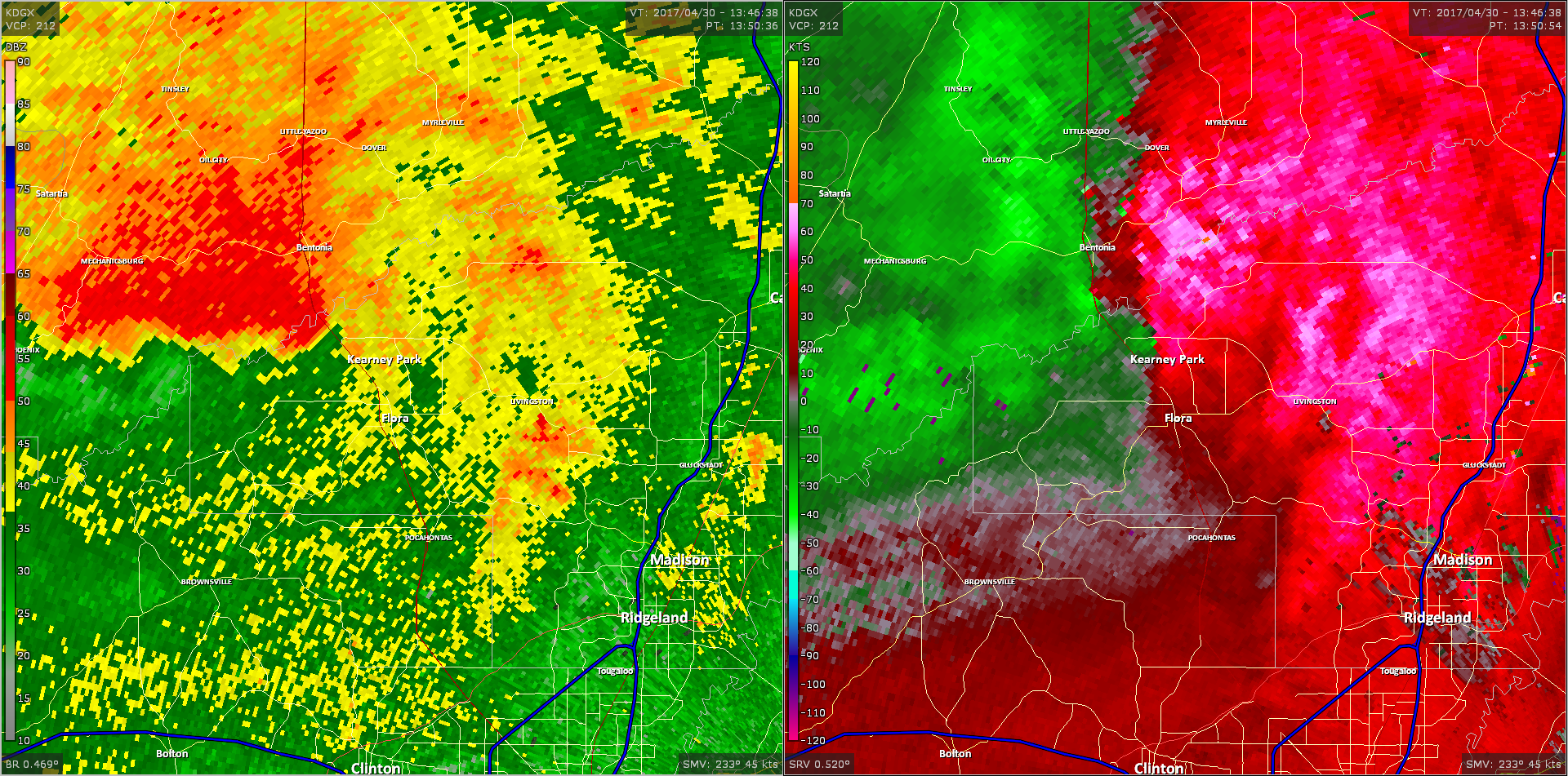
These images from the Brandon, MS Doppler radar show the storm at 8:52 am just as the tornado passed southeast of Bentonia in southern Yazoo County along the Big Black River. The image on the left shows 0.5° base reflectivity data, and the image on the right shows 0.5° storm relative velocity data. Click on the thumbnail below for a higher resolution image.

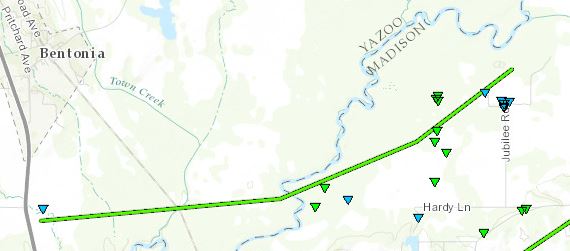
Southeast Yazoo County EF-2 Tornado
Click on map above to see entire damage point notation and damage pictures at select points.
|
Track Summary |
|
Radar Imagery
These images from the Brandon, MS Doppler radar show the storm at 9:00 am just as the tornado passed southeast of Myrleville. The image on the left shows 0.5° base reflectivity data, and the image on the right shows 0.5° storm relative velocity data. Click on the thumbnail below for a higher resolution image.

Click on map above to see entire damage point notation and damage pictures at select points.
|
Track Summary |
|
Radar Imagery
These images from the Brandon, MS Doppler radar show the storm at 9:10 am just as the tornado passed through the Linwood community. The image on the left shows 0.5° base reflectivity data, and the image on the right shows 0.5° storm relative velocity data. Click on the thumbnail below for a higher resolution image.

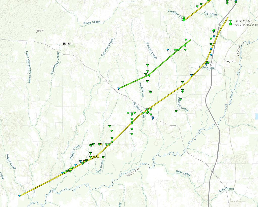
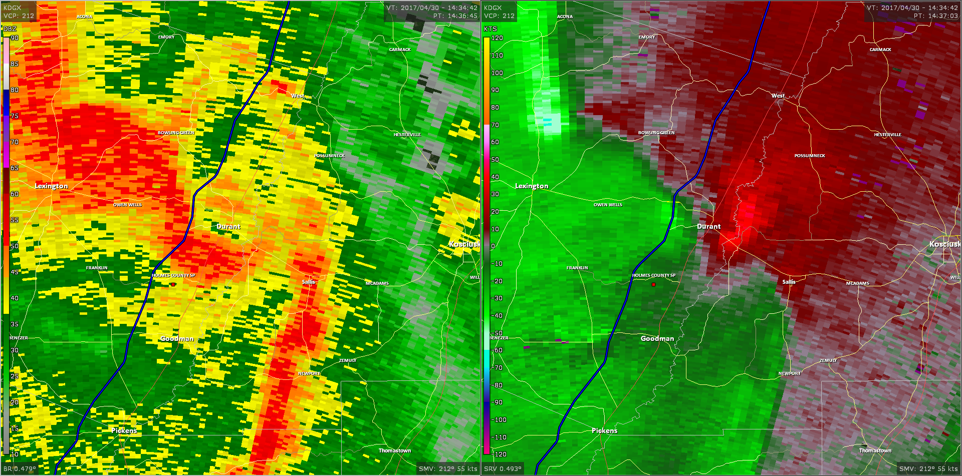
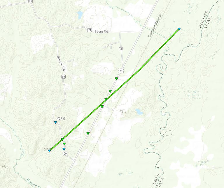
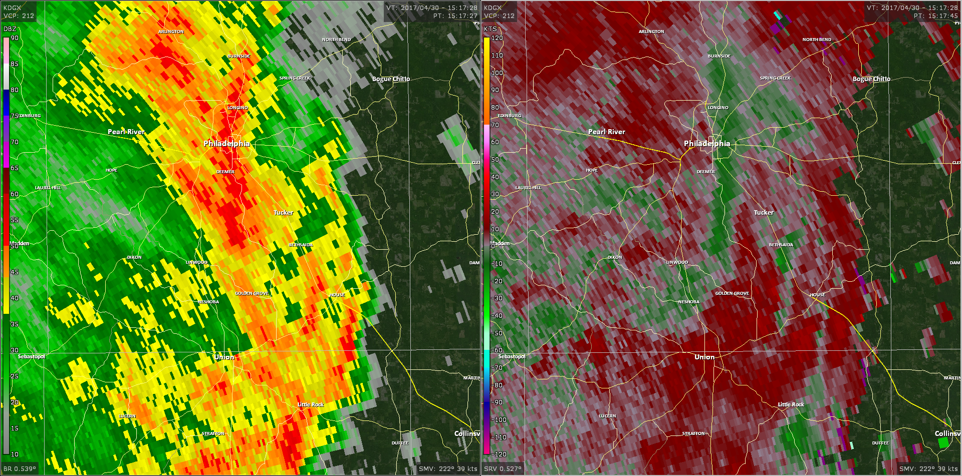
Pickens/Goodman/Durant EF-2 Tornado
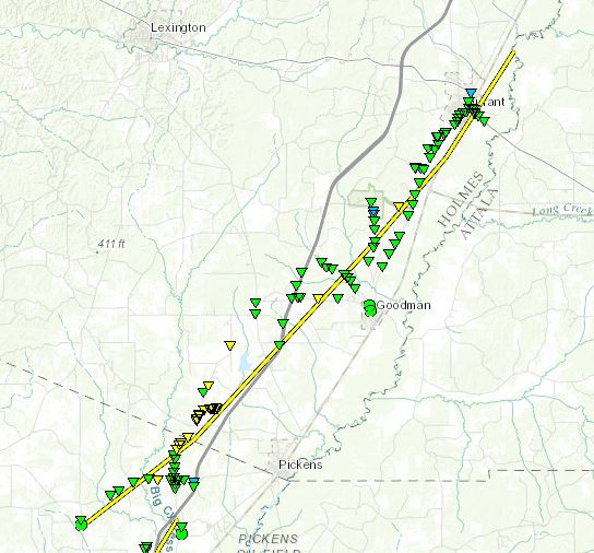
Click on map above to see entire damage point notation and damage pictures at select points.
|
Track Summary |
|
Radar Imagery
These images from the Brandon, MS Doppler radar show the storm at 9:37 am as the tornado tore through the city of Durant. The image on the left shows 0.5° base reflectivity data, and the image on the right shows 0.5° storm relative velocity data. Click on the thumbnail below for a higher resolution image.
Emory (Holmes/Carroll Co) EF-1 Tornado
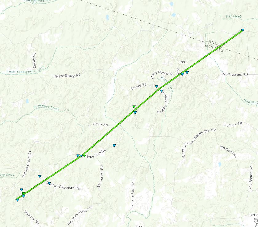
Click on map above to see entire damage point notation and damage pictures at select points.
|
Track Summary The tornado began just to the southwest of Sudbeck Road and downed hardwood trees in this area. It then continued northeast snapping tree limbs and uprooting a few trees along its path in the northern part of Holmes County. The tornado then crossed into Carroll County and dissipated along Highway 37. |
|
Radar Imagery
These images from the Brandon, MS Doppler radar show the storm at 9:41 am as the tornado tore through northern Holmes County. The image on the left shows 0.5° base reflectivity data, and the image on the right shows 0.5° storm relative velocity data. Click on the thumbnail below for a higher resolution image.

East Scott County EF-0 Tornado
Click on map above to see entire damage point notation and damage pictures at select points.
|
Track Summary |
|
Radar Imagery
These images from the Brandon, MS Doppler radar show the storm at 9:45 am as the tornado tore through eastern Scott County. The image on the left shows 0.5° base reflectivity data, and the image on the right shows 0.5° storm relative velocity data. Click on the thumbnail below for a higher resolution image.

Northeast Holmes County/Hoffman EF-1 Tornado
Click on map above to see entire damage point notation and damage pictures at select points.
|
Track Summary |
|
Radar Imagery
These images from the Brandon, MS Doppler radar show the storm at 9:43 am near the time the tornado crossed US 51. The image on the left shows 0.5° base reflectivity data, and the image on the right shows 0.5° storm relative velocity data. Click on the thumbnail below for a higher resolution image.

Northwest Attala County/Possumneck EF-1 Tornado
Click on map above to see entire damage point notation and damage pictures at select points.
|
Track Summary |
|
Radar Imagery
These images from the Brandon, MS Doppler radar show the storm at 9:45 am as the tornado moved across northwest Attala County. The image on the left shows 0.5° base reflectivity data, and the image on the right shows 0.5° storm relative velocity data. Click on the thumbnail below for a higher resolution image.
Click on map above to see entire damage point notation and damage pictures at select points.
|
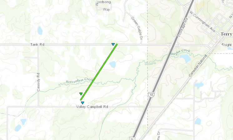
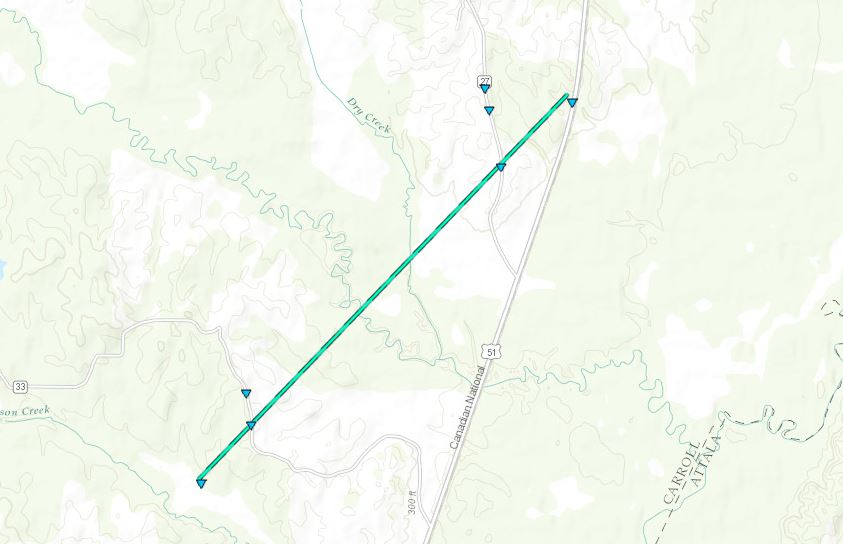
Track Summary The tornado began near Hudson Creek in southern Carroll County. As it tracked north northeast toward Beatty, it uprooted trees and downed some powerlines along County Rd 33. As it crossed County Rd 27, it continued to uproot some softwood trees and tore a few shingles off of a home. The tornado dissipated along Highway 51 north of Beatty.
|
|
Radar Imagery
These images from the Brandon, MS Doppler radar show the storm at 9:51 am right as the tornado touched down near Hudson Creek. The image on the left shows 0.5° base reflectivity data, and the image on the right shows 0.5° storm relative velocity data. Click on the thumbnail below for a higher resolution image.

Click on map above to see entire damage point notation and damage pictures at select points.
|
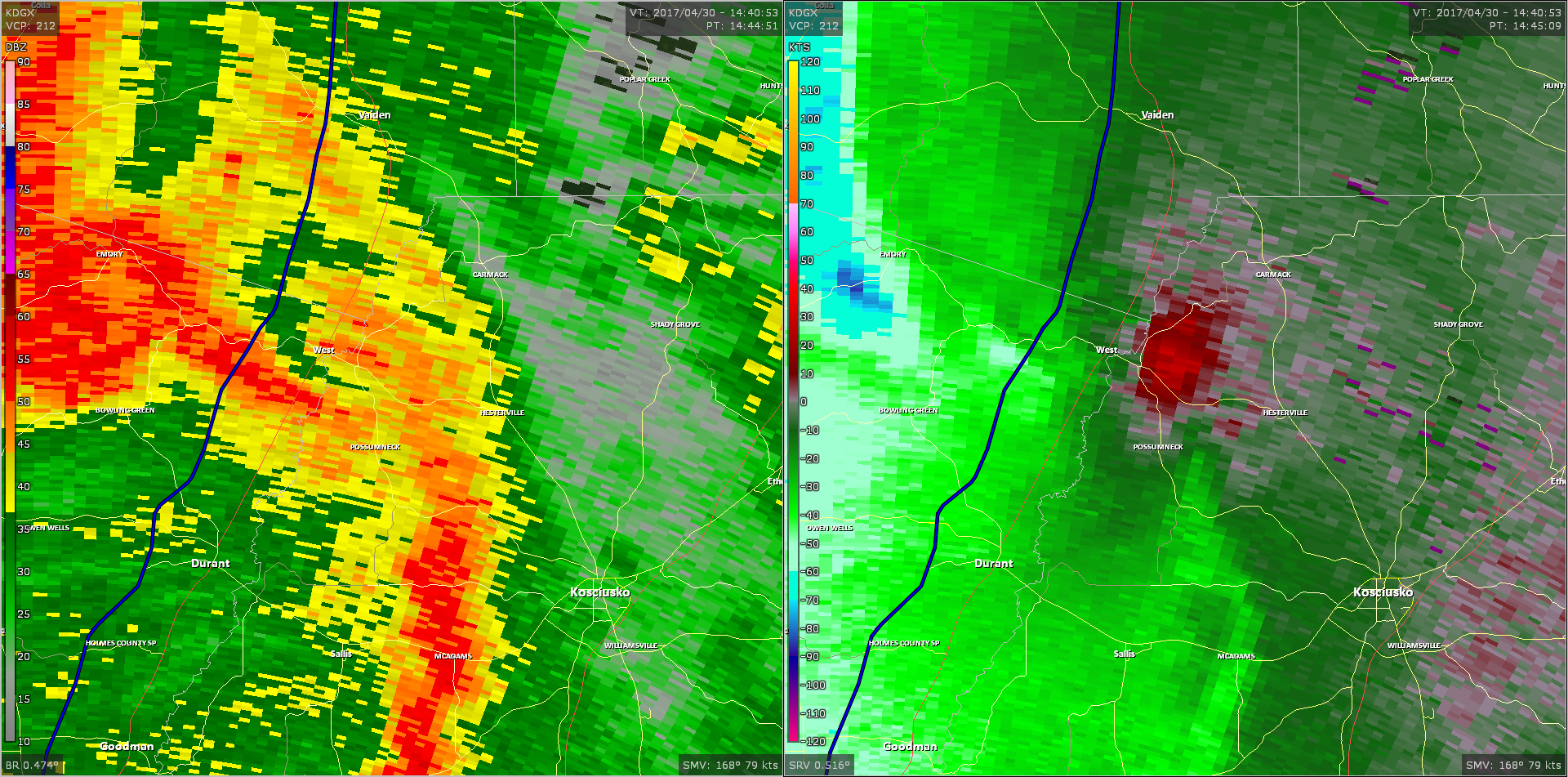
Track Summary This tornado started on the south side of Vaiden and tracked northeast, dissipating just to the northwest of Kilmichael. Initially, trees were snapped and uprooted along CR 28 and CR 27. The tornado then crossed Highway 51 where numerous trees were snapped or uprooted and power lines were downed. A few homes sustained minor roof damage and one had a large tree down on it. The railroad was blocked by several trees as well. The tornado then crossed Highway 35 where more trees were damaged. It then moved into a wooded area and mostly tracked south of Highway 430. A few damage locations were accessible along CR 9 where more trees were downed, but the road was blocked and the core of the tornado path was inaccessible. The northwest edge of the tornado began to impact portions of Highway 430 a few miles before the junction with Highway 407. Here numerous trees were damaged. The tornado appeared to peak in intensity and reach its widest point near the Carroll/Montgomery County line and along Highway 407. Here, significant tree damage was noted as the tornado moved across an open field and slammed into a wooded area. Significant tree damage was noted across the field south of the highway and where it crossed Highway 407. Widespread tree damage continued across Herring Loop, Lower Bethlehem Road, and Herring School Road. Some homes were damaged by trees. Along Herring School Road, a couple sheds were destroyed along with several homes sustaining minor roof damage. A large metal I-beam shed was destroyed and thrown nearly 100 yards. As the tornado neared Kindred Road, a turn to the left was noted and it began to track more northerly. Damage to trees continued as it crossed Lewis Creek Road along with a few sheds damaged and shingles off roofs. As it crossed Highway 82 west of Kilmichael, more trees were downed along with a dozen or so power poles. Three homes had roof damage and several sheds had tin off the roof. The tornado continued just a bit farther north and dissipated just past the intersection of Mayfield and Robinson-Thompson Road. |
|
Radar Imagery
These images from the Brandon, MS Doppler radar show the storm at 10:05 am right as the tornado crossed the Carroll/Montgomery county line. The image on the left shows 0.5° base reflectivity data, and the image on the right shows 0.5° storm relative velocity data. Click on the thumbnail below for a higher resolution image.

Click on map above to see entire damage point notation and damage pictures at select points.
|
Track Summary This tornado started on the south side of Vaiden and tracked northeast, dissipating just to the northwest of Kilmichael. Initially, trees were snapped and uprooted along CR 28 and CR 27. The tornado then crossed Highway 51 where numerous trees were snapped or uprooted and power lines were downed. A few homes sustained minor roof damage and one had a large tree down on it. The railroad was blocked by several trees as well. The tornado then crossed Highway 35 where more trees were damaged. It then moved into a wooded area and mostly tracked south of Highway 430. A few damage locations were accessible along CR 9 where more trees were downed, but the road was blocked and the core of the tornado path was inaccessible. The northwest edge of the tornado began to impact portions of Highway 430 a few miles before the junction with Highway 407. Here numerous trees were damaged. The tornado appeared to peak in intensity and reach its widest point near the Carroll/Montgomery County line and along Highway 407. Here, significant tree damage was noted as the tornado moved across an open field and slammed into a wooded area. Significant tree damage was noted across the field south of the highway and where it crossed Highway 407. Widespread tree damage continued across Herring Loop, Lower Bethlehem Road, and Herring School Road. Some homes were damaged by trees. Along Herring School Road, a couple sheds were destroyed along with several homes sustaining minor roof damage. A large metal I-beam shed was destroyed and thrown nearly 100 yards. As the tornado neared Kindred Road, a turn to the left was noted and it began to track more northerly. Damage to trees continued as it crossed Lewis Creek Road along with a few sheds damaged and shingles off roofs. As it crossed Highway 82 west of Kilmichael, more trees were downed along with a dozen or so power poles. Three homes had roof damage and several sheds had tin off the roof. The tornado continued just a bit farther north and dissipated just past the intersection of Mayfield and Robinson-Thompson Road. |
|
Radar Imagery
These images from the Brandon, MS Doppler radar show the storm at 10:05 am right as the tornado crossed the Carroll/Montgomery county line. The image on the left shows 0.5° base reflectivity data, and the image on the right shows 0.5° storm relative velocity data. Click on the thumbnail below for a higher resolution image.
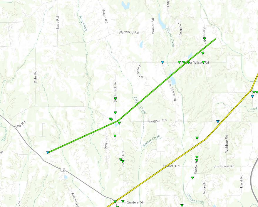
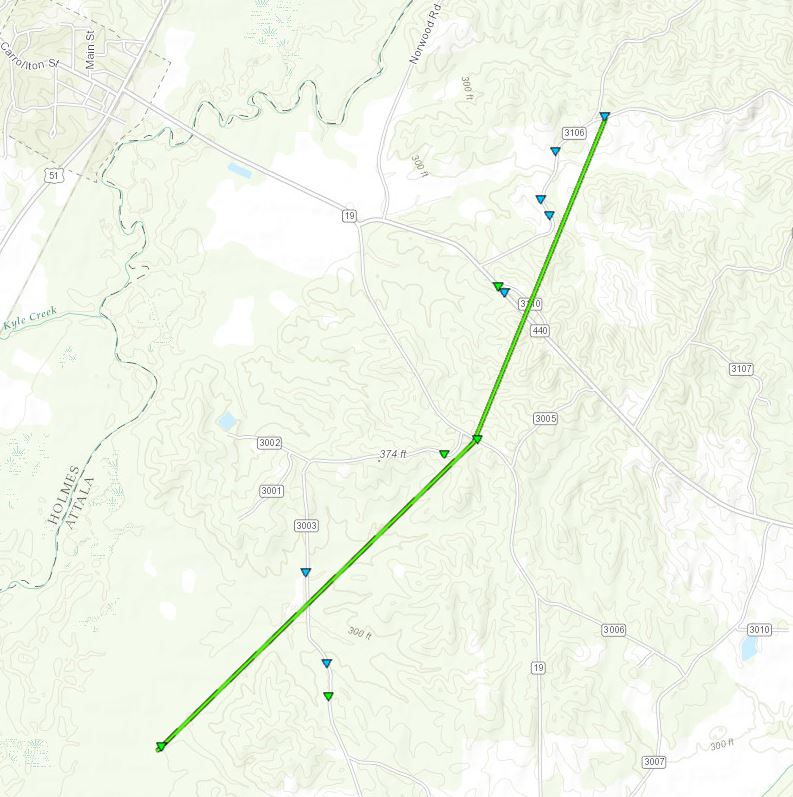
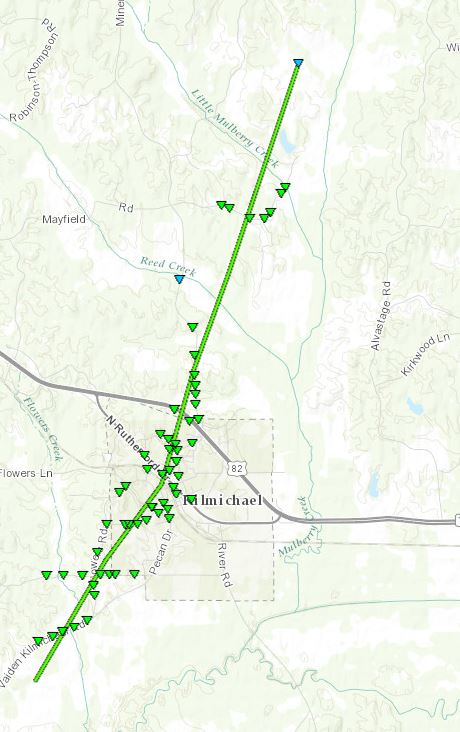
Montgomery County/Lodi Road EF-1 Tornado
Click on map above to see entire damage point notation and damage pictures at select points.
|
Track Summary The tornado began south of Robinson-Thompson Road. As it tracked northeast, it snapped and uprooted many softwood and hardwood trees along its path. It dissipated along Oak Ridge Road. |
|
Radar Imagery
These images from the Brandon, MS Doppler radar show the storm at 10:13 am as the tornado tracked north of Kilmichael. The image on the left shows 0.5° base reflectivity data, and the image on the right shows 0.5° storm relative velocity data. Click on the thumbnail below for a higher resolution image.

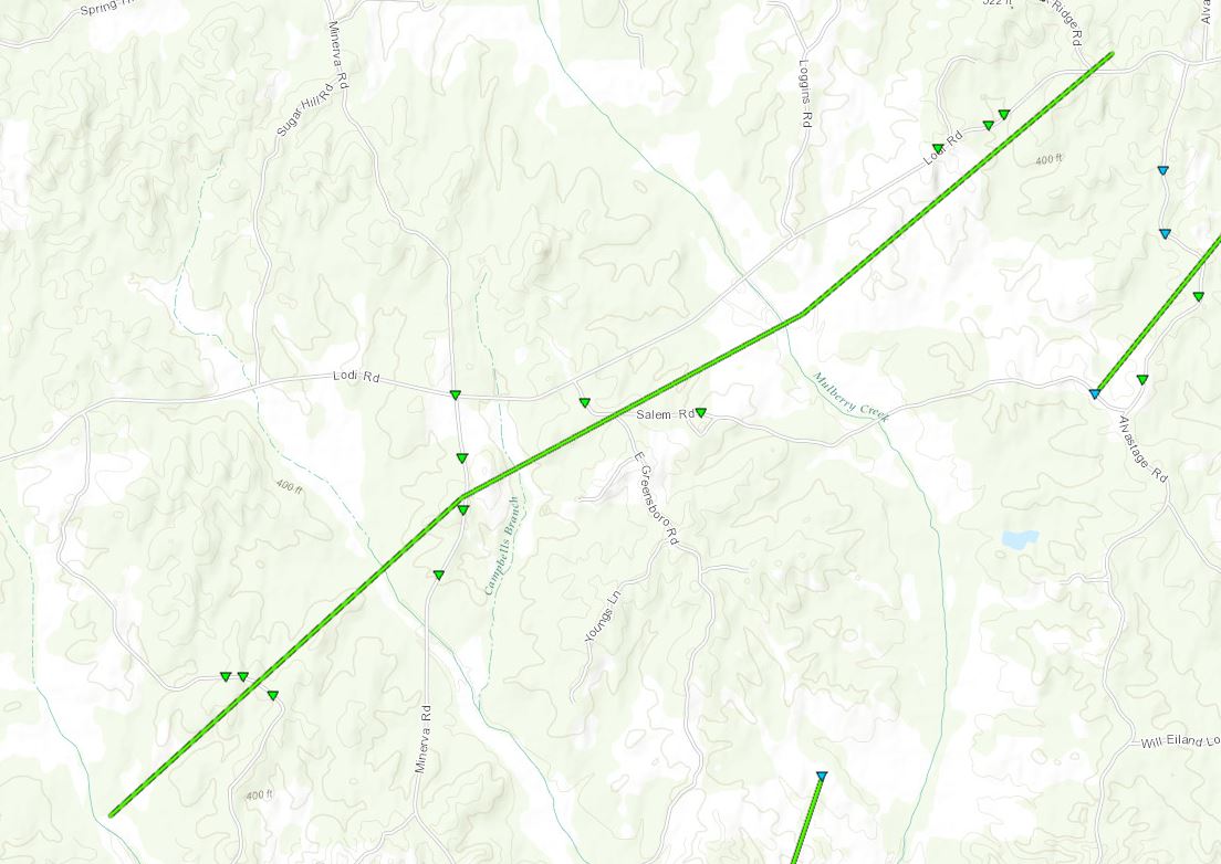
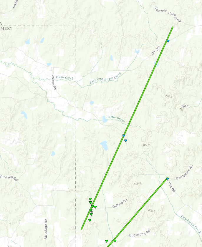
Montgomery/Webster County EF-1
Click on map above to see entire damage point notation and damage pictures at select points.
|
Track Summary The tornado began along Salem Road and tracked to the northeast. As it did, it snapped and uprooted numerous trees along its path. It crossed into Webster County along Lodi Road and continued to cause mostly tree damage. It dissipated near the intersection of Alva Road and Dan Moore Road. |
|
Radar Imagery
These images from the Brandon, MS Doppler radar show the storm at 10:18 am as the tornado tracked southeast of the Alva community. The image on the left shows 0.5° base reflectivity data, and the image on the right shows 0.5° storm relative velocity data. Click on the thumbnail below for a higher resolution image.

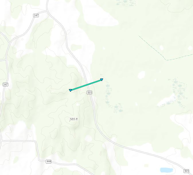
Click on map above to see entire damage point notation and damage pictures at select points.
|
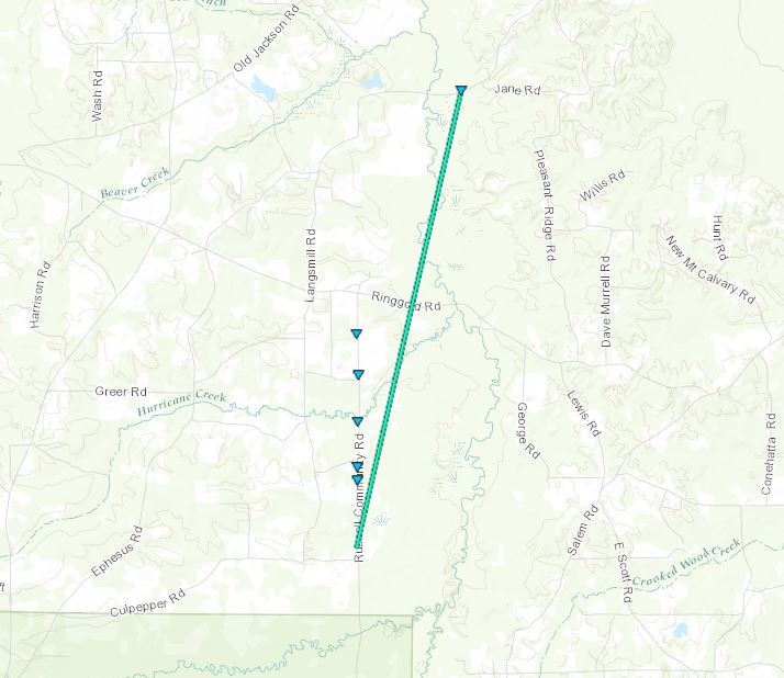
Track Summary The tornado touched down just southwest of County Road 505. Along this road it snapped a few softwood trees, one of which fell onto a powerline. A flag pole was also bent in half. It also caused damage to the skirting of a mobile home of a storm spotter, who observed this tornado. The tornado crossed this road and lifted in a field to the northeast. |
|
Radar Imagery
These images from the Brandon, MS Doppler radar show the storm at 10:17 am as the tornado briefly touched down southwest of Tucker. The image on the left shows 0.5° base reflectivity data, and the image on the right shows 0.5° storm relative velocity data. Click on the thumbnail below for a higher resolution image.
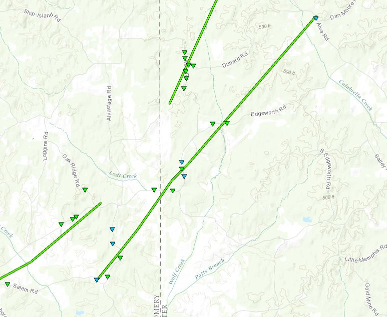
Webster County/Spring Hill EF-1 Tornado
Click on map above to see entire damage point notation and damage pictures at select points.
|
Track Summary This tornado began south of King Road near the Montgomery and Webster county line. Here, it was its most intense and caused significant tree damage by uprooting many hardwood trees along both King and Dubard roads. It then tracked northeast and turned slightly more north. It continued to cause mostly tree damage along its path. The tornado ended just as it crossed Highway 404. |
|
Radar Imagery
These images from the Brandon, MS Doppler radar show the storm at 10:25 am shortly after the tornado lifted west of Spring Hill. The image on the left shows 0.5° base reflectivity data, and the image on the right shows 0.5° storm relative velocity data. Click on the thumbnail below for a higher resolution image.

East Lowndes County EF-1 Tornado
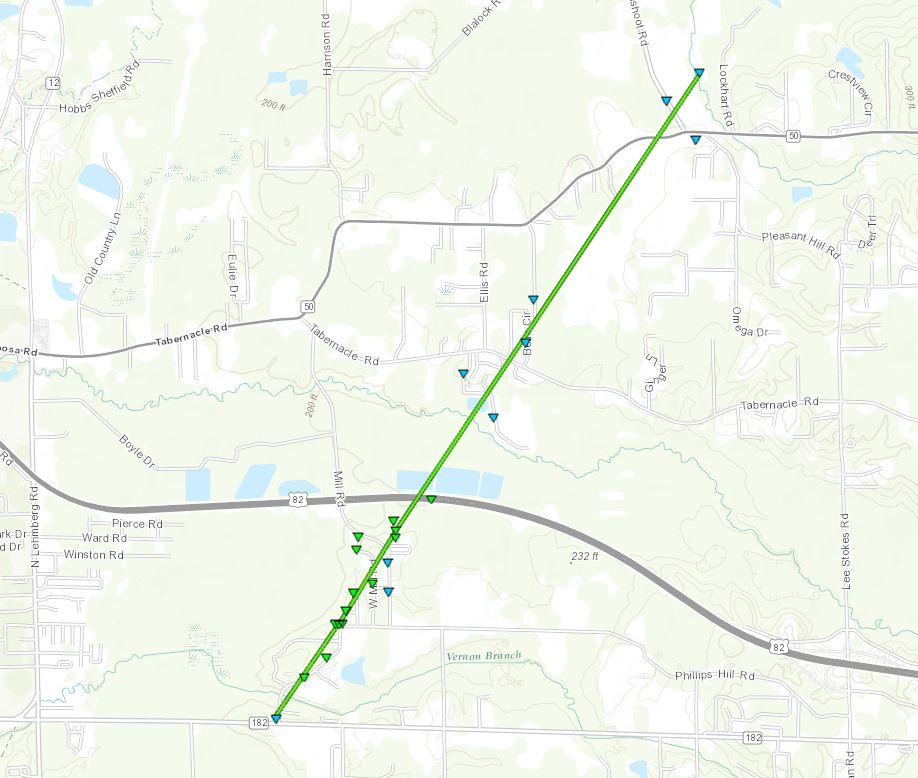
Click on map above to see entire damage point notation and damage pictures at select points.
|
Track Summary This tornado began along Highway 182 and snapped softwood and hardwood trees as it tracked to the north-northeast along Phillips Hill Road. One large tree fell onto a house and destroyed the house. The tornado then tracked across Mill Road and caused roof damage to a home. Near the intersection of Mill Road and West Mill Road, there was roof damage to another home, broken power poles and several trees snapped. As the tornado near Highway 82, it caused damage to a scoreboard at a local park. It crossed Highway 82, snapping a few trees. The tornado continued over Elise Lane and Jamac Road. It then crossed Tabernacle Road, Bell Circle and Honeysuckle Drive before crossing Highway 50, Gunshoot Road and near Pleasant Hill Road, knocking down trees along the path. It lifted shortly after crossing Gunshoot Road. |
|
Radar Imagery
These images from the Columbus AFB, MS radar show the storm at 11:39 am as the tornado moved across Highway 82. The image on the left shows 0.5° base reflectivity data, and the image on the right shows 0.5° storm relative velocity data. Click on the thumbnail below for a higher resolution image.


