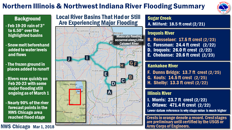
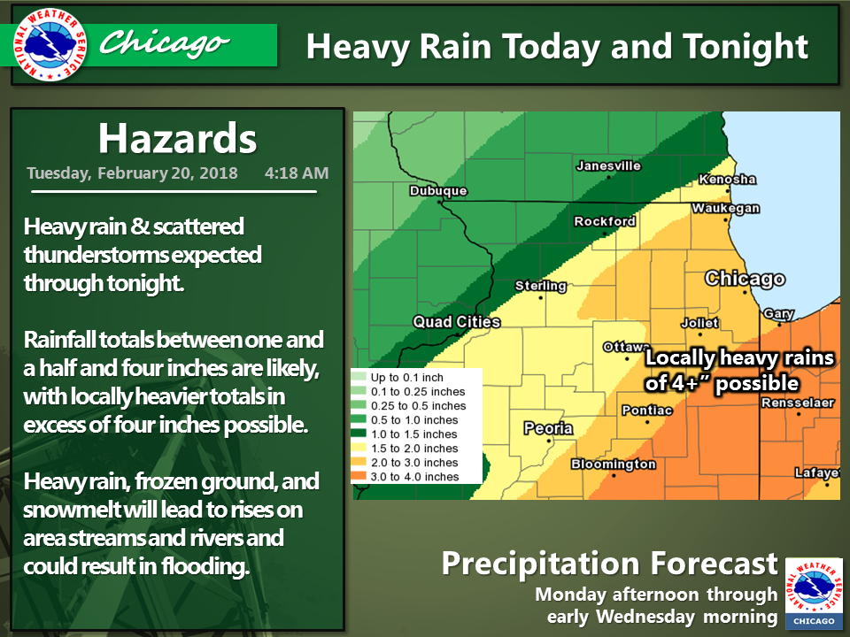
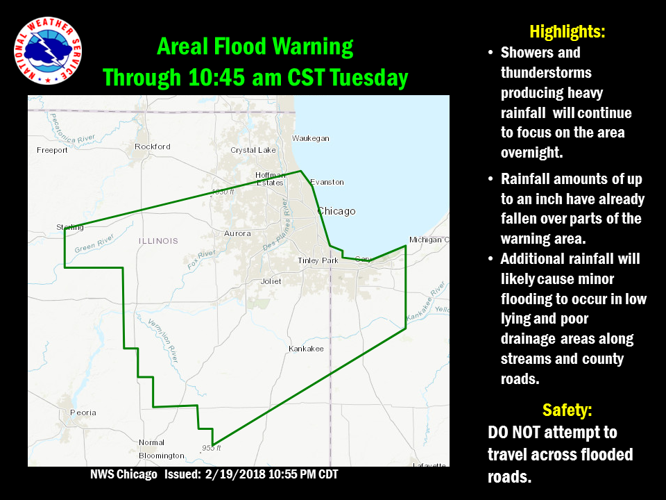
Overview
|
Fast Facts/Records Set:
|
|
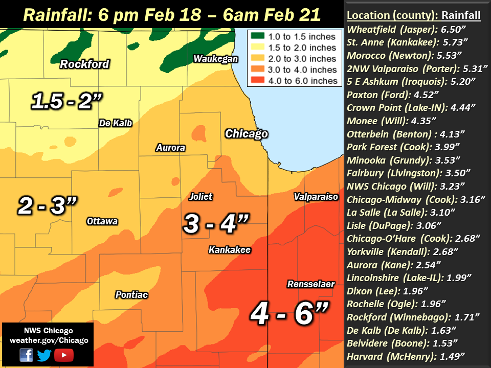
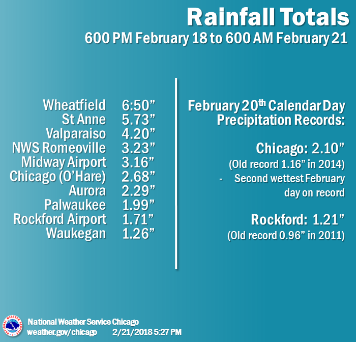
Observed Rainfall
 |
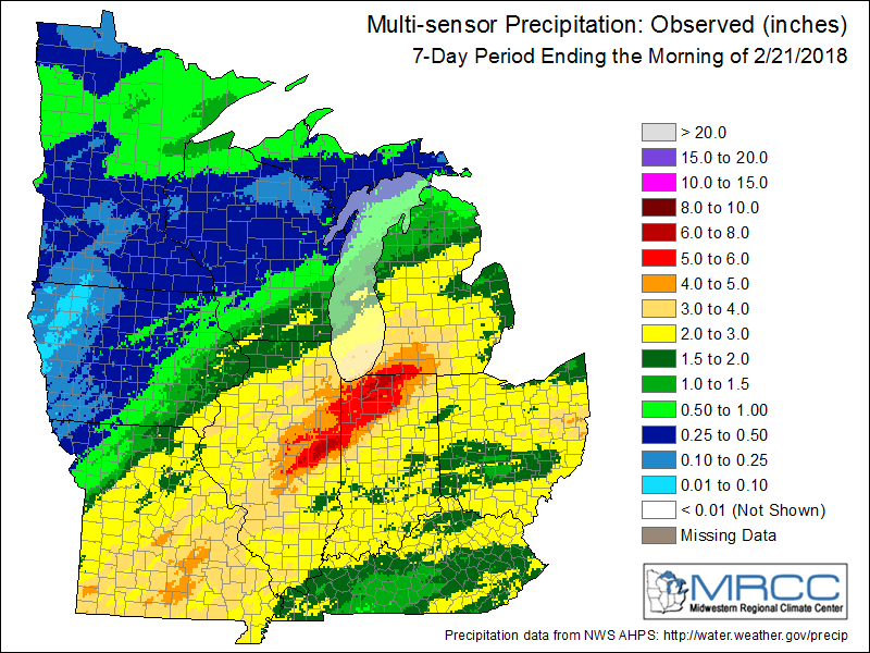 |
| Feb 18-21, 2018 local area rainfall | Weekly Midwest rainfall ending Feb 21, 2018 (courtesy of the MRCC) |
Public Information Statement
National Weather Service Chicago/Romeoville IL
0320 PM CST Wed Feb 21 2018

...3-Day Rainfall Round-Up...

The following are rainfall amounts for the previous 3 days
as measured in the morning by NWS Cooperative Observers
and CoCoRaHS observers. Observations are usually
taken between 6 AM and 8 AM. Thank you to all the observers
who provided rainfall reports for this historic event.

  3-day rain totals for Wednesday (02/21/18)
     as of 02:59 PM CST

ILLINOIS                                 3-Day Rainfall
  Location (County):                         Amt(Inches) Reports

  St Anne (Kankakee)...........................5.73     (3)
  Ashkum 5.6E (Iroquois).......................5.20     (3)
  Watseka 6.9WNW (Iroquois)....................4.74     (3)
  Crete 3E (Will)..............................4.56     (3)
  Paxton (Ford)................................4.52     (3)
  Momence (Kankakee)...........................4.26     (3)
  Paxton (Ford)................................4.25     (3)
  Wilmington 3SE (Will)........................4.20     (3)
  Watseka (Iroquois)...........................4.17     (3)
  Cissna Park 1S (Iroquois)....................4.17     (2)
  Peotone (Will)...............................4.10     (3)
  Streator 1WSW (La Salle).....................4.07     (3)
  Park Forest 1NNE (Cook)......................3.99     (3)
  Chicago 6ESE (Cook)..........................3.91     (2)
  Gibson 3WNW (Ford)...........................3.89     (3)
  Manhattan 2SE (Will).........................3.88     (2)
  Manhattan 1ESE (Will)........................3.85     (3)
  Manhattan (Will).............................3.82     (3)
  Manhattan 5ENE (Will)........................3.82     (3)
  Beecher 3SSE (Will)..........................3.79     (3)
  New Lenox 3E (Will)..........................3.76     (3)
  Coal City 3N (Grundy)........................3.69     (3)
  Marseilles (La Salle)........................3.67     (3)
  Morris 6ESE (Grundy).........................3.67     (3)
  Midlothian (Cook)............................3.64     (3)
  Lansing (Cook)...............................3.63     (3)
  New Lenox 2SE (Will).........................3.59     (3)
  Joliet 2n (Will).............................3.58     (3)
  Chicago Ridge (Cook).........................3.56     (2)
  Carbon Hill 3.1N (Grundy)....................3.56     (3)
  Coal City 4NNW (Grundy)......................3.56     (3)
  Midway Coop (Cook)...........................3.55     (3)
  Willow Springs (Cook)........................3.54     (3)
  Minooka (Grundy).............................3.53     (3)
  Plainfield 2SSE (Will).......................3.52     (3)
  Oak Lawn 2WNW (Cook).........................3.51     (3)
  Channahon 2SSE (Will)........................3.51     (2)
  Fairbury (Livingston)........................3.50     (2)
  Streator 4ENE (La Salle).....................3.49     (3)
  Morris 2SSE (Grundy).........................3.46     (3)
  Palos Park 1SW (Cook)........................3.46     (3)
  Lockport 1SE (Will)..........................3.45     (3)
  Countryside 1ENE (Cook)......................3.45     (3)
  New Lenox 4SE (Will).........................3.41     (3)
  Oak Lawn 2SE (Cook)..........................3.40     (2)
  Kankakee (Kankakee)..........................3.36     (3)
  Homewood (Cook)..............................3.35     (3)
  Park Forest (Cook)...........................3.33     (3)
  Oak Lawn 2NW (Cook)..........................3.30     (2)
  Buckley (Iroquois)...........................3.29     (2)
  Burr Ridge 2SW (Du Page).....................3.29     (3)
  Romeoville (Will)............................3.23     (3)
  La Grange Park 1SSW (Cook)...................3.23     (2)
  Worth (Cook).................................3.22     (3)
  Somonauk 2NE (De Kalb).......................3.22     (3)
  Streator (Livingston)........................3.21     (3)
  Joliet Lock/dam (Will).......................3.20     (3)
  Oak Lawn (Cook)..............................3.17     (2)
  Midway (Cook)................................3.16     (3)
  Plainfield (Will)............................3.15     (3)
  La Salle (La Salle)..........................3.10     (3)
  Morris (Grundy)..............................3.10     (3)
  Wheaton 2NNE (Du Page).......................3.09     (3)
  Downers Grove 0.4NNE (Du Page)...............3.08     (3)
  Lisle Morton Arb (Du Page)...................3.06     (3)
  Naperville 1NW (Du Page).....................3.05     (3)
  Dwight 4NNW (Grundy).........................3.04     (2)
  Plainfield 3ESE (Will).......................3.03     (2)
  Oak Park 2S (Cook)...........................3.00     (2)
  Dwight (Livingston)..........................2.96     (3)
  Peru 1ENE (La Salle).........................2.93     (3)
  Elmhurst 2SE (Du Page).......................2.91     (3)
  Bridgeview 1NNW (Cook).......................2.90     (3)
  Lincolnwood 3E (Cook)........................2.89     (2)
  Herscher 3E (Kankakee).......................2.88     (3)
  Elmhurst 1ESE (Du Page)......................2.87     (3)
  Woodstock 5nw (McHenry)......................2.86     (3)
  Aurora 4SE (Du Page).........................2.84     (3)
  Ravenswood Manor (Cook)......................2.84     (2)
  Westmont (Du Page)...........................2.82     (2)
  Morris (Grundy)..............................2.82     (3)
  Lansing (Cook)...............................2.81     (3)
  Ottawa 2N (La Salle).........................2.78     (3)
  Roselle 1ESE (Du Page).......................2.78     (3)
  Oak Park 1NNE (Cook).........................2.78     (3)
  Pontiac 1ESE (Livingston)....................2.76     (2)
  Bonfield 4WSW (Kankakee).....................2.76     (3)
  Lincolnwood 2E (Cook)........................2.75     (3)
  Harwood Heights (Cook).......................2.74     (3)
  Batavia (Kane)...............................2.74     (3)
  Rogers Park 2SW (Cook).......................2.73     (3)
  Alsip (Cook).................................2.73     (3)
  North Aurora 2NE (Kane)......................2.71     (3)
  Glen Ellyn 2SSE (Du Page)....................2.70     (3)
  Yorkville 2SE (Kendall)......................2.68     (2)
  Pontiac 1SE (Livingston).....................2.68     (3)
  Park Ridge (Cook)............................2.68     (3)
  Ohare (Cook).................................2.68     (3)
  Chatsworth (Livingston)......................2.66     (2)
  Schaumburg 2E (Cook).........................2.66     (3)
  Chatsworth (Livingston)......................2.66     (2)
  Mazon 0.5ENE (Grundy)........................2.65     (2)
  Park Ridge 1WNW (Cook).......................2.61     (3)
  Riverwoods (Lake)............................2.59     (2)
  Sugar Grove 1NE (Kane).......................2.59     (3)
  Sugar Grove 1ENE (Kane)......................2.56     (3)
  Elk Grove Village 1ESE (Cook)................2.54     (3)
  Aurora (Kane)................................2.54     (3)
  Batavia 1WNW (Kane)..........................2.52     (3)
  Elk Grove Village 2WSW (Cook)................2.51     (3)
  Peru (La Salle)..............................2.50     (3)
  Geneva 1SSW (Kane)...........................2.48     (3)
  Batavia 2WNW (Kane)..........................2.48     (3)
  Joliet (Will)................................2.44     (3)
  River Forest 1SSE (Cook).....................2.42     (2)
  St. Charles (Kane)...........................2.41     (3)
  Palatine 1NNE (Cook).........................2.41     (3)
  Elmhurst (Du Page)...........................2.37     (3)
  Botanic Gardens (Cook).......................2.35     (3)
  Batavia 1WSW (Kane)..........................2.32     (3)
  Earlville 3S (La Salle)......................2.31     (3)
  Aurora (Kane)................................2.29     (3)
  Hoffman Estates 5W (Cook)....................2.28     (3)
  Barrington (Lake)............................2.26     (3)
  Ottawa (La Salle)............................2.24     (3)
  Buffalo Grove 2N (Lake)......................2.21     (3)
  Mendota (La Salle)...........................2.18     (3)
  Bannockburn (Lake)...........................2.18     (2)
  Highwood 1S (Lake)...........................2.16     (2)
  Elburn (Kane)................................2.14     (2)
  Darien (Du Page).............................2.13     (1)
  Elgin 2W (Kane)..............................2.12     (3)
  St. Charles 6NW (Kane).......................2.08     (3)
  Sheridan 3SSE (La Salle).....................2.03     (2)
  Earlville 5NNE (De Kalb).....................2.02     (3)
  Lake Zurich (Lake)...........................2.01     (2)
  Elgin (Kane).................................2.00     (2)
  Wheeling (Cook)..............................1.99     (3)
  Lincolnshire 1N (Lake).......................1.99     (2)
  Ashton (Lee).................................1.98     (3)
  Rochelle (Ogle)..............................1.96     (2)
  Lisle 1SW (Du Page)..........................1.96     (1)
  Dixon (Lee)..................................1.96     (3)
  Oswego 5SSE (Kendall)........................1.95     (2)
  Ottawa 1NW (La Salle)........................1.94     (2)
  Byron 3N (Ogle)..............................1.91     (2)
  Dixon 3NNW (Lee).............................1.86     (2)
  Pontiac (Livingston).........................1.81     (3)
  Paw Paw (Lee)................................1.81     (3)
  Rockford (Winnebago).........................1.71     (2)
  Wonder Lake 1WNW (McHenry)...................1.69     (2)
  Algonquin 1N (McHenry).......................1.65     (3)
  De Kalb 1SW (De Kalb)........................1.63     (3)
  De Kalb (De Kalb)............................1.63     (3)
  Cary (McHenry)...............................1.61     (2)
  Mundelein (Lake).............................1.60     (2)
  Rockford 2ENE (Winnebago)....................1.54     (2)
  Woodstock 4SW (McHenry)......................1.54     (2)
  Genoa (De Kalb)..............................1.53     (2)
  Belvidere (Boone)............................1.53     (2)
  Cary (McHenry)...............................1.52     (2)
  De Kalb (De Kalb)............................1.52     (3)
  Harvard (McHenry)............................1.49     (2)
  Bull Valley 2WNW (McHenry)...................1.48     (2)
  Lake in the Hills 2.5W (McHenry).............1.45     (2)
  Roscoe 2se (Winnebago).......................1.45     (2)
  Roscoe 2ESE (Winnebago)......................1.45     (2)
  Rochelle (Ogle)..............................1.44     (2)
  Crystal Lake 1WSW (McHenry)..................1.44     (2)
  Rockford 1NW (Winnebago).....................1.43     (3)
  Gurnee 2W (Lake).............................1.43     (2)
  Waukegan 2N (Lake)...........................1.43     (2)
  Capron (Boone)...............................1.43     (2)
  Amboy (Lee)..................................1.42     (2)
  Cortland (De Kalb)...........................1.40     (2)
  Sublette (Lee)...............................1.36     (1)
  Machesney Park 3ENE (Winnebago)..............1.33     (2)
  McHenry (McHenry)............................1.32     (2)
  Waukegan (Lake)..............................1.26     (3)
  Sterling 4NE (Lee)...........................1.24     (1)

INDIANA                                    3-Day Rainfall
  Location (County):                         Amt(Inches) Reports

  Wheatfield 3S (Jasper).......................6.50     (3)
  De Motte 1NNW (Jasper).......................6.41     (3)
  De Motte 1SSW (Jasper).......................6.28     (3)
  (w9opr)Wheatfield 1ENE (Jasper)..............6.19     (3)
  De Motte 4SW (Jasper)........................6.13     (3)
  Lake Village (Newton)........................6.11     (3)
  Valparaiso 2WSW (Porter).....................5.90     (3)
  De Motte 6S (Jasper).........................5.80     (3)
  Morocco (Newton).............................5.53     (3)
  Valparaiso 2NW (Porter)......................5.31     (3)
  Wheatfield 4WSW (Jasper).....................5.30     (3)
  Valparaiso 6WSW (Porter).....................5.25     (3)
  Valparaiso 6SSW (Porter).....................5.17     (2)
  Mount Ayr 2NNE (Newton)......................5.16     (3)
  Rensselaer (Jasper)..........................5.05     (3)
  Remington (Jasper)...........................5.01     (3)
  Rensselaer 2SSW (Jasper).....................5.00     (3)
  Hebron 4NE (Porter)..........................4.99     (3)
  Valparaiso 4SW (Porter)......................4.66     (3)
  Crown Point 2WSW (Lake)......................4.64     (3)
  Kentland (Newton)............................4.48     (3)
  Lakes Of The Four Seasons 2NNE (Porter)......4.46     (2)
  Crown Point 1N (Lake)........................4.44     (2)
  Crown Point (Lake)...........................4.44     (3)
  St. John (Lake)..............................4.42     (2)
  (w9mal)Merrillville 2NNW (Lake)..............4.36     (3)
  Dyer 1WNW (Lake).............................4.35     (3)
  Portage 3E (Porter)..........................4.25     (3)
  Valparaiso (Porter)..........................4.20     (3)
  Valparaiso 7WSW (Porter).....................4.16     (2)
  Portage 1ESE (Porter)........................4.15     (3)
  Brook 4W (Newton)............................3.92     (2)
  Winfield 1NE (Lake)..........................3.89     (1)
  Hebron 1NW (Porter)..........................3.81     (2)
  Griffith 1N (Lake)...........................3.75     (2)
  Gary 5ENE (Lake).............................3.33     (3)
  Chesterton 4E (Porter).......................2.70     (2)
  Hobart 2E (Lake).............................2.28     (2)
  Munster 2NNW (Lake)..........................2.18     (2)
Automated Rainfall Observations
Public Information Statement
National Weather Service Chicago IL
517 PM CST Wed Feb 21 2018

...Rainfall Reports from Automated Sites During Feb 18-21...

Observations are collected from a variety of sources with varying
equipment and exposures. We thank all volunteer weather observers
for their dedication. Not all data listed are considered official.

Location                     Amount    Time/Date       Provider
---------------------------------------------------------------
1 SW Lowell                  5.48 in   0450 PM 02/21   AWS
1 W Douglas Park             5.28 in   0450 PM 02/21   AWS
1 WNW South Haven            5.12 in   0450 PM 02/21   AWS
2 N Dolton                   4.80 in   0450 PM 02/21   AWS
Highland                     4.72 in   0450 PM 02/21   AWS
Hobart                       4.64 in   0430 PM 02/21   HADS
Beecher                      4.56 in   0449 PM 02/21   AWS
Wanatah                      4.55 in   0700 AM 02/21   COOP
Paxton 2wsw                  4.52 in   0630 AM 02/21   COOP
Waste Water Facility         4.44 in   0730 AM 02/21   COOP
5 ENE Symerton               4.38 in   0400 PM 02/21   HADS
3 E Brook                    4.37 in   0445 PM 02/21   USGS
3 NW De Motte                4.35 in   0500 PM 02/21   CWOP
Momence 5ene                 4.26 in   0800 AM 02/21   COOP
Manhattan                    4.23 in   0500 PM 02/21   HADS
Valparaiso Airport           4.20 in   0556 AM 02/21   ASOS
1 ESE Mokena                 4.14 in   0400 PM 02/21   HADS
South Holland                4.12 in   0450 PM 02/21   AWS
Cedar Lake                   4.10 in   0505 PM 02/21   CWOP
Valparaiso                   4.09 in   0504 PM 02/21   CWOP
Crete                        4.08 in   0500 PM 02/21   HADS
Matteson                     4.04 in   0450 PM 02/21   AWS
3 N Beecher                  4.03 in   0445 PM 02/21   HADS
Homewood                     4.00 in   0450 PM 02/21   AWS
2 NNE Griffith               4.00 in   0415 PM 02/21   HADS
Manteno                      4.00 in   0450 PM 02/21   AWS
1 N Chicago Ridge            4.00 in   0450 PM 02/21   AWS
Dyer                         3.99 in   0500 PM 02/21   HADS
University Park              3.96 in   0449 PM 02/21   AWS
Schererville                 3.96 in   0450 PM 02/21   AWS
1 WSW Crystal Lawns          3.92 in   0450 PM 02/21   AWS
2 NW Merrillville            3.88 in   0430 PM 02/21   HADS
1 ESE Glenwood               3.84 in   0500 PM 02/21   CWOP
Oak Lawn                     3.80 in   0450 PM 02/21   AWS
1 WNW Crestwood              3.80 in   0450 PM 02/21   AWS
Milford                      3.80 in   0505 PM 02/21   CWOP
Porter                       3.77 in   0417 PM 02/21   RAWS
Lincoln Park                 3.76 in   0450 PM 02/21   AWS
Midlothian                   3.75 in   0445 PM 02/21   HADS
3 N Manhattan                3.73 in   0454 PM 02/21   CWOP
Orland Park                  3.72 in   0450 PM 02/21   AWS
Grant Park                   3.72 in   0452 PM 02/21   CWOP
3 N Manhattan                3.70 in   0453 PM 02/21   CWOP
2 SSE Darien                 3.67 in   0505 PM 02/21   HADS
1 S Carol Stream             3.64 in   0449 PM 02/21   AWS
3 NNE Wilmington             3.62 in   0405 PM 02/21   RAWS
2 W Mokena                   3.62 in   0415 PM 02/21   HADS
1 SE West Chicago            3.60 in   0450 PM 02/21   AWS
3 SSW Minooka                3.58 in   0400 PM 02/21   HADS
1 SSE Douglas Park           3.56 in   0450 PM 02/21   AWS
Willow Springs               3.54 in   0800 AM 02/21   COOP
Lakeview                     3.52 in   0449 PM 02/21   AWS
Peotone                      3.41 in   0500 PM 02/21   CWOP
Chicago Heights              3.39 in   0500 PM 02/21   HADS
Kankakee Airport             3.36 in   0555 AM 02/21   AWOS
1 SW Palatine                3.36 in   0449 PM 02/21   AWS
Glenbard South               3.36 in   0450 PM 02/21   AWS
South Chicago                3.32 in   0450 PM 02/21   AWS
1 WNW Fairmont               3.32 in   0400 PM 02/21   HADS
1 E Rensselaer               3.23 in   0430 PM 02/21   HADS
5 E Schneider                3.21 in   0445 PM 02/21   HADS
2 ENE Streator               3.21 in   0700 AM 02/21   COOP
Douglas Park                 3.20 in   0450 PM 02/21   AWS
4 SW Plainfield              3.16 in   0510 PM 02/21   CWOP
Chicago Midway               3.16 in   0553 AM 02/21   ASOS
Riverside                    3.14 in   0445 PM 02/21   USARMY-COE
1 W Streator                 3.13 in   0455 PM 02/21   CWOP
Lisle                        3.08 in   0450 PM 02/21   AWS
4 ESE Beecher                3.08 in   0454 PM 02/21   CWOP
Northbrook                   3.08 in   0450 PM 02/21   AWS
1 W Gibson City              3.07 in   0451 PM 02/21   CWOP
3 SE Wheaton                 3.06 in   0700 AM 02/21   COOP
2 WSW Elwood                 3.05 in   0400 PM 02/21   HADS
1 WSW Homer Glen             3.04 in   0500 PM 02/21   HADS
2 N Shorewood                3.02 in   0504 PM 02/21   CWOP
Roselle                      3.00 in   0450 PM 02/21   AWS
Rockdale                     2.97 in   0400 PM 02/21   HADS
4 NNW Coal City              2.97 in   0510 PM 02/21   CWOP
City Water Works Within      2.96 in   0700 AM 02/21   COOP
1 W Oak Forest               2.96 in   0450 PM 02/21   AWS
1 NNW Norridge               2.95 in   0452 PM 02/21   CWOP
1 WNW Burnham                2.95 in   0400 PM 02/21   USARMY-COE
1 WNW Hickory Hills          2.94 in   0458 PM 02/21   CWOP
5 NNE Shabbona               2.93 in   0500 PM 02/21   GOES
1 NNE Evanston               2.92 in   0450 PM 02/21   AWS
Calumet Park                 2.92 in   0450 PM 02/21   AWS
Frankfort                    2.90 in   0504 PM 02/21   CWOP
1 E West Chicago             2.88 in   0456 PM 02/21   CWOP
4 E Chebanse                 2.88 in   0445 PM 02/21   USGS
Warrenville                  2.85 in   0425 PM 02/21   HADS
Naperville                   2.84 in   0450 PM 02/21   AWS
4 E Oswego                   2.84 in   0450 PM 02/21   AWS
Morris Airport               2.82 in   0555 AM 02/21   AWOS
Lansing Airport              2.81 in   0555 AM 02/21   AWOS
Shorewood                    2.79 in   0445 PM 02/21   USARMY-COE
2 SSW Plainfield             2.76 in   0506 PM 02/21   CWOP
4 W Bolingbrook              2.74 in   0345 PM 02/21   HADS
1 N Carol Stream             2.68 in   0450 PM 02/21   AWS
1 W Lemont                   2.68 in   0400 PM 02/21   HADS
1 SW Hanover Park            2.67 in   0315 PM 02/21   HADS
Chicago O`Hare               2.66 in   1151 AM 02/21   ASOS
Oakbrook Terrace             2.65 in   0415 PM 02/21   HADS
Orland Park                  2.65 in   0459 PM 02/21   CWOP
5 SW Naperville              2.64 in   0452 PM 02/21   CWOP
Villa Park                   2.64 in   0420 PM 02/21   HADS
Oswego                       2.63 in   0415 PM 02/21   HADS
1 W Marseilles               2.62 in   0400 PM 02/21   HADS
1 SW Rogers Park             2.62 in   0503 PM 02/21   CWOP
Westmont                     2.61 in   0508 PM 02/21   CWOP
1 NW Montgomery              2.61 in   0456 PM 02/21   CWOP
Lyons                        2.60 in   0450 PM 02/21   AWS
1 SE Naperville              2.56 in   0504 PM 02/21   CWOP
1 SSW Highland Park          2.52 in   0450 PM 02/21   AWS
Maywood                      2.52 in   0450 PM 02/21   AWS
1 WSW Schaumburg             2.52 in   0449 PM 02/21   AWS
2 W Batavia                  2.50 in   0500 PM 02/21   HADS
Peru Airport                 2.50 in   0555 AM 02/21   AWOS
Dwight                       2.49 in   0503 PM 02/21   CWOP
Midway Airport               2.48 in   0500 PM 02/21   CWOP
Oswego                       2.48 in   0510 PM 02/21   CWOP
2 WSW Sheridan               2.47 in   0504 PM 02/21   CWOP
3 N Plainfield               2.46 in   0502 PM 02/21   CWOP
1 NNW Munster                2.45 in   0504 PM 02/21   CWOP
Joliet Airport               2.44 in   0555 AM 02/21   AWOS
1 NNW Woodridge              2.41 in   0500 PM 02/21   CWOP
1 W Chicago                  2.41 in   0503 PM 02/21   CWOP
1 W Lisle                    2.40 in   0503 PM 02/21   CWOP
Indian Head Park             2.39 in   0503 PM 02/21   CWOP
2 ENE Leonore                2.38 in   0445 PM 02/21   HADS
Elk Grove Village            2.36 in   0505 PM 02/21   CWOP
2 SSW Oswego                 2.36 in   0504 PM 02/21   CWOP
Chicago Botanical Garden     2.35 in   0800 AM 02/21   COOP
1 S Niles                    2.33 in   0459 PM 02/21   CWOP
Sandwich                     2.32 in   0449 PM 02/21   AWS
Harvey                       2.32 in   0450 PM 02/21   AWS
1 WNW Glen Ellyn             2.31 in   0500 PM 02/21   CWOP
Dwight                       2.31 in   0503 PM 02/21   CWOP
Earlville                    2.31 in   0600 AM 02/21   COOP
1 WSW Lakeview               2.30 in   0504 PM 02/21   CWOP
2 WNW Saint Charles          2.30 in   0415 PM 02/21   COOP
Sugar Grove - Aurora Airport 2.29 in   0552 AM 02/21   ASOS
1 WSW North Aurora           2.28 in   0503 PM 02/21   CWOP
Golf                         2.26 in   0458 PM 02/21   CWOP
2 SSE West Chicago           2.25 in   0420 PM 02/21   HADS
Kenilworth                   2.24 in   0450 PM 02/21   AWS
2 NE Bradley                 2.20 in   0503 PM 02/21   CWOP
Mendota 2se                  2.18 in   0600 AM 02/21   COOP
1 W Naplate                  2.16 in   0445 PM 02/21   HADS
Morton Grove                 2.16 in   0450 PM 02/21   AWS
1 SSW Crest Hill             2.16 in   0503 PM 02/21   CWOP
1 ESE Waukegan               2.16 in   0450 PM 02/21   AWS
1 WNW Wheaton                2.15 in   0501 PM 02/21   CWOP
1 S Hometown                 2.13 in   0509 PM 02/21   CWOP
Batavia                      2.13 in   0447 PM 02/21   CWOP
Northbrook                   2.09 in   0428 PM 02/21   CWOP
1 W Buffalo Grove            2.08 in   0451 PM 02/21   CWOP
Momence                      2.07 in   0445 PM 02/21   HADS
Kildeer                      2.05 in   0500 PM 02/21   CWOP
1 WNW Campus                 2.04 in   0455 PM 02/21   CWOP
1 SW Palatine                2.04 in   0446 PM 02/21   CWOP
1 W Schaumburg               2.04 in   0450 PM 02/21   AWS
Pontiac                      2.03 in   0445 PM 02/21   USARMY-COE
1 NE Oak Brook               2.02 in   0500 PM 02/21   HADS
2 SSE Boswell                2.01 in   0400 PM 02/21   HADS
Storm Reports
PRELIMINARY LOCAL STORM REPORT...SUMMARY
NATIONAL WEATHER SERVICE CHICAGO/ROMEOVILLE IL
521 PM CST WED FEB 21 2018

..TIME...   ...EVENT...      ...CITY LOCATION...     ...LAT.LON...
..DATE...   ....MAG....      ..COUNTY LOCATION..ST.. ...SOURCE....
            ..REMARKS..

1130 PM     FLOOD            CRETE                   41.45N 87.62W
02/19/2018                   WILL               IL   TRAINED SPOTTER

            US ROUTE 1 BETWEEN CRETE MONEE ROAD TO THE NORTH AND ELMS
            COURT TO THE SOUTH IS IMPASSABLE. ESTIMATES APPROACHING 1
            FOOT DEEP OF FLOWING WATER.

0104 PM     TSTM WND DMG     WAUKEGAN                42.37N 87.87W
02/20/2018                   LAKE               IL   BROADCAST MEDIA

            TREES WERE BLOWN DOWN. TIME ESTIMATED.

0116 PM     MARINE TSTM WIND 4 NE CHICAGO            41.92N 87.57W
02/20/2018  M47.00 MPH       LMZ741             IL   C-MAN STATION

            GUST TO 47 MPH AT HARISON DEVER CRIB.

0300 PM     MARINE TSTM WIND 3 NE BEVERLY SHORES     41.72N 86.94W
02/20/2018  M74.00 MPH       LMZ745             IN   C-MAN STATION

            GUST TO 74 MPH AT MICHIGAN CITY GLERL SITE.

0332 PM     FLOOD            5 SSW KOUTS             41.25N 87.06W
02/20/2018                   JASPER             IN   TRAINED SPOTTER

            KANKAKEE RIVER AT BANKFULL.

0332 PM     FLOOD            5 SSW KOUTS             41.25N 87.06W
02/20/2018                   JASPER             IN   TRAINED SPOTTER

            RIVER AT BANKFULL.

0342 PM     FLOOD            ROCHELLE                41.92N 89.06W
02/20/2018                   OGLE               IL   TRAINED SPOTTER

            SEVERAL ROADS CLOSED DUE TO FLOODING.

0905 PM     HEAVY RAIN       W LA SALLE              41.34N 89.09W
02/20/2018  M2.97 INCH       LA SALLE           IL   COCORAHS

            STORM TOTAL 2.97 INCHES.

1030 PM     HEAVY RAIN       1 E LINCOLNWOOD         42.01N 87.71W
02/20/2018  M2.34 INCH       COOK               IL   COCORAHS

            STILL RAINING. MINOR FLOODING.

1100 PM     HEAVY RAIN       1 NE STREATOR           41.14N 88.82W
02/20/2018  M3.20 INCH       LA SALLE           IL   COCORAHS

            STILL RAINING. MINOR FLOODING.

1200 AM     HEAVY RAIN       3 SW MIDWAY AIRPORT     41.75N 87.79W
02/21/2018  M3.38 INCH       COOK               IL   CO-OP OBSERVER

            3.38 STORM TOTAL. CALENDAR DAY TOTALS 2/19 0.83 -- 2/20
            2.55.

0130 AM     HEAVY RAIN       PORTAGE                 41.59N 87.18W
02/21/2018  M4.50 INCH       PORTER             IN   TRAINED SPOTTER

0600 AM     HEAVY RAIN       1 S OAK PARK            41.87N 87.79W
02/21/2018  M3.00 INCH       COOK               IL   COCORAHS

            36 HOUR STORM TOTAL.

0600 AM     HEAVY RAIN       1 N MOROCCO             40.96N 87.45W
02/21/2018  M5.53 INCH       NEWTON             IN   CO-OP OBSERVER

            60 HOUR STORM TOTAL RAINFALL SINCE THE EVENING OF 2/18.
            2.75 INCHES OVER THE PAST 24 HOURS.

0600 AM     HEAVY RAIN       4 SSE CRETE             41.40N 87.59W
02/21/2018  M4.37 INCH       WILL               IL   COCORAHS

0600 AM     HEAVY RAIN       1 NNW DE MOTTE          41.21N 87.21W
02/21/2018  M6.41 INCH       JASPER             IN   COCORAHS

            60 HOUR STORM TOTAL RAINFALL SINCE THE EVENING OF 2/18.
            2.61 INCHES OVER THE PAST 24 HOURS.

0600 AM     HEAVY RAIN       6 NNE JOLIET            41.60N 88.09W
02/21/2018  M3.23 INCH       WILL               IL   OFFICIAL NWS OBS

            60 HOUR STORM TOTAL RAINFALL SINCE THE EVENING OF 2/18.
            1.24 INCHES OVER THE PAST 24 HOURS.

0630 AM     HEAVY RAIN       MONEE                   41.42N 87.75W
02/21/2018  M4.35 INCH       WILL               IL   CO-OP OBSERVER

            60 HOUR STORM TOTAL RAINFALL SINCE THE EVENING OF 2/18.
            1.41 INCHES OVER THE PAST 24 HOURS.

0630 AM     HEAVY RAIN       2 WSW PAXTON            40.45N 88.13W
02/21/2018  M4.52 INCH       FORD               IL   CO-OP OBSERVER

            60 HOUR STORM TOTAL RAINFALL SINCE THE EVENING OF 2/18.
            2.33 INCHES OVER THE PAST 24 HOURS.

0700 AM     HEAVY RAIN       2 SSE WHEATFIELD        41.16N 87.04W
02/21/2018  M6.50 INCH       JASPER             IN   COCORAHS

            60 HOUR STORM TOTAL RAINFALL SINCE THE EVENING OF 2/18.
            3.19 INCHES OVER THE PAST 24 HOURS.

0700 AM     HEAVY RAIN       FAIRBURY                40.75N 88.51W
02/21/2018  M3.50 INCH       LIVINGSTON         IL   CO-OP OBSERVER

            48 HOUR STORM TOTAL RAINFALL. 1.48 INCHES OVER THE PAST
            24 HOURS.

0700 AM     HEAVY RAIN       PEOTONE                 41.33N 87.80W
02/21/2018  M4.10 INCH       WILL               IL   CO-OP OBSERVER

            60 HOUR STORM TOTAL RAINFALL SINCE THE EVENING OF 2/18.
            1.39 INCHES OVER THE PAST 24 HOURS.

0700 AM     HEAVY RAIN       4 NNW COAL CITY         41.34N 88.31W
02/21/2018  M3.56 INCH       GRUNDY             IL   CO-OP OBSERVER

            60 HOUR STORM TOTAL RAINFALL SINCE THE EVENING OF 2/18.
            1.22 INCHES OVER THE PAST 24 HOURS.

0700 AM     HEAVY RAIN       ST. ANNE                41.02N 87.72W
02/21/2018  M5.73 INCH       KANKAKEE           IL   CO-OP OBSERVER

            60 HOUR STORM TOTAL RAINFALL SINCE THE EVENING OF 2/18.
            2.01 INCHES OVER THE PAST 24 HOURS.

0700 AM     HEAVY RAIN       KANKAKEE                41.12N 87.86W
02/21/2018  M3.39 INCH       KANKAKEE           IL   CO-OP OBSERVER

            60 HOUR STORM TOTAL RAINFALL SINCE THE EVENING OF 2/18.
            1.45 INCHES OVER THE PAST 24 HOURS.

0700 AM     HEAVY RAIN       5 E ASHKUM              40.88N 87.86W
02/21/2018  M5.20 INCH       IROQUOIS           IL   COCORAHS

            60 HOUR STORM TOTAL RAINFALL SINCE THE EVENING OF 2/18.
            2.20 INCHES OVER THE PAST 24 HOURS.

0700 AM     HEAVY RAIN       DWIGHT                  41.10N 88.42W
02/21/2018  M2.96 INCH       LIVINGSTON         IL   CO-OP OBSERVER

            60 HOUR STORM TOTAL RAINFALL. 1.25 INCHES OVER THE PAST
            24 HOURS.

0700 AM     HEAVY RAIN       2 ENE STREATOR          41.14N 88.80W
02/21/2018  M3.21 INCH       LA SALLE           IL   CO-OP OBSERVER

            60 HOUR STORM TOTAL RAINFALL. 0.86 INCHES OVER THE PAST
            24 HOURS.

0700 AM     HEAVY RAIN       2 SE YORKVILLE          41.62N 88.42W
02/21/2018  M2.68 INCH       KENDALL            IL   CO-OP OBSERVER

            48 HOUR STORM TOTAL RAINFALL. 0.86 INCHES OVER THE PAST
            24 HOURS.

0700 AM     HEAVY RAIN       2 NW WATSEKA            40.80N 87.76W
02/21/2018  M4.35 INCH       IROQUOIS           IL   CO-OP OBSERVER

            60 HOUR STORM TOTAL RAINFALL SINCE THE EVENING OF 2/18.
            2.45 INCHES OVER THE PAST 24 HOURS.

0700 AM     HEAVY RAIN       PONTIAC                 40.88N 88.64W
02/21/2018  M2.76 INCH       LIVINGSTON         IL   COCORAHS

            48 HOUR STORM TOTAL RAINFALL. 1.24 INCHES OVER THE PAST
            24 HOURS.

0730 AM     HEAVY RAIN       1 N CROWN POINT         41.44N 87.36W
02/21/2018  M4.44 INCH       LAKE               IN   CO-OP OBSERVER

            60 HOUR STORM TOTAL RAINFALL SINCE THE EVENING OF 2/18.
            1.65 INCHES OVER THE PAST 24 HOURS.

0800 AM     HEAVY RAIN       3 ESE CONRAD            41.09N 87.38W
02/21/2018  M6.11 INCH       NEWTON             IN   CO-OP OBSERVER

            60 HOUR STORM TOTAL RAINFALL SINCE THE EVENING OF 2/18.
            2.31 INCHES OVER THE PAST 24 HOURS.

0800 AM     HEAVY RAIN       MORRIS                  41.37N 88.43W
02/21/2018  M3.10 INCH       GRUNDY             IL   CO-OP OBSERVER

            60 HOUR STORM TOTAL RAINFALL. 0.93 INCHES OVER THE PAST
            24 HOURS.

1021 AM     HEAVY RAIN       1 N RENSSELAER          40.95N 87.15W
02/21/2018  M4.70 INCH       JASPER             IN   COCORAHS

            STORM TOTAL.
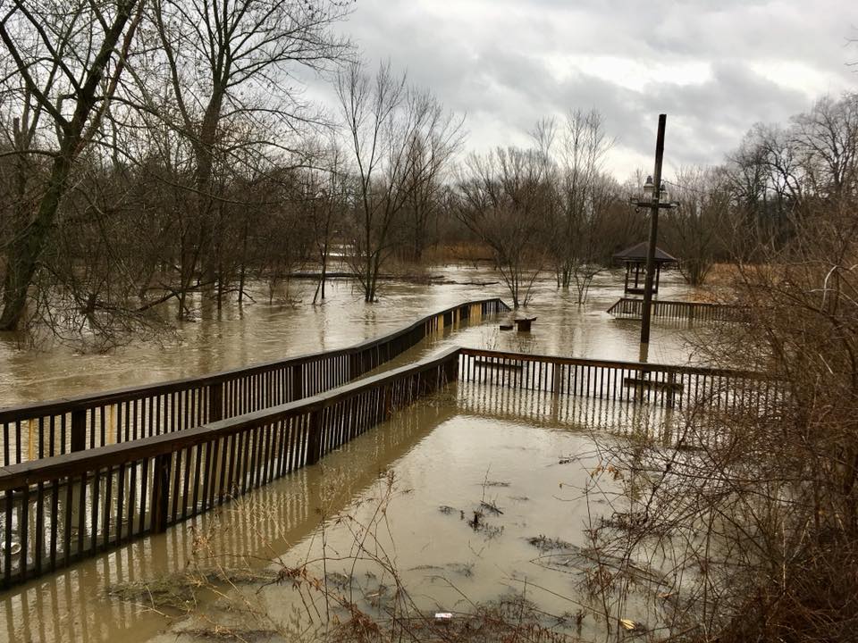
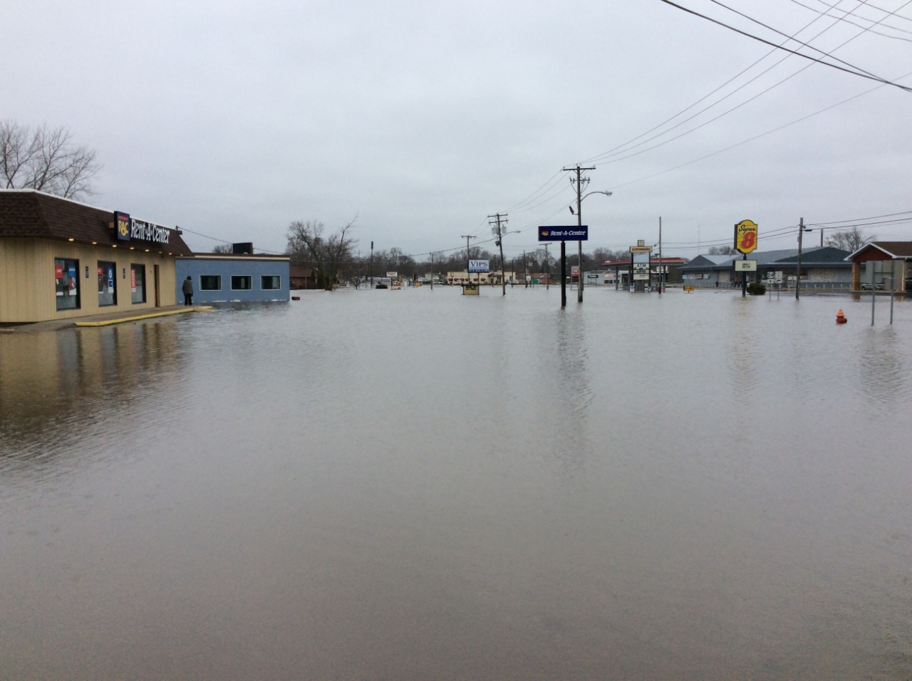
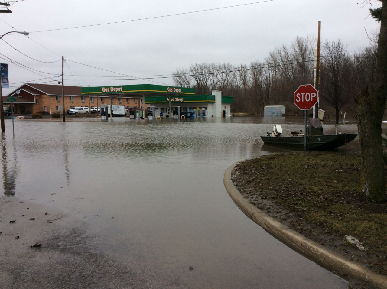
Photos
 |
 |
 |
| Kankakee River in Kankakee County, courtesy of Kankakee County Sheriffs Dept | Kankakee River in Kankakee County, courtesy of Kankakee County Sheriffs Dept | Cissna Park area courtesy of Jessie Campbell |
 |
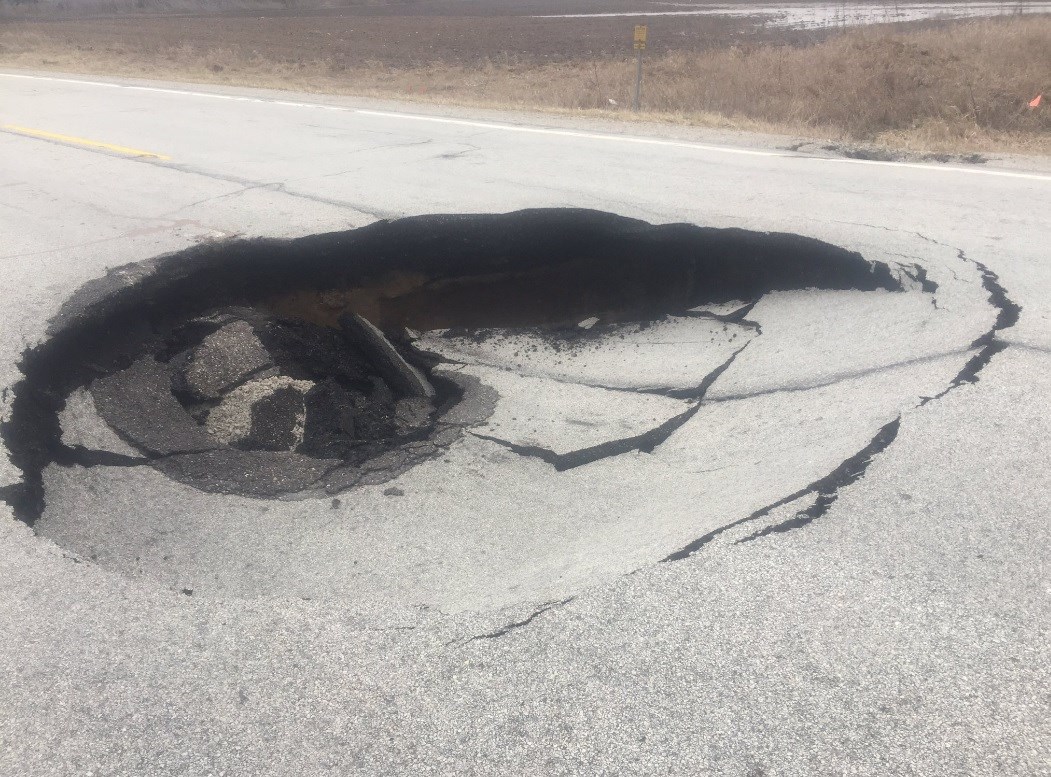 |
| Chesterton, IN courtesy of Bryan Lalevee | Pothole in northwest Indiana courtesy of INDOT. |
Rivers
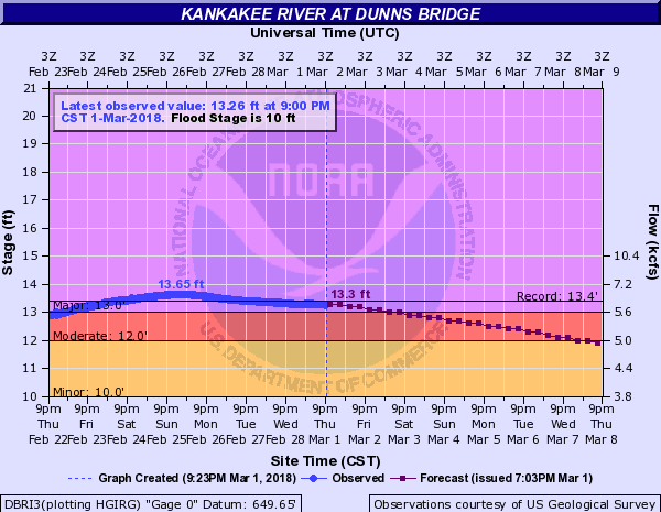
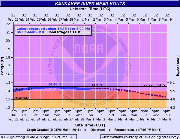
| Observed Stages on the Kankakee River | ||
 |
 |
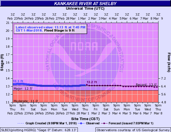 |
| Dunns Bridge hydrograph | Kouts hydrograph | Shelby hydrograph |
| Observed Stages on the Iroquois River | |
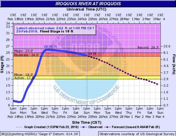 |
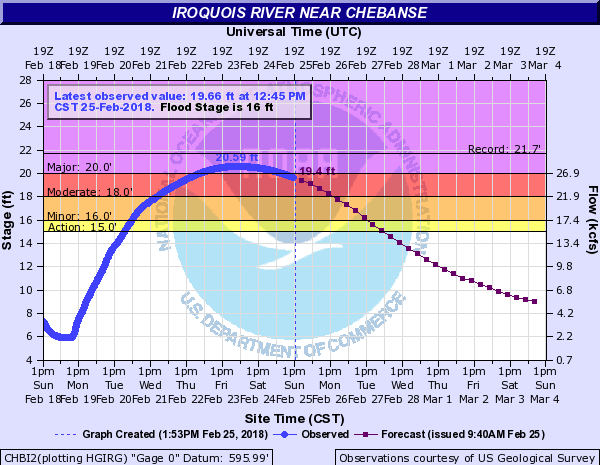 |
| Iroquois hydrograph | Chebanse hydrograph |
| Observed Stages on the Sugar Creek |
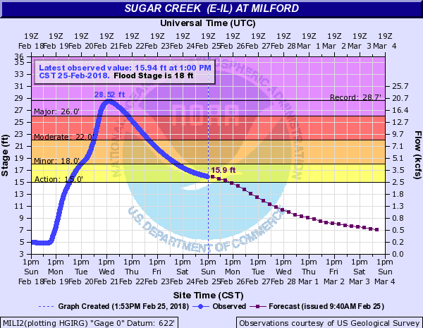 |
| Milford hydrograph |
Meteorology
 |
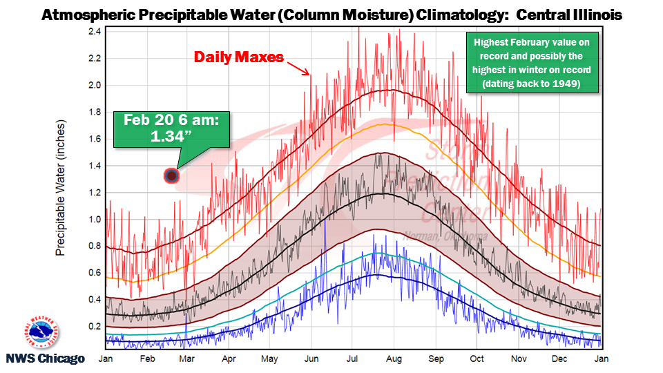 |
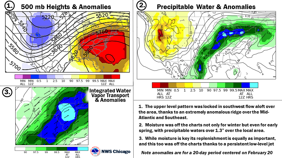
| Anomalies are a way meteorologists can quantify how far from normal the atmosphere is, or predicted to be, and from that quantify how high of magnitude weather event may unfold. | Precipitable water vs climatology as observed on the NWS Lincoln, IL weather balloon launch at 6 am on Feb. 20. |
Service
 |
 |
 |
 |
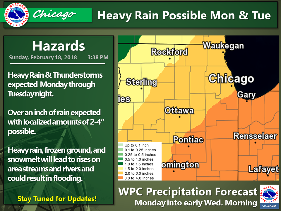
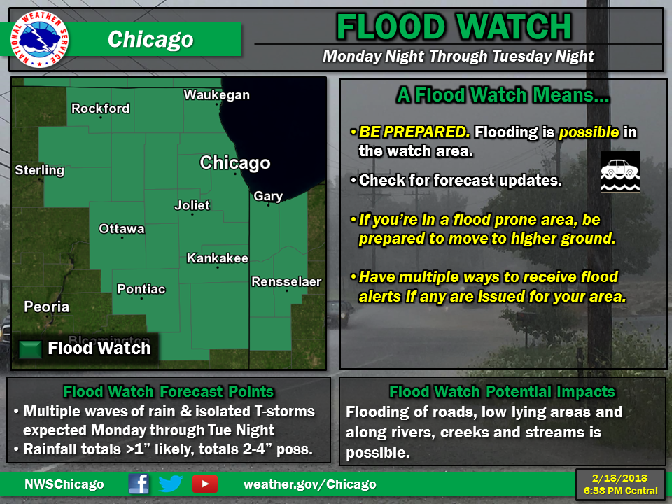
| Feb 18 Weather Story | Feb 18 Flood Watch Issued | Feb 19 Weather Story | Feb 19 Flood Warning |
Survey
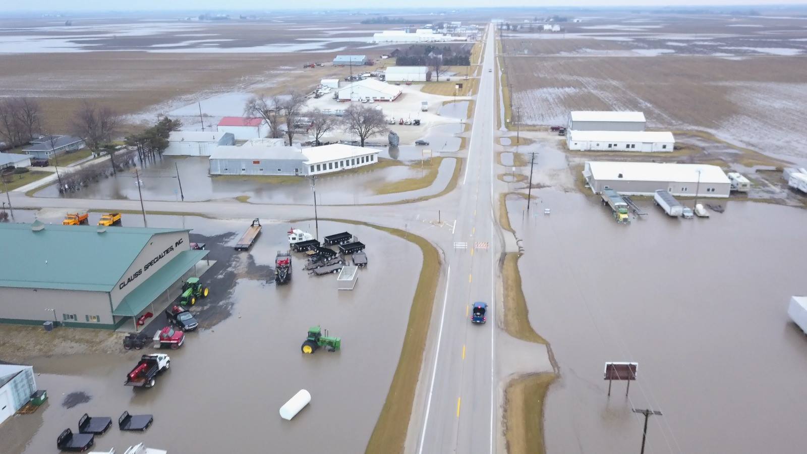
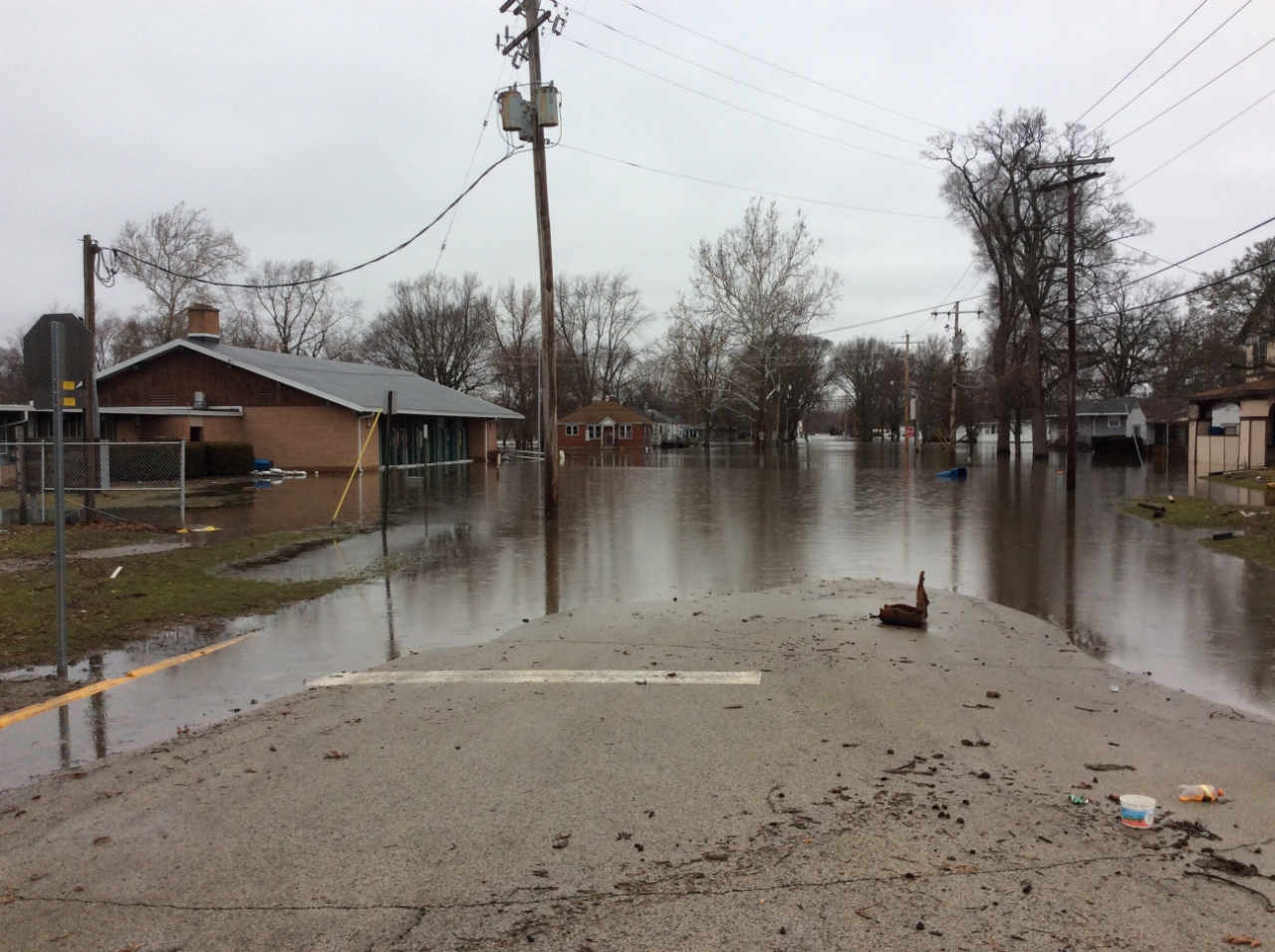
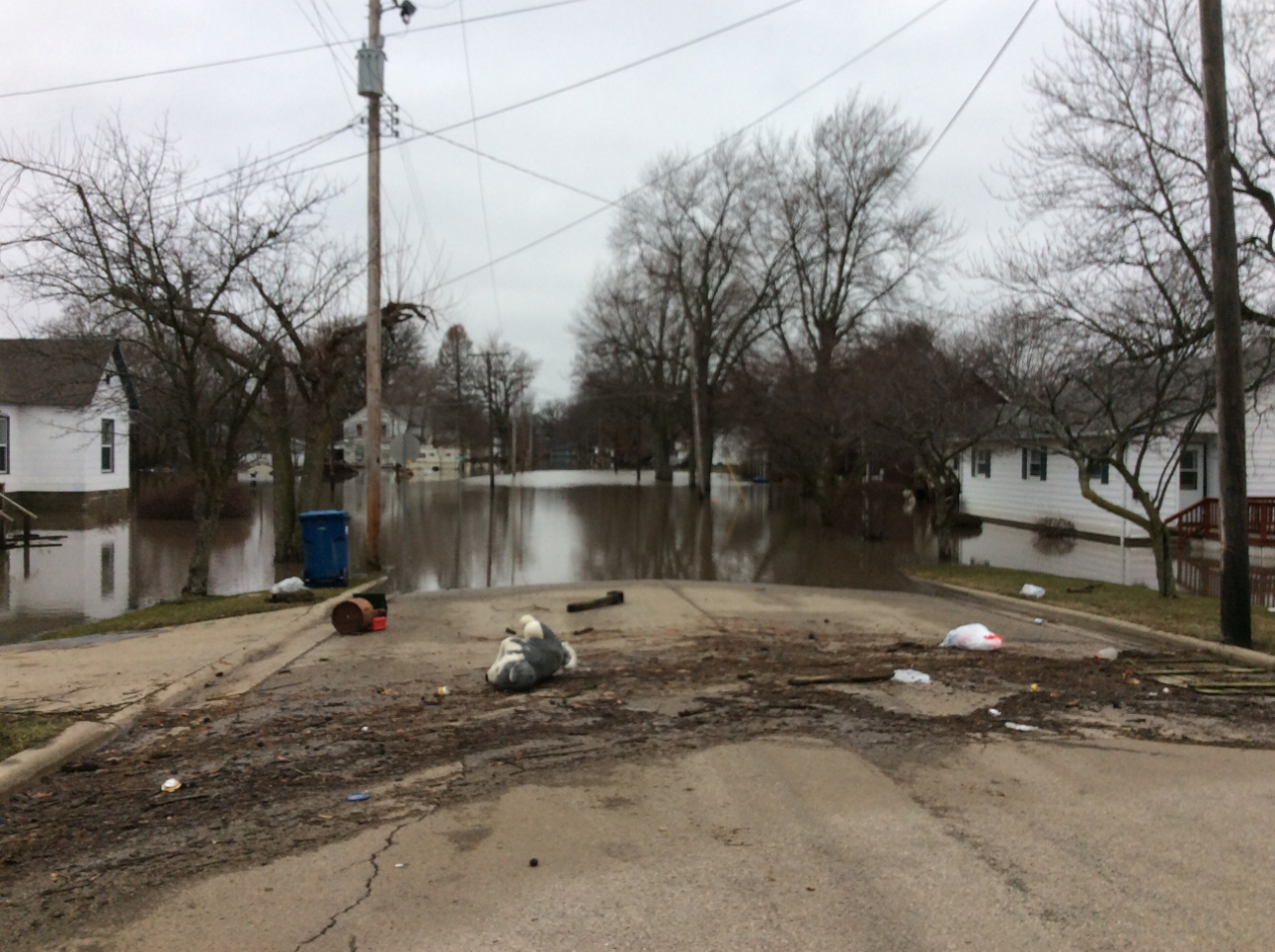
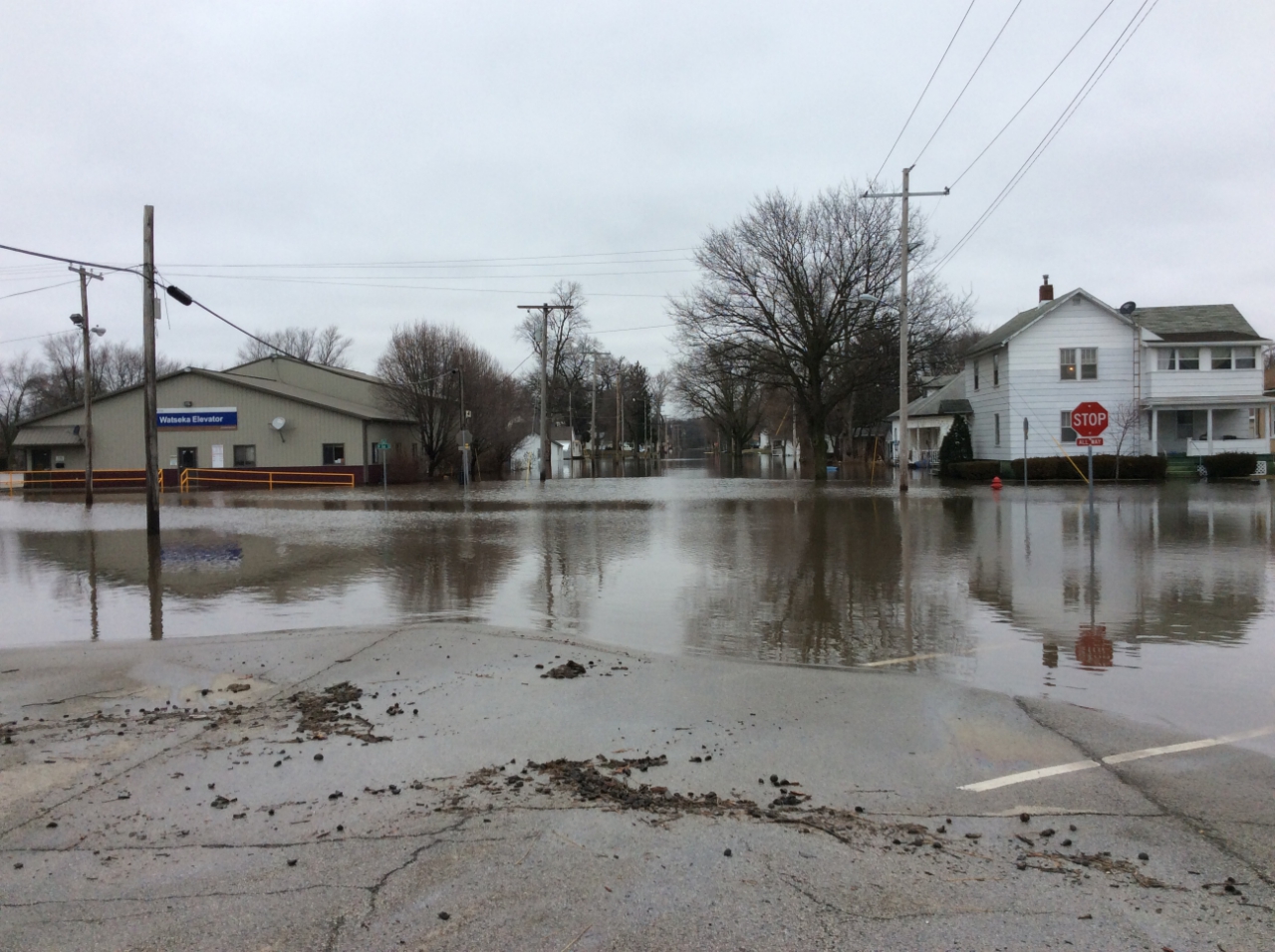
 |
 |
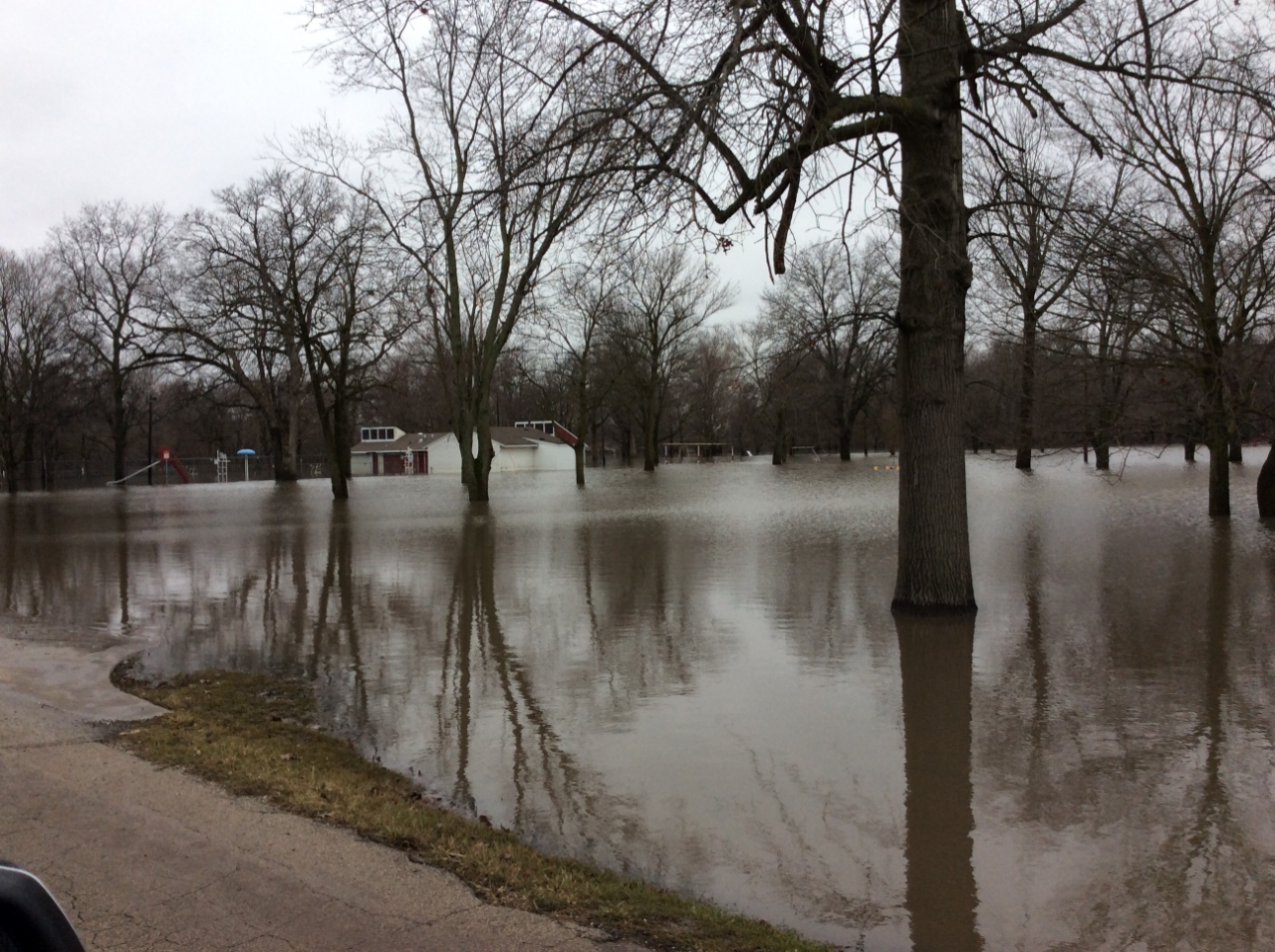 |
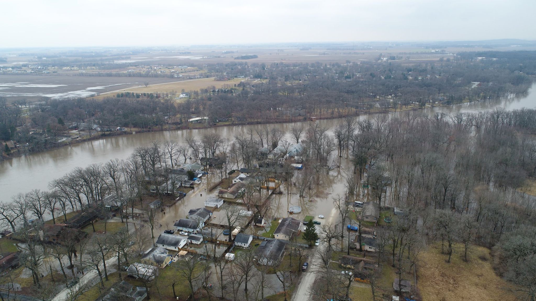
| Rt 24 through downtown Watseka | Rt 24 through downtown Watseka | Legion Park pool house at peak water was up to the roof |
 |
 |
 |
| High water mark at bottom of brick house in Watseka | Sugar Creek in distance at tree line in Watseka | Iroquois River in distance at tree line in Watseka |
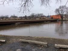
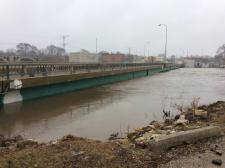 |
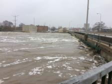 |
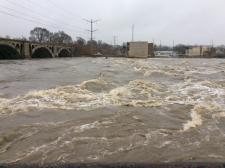 |
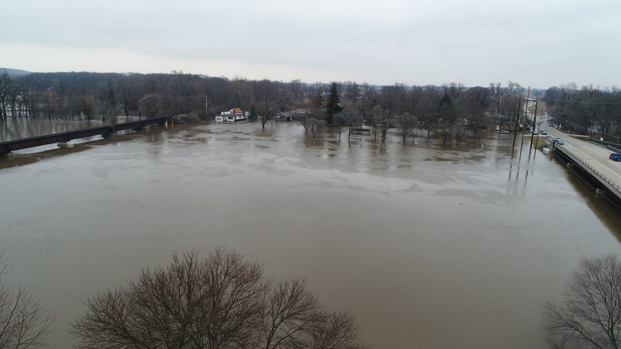
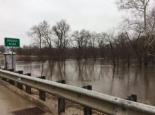
| Washington Ave Bridge downstream in Kankakee | Washington Ave Bridge upstream in Kankakee | Water over-topping the dam on the Kankakee River |
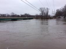 |
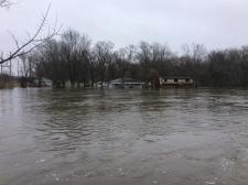 |
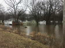 |
| Kankakee River near Rt. 17 bridge | Flooded houses next to Rt 17 bridge on the Kankakee River | Flooded houses next to Rt 17 bridge on the Kankakee River |
 |
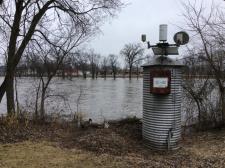 |
 |
| Route 1 bridge in Momence on the Kankakee River | River Gage for the Kankakee River at Momence | River Gage for the Iroquois River at Iroquois |
Additional
 |
Media use of NWS Web News Stories is encouraged! Please acknowledge the NWS as the source of any news information accessed from this site. Additional recaps can be found on the NWS Chicago Past Events Page |
|