Labor Day Weekend is a WET One (Sept 1-4, 2006)
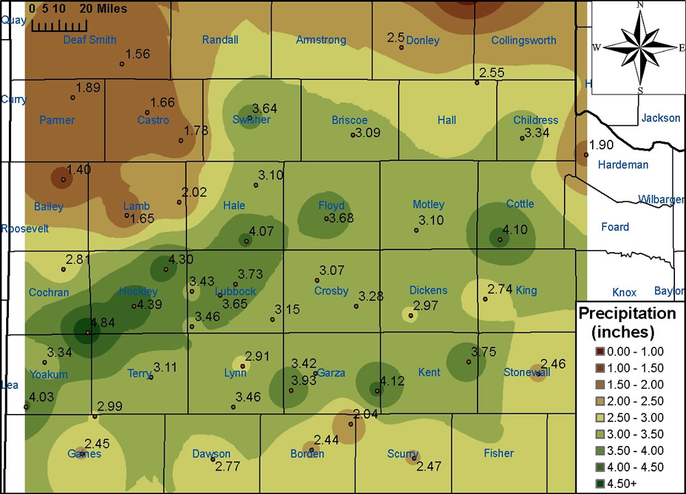
Above is a map of the rainfall (in inches) that fell across the region from Friday, September 1, 2006, through Monday, September 4, 2006. The image was created from data gathered by West Texas Mesonet Stations and official NWS observing sites.
The combination of moisture from once Hurricane John in the eastern Pacific, numerous disturbances passing overhead from the southwest, a stationary front to our south, and a powerful upper-level low and associated strong jet to our north conspired to bring the entire region significant rainfall over the holiday weekend. After showers and storms scattered precipitation across much of the region late Friday into early Saturday, the event turned into more of a soaker by Saturday night, with much of the area experiencing steady rains (occasionally heavy) from late Saturday through Sunday and into the day on Monday. The highest rainfall total recorded by the West Texas Mesonet was 4.84 inches at the station located 8 miles west-southwest of Sundown. A number of other stations received over 4 inches, with numerous sites recording between 2 and 4 inches.
This rainfall has helped the Lubbock airport climb back to within striking distance of normal rainfall for the year. After falling substantially behind average, the 3.73 inches of precipitation over the past few days has brought the yearly total to 11.15 inches, which is only 2.25 inches short of the normal value of 13.40 inches. Additionally, the Childress airport has completed its climb to normal, sitting at 16.74 inches for the year. This is 0.27 inches above the normal of 16.47. Interestingly, all this rain has again pushed Lake Alan Henry over the operational spillway. As of 4 pm Monday, Sept 4, 2006, approximately a half of foot of water was running over the spillway (level was at 2220.54 ft, with spillway level of 2220.0 ft).
Below is a listing of observed rainfall that fell between Friday, September 1, and Monday, September 4, 2006, inclusive. The rainfall totals are in inches.
West Texas Mesonet   	Totals
ABERNATHY 5NE		4.07
AMHERST 1NE		1.65
ANDREWS 2NE		2.92
ANTON 6S		4.30
ASPERMONT 3NE		2.46
BROWNFIELD 2S		3.11
CLARENDON 2W		2.50
DENVER CITY 7W		4.03
DIMMITT 2NE		1.66
FLOYDADA 2NE		3.68
FLUVANNA 3W		2.04
FRIONA 2NE		1.89
GAIL 2SE		2.44
GOODLETT 3W		1.90
GRAHAM 5SW		3.93
GUTHRIE 10W		2.74
HART 3N			1.78
HEREFORD 2NW		1.56
JAYTON 1S		3.75
LAKE ALAN HENRY 1NW	4.12
LAMESA 2SE		2.77
LEVELLAND 4S		4.39
LUBBOCK (TX TECH)	3.65
LUBBOCK (REESE CTR)	3.43
MCLEAN 1E		0.70
MEMPHIS 1NE		2.55
MORTON 1NE		2.81
MULESHOE 2S		1.40
O`DONNELL 1N		3.46
OLTON 6S		2.02
PAMPA 2E		0.72
PADUCAH 10SW		4.10
PLAINS 3N		3.34
PLAINVIEW 1S		3.10
POST 1S			3.42
RALLS 1SE		3.07
ROARING SPRINGS 3N	3.10
SEAGRAVES 1SW		2.99
SEMINOLE 2N		2.45
SILVERTON 7E		3.09
SLATON 2NE		3.15
SNYDER 3E		2.47
SPUR 1W			2.97
SUNDOWN 8SW		4.84
TAHOKA 3NE		2.91
TULIA 2NE		3.64
WHITE RIVER LK 6NW	3.28
WOLFFORTH 6SW		3.46

NWS observing sites  	Totals
LUBBOCK AIRPORT		3.73
CHILDRESS AIRPORT	3.34

