|
Wind, Dust, Rain and Cooler Weather 3-4 September 2011 |
|
|
| Picture of the dust lofted as a strong thunderstorm outflow moved over the Texas Tech Football Stadium on the evening of September 3rd, 2011. Winds gusted to around 40 to 45 mph as the outflow moved through. Click on the image for a larger view. Photo courtesy of Jennifer Daniel. |
| The seemingly never ending heat wave of the summer of 2011 went out with a bang. Saturday, September 3, 2011, brought one last hot day to the South Plains region. Temperatures soared into the 90s, with locations from Childress to Aspermont reaching 100 degrees or higher. This day also marked the 100th straight day that both Lubbock and Childress topped the 90 degree mark. However, unlike the previous 99 days, the extreme heat was not to follow on Sunday. |
|
|
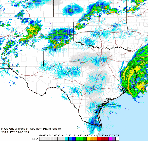
| Radar animation valid from 6:28 pm to 7:38 pm on September 3, 2011. |
| Initially, the heat sparked scattered thunderstorms across the southwest Texas Panhandle Saturday afternoon. This activity generated a strong outflow that pushed southward through the South Plains and sparked new development which further enhanced the outflow. Although rainfall amounts with these storms were generally light and scattered, the strong downburst winds lofted copious amounts of dust and pushed a wall of dust (also known as a haboob) through Lubbock around 7 pm. The above radar animation shows the well-defined gust front as it moved through the central South Plains and produced widespread blowing dust. |
|
|
| Picture of dust as it approached the south side of Lubbock on the evening of September 3rd, 2011. Some locations saw visibilities briefly drop below a mile as the haboob moved through. |
|
Click HERE to view a short movie (in Apple QuickTime format) of the haboob and it moved across Ransom Canyon, courtesy of John Stoudt. The dust quickly thinned behind the gust front Saturday evening (September 3rd). Attention then turned back north as a strong cold front moved in from the Texas Panhandle and interacted with a complex of showers and thunderstorms moving southeast out of eastern New Mexico. The combination of factors brought at least light amounts of rain to much of the South Plains and southern Texas Panhandle, with some locally higher amounts. |
|
|
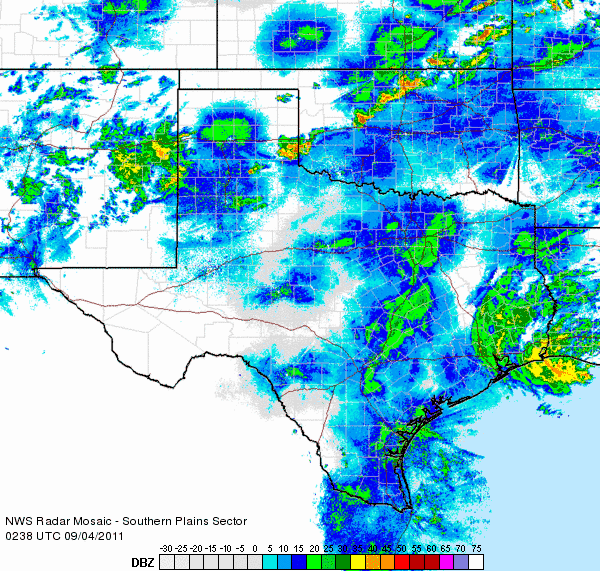
| Radar animation valid from 9:38 pm to 10:48 pm on September 3, 2011. |
| The above radar animation shows the evolution of the rainfall as the cold front moved southward out of the Texas Panhandle late Saturday evening (September 3rd). As the below image shows, many locations across the southern Texas Panhandle into parts of the northern South Plains received the heaviest rainfall. Unfortunately, very little to no rain fell across much of the Rolling Plains as the cold front moved through early Sunday morning. |
|
|
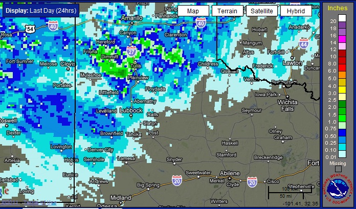
| Bias adjusted radar estimated 24-hour rainfall totals ending at 5 pm on September 4, 2011. |
| The below map shows rain totals, as measured by the West Texas Mesonet stations, between Saturday evening and Sunday evening (September 3rd-4th). Many sites recorded between a tenth and a half an inch, with several places around Hereford, Dimmitt, Hart and Friona seeing upwards of an inch or more. The big winner was the weather observer just outside of Hart who recorded 2.10 inches. The Lubbock Airport officially received 0.48 inches, bringing the yearly total there to 1.97 inches. To view a summary of the rainfall totals from the West Texas Mesonet CLICK HERE. |
|
|
| Twenty-four hour rainfall totals (in inches) ending at 5 pm on September 4, 2011. The data is courtesy of the West Texas Mesonet. Click on the image for a larger view. |
| Even more notable than the rainfall, the strong cold front that moved through late Saturday night and early Sunday morning brought much cooler Canadian air in on gusty northerly winds. In fact, the combination of the cold front and lingering cloud cover through most of Sunday kept temperatures some 25-35 degrees cooler than the day before. The below map shows the observed temperatures at 5 pm on Sunday, September 4th. Note that on most of the previous 100 days (since late May), common temperatures at 5 pm were well into the 90s or in the triple digits. Coupled with breezy northerly winds, this weather sure made for a dramatic, but generally welcome, cool down. |
|
|
| Temperatures observed at 5 pm on September 4, 2011. The data is courtesy of the West Texas Mesonet. Click on the image for a larger view. |


