National Weather Service Lubbock Significant Weather Events
March 12-13, 2019: Severe storms, widespread rain, winds and a tornado
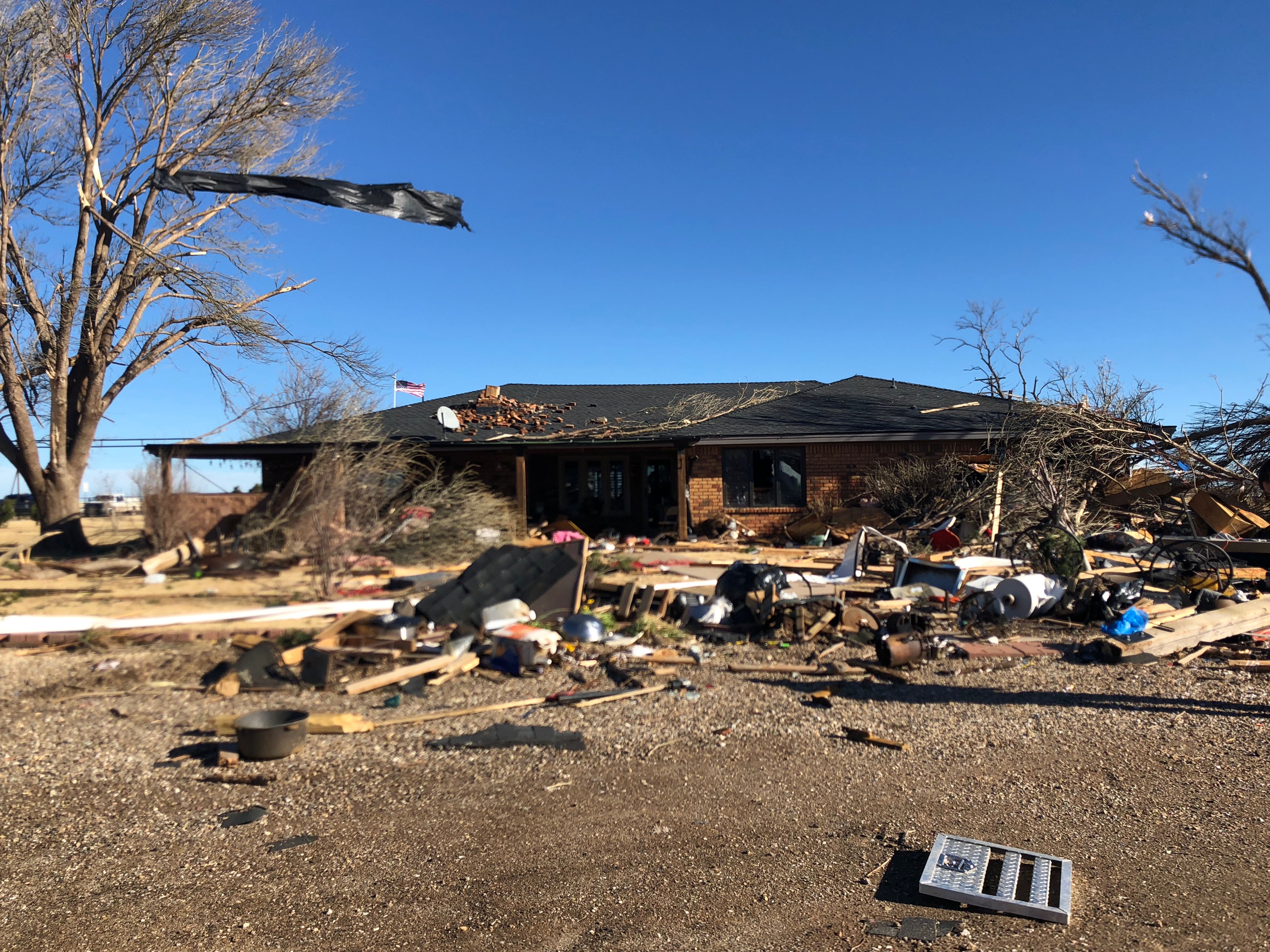
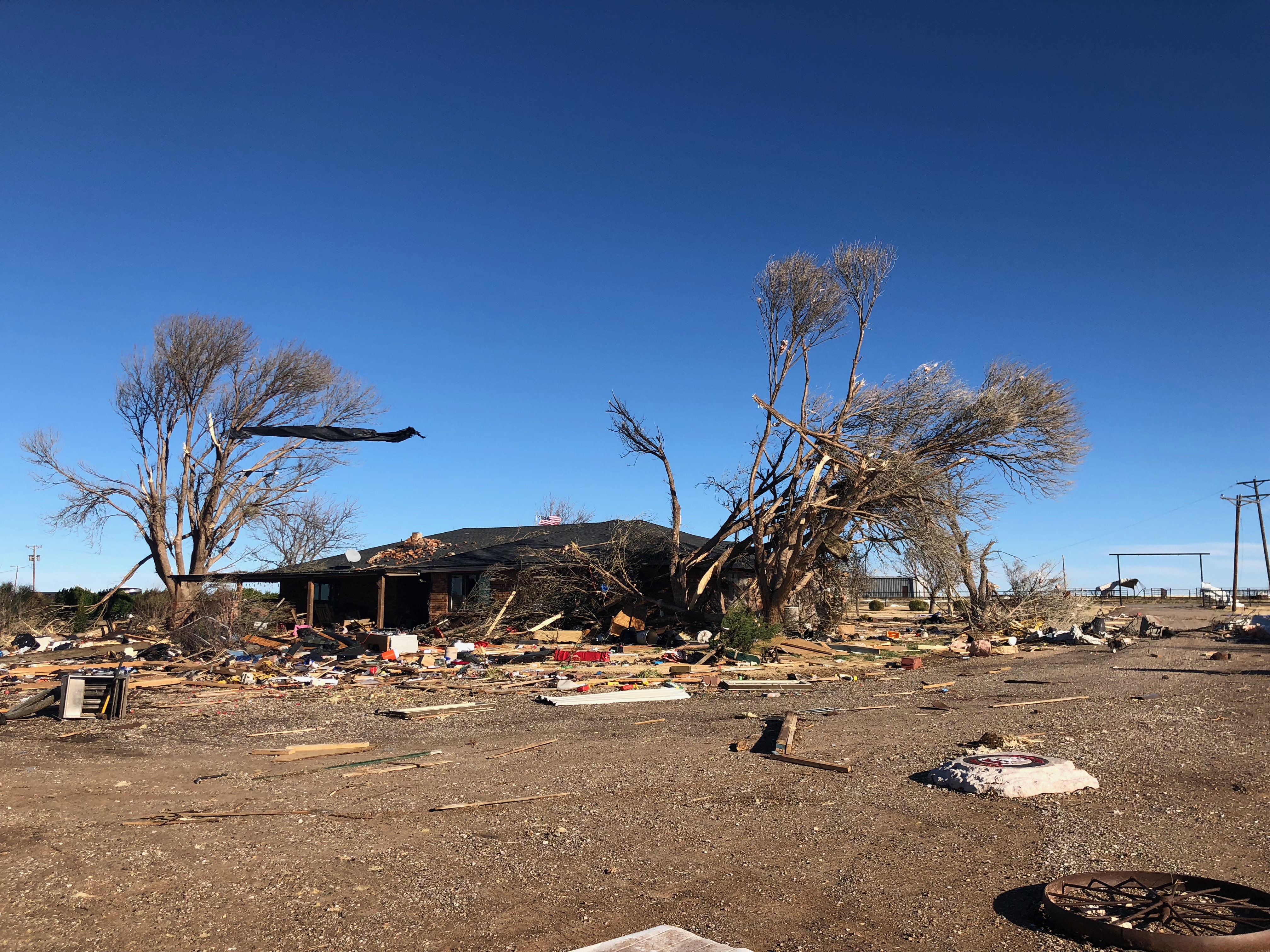
Home damaged by a tornado just east of Anton on Tuesday evening (March 12, 2019). Image was taken the next morning by Marissa Pazos.
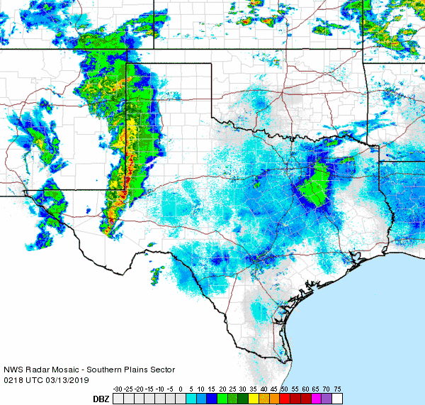
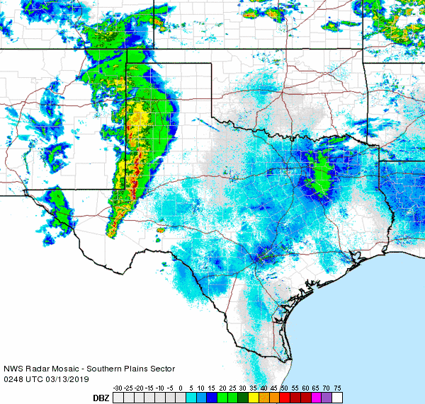
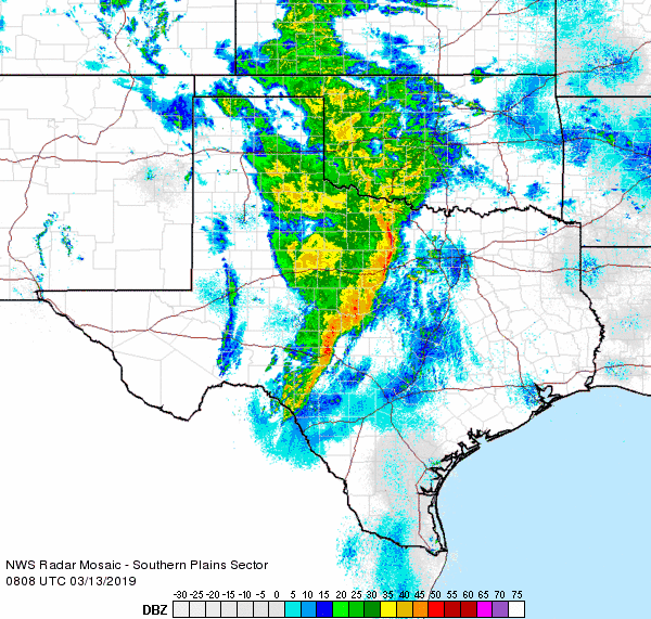
An intense and slow-moving upper level storm system brought a few rounds of showers and thunderstorm Monday into Tuesday (11-12 March 2019). Initially, low-level moisture was lacking and this resulted in only spotty and light rain amounts along with gusty and erratic winds Monday evening. However, as the moisture improved, the showers and thunderstorms became more robust. Eventually, an intense line of thunderstorms that developed across central and eastern New Mexico swept across the South Plains and Rolling Plains late Tuesday evening into the predawn hours of Wednesday (12-13 March). These storms generated gusty winds, and a few of them became severe. In addition, an embedded area of rotation produced a brief tornado as it passed just east of Anton. Unfortunately, the tornado did strike one homestead where it caused a considerable amount of damage.
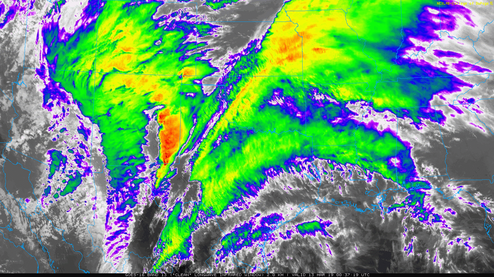
GOES 16 Infrared satellite loop valid from 7:37 pm to 8:37 pm on 12 March 2019. Note the impressive storm system churning across the Desert Southwest, with strong lift in advance of it producing widespread clouds, showers & storms.
The above satellite loop shows the strong storm system as it approached from the Desert Southwest. As the lift with this system emerged over a relatively moist atmosphere across the southern High Plains, thunderstorms erupted. This activity spread rapidly from west-to-east across the South Plains region through the evening and overnight hours (12-13 March).
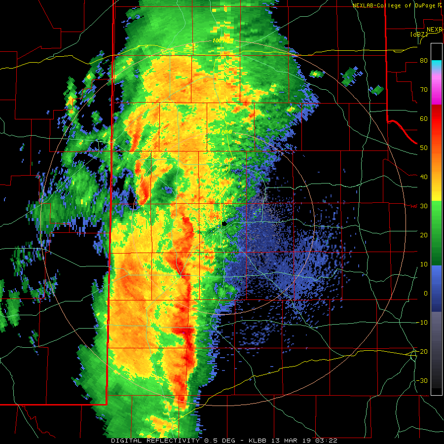
Lubbock radar animation valid from 10:23 pm to 10:57 pm on 12 March 2019.
Widespread moderate to briefly heavy rain accompanied these thunderstorms. In addition, a few of the thunderstorms turned severe. In general, the most intense activity tracked across the central and southern South Plains into the Rolling Plains, where the best instability existed. However, one small circulation embedded in the line of thunderstorms did support the development of a short-lived tornado that tracked north-northeastward about one mile east of Anton.
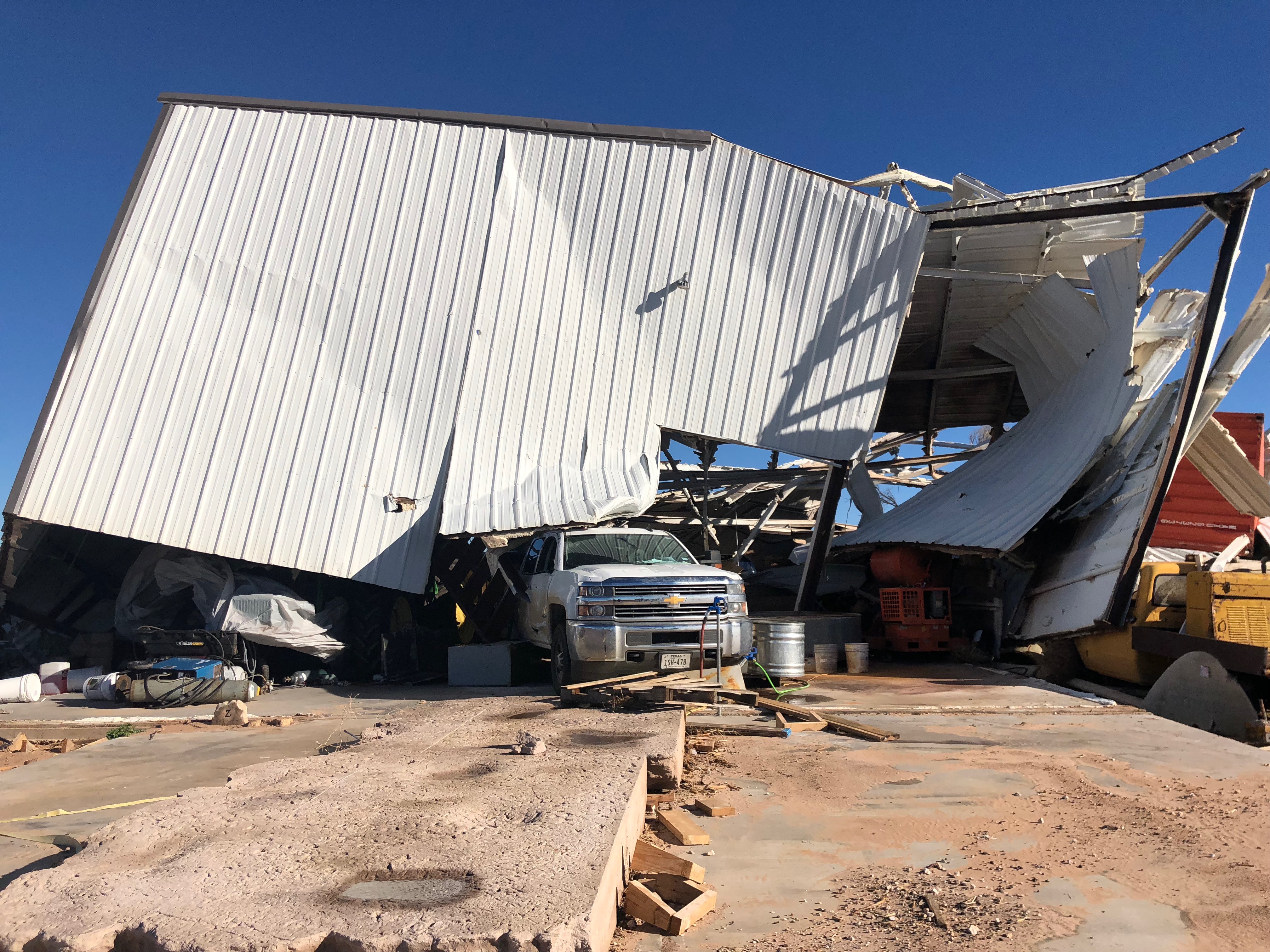
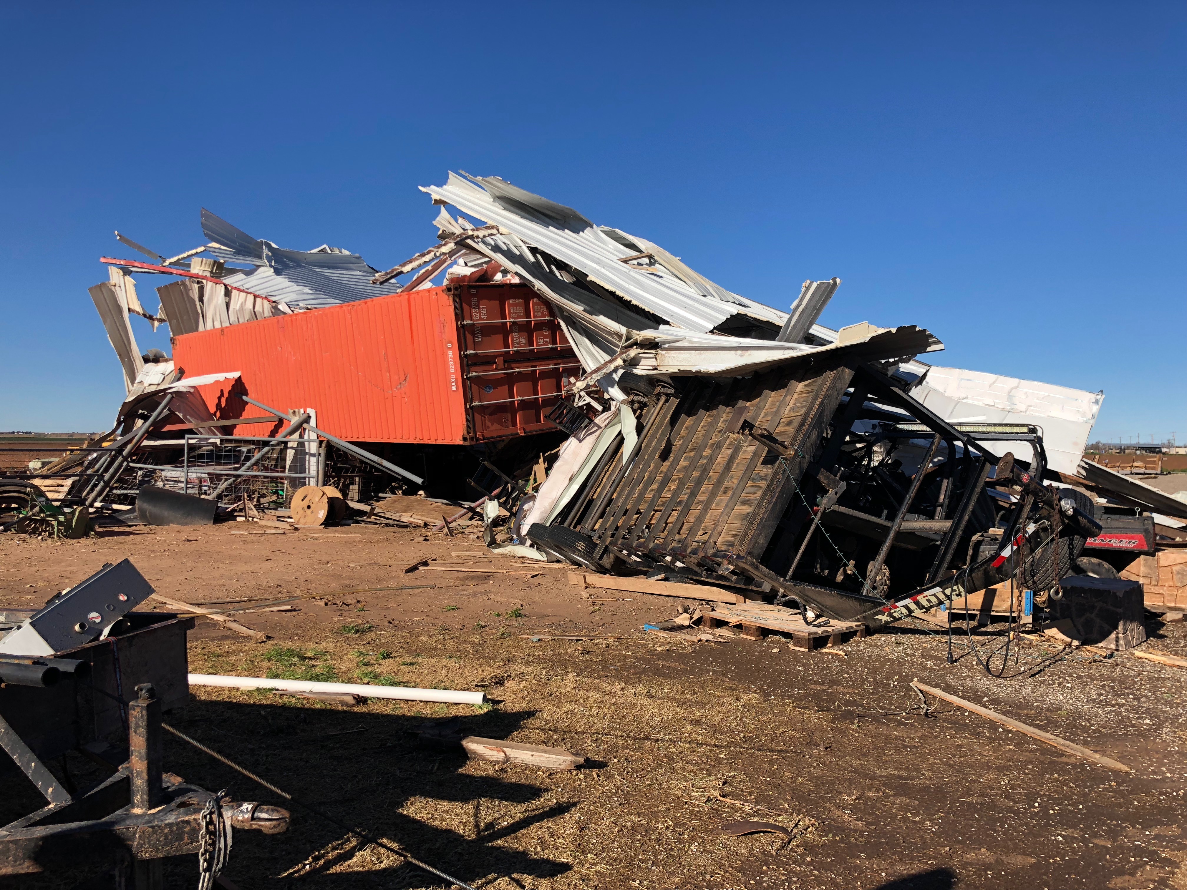
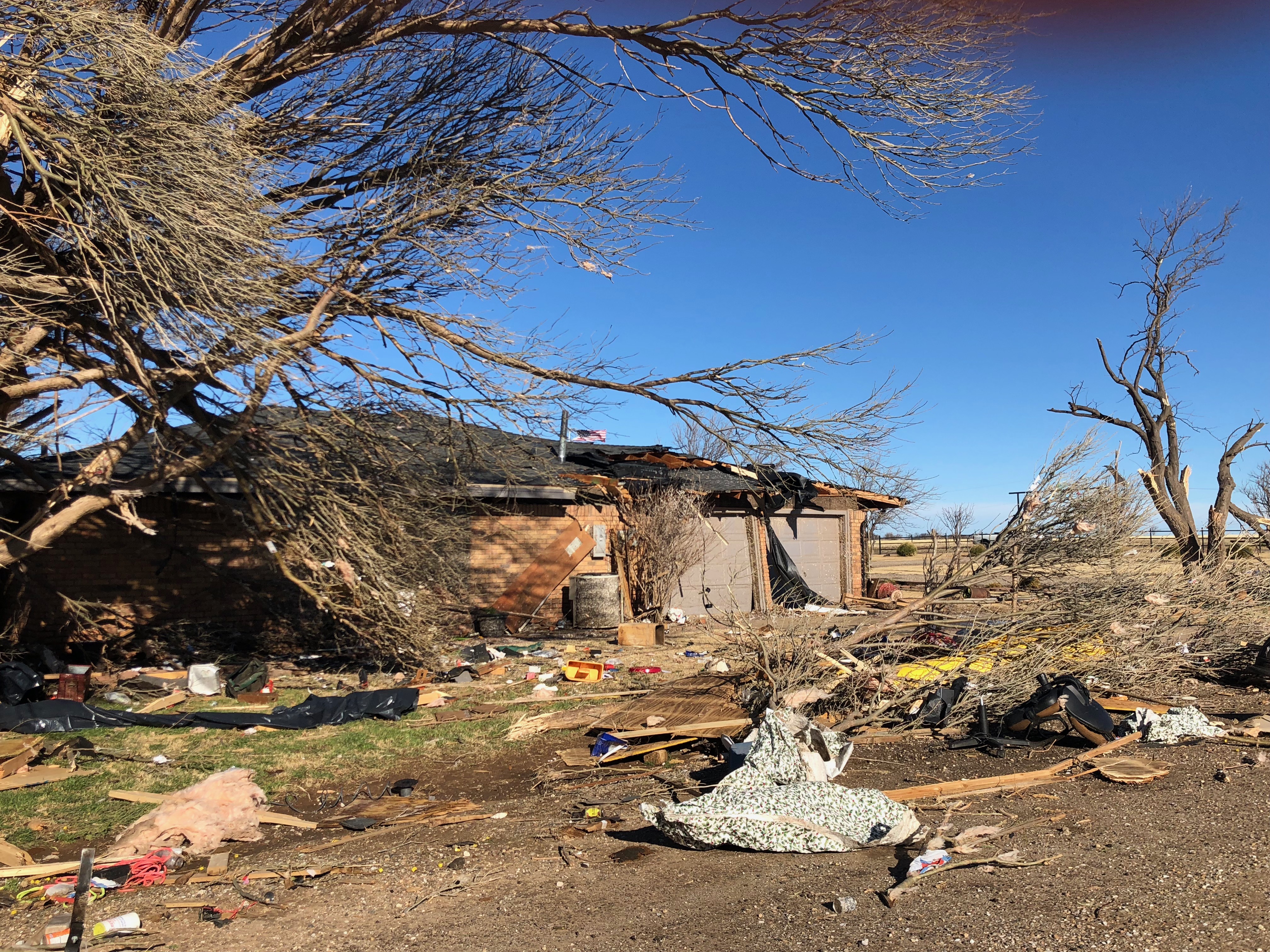
Several views of the tornado damage that occurred to a homestead just east of Anton on the evening of 12 March 2019. The pictures were taken the following morning by Marissa Pazos.
Unfortunately, the tornado did track directly across a single-family residence where it did significant damage. The tornado damaged the house, destroyed a large metal building, snapped tree limbs and power line poles and caused damage to a couple of center pivots. The extent of the damage resulted in a preliminary damage rating of EF-1.
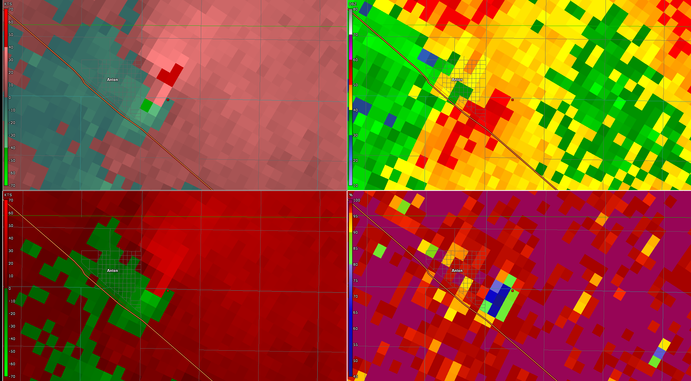
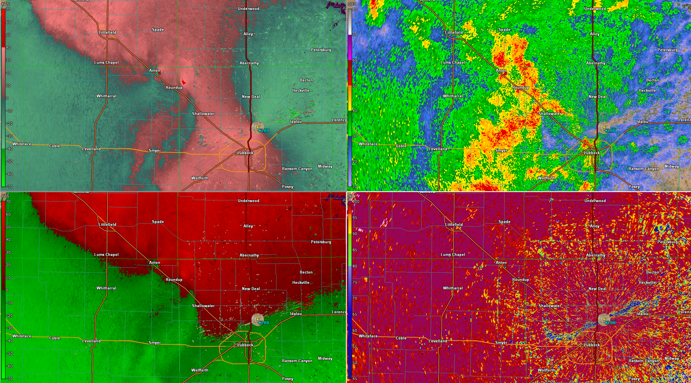
Lubbock base radar imagery captured around the time of the tornado near Anton (10:36 pm on 12 March 2019). UL - Storm relative velocity; UR - Reflectivity; LL - Velocity; and LR - Correlation Coefficient. The red dot is the approximate location where the significant damage to the homestead occurred. A wider view of the same data can be VIEWED HERE.
Radar data captured around the time of the tornado is shown above. The data contain a Tornado Debris Signature (TDS), that is the combination of tight rotational couplet in velocity data, relatively high reflectivity values and a distinct minimum in correlation coefficient. The TDS is the result of radar sampling debris lofted into the air by a tornado.
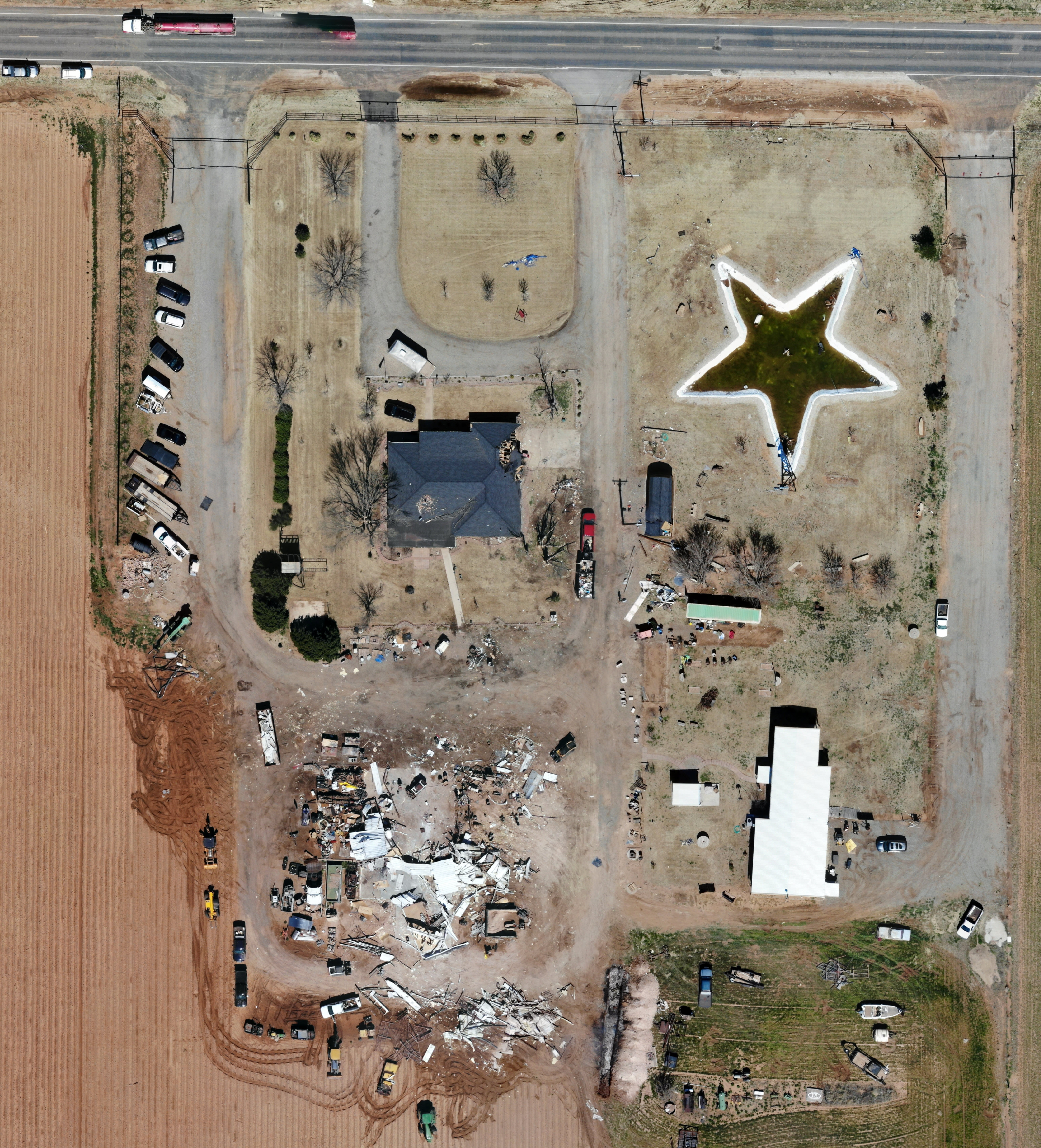
Aerial picture of the homestead that was damaged by the tornado east of the Anton on 12 March 2019. The imagery was captured on 14 March by Caprock Aerial and Survey. A long south-southwest to north-northeast view of the damage path, also courtesy of Caprock Aerial and Survey, can be VIEWED HERE.
To view the complete damage survey results go to the NWS Damage Assessment Viewer (DAT). Once on the DAT page select "Lubbock" for your Office ID. Then select a begin date of 03/11/2019 and an end date of 03/15/2019 toward the top right of the page and click "Filter". At this point the relevant damage survey points east of Anton should be visible. You can then zoom in and select the points to view more details and images. A kml file with the information can also be DOWNLOADED HERE.
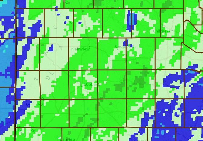
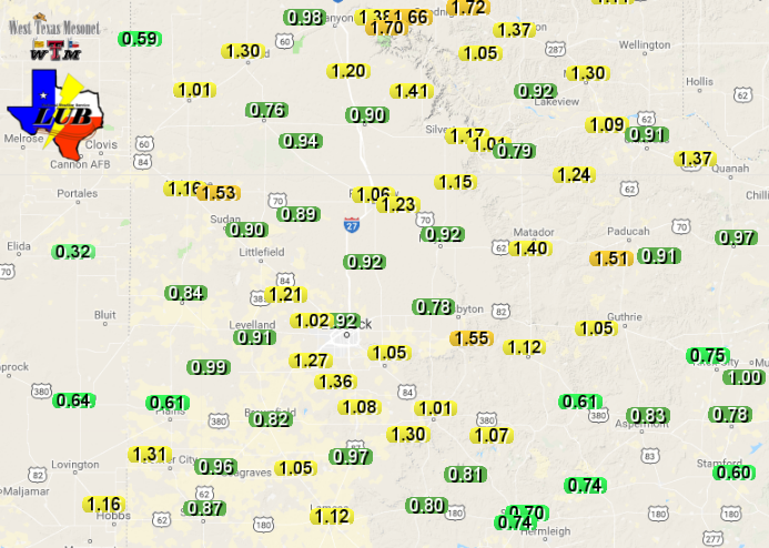
On the positive side, the thunderstorms did bring the first widespread rainfall of 2019 for the region. Rain totals of 0.75" to 1.25" were common for the event. A few localized spots recorded totals near 1.50", including near Spur, Paducah and Earth. Officially, Lubbock recorded 1.09" during the mid-March event. This was the first meaningful precipitation of 2019, boosting the yearly rain total from a paltry 0.07" to a more respectable 1.16". During this same event, Childress recorded 0.97", lifting their yearly total to 1.23".
48-hour radar-estimated and bias-corrected rainfall totals ending at 8 am on 13 March 2019. The first shade of green represents 3/4"+, with the second shade of green representing 1"+. A regional view can be ACCESSED HERE. The rain totals measured by the West Texas Mesonet sites can also be SEEN HERE.
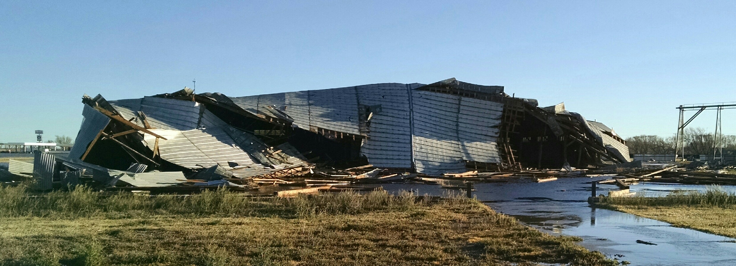
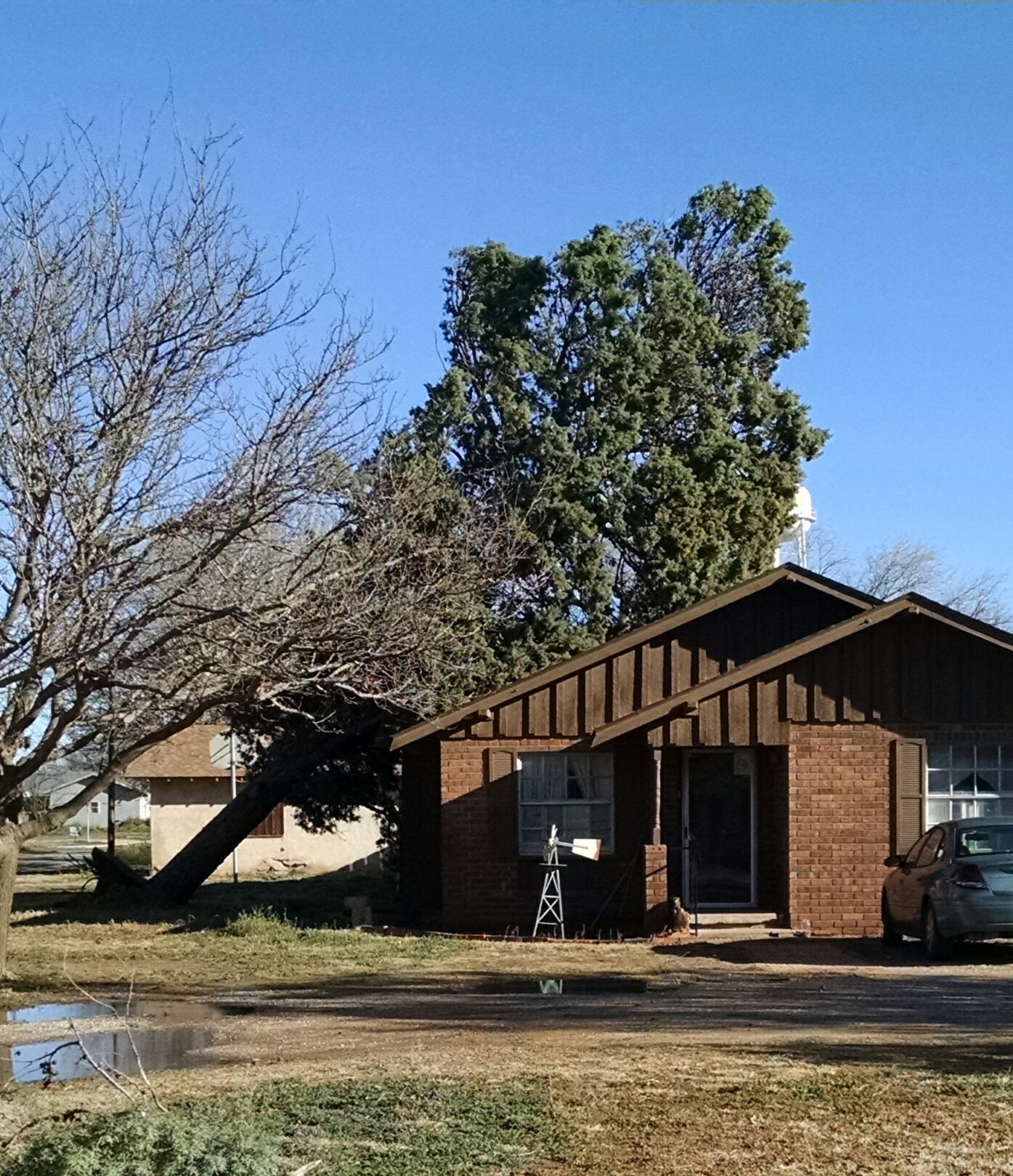
O'Donnell did also experience very strong straight-line winds with the advancing squall line, measured to 72 mph by the nearby West Texas Mesonet. The wind damaged a couple of large buildings, flipped a semi and knocked over trees and power lines around O'Donnell. Pictures of damage that occurred in O'Donnell are displayed below.
Several views of the straight-line wind damage that occurred in O'Donnell on the evening of 12 March 2019.
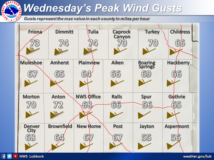
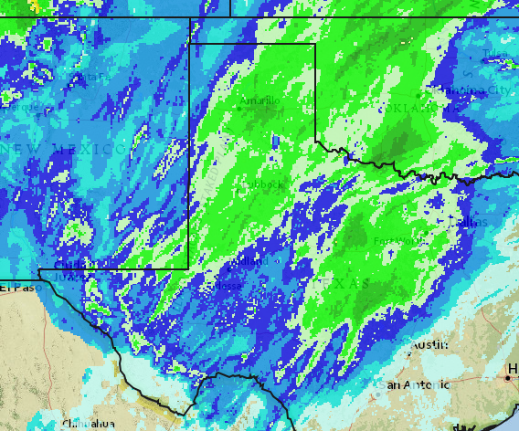
Those that escaped the winds on Tuesday didn't the following day. As the storm system pulled away to our north it intensified rapidly. This resulted in widespread southwesterly winds that gusted from 60 to 70+ mph for a prolonged period of time. The severe winds did cause additional damage and also lofted a lot of blowing dust. Officially, Lubbock measured a peak gust of 67 mph, while the visibility fell to as low as 1 mile during the afternoon because of the thick blowing dust.
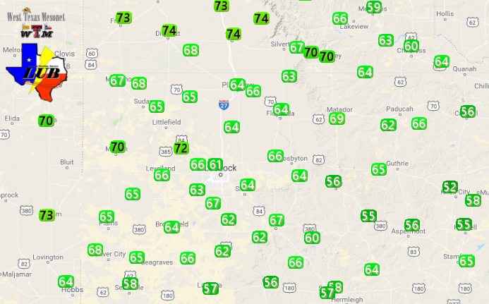
Maximum wind gusts recorded across the South Plains region on Wednesday, 13 March 2019. The data are courtesy of the West Texas Mesonet (WTM) and the National Weather Service. A plot WTM Maximum Wind Gusts and Maximum Sustained Wind Speeds for the 13th are also available by clicking on the relevant links.
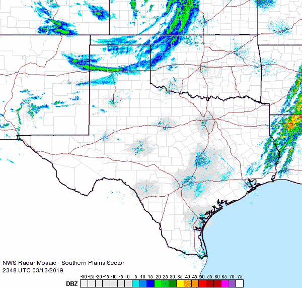
The below radar animation shows a strong cold front moving southward through the Texas Panhandle Wednesday evening. Ahead of the front plumes of dust and smoke can also be seen.
Regional radar animation valid from 6:48 pm to 7:58 pm on 13 March 2019.
A list of the preliminary storm reports and the tornado damage survey for March 12th can be viewed below. Also included are the severe wind gusts and resultant damage reports for the ridiculously windy Wednesday (13 March).
Anton Tornado Damage Survey
PUBLIC INFORMATION STATEMENT...UPDATED
NATIONAL WEATHER SERVICE LUBBOCK TX
201 PM CDT Wed Mar 20 2019

...Updated NWS Damage Survey for the Anton Tornado on March 12...

Updates reflect changes to the tornado`s path length, width,
duration, and damage given further assessment of all available data.

.Anton Tornado...

Rating: EF-1
Estimated Peak Wind: 110 MPH

Path length: 3.4 Miles
Path width: 125 Yards
Fatalities: 0
Injuries: 0

Start Date: March 12, 2019
Start Time: 1035 PM CDT
Start County: Hockley
Start Location: 0.93 miles SE of Anton, TX
Start Lat/Lon: 33.800624 / -102.154940

End Date: March 12, 2019
End Time: 1040 PM CDT
End County: Lamb
End Location: 5.5 miles SSE of Spade, TX
End Lat/Lon: 33.847404 / -102.135941

A rain-wrapped tornado moved north-northeast at approximately
45 mph from extreme northeast Hockley County before ending in far
southeast Lamb County. This tornado inflicted significant damage
to a single family residence just southeast of Anton, completely
destroyed an adjacent large metal building, snapped large tree
limbs, damaged at least six utility poles, and damaged two large
center pivots. After evaluating additional data, the length of
this tornado was increased to 3.4 miles, while the tornado width
was reduced from 200 yards to 125 yards. The Lubbock radar
indicated a TDS to just over 5000 feet at times from structural
debris.

EF Scale:  The Enhanced Fujita Scale Classifies Tornadoes into
the following categories.

EF0...Weak......65 to 85 MPH
EF1...Weak......86 to 110 MPH
EF2...Strong....111 to 135 MPH
EF3...Strong....136 to 165 MPH
EF4...Violent...166 To 200 MPH
EF5...Violent...>200 MPH

Note:
The information in this statement is preliminary and subject to
change pending final review of the event and publication in NWS
Storm Data.
Local Storm Report 3/12/2019
PRELIMINARY LOCAL STORM REPORT
NATIONAL WEATHER SERVICE LUBBOCK TX
436 AM CDT WED MAR 13 2019

..TIME...   ...EVENT...      ...CITY LOCATION...     ...LAT.LON...
..DATE...   ....MAG....      ..COUNTY LOCATION..ST.. ...SOURCE....
            ..REMARKS..

1045 PM     TORNADO          ANTON                   33.81N 102.16W
03/12/2019                   HOCKLEY            TX   EMERGENCY MNGR

            POSSIBLE TORNADO, DAMAGE TO HOUSE AND DEBRIS IN
            POWERLINES.

1055 PM     TSTM WND DMG     O`DONNELL               32.97N 101.83W
03/12/2019                   LYNN               TX   LAW ENFORCEMENT

            *** 1 INJ *** TWO WAREHOUSES HEAVILY DAMAGED, UTILITY
            POLES DAMAGED, AND SEMI BLOWN OVER ON HIGHWAY 87 CAUSING
            MINOR INJURY TO DRIVER.

1055 PM     TSTM WND GST     1 N O`DONNELL           32.98N 101.83W
03/12/2019  M72 MPH          LYNN               TX   MESONET

1115 PM     TSTM WND GST     5 SSW GRAHAM            33.08N 101.52W
03/12/2019  M58 MPH          GARZA              TX   MESONET

1245 AM     TSTM WND GST     10 WSW GUTHRIE          33.57N 100.48W
03/13/2019  M60 MPH          KING               TX   MESONET

            WEST TEXAS MESONET
Local Storm Report 3/13/2019
PRELIMINARY LOCAL STORM REPORT...SUMMARY RETRANSMITTED
NATIONAL WEATHER SERVICE LUBBOCK TX
951 PM CDT WED MAR 13 2019

..TIME...   ...EVENT...      ...CITY LOCATION...     ...LAT.LON...
..DATE...   ....MAG....      ..COUNTY LOCATION..ST.. ...SOURCE....
            ..REMARKS..

1245 AM     TSTM WND GST     10 WSW GUTHRIE          33.57N 100.48W
03/13/2019  M60 MPH          KING               TX   MESONET

            WEST TEXAS MESONET

1000 AM     NON-TSTM WND DMG 1 S JAYTON              33.24N 100.57W
03/13/2019                   KENT               TX   LAW ENFORCEMENT

            TRUCK-TRACTOR SEMI OVERTURNED BY WINDS. MULTIPLE
            UNRELATED POWER OUTAGES.

1148 AM     NON-TSTM WND DMG LUBBOCK                 33.58N 101.88W
03/13/2019                   LUBBOCK            TX   EMERGENCY MNGR

            MULTIPLE DOWNED UTILITY POLES ACROSS THE CITY.

1215 PM     NON-TSTM WND GST 1 S PLAINVIEW           34.16N 101.72W
03/13/2019  M62 MPH          HALE               TX   AWOS

1240 PM     NON-TSTM WND GST 6 SSW ANTON             33.73N 102.19W
03/13/2019  M72 MPH          HOCKLEY            TX   MESONET

            WEST TEXAS MESONET

0102 PM     NON-TSTM WND GST CAPROCK CANYON SP       34.41N 101.06W
03/13/2019  M70 MPH          BRISCOE            TX   MESONET

            WEST TEXAS MESONET

0122 PM     NON-TSTM WND DMG DICKENS                 33.62N 100.84W
03/13/2019                   DICKENS            TX   LAW ENFORCEMENT

            1 ABANDONED BUILDING WITH 2 COLLAPSED WALLS AND ANOTHER
            ABANDONED BUILDING WITH THE ROOF PEELING OFF.

0125 PM     NON-TSTM WND GST 3 N PLAINS              33.23N 102.84W
03/13/2019  M65 MPH          YOAKUM             TX   MESONET

            WEST TEXAS MESONET

0140 PM     NON-TSTM WND GST 2 NNE CHILDRESS         34.46N 100.20W
03/13/2019  M60 MPH          CHILDRESS          TX   MESONET

            WEST TEXAS MESONET

0145 PM     NON-TSTM WND GST 2 NE FRIONA             34.65N 102.69W
03/13/2019  M73 MPH          PARMER             TX   MESONET

            WEST TEXAS MESONET

0150 PM     NON-TSTM WND GST 10 WSW GUTHRIE          33.57N 100.48W
03/13/2019  M65 MPH          KING               TX   MESONET

            WEST TEXAS MESONET

0158 PM     NON-TSTM WND GST 4 SSW LUBBOCK           33.53N 101.88W
03/13/2019  M68 MPH          LUBBOCK            TX   NWS OFFICE

0210 PM     NON-TSTM WND GST 2 WSW TURKEY            34.38N 100.93W
03/13/2019  M70 MPH          HALL               TX   MESONET

            WEST TEXAS MESONET

0210 PM     NON-TSTM WND GST 2 WSW TURKEY            34.38N 100.93W
03/13/2019  M70 MPH          HALL               TX   MESONET

0210 PM     NON-TSTM WND GST 5 SSW GRAHAM            33.08N 101.50W
03/13/2019  M62 MPH          GARZA              TX   MESONET

0215 PM     NON-TSTM WND GST 3 N ROARING SPRINGS     33.94N 100.85W
03/13/2019  M69 MPH          MOTLEY             TX   MESONET

            WEST TEXAS MESONET

0215 PM     NON-TSTM WND GST 4 S LEVELLAND           33.53N 102.36W
03/13/2019  M66 MPH          HOCKLEY            TX   MESONET

            WEST TEXAS MESONET

0215 PM     NON-TSTM WND GST 5 ENE ABERNATHY         33.88N 101.76W
03/13/2019  M64 MPH          HALE               TX   MESONET

            WEST TEXAS MESONET

0221 PM     NON-TSTM WND GST 3 SSE ESTELLINE         34.50N 100.42W
03/13/2019  M63 MPH          HALL               TX   MESONET

            WEST TEXAS MESONET

0230 PM     NON-TSTM WND DMG 13 NW CHILDRESS         34.56N 100.41W
03/13/2019                   CHILDRESS          TX   EMERGENCY MNGR

            SEMI-TRUCK BLOWN OVER IN THE NORTH-BOUND LANES OF US
            287 0.5 MILES EAST OF THE HALL COUNTY BORDER.

0230 PM     NON-TSTM WND GST 6 SSW WOLFFORTH         33.42N 102.05W
03/13/2019  M63 MPH          LUBBOCK            TX   MESONET

            WEST TEXAS MESONET

0230 PM     NON-TSTM WND GST 3 WNW LUBBOCK           33.60N 101.90W
03/13/2019  M61 MPH          LUBBOCK            TX   MESONET

            WEST TEXAS MESONET

0230 PM     NON-TSTM WND DMG CHILDRESS               34.42N 100.25W
03/13/2019                   CHILDRESS          TX   EMERGENCY MNGR

            CATTLE TRUCK BLOWN OVER NEAR THE INTERSECTION OF LOOP 9
            AND US 287 NORTHWEST OF CHILDRESS. LOCATION ESTIMATED AS
            INITIAL REPORT INDICATED LOOP 328 AND US 287 WHICH
            DOESNT APPEAR TO EXIST.

0240 PM     NON-TSTM WND GST 1 NW LAKE ALAN HENRY    33.07N 101.06W
03/13/2019  M60 MPH          GARZA              TX   MESONET

0245 PM     NON-TSTM WND GST 1 S NORTHFIELD          34.27N 100.60W
03/13/2019  M64 MPH          MOTLEY             TX   MESONET

            WEST TEXAS MESONET

0250 PM     NON-TSTM WND GST 6 S OLTON               34.09N 102.12W
03/13/2019  M65 MPH          LAMB               TX   MESONET

            WEST TEXAS MESONET

0255 PM     NON-TSTM WND GST 8 WSW SUNDOWN           33.39N 102.61W
03/13/2019  M65 MPH          COCHRAN            TX   MESONET

            WEST TEXAS MESONET

0300 PM     NON-TSTM WND GST 2 NE DIMMITT            34.57N 102.29W
03/13/2019  M74 MPH          CASTRO             TX   MESONET

            WEST TEXAS MESONET

0300 PM     NON-TSTM WND GST 1 ENE MORTON            33.73N 102.74W
03/13/2019  M70 MPH          COCHRAN            TX   MESONET

            WEST TEXAS MESONET

0300 PM     NON-TSTM WND DMG POST                    33.19N 101.38W
03/13/2019                   GARZA              TX   SOCIAL MEDIA

            CONVENIENCE STORE SIGN DESTROYED

0305 PM     NON-TSTM WND GST 2 S BROWNFIELD          33.15N 102.27W
03/13/2019  M64 MPH          TERRY              TX   MESONET

            WEST TEXAS MESONET

0305 PM     NON-TSTM WND GST 1 NE MEMPHIS            34.73N 100.53W
03/13/2019  M59 MPH          HALL               TX   MESONET

0310 PM     NON-TSTM WND GST 1 SE RALLS              33.67N 101.38W
03/13/2019  M66 MPH          CROSBY             TX   MESONET

            WEST TEXAS MESONET

0310 PM     NON-TSTM WND GST 6 NW WHITE RIVER LAKE   33.53N 101.17W
03/13/2019  M64 MPH          CROSBY             TX   MESONET

            WEST TEXAS MESONET

0310 PM     NON-TSTM WND GST 1 NE POST               33.20N 101.37W
03/13/2019  M67 MPH          GARZA              TX   MESONET

            WEST TEXAS MESONET

0310 PM     NON-TSTM WND GST REESE CENTER            33.61N 102.05W
03/13/2019  M66 MPH          LUBBOCK            TX   MESONET

            WEST TEXAS MESONET

0312 PM     NON-TSTM WND GST 2 SSE HACKBERRY         33.90N 100.13W
03/13/2019  M66 MPH          COTTLE             TX   MESONET

            WEST TEXAS MESONET

0317 PM     NON-TSTM WND GST NEW HOME                33.33N 101.91W
03/13/2019  M67 MPH          LYNN               TX   MESONET

            WEST TEXAS MESONET

0325 PM     NON-TSTM WND GST 2 SSW MULESHOE          34.21N 102.74W
03/13/2019  M67 MPH          BAILEY             TX   MESONET

            WEST TEXAS MESONET

0326 PM     NON-TSTM WND GST 2 S LESLEY              34.65N 100.81W
03/13/2019  M66 MPH          HALL               TX   MESONET

            WEST TEXAS MESONET

0329 PM     NON-TSTM WND GST 6 NNE LUBBOCK           33.67N 101.82W
03/13/2019  M67 MPH          LUBBOCK            TX   ASOS

0329 PM     NON-TSTM WND GST 3 NNE TAHOKA            33.21N 101.78W
03/13/2019  M62 MPH          LYNN               TX   MESONET

            WEST TEXAS MESONET

0335 PM     NON-TSTM WND GST 2 NE SLATON             33.46N 101.62W
03/13/2019  M64 MPH          LUBBOCK            TX   MESONET

            WEST TEXAS MESONET

0335 PM     NON-TSTM WND GST 2 NNE FLOYDADA          34.00N 101.33W
03/13/2019  M64 MPH          FLOYD              TX   MESONET

            WEST TEXAS MESONET

0340 PM     NON-TSTM WND GST 1 S PLAINVIEW           34.18N 101.71W
03/13/2019  M64 MPH          HALE               TX   MESONET

            WEST TEXAS MESONET

0340 PM     NON-TSTM WND GST 1 S PLAINVIEW           34.18N 101.72W
03/13/2019  M64 MPH          HALE               TX   MESONET

0350 PM     NON-TSTM WND GST 7 ESE SILVERTON         34.45N 101.19W
03/13/2019  M67 MPH          BRISCOE            TX   MESONET

            WEST TEXAS MESONET

0359 PM     NON-TSTM WND GST 3 ENE SOUTH PLAINS      34.24N 101.26W
03/13/2019  M63 MPH          FLOYD              TX   MESONET

            WEST TEXAS MESONET

0405 PM     NON-TSTM WND GST 3 N HART                34.42N 102.11W
03/13/2019  M68 MPH          CASTRO             TX   MESONET

            WEST TEXAS MESONET

0415 PM     NON-TSTM WND GST 2 ENE TULIA             34.54N 101.74W
03/13/2019  M74 MPH          SWISHER            TX   MESONET

            WEST TEXAS MESONET

0423 PM     NON-TSTM WND GST 3 WSW AIKEN             34.13N 101.57W
03/13/2019  M66 MPH          HALE               TX   MESONET

            WEST TEXAS MESONET

0445 PM     NON-TSTM WND GST VIGO PARK               34.65N 101.50W
03/13/2019  M74 MPH          SWISHER            TX   MESONET

            WEST TEXAS MESONET

0450 PM     NON-TSTM WND GST 1 NE AMHERST            34.02N 102.40W
03/13/2019  M65 MPH          LAMB               TX   MESONET

            WEST TEXAS MESONET

0459 PM     NON-TSTM WND GST 9 WSW EARTH             34.19N 102.56W
03/13/2019  M68 MPH          LAMB               TX   MESONET

            WEST TEXAS MESONET

0500 PM     NON-TSTM WND GST HAPPY                   34.74N 101.84W
03/13/2019  M73 MPH          SWISHER            TX   MESONET

            WEST TEXAS MESONET

0510 PM     NON-TSTM WND GST 1 N O`DONNELL           32.98N 101.83W
03/13/2019  M62 MPH          LYNN               TX   MESONET

            WEST TEXAS MESONET

0833 PM     NON-TSTM WND GST 7 WNW DENVER CITY       33.01N 102.94W
03/13/2019  M68 MPH          YOAKUM             TX   MESONET

0921 PM     NON-TSTM WND GST 10 SW PADUCAH           33.91N 100.43W
03/13/2019  M62 MPH          COTTLE             TX   MESONET


&&

EVENT NUMBER LUB1900121 LUB1900171 LUB1900146 LUB1900158 LUB1900142
LUB1900123 LUB1900167 LUB1900139 LUB1900166 LUB1900126 LUB1900141
LUB1900169 LUB1900130 LUB1900173 LUB1900174 LUB1900147 LUB1900152
LUB1900157 LUB1900168 LUB1900138 LUB1900151 LUB1900156 LUB1900175
LUB1900176 LUB1900162 LUB1900131 LUB1900145 LUB1900133 LUB1900150
LUB1900172 LUB1900163 LUB1900170 LUB1900124 LUB1900143 LUB1900144
LUB1900148 LUB1900137 LUB1900136 LUB1900135 LUB1900154 LUB1900153
LUB1900159 LUB1900140 LUB1900155 LUB1900161 LUB1900179 LUB1900125
LUB1900164 LUB1900149 LUB1900160 LUB1900128 LUB1900134 LUB1900165
LUB1900127 LUB1900129 LUB1900132 LUB1900178 LUB1900177


$$

MCQUEEN


