Overview
On the evening of (Sunday) April 12, low pressure was over the central Mississippi Valley. Its associated warm front was over the Deep South while the trailing cold front extended SW into the western Gulf of America. This low pressure system was responsible for strong/violent tornadoes across Mississippi. Locally, temperatures were in the mid-upper 60s with dew points in the low-mid 50s during the late evening hours of 4/12. Some pre-frontal light to moderate rain was over the area, while a strongly forced line of strong-severe thunderstorms extended from southwest Tennessee to Alabama (well ahead of the cold front). Any sort of pre-frontal instability was well to the south/west of the local area. The area of low pressure intensified as it quickly tracked northeast into the southern Great Lakes by early Monday morning. As this happened, the warm front moved northward into our local area as the line of storms from TN to AL tracked ENE to a position from just west of our CWA (while extending hundreds of miles south to South Carolina/Georgia) by 5-6 AM Monday. The environment at this time was characterized by a strong (60-80 kt) 925 mb jet, temperatures/dew points in the low-mid 60s, and south-southeasterly surface winds. While low-level shear (and resultant storm-relative helicity) values were extremely impressive, no tornadoes were reported as this line crossed the CWA from west to east during the 6-10 AM timeframe (perhaps in part due to the marginal level of instability). However, there were several reports of thunderstorm wind damage over parts of the area from this line.
While the thunderstorms produced some wind damage, the most impressive aspect of this system was the high synoptic/gradient wind gusts observed during the day (mainly from mid morning-early afternoon) after the warm front surged north of the region and winds turned to the south. The aforementioned (60-80 knot-highest near the coast) low level jet remained in place through much of the morning-midday. Frequent gusts of 45-60 mph were observed in many locations during this time, which knocked down several trees and caused numerous power outages (especially on the Lower MD Eastern Shore, Hampton Roads (in SE VA), and NE NC). Between 10 AM and noon, there were a couple of brief periods where gusts of 65-75 mph were observed across Hampton Roads (well after any thunderstorms were ongoing). We are still looking into exactly why this happened, but hypothesize that a series of gravity waves allowed higher winds aloft to briefly mix down to the surface. Lastly, rapid rises in water levels were observed on 4/13 in areas from Edenton to Elizabeth City (adjacent to the northern side of the Albemarle Sound and associated tidal rivers). Elizabeth City saw the worst of the (measured) tidal flooding, where water levels peaked a few tenths of a foot below major flood stage. See the Tidal Flooding/Wind Graphs section for more details on the exact progression of tides at Elizabeth City/Edenton.
Wind Speed Reports:
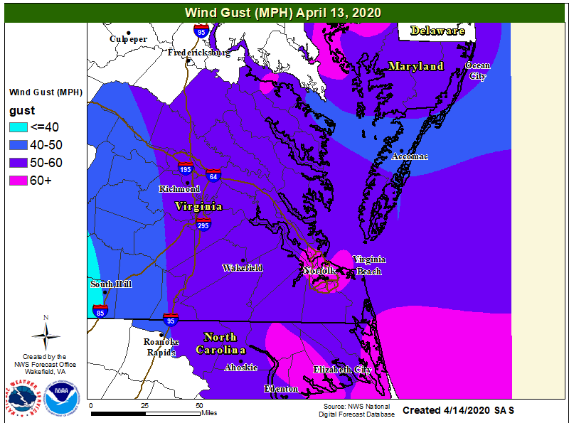
Public Information Statement
National Weather Service Wakefield VA
1149 AM EDT Mon Apr 13 2020

...HIGHEST WIND REPORTS...

Location                     Speed     Time/Date       Lat/Lon

...Maryland...

...Dorchester County...
Cambridge-Dorch              63 MPH    1005 AM 04/13   38.53N/76.03W
Blackwater                   56 MPH    1026 AM 04/13   38.45N/76.09W

...Wicomico County...
Salisbury Wicomico Airport   54 MPH    0935 AM 04/13   38.33N/75.50W

...North Carolina...

...Chowan County...
Edenton                      56 MPH    1055 AM 04/13   36.02N/76.57W

...Currituck County...
3.0 E Knotts Island (WEATHER 64 MPH    1130 AM 04/13   36.52N/75.87W

...Hertford County...
Ahoskie Tri Coun             54 MPH    0935 AM 04/13   36.28N/77.17W

...Northampton County...
Conway                       54 MPH    0950 AM 04/13   36.43N/77.23W

...Pasquotank County...
Elizabeth City Airport       58 MPH    1048 AM 04/13   36.27N/76.18W
Elizabeth City               57 MPH    1113 AM 04/13   36.35N/76.28W

...Perquimans County...
Chapanoke                    66 MPH    1105 AM 04/13   36.24N/76.36W

...Virginia...

...City of Chesapeake County...
Norfolk Hampton              53 MPH    1003 AM 04/13   36.78N/76.45W
Chesapeake                   53 MPH    0955 AM 04/13   36.67N/76.32W

...City of Norfolk County...
Lafayette River              74 MPH    1010 AM 04/13   36.89N/76.32W
Norfolk Intl Airport         68 MPH    1021 AM 04/13   36.90N/76.20W
Norfolk NAS Cham             62 MPH    1016 AM 04/13   36.92N/76.27W
HRBT - South Island          60 MPH    1015 AM 04/13   36.98N/76.30W

...City of Suffolk County...
Suffolk                      58 MPH    0955 AM 04/13   36.68N/76.60W

...City of Virginia Beach County...
Oceana NAS Souce             54 MPH    1003 AM 04/13   36.82N/76.02W

...Northampton County...
Kiptopeke, VA                55 MPH    1048 AM 04/13   37.17N/75.99W

...Maryland...

...Maritime Stations...
Ocean City                   52 MPH    0819 AM 04/13   38.33N/75.08W

...Virginia...
Cape Henry, VA               73 MPH    1018 AM 04/13   36.93N/76.01W
Willoughby Deguassing Statio 67 MPH    1018 AM 04/13   36.98N/76.32W
Rudee Inlet                  65 MPH    1005 AM 04/13   36.83N/75.97W
6 NW Cape Henry              63 MPH    1030 AM 04/13   37.00N/76.09W
Middle Ground Lighthouse     61 MPH    1016 AM 04/13   36.95N/76.39W
Sandbridge                   59 MPH    1053 AM 04/13   36.70N/75.93W
&&
Tidal Flooding Graphs
All Hydrographs are in reference to MLLW
 |
 |
| Water Levels on the Pasquotank River at Elizabeth City | Water Levels on the Chowan River at Edenton |
Wind Graphs (source: WeatherFlow.com)
 |
 |
 |
 |
| Lafayette River (near Portsmouth/Norfolk) | Norfolk Int'l Airport (note the peak gust of 68 MPH is not shown) | First Landing (in the mouth of the Chesapeake Bay) | Willoughby Degaussing Station (in the Lower James River) |
Photos
 |
 |
 |
 |
| Wind Damage in VA Beach (Credit: Spot on Weather-Twitter) |
Tree Uprooted in Dorchester County, Maryland (Credit: Reece Todd-Twitter) |
Power Poles Down in Chesapeake (Credit: J. Huffaker-Twitter) |
Tree Down in Blue Bird Park in Norfolk (Credit: Ana Ley-Twitter) |
Radar/Satellite
Selected Images
 |
 |
| Loop of 0.5° Reflectivity/Velocity from 6-11 AM in ~20 minute increments. SVR Warnings are in red and TOR Warnings are in Purple. Note the high inbound velocities just to the south of the radar during the latter part of the loop. These measured winds of ~80 knots at ~2000 ft AGL show the impressive south-southwesterly low-level jet. | Visible Satellite Loop from ~1030 AM to 2 PM showing transverse bands propagating from SW to NE over SE VA/eastern NC. |
Storm Reports
0645 AM     TSTM WND DMG     OAK FOREST              37.54N 78.20W
04/13/2020                   CUMBERLAND         VA   911 CALL CENTER

            TREES DOWN. VERY HIGH WIND LIKELY 60 MPH OR
            GREATER REPORTED BY 911 CENTER.
0711 AM     TSTM WND DMG     1 NNE FREDERICKS HALL   37.99N 77.82W
04/13/2020                   LOUISA             VA   911 CALL CENTER

            TREES DOWN ON ELK CREEK RD.
0657 AM     TSTM WND DMG     1 SW LOUISA             38.01N 78.01W
04/13/2020                   LOUISA             VA   911 CALL CENTER

            TREES DOWN ON COURTHOUSE RD WEST OF LOUISA.
0724 AM     TSTM WND DMG     2 NNW BEAVERDAM         37.97N 77.66W
04/13/2020                   HANOVER            VA   911 CALL CENTER

            TREES DOWN IN NORTHWEST HANOVER COUNTY NEAR
            BEAVERDAM.
0708 AM     TSTM WND DMG     4 SSW DEATONVILLE       37.28N 78.21W
04/13/2020                   NOTTOWAY           VA   911 CALL CENTER

            TREE DOWN BLOCKING HOLLY FARMS RD.
0645 AM     TSTM WND DMG     2 WSW FARMVILLE         37.29N 78.43W
04/13/2020                   PRINCE EDWARD      VA   DEPT OF HIGHWAYS

            TREE DOWN BLOCKING BACK HAMPDEN SYDNEY RD.
0745 AM     TSTM WND DMG     3 WNW BEECHWOOD         36.64N 78.26W
04/13/2020                   MECKLENBURG        VA   911 CALL CENTER

            TREE DOWN BLOCKING RED LAWN RD.
0710 AM     TSTM WND DMG     3 ESE RODOPHIL          37.35N 78.11W
04/13/2020                   AMELIA             VA   DEPT OF HIGHWAYS

            TREES DOWN ALONG AMELIA SPRINGS RD.
0710 AM     TSTM WND DMG     1 ENE PAINEVILLE        37.39N 78.11W
04/13/2020                   AMELIA             VA   DEPT OF HIGHWAYS

            TREES DOWN ALONG GENITO RD.
0930 AM     TSTM WND DMG     3 SE BIRCHETT ESTATE    37.23N 77.23W
04/13/2020                   PRINCE GEORGE      VA   PUBLIC

            TREES DOWN REPORTED ACROSS PRINCE GEORGE IN
            SEVERAL LOCATIONS.
0854 AM     TSTM WND DMG     1 NE BOTTOMS BRIDGE     37.52N 77.18W
04/13/2020                   NEW KENT           VA   911 CALL CENTER

            TREES AND POWER LINES DOWN IN BOTTOMS BRIDGE
            AREA.
0909 AM     TSTM WND DMG     KING WILLIAM            37.68N 77.01W
04/13/2020                   KING WILLIAM       VA   DEPT OF HIGHWAYS

            TREE DOWN BLOCKING THE HIGHWAY.
0943 AM     TSTM WND DMG     TAYLORS CORNER          37.23N 77.04W
04/13/2020                   PRINCE GEORGE      VA   DEPT OF HIGHWAYS

            TREE DOWN BLOCKING BRANDON RD.
0923 AM     TSTM WND DMG     1 NE UNION              36.35N 77.01W
04/13/2020                   HERTFORD           NC   911 CALL CENTER

            TREES DOWN NORTHWEST OF AHOSKI.
0958 AM     NON-TSTM WND DMG 1 W HURLOCK             38.63N 75.89W
04/13/2020                   DORCHESTER         MD   PUBLIC

            MEDIUM-SIZED TREE BLOWN OVER.
1110 AM     NON-TSTM WND DMG 2 SW HURLOCK            38.61N 75.89W
04/13/2020                   DORCHESTER         MD   PUBLIC

            LARGE DIAMETER TREE REPORTED DOWN NEAR NEW
            MARKET.
1021 AM     TSTM WND DMG     2 WNW ELIZABETH CITY    36.31N 76.25W
04/13/2020                   PASQUOTANK         NC   911 CALL CENTER

            WIDESPREAD TREES AND POWER LINES DOWN ACROSS
            THE REGION ALONG AND JUST BEHIND THE LINE OF
            STORMS.
1101 AM     NON-TSTM WND DMG 2 W CRADOCK             36.79N 76.36W
04/13/2020                   CITY OF PORTSMOUTH VA   PUBLIC

            REPORT FROM MPING: 3-INCH TREE LIMBS BROKEN;
            POWER POLES BROKEN.
0957 AM     NON-TSTM WND DMG 3 N MOUNT PLEASANT      36.75N 76.15W
04/13/2020                   CITY OF CHESAPEAKE VA   PUBLIC

            REPORT FROM MPING: TREES UPROOTED OR
            SNAPPED; ROOF BLOWN OFF.
1000 AM     NON-TSTM WND DMG 2 S GALLUPS CORNER      36.77N 76.13W
04/13/2020                   CITY OF VIRGINIA BEVA   PUBLIC

            REPORT FROM MPING: 3-INCH TREE LIMBS BROKEN;
            POWER POLES BROKEN.
1020 AM     NON-TSTM WND DMG PORTLOCK                36.79N 76.28W
04/13/2020                   CITY OF CHESAPEAKE VA   PUBLIC

            REPORT FROM MPING: 1-INCH TREE LIMBS BROKEN;
            SHINGLES BLOWN OFF.
1022 AM     NON-TSTM WND DMG 1 E BAYSIDE             36.89N 76.12W
04/13/2020                   CITY OF VIRGINIA BEVA   PUBLIC

            REPORT FROM MPING: 3-INCH TREE LIMBS BROKEN;
            POWER POLES BROKEN.
1036 AM     NON-TSTM WND DMG 1 N CRADOCK             36.81N 76.32W
04/13/2020                   CITY OF PORTSMOUTH VA   PUBLIC

            REPORT FROM MPING: 1-INCH TREE LIMBS BROKEN;
            SHINGLES BLOWN OFF.
1037 AM     NON-TSTM WND DMG 2 W CRADOCK             36.79N 76.36W
04/13/2020                   CITY OF PORTSMOUTH VA   PUBLIC

            REPORT FROM MPING: 1-INCH TREE LIMBS BROKEN;
            SHINGLES BLOWN OFF.
1059 AM     NON-TSTM WND DMG 1 NW OCEANA             36.86N 76.03W
04/13/2020                   CITY OF VIRGINIA BEVA   PUBLIC

            LIMBS AND 1 INCH TREES BROKEN.
1122 AM     NON-TSTM WND DMG 1 W SOMERTON            36.57N 76.77W
04/13/2020                   CITY OF SUFFOLK    VA   PUBLIC

            REPORT FROM MPING: 3-INCH TREE LIMBS BROKEN;
            POWER POLES BROKEN.
1121 AM     NON-TSTM WND DMG ELIZABETH CITY          36.30N 76.22W
04/13/2020                   PASQUOTANK         NC   PUBLIC

            REPORT FROM MPING: 1-INCH TREE LIMBS BROKEN;
            SHINGLES BLOWN OFF.
1116 AM     NON-TSTM WND DMG 1 NE SNUG HARBOR        36.09N 76.42W
04/13/2020                   PERQUIMANS         NC   PUBLIC

            REPORT FROM MPING: 1-INCH TREE LIMBS BROKEN;
            SHINGLES BLOWN OFF.
1116 AM     NON-TSTM WND DMG 1 S KNOTTS ISLAND       36.50N 75.92W
04/13/2020                   CURRITUCK          NC   PUBLIC

            REPORT FROM MPING: 3-INCH TREE LIMBS BROKEN;
            POWER POLES BROKEN.
1100 AM     NON-TSTM WND DMG 1 N EDENTON             36.07N 76.60W
04/13/2020                   CHOWAN             NC   EMERGENCY MNGR

            TREE ON A HOME ON CABARRUS ST IN EDENTON
            FROM HIGH WIND,.
1200 PM     NON-TSTM WND DMG 2 SSW SPENCES CORNER    36.33N 76.21W
04/13/2020                   CAMDEN             NC   EMERGENCY MNGR

            TREES ON SEVERAL HOME AROUND ELIZABETH CITY
            FROM WINDS OF 50 MPH AND GREATER.
1200 PM     NON-TSTM WND DMG 1 SE OCEANA             36.83N 76.00W
04/13/2020                   CITY OF VIRGINIA BEVA   BROADCAST MEDIA

            TREES ON HOMES AND CARS IN AREAS ACROSS
            VIRGINIA BEACH DUE TO 50 TO 60 MPH WINDS.
1130 AM     NON-TSTM WND DMG 2 ESE WESTERN BRANCH    36.81N 76.37W
04/13/2020                   CITY OF PORTSMOUTH VA   PUBLIC

            TREES DOWN IN PORTIONS OF PORTSMOUTH.
            SEVERAL TREES REPORTED DOWN THE COLLINGWOOD
            AREA.
Environment
Upper Air Analysis |
 |
 |
| 4/12 8 AM 500 mb Analysis | 4/13 8 AM 500 mb Analysis | 4/14 8 AM 500 mb Analysis |
 |
 |
 |
| 4/13 2 AM WPC Surface Analysis | 4/13 8 AM WPC Surface Analysis | 4/13 2 PM WPC Surface Analysis |
 |
 |
 |
| 5 Frame Loop of Surface Obs on April 13th (6 AM, 8 AM, 11 AM, 2 PM, and 5 PM) | 5 Frame Loop of Mixed-Layer CAPE on April 13th (6 AM, 8 AM, 11 AM, 2 PM, and 5 PM) | 5 Frame Loop of 0-1 km Storm Relative Helicity on April 13th (6 AM, 8 AM, 11 AM, 2 PM, and 5 PM) |
 |
.png) |
| 8 AM 925 mb Heights/Winds | 11 AM 925 mb Heights/Winds-Note the Strengthening Low-Level Jet |
 |
Media use of NWS Web News Stories is encouraged! Please acknowledge the NWS as the source of any news information accessed from this site. |
|


 Coastal Flood
 Heat
Heat