Overview
Friday, June 29, 2012 started as a very hot and humid day across the mid-Atlantic region. High temperatures climbed well into the 90s to low 100s that afternoon across our area, with heat index values in the 110°to 115° range. By that evening, an intense, long-lived windstorm called a Derecho pushed into the area and brought significant, widespread wind damage to the Mid-Atlantic region.
The storms formed in Wisconsin and northern Illinois early Friday afternoon then moved east at nearly 60 mph, carving out a path of destruction nearly 700 miles long, before crossing our area between 10 pm and just after midnight early Saturday morning the 30th. Wind gusts of between 60 and 80 mph were reported across our area during the most intense part of the event across central and eastern Virginia over to the lower eastern shore Friday night the 29th.
Unfortunately, 13 people were killed during the storm by the extreme winds over the Ohio Valley into the Mid-Atlantic region, mainly by falling trees. Given these fatalities, as well as the magnitude of the damage and subsequent power outages precipitated by this event and the extreme heat across much of the eastern United States, an NWS Service Assessment was compiled. The results of that service assessment are available here.
An interactive NOAA/NWS StoryMap about the event is located here.
Photos
Selected Storm Damage Photos
 |
 |
|
 |
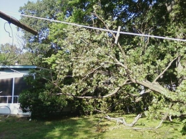
| Storm Damage in the northern neck of Virginia (credit: Nancy Smith) | Storm Damage in Richmond, VA (credit: Richmond Times-Dispatch) | Storm Damage in northern VA (credit: Associated Press) | Damage to a home in Louisa County, VA (credit: Daily Progress) |
Radar
Selected Radar Loops of 0.5° Base Reflectivity/Velocity
 |
 |
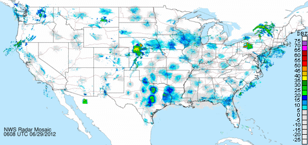
| CONUS 0.5° reflectivity from 2 AM EDT 29 June 2012 through 2 AM EDT 30 June 2012 |
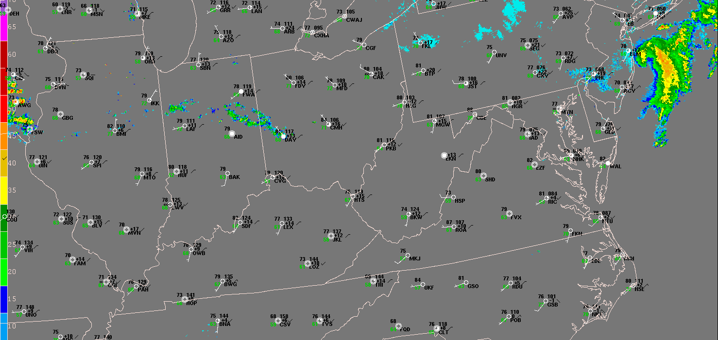
Regional Radar from noon on the 29th through 2 AM. Note the hot temperatures which preceded the storms that afternoon. Heat index values were 110°-115° range during this time! |
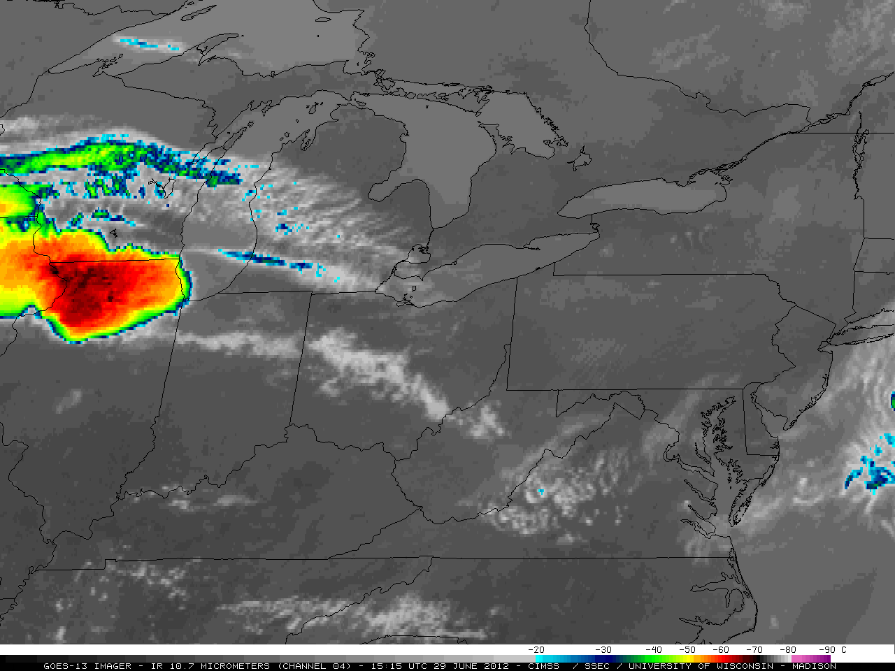 |
| IR Satellite animation from Friday afternoon through Friday night (16 UTC/12 pm EDT 6/29/2012 through 07 UTC/3 am 6/30/2012). IR Satellite measures the cloud top temperature and is used to infer storm intensity. The orange colors represent cloud top temperatures near -60°C while the dark brown and grey colors represent temperatures below -80°C. |
Storm Reports
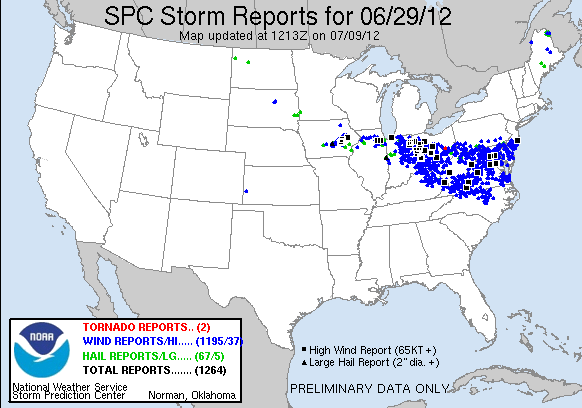 |
| Storm Reports for 29 June 2012 |
----------------------------------------------------------------------------------------------------------
...LOCAL STORM REPORTS JUN 29-30 2012...
1010 PM     TSTM WND DMG     LOUISA                  38.02N  78.00W
06/29/2012                   LOUISA             VA   TRAINED SPOTTER

            TREES DOWN ON COLUMBIA AND LOUISA ROADS

1010 PM     TSTM WND DMG     MINERAL                 38.01N  77.91W
06/29/2012                   LOUISA             VA   TRAINED SPOTTER

            SEVERAL LARGE TREES DOWN IN MINERAL.

1010 PM     TSTM WND DMG     LOUISA                  38.02N  78.00W
06/29/2012                   LOUISA             VA   EMERGENCY MNGR

            SEVERAL LARGE TREES...POWER POLES...POWER LINES AND
            BRANCHES DOWN COUNTY WIDE IN LOUISA COUNTY. TREES
            REPORTED DOWN ON HOMES AND CARS IN MINERAL.

1025 PM     TSTM WND GST     2 ESE DEATONVILLE       37.32N  78.14W
06/29/2012  E60 MPH          AMELIA             VA   TRAINED SPOTTER

            40 MPH GUSTING TO 60 MPH

1030 PM     TSTM WND DMG     SANDY HOOK              37.75N  77.91W
06/29/2012                   GOOCHLAND          VA   PUBLIC

            TREES DOWN IN SANDY HOOK AND HADENSVILLE

1035 PM     TSTM WND DMG     1 SE TUCKAHOE           37.58N  77.58W
06/29/2012                   HENRICO            VA   BROADCAST MEDIA

            LARGE TREE DOWNED AND BLOCKING ROADWAY ON SLEEPY HOLLOW
            RD IN RICHMOND

1040 PM     TSTM WND GST     SHORT PUMP              37.65N  77.61W
06/29/2012  E60 MPH          HENRICO            VA   PUBLIC

            WIND GUSTS ON PARHAM AND PEMBERTON ROADS

1040 PM     TSTM WND DMG     1 WSW SCOTCHTOWN        37.84N  77.61W
06/29/2012                   HANOVER            VA   EMERGENCY MNGR

            LARGE TREES DOWN ON COATESVILLE RD NEAR BEAVERDAM

1040 PM     TSTM WND DMG     JEFFERSON               37.61N  77.90W
06/29/2012                   POWHATAN           VA   AMATEUR RADIO

            TIME IS APPROXIMATE AND BASED ON RADAR ESTIMATE.
            MULTIPLE TREES DOWN AT INTERSECTION OF VA 522 AND VA
            711.

1045 PM     TSTM WND DMG     LUNENBURG               36.96N  78.27W
06/29/2012                   LUNENBURG          VA   AMATEUR RADIO

            TREES DOWN AND BLOCKING VA 723 IN LUNENBURG

1050 PM     TSTM WND GST     2 N PENOLA              37.98N  77.37W
06/29/2012  M60 MPH          CAROLINE           VA   TRAINED SPOTTER

            SEVERAL LARGE TREES DOWN ALONG PENOLA RD

1056 PM     TSTM WND GST     KENBRIDGE               36.96N  78.13W
06/29/2012  M58 MPH          LUNENBURG          VA   MESONET

            58 MPH GUST AT KENBRIDGE

1105 PM     TSTM WND DMG     LAKE CHESDIN PARK       37.27N  77.65W
06/29/2012                   CHESTERFIELD       VA   PUBLIC

            NUMEROUS TREES DOWN AT WHIPPERNOCK MARINA AND
            CAMPGROUND

1125 PM     TSTM WND DMG     1 E FRENCH HAY          37.69N  77.45W
06/29/2012                   HANOVER            VA   EMERGENCY MNGR

            TREES FALLING ON CARS ALONG INTERSTATE 95 NEAR EXIT 86.
            SEVERAL DOWNED TREES WEST OF ASHLAND.

1125 PM     TSTM WND GST     DISPUTANTA              37.12N  77.23W
06/29/2012  E65 MPH          PRINCE GEORGE      VA   TRAINED SPOTTER

            NUMEROUS TREES DOWN

1140 PM     TSTM WND DMG     WAKEFIELD               36.97N  76.99W
06/29/2012                   SUSSEX             VA   NWS OFFICE

            LARGE TREE BRANCHES PARTIALLY BLOCKING US 460

1145 PM     TSTM WND GST     GLOUCESTER              37.41N  76.53W
06/29/2012  M60 MPH          GLOUCESTER         VA   TRAINED SPOTTER

            NUMEROUS TREES DOWNED ALONG HIGHWAY 14...NE OF
            GLOUCESTER

1153 PM     TSTM WND GST     FRANKLIN                36.68N  76.94W
06/29/2012  M71 MPH          CITY OF FRANKLIN   VA   TRAINED SPOTTER

1155 PM     TSTM WND DMG     JAMESTOWN               37.22N  76.76W
06/29/2012                   JAMES CITY         VA   AMATEUR RADIO

            LARGE TREE DOWNED BLOCKING ROAD NEAR INTERSECTION OF
            GREEN SPRINGS AND TYLER IN JAMESTOWN

1155 PM     TSTM WND GST     FRANKLIN/J_B_ROSE       36.70N  76.90W
06/29/2012  M74 MPH          ISLE OF WIGHT      VA   ASOS

1155 PM     TSTM WND DMG     CAMBRIDGE               38.56N  76.08W
06/29/2012                   DORCHESTER         MD   PUBLIC

            TIME IS APPROXIMATE AND BASED ON RADAR ESTIMATE.
            NUMEROUS TREES DOWN...AWNING BLOWN OFF RESIDENCE IN
            CAMBRIDGE CREEK

1156 PM     TSTM WND GST     FORT EUSTIS             37.13N  76.62W
06/29/2012  M63 MPH          CITY OF NEWPORT NE VA   ASOS

1200 AM     TSTM WND GST     WINDSOR                 36.81N  76.74W
06/30/2012  M62 MPH          ISLE OF WIGHT      VA   TRAINED SPOTTER

1208 AM     TSTM WND DMG     SALISBURY               38.37N  75.59W
06/30/2012                   WICOMICO           MD   PUBLIC

            NUMEROUS TREES DOWN IN SALISBURY

1210 AM     TSTM WND GST     GATES                   36.50N  76.77W
06/30/2012  E60 MPH          GATES              NC   PUBLIC

1210 AM     MARINE TSTM WIND STINGRAY POINT          37.55N  76.25W
06/30/2012  M61 MPH          ANZ631             VA   BUOY

1210 AM     TSTM WND DMG     SMITHFIELD              36.98N  76.62W
06/30/2012                   ISLE OF WIGHT      VA   NWS EMPLOYEE

            TREES DOWN...ESTIMATED WIND GUST 60 MPH

1212 AM     MARINE TSTM WIND RAPPAHANNOCK LIGHT      37.54N  76.02W
06/30/2012  M63 MPH          ANZ631             VA   BUOY

1217 AM     TSTM WND DMG     GRAFTON                 37.16N  76.47W
06/30/2012                   YORK               VA   PUBLIC

            LARGE OAK TREE DOWN WITH SEVERAL ADDITIONAL LARGE
            BRANCHES DOWN IN GRAFTON.

1218 AM     MARINE TSTM WIND YORKTOWN                37.23N  76.48W
06/30/2012  M34 MPH          YORK               VA   BUOY

1224 AM     TSTM WND GST     PORTSMOUTH              36.84N  76.30W
06/30/2012  M61 MPH          CITY OF PORTSMOUTH VA   COUNTY OFFICIAL

            61 MPH GUST MEASURED AT PORTSMOUTH EOC

1230 AM     TSTM WND DMG     DOZIERS CORNER          36.76N  76.27W
06/30/2012                   CITY OF CHESAPEAKE VA   TRAINED SPOTTER

            MULTIPLE TREES DOWN.

1230 AM     MARINE TSTM WIND 1 S SUSSEX AT HAMPTON   36.99N  76.35W
06/30/2012  M49 MPH          ANZ632             VA   BUOY

            43 KT GUSTS AT HAMPTON FLATS

1230 AM     TSTM WND GST     KIPTOPEKE               37.14N  75.96W
06/30/2012  M58 MPH          NORTHAMPTON        VA   MESONET

1230 AM     TSTM WND GST     CHESA BAY BRDG TNL      36.97N  76.11W
06/30/2012  M66 MPH          ANZ634             VA   BUOY

1230 AM     TSTM WND DMG     CRISFIELD               37.98N  75.86W
06/30/2012                   SOMERSET           MD   COUNTY OFFICIAL

            NUMEROUS TREES DOWN

1230 AM     TSTM WND DMG     1 SW PHOEBUS            37.01N  76.33W
06/30/2012                   CITY OF HAMPTON    VA   PUBLIC

            TREES DOWN ON MALLORY RD

1242 AM     MARINE TSTM WIND 1 N CAPE HENRY          36.94N  76.01W
06/30/2012  M63 MPH          ANZ634             VA   BUOY

1242 AM     TSTM WND GST     NWLON CAPE HENRY        36.93N  76.01W
06/30/2012  M63 MPH          CITY OF VIRGINIA B VA   BUOY

1242 AM     MARINE TSTM WIND OCEAN CITY INLET        38.33N  75.09W
06/30/2012  M46 MPH          WORCESTER          MD   BUOY

1243 AM     TSTM WND GST     OCEANA NAS              36.82N  76.03W
06/30/2012  M61 MPH          CITY OF VIRGINIA B VA   ASOS

1250 AM     TSTM WND DMG     BAY COLONY              38.40N  75.16W
06/30/2012                   WORCESTER          MD   PUBLIC

            LARGE TREE ON HOME IN OCEAN PINES WITH SEVERAL
            ADDITIONAL TREES DOWN.

0100 AM     MARINE TSTM WIND CHESAPEAKE LS           36.90N  75.72W
06/30/2012  M55 MPH          ANZ656             VA   BUOY
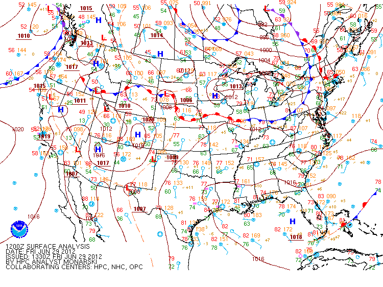
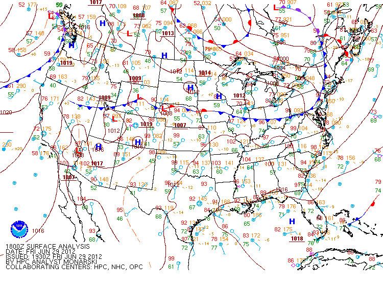
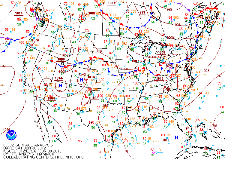
Environment
Synoptic Surface Summary from WPC Analysis.
 |
 |
 |
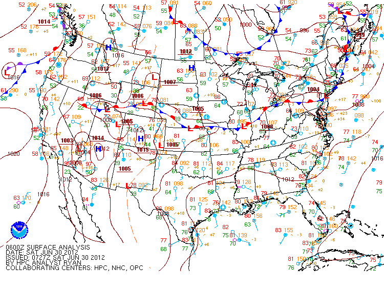 |
| 29Jun2012 12z/8 AM EDT | 29Jun2012 18z/2 PM EDT | 29Jun2012 00z/8 PM EDT | 30Jun2012 06z/2 AM EDT |
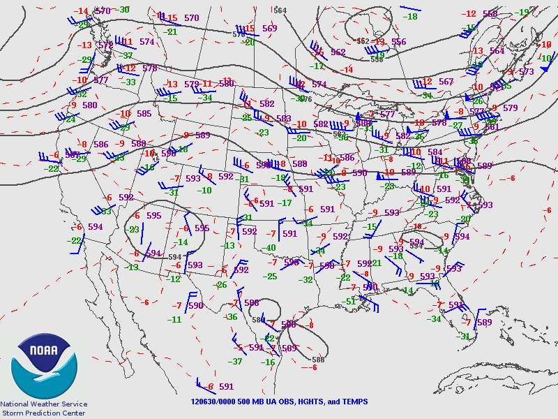
June 30 2012 00z/8 PM EDT Upper Level Synoptic Snapshot.
 |
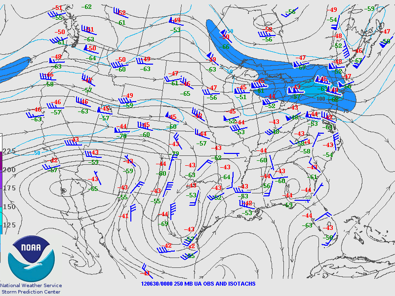 |
| 500 mb Analysis | 250 mb Analysis |
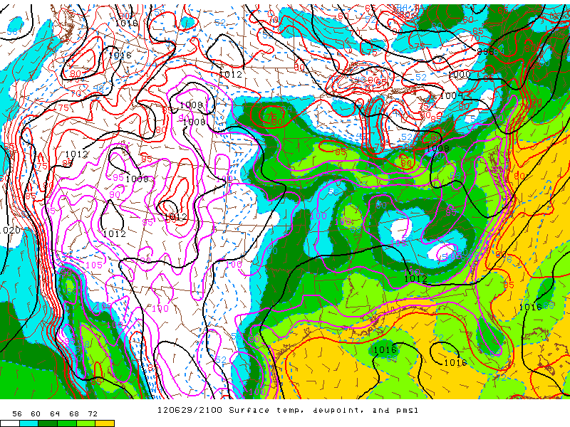
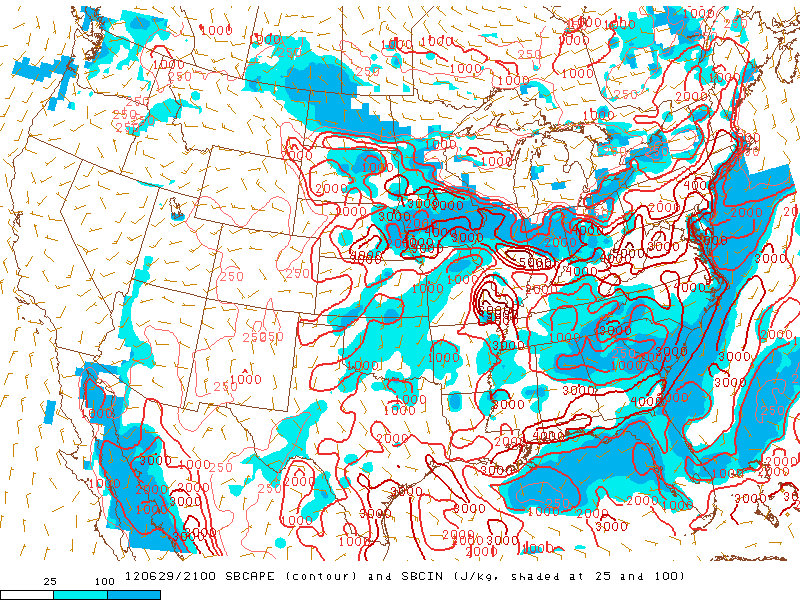
Near Storm Environment Summary.
 |
 |
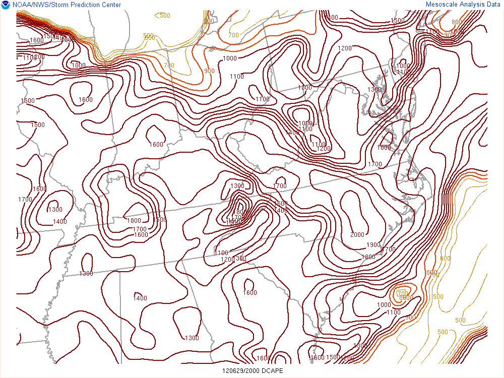 |
| 21z/5 PM EDT T/Td/MSLP/Wind | 21z/5 PM MLCAPE/MLCIN | 21z/5 PM DCAPE |
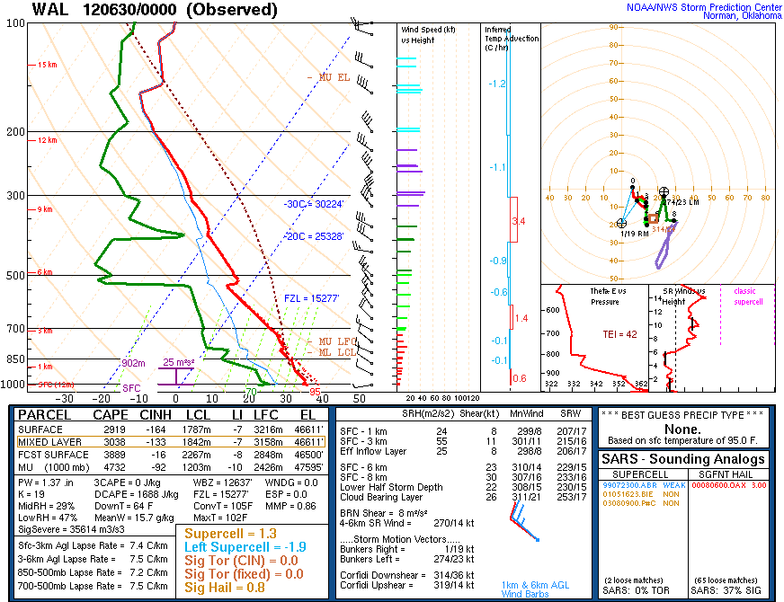
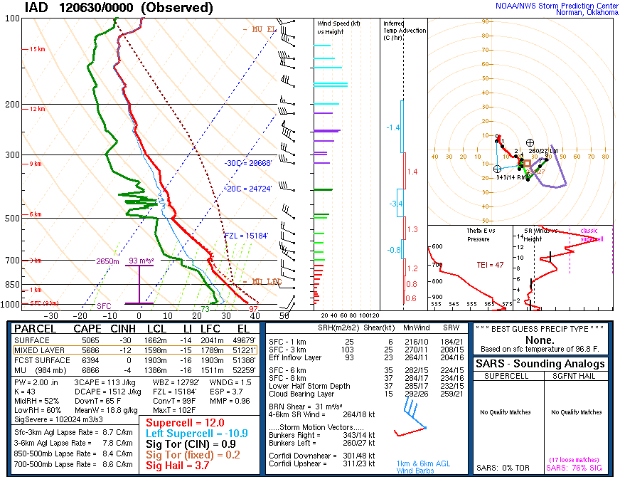
Environmental Sounding data
 |
 |
 |
| 00z/8 PM Sounding from Wallops (WAL) |
00z/8 PM Sounding from Dulles (IAD) Note the 2" PW and more than 5000 J/kg of MLCAPE, indicating very strong instability, forcing, and lift! |
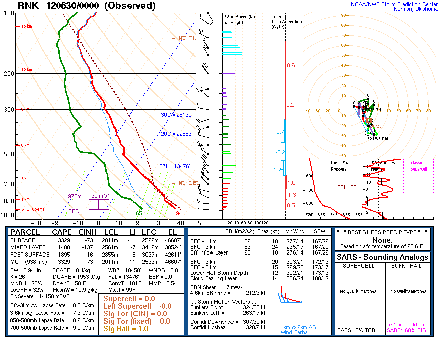
00z/8 PM RNK Sounding |
 |
Media use of NWS Web News Stories is encouraged! Please acknowledge the NWS as the source of any news information accessed from this site. |
|


 Coastal Flood
 Heat
Heat