Overview
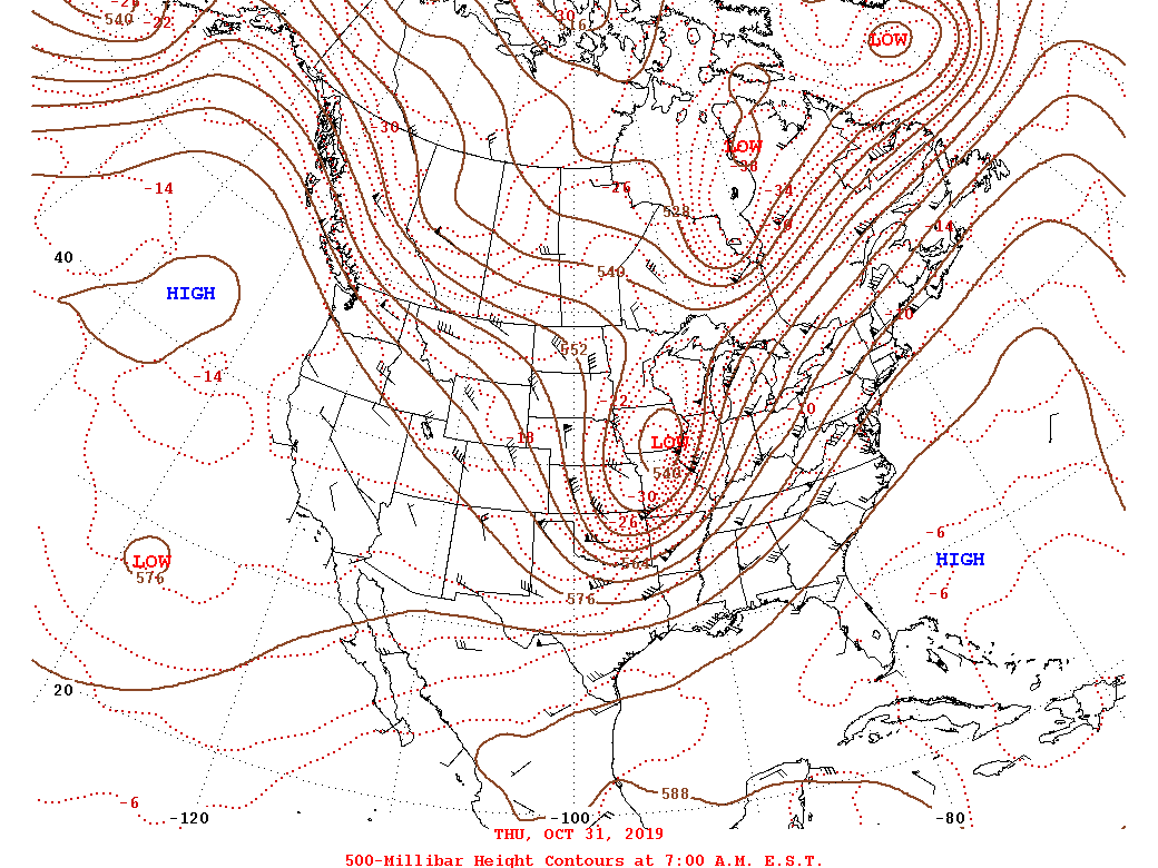
A deep, positively tilted upper trough was positioned from south-central Canada to the eastern Rockies on the morning of October 30th. The trough moved northeastward into the Upper Midwest by the morning of the 31st (and started to become neutral, then negatively tilted). At the same time, surface low pressure in the Southern Plains was rapidly deepening as it tracked into the Ohio Valley. A trailing cold front was positioned from KY to the north-central Gulf of America during the morning of the 31st. Ahead of the front, temperatures (and dew points) were already in the 60s across our CWA, with 70 degree dew points in the Carolinas. The airmass behind the cold front was anomalously cold for the end of October (several inches of snow fell over parts of the Midwest). A line of showers (with gusty winds) was located along the cold front. Rapid cyclogenesis continued as the low tracked northeastward toward New England. This allowed for the cold front to rapidly move to the east (reaching the mountains of VA by early evening on 10/31). Temperatures were in the mid 70s-low 80s across the area, with dew points around 70°. By this time, a line of thunderstorms had developed across the western Carolinas (in a warm, moisture rich airmass with moderate instability). These thunderstorms developed slightly ahead of the cold front/aforementioned line of showers.
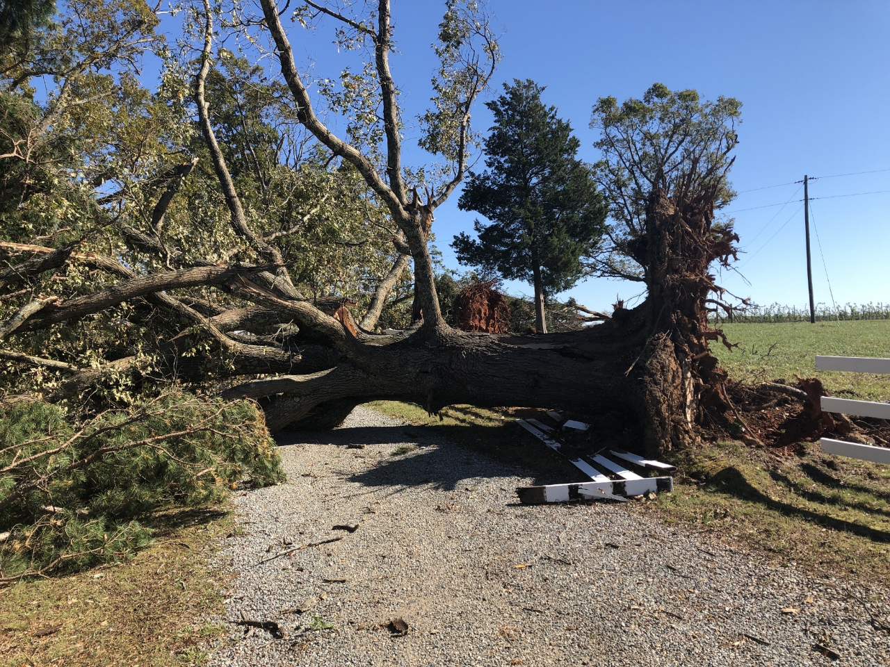
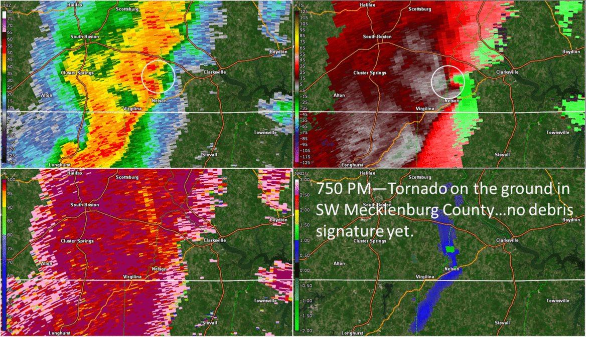
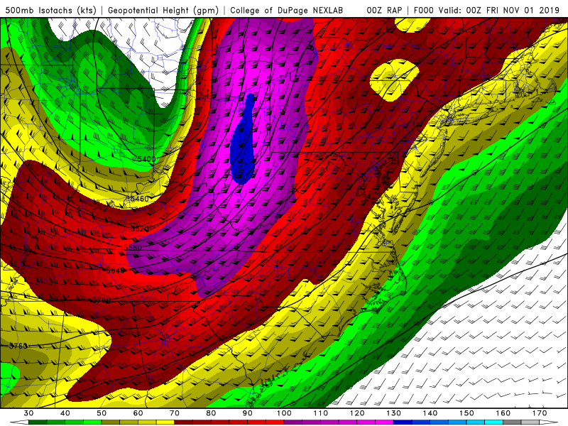
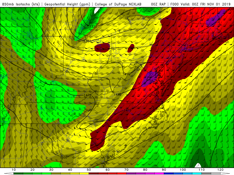
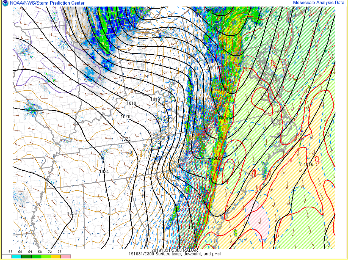
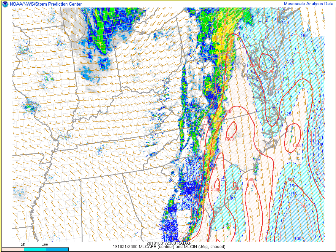
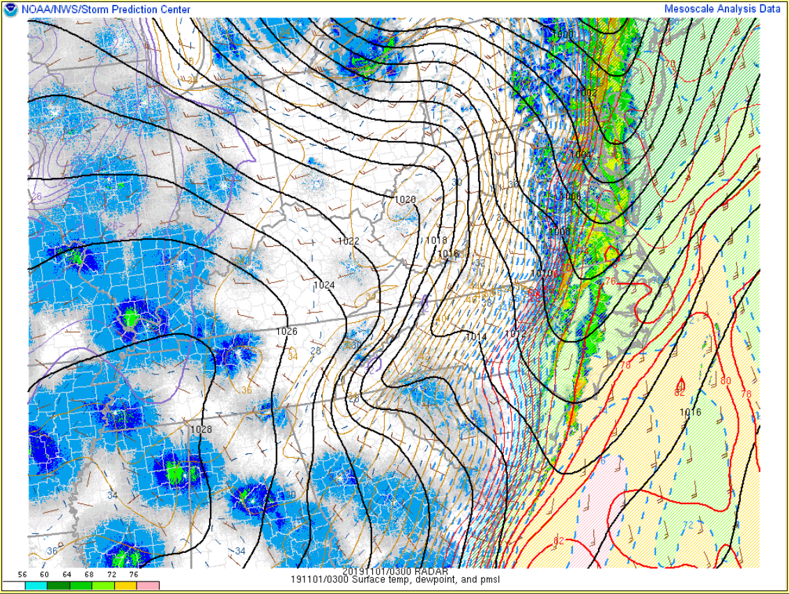
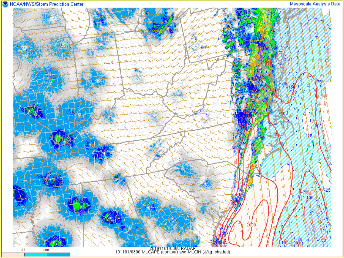
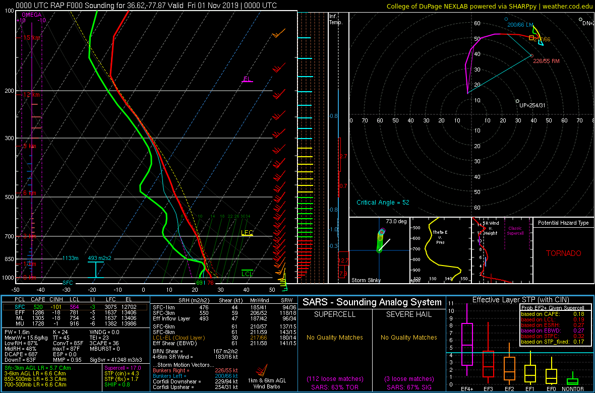
By 7 PM on the evening of the 31st, the pre-frontal line of thunderstorms had tracked to the northeast, and was now positioned from the southern VA Piedmont (just W of our CWA) to the central Carolinas. With a strengthening low to our N and a strong cold front approaching from the W, it is not a surprise that the low-mid level kinematics were favorable for damaging winds and a few tornadoes. While surface winds were largely out of the south, a strong (50 kt) south-southwesterly 925 mb jet was positioned over our area. This resulted in 300-500 m2/s2 of 0-1 km SRH. Deep layer shear was present from the surface to the mid levels (500 mb winds were SW at 70-90 kt). Marginal-moderate instability (500-1500 J/kg of MLCAPE...highest south) was present over our CWA during the evening. As the line crossed our western CWA boundary (just before 8 PM), one of the cells produced an EF-1 tornado in the southwestern part of Mecklenburg County, VA. The pre-frontal line slowly weakened as it approached central VA (likely due to slowly waning instability) and had nearly fallen apart by 10 PM. Meanwhile, the actual cold front (and line of showers along it) was tracking eastward across the VA Piedmont by 10 PM. Widespread gusts of 35-45 mph were measured at AWOS sites across the VA Piedmont as the line tracked through. The line increased in intensity as it tracked through central VA, with gusts up to 50 mph measured (with a 51 mph gust at RIC). Additional strengthening occurred as the line tracked through the Lower MD Eastern Shore/eastern VA/NE NC, with some bowing segments noted. This may have been due to a strengthening south-southwesterly 925 mb jet (65-70 kt by midnight across coastal areas). In addition to widespread 50-60 mph (measured) wind gusts, a tornado (EF-1) briefly touched down in the southern part of the City of Chesapeake. A few gusts of 65-70 mph were measured at two near-surface marine sites (Dominion Terminal on the Lower James River and Ocean City).
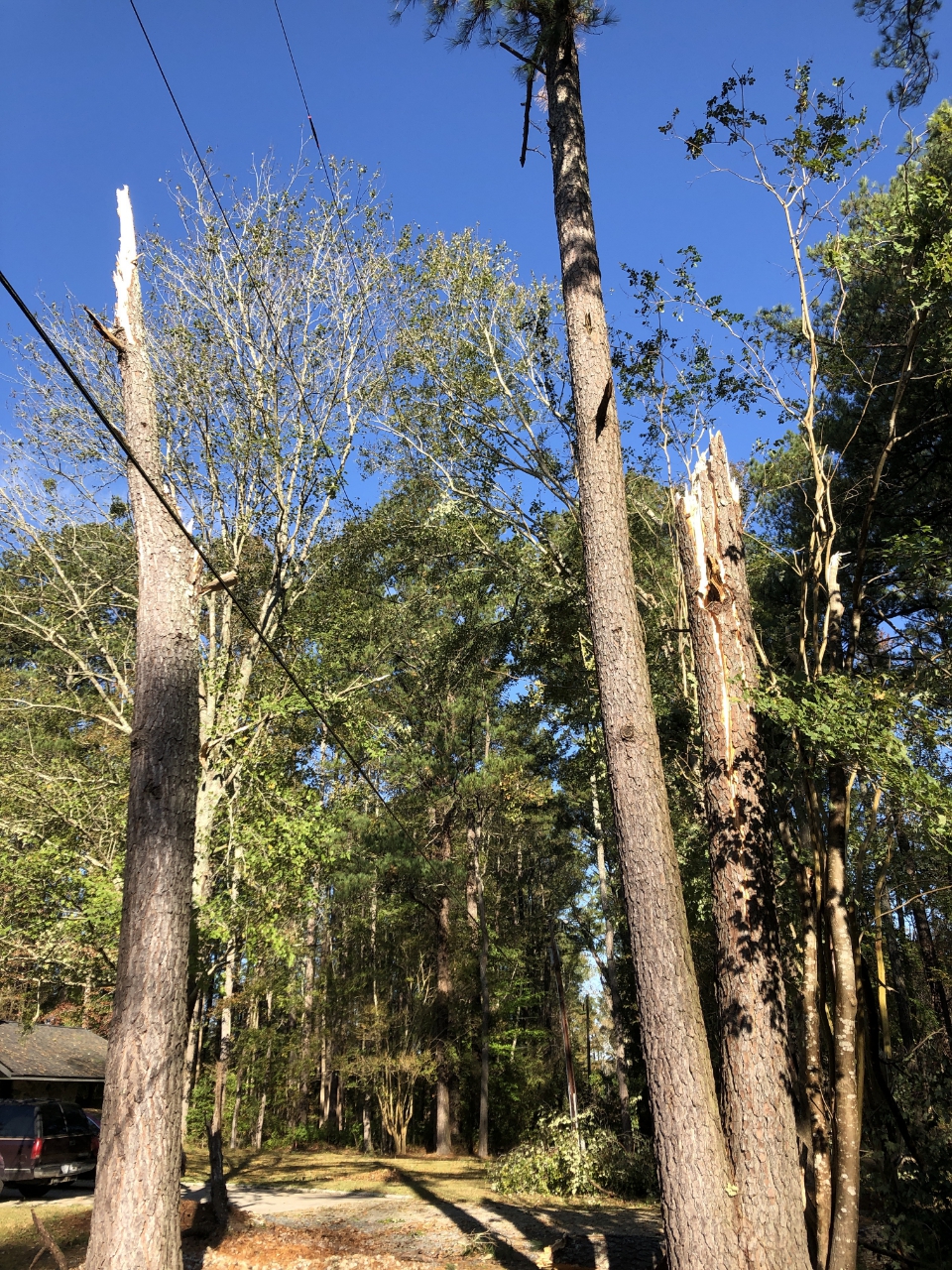
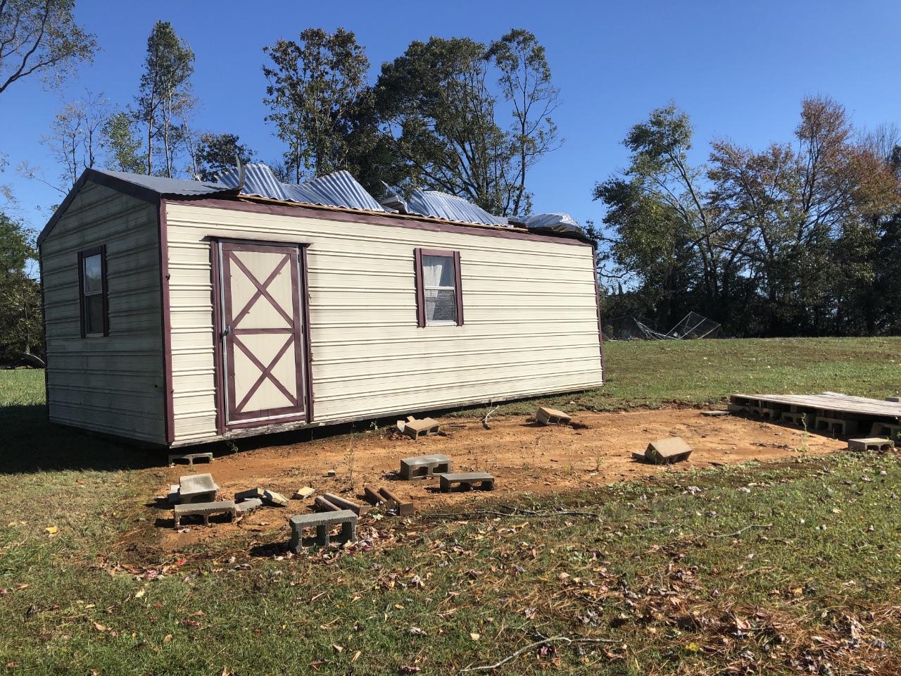
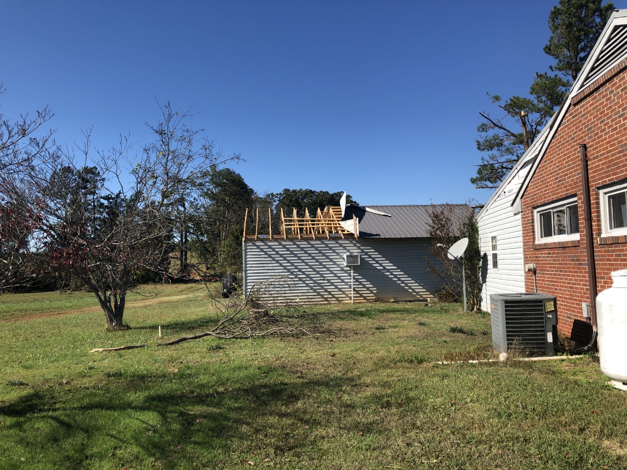
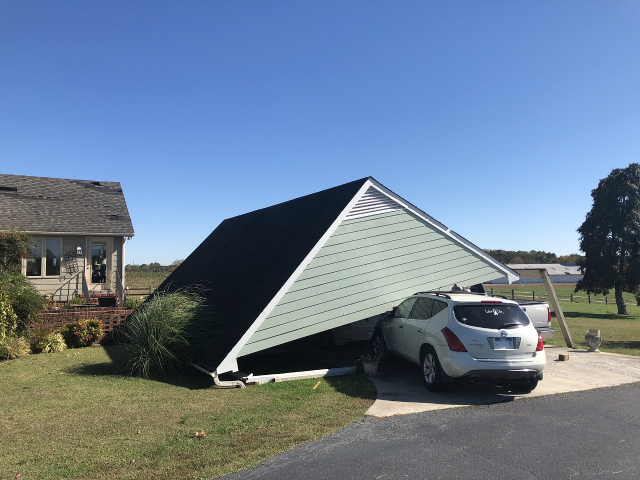
The widespread wind resulted in areas of downed trees and power lines (especially across SE VA and the Lower MD Eastern Shore). In addition, there were a few reports of minor structural damage due to the intense straight line winds.
Tornadoes:
|
Tornado - Southwest Mecklenburg
Track Map 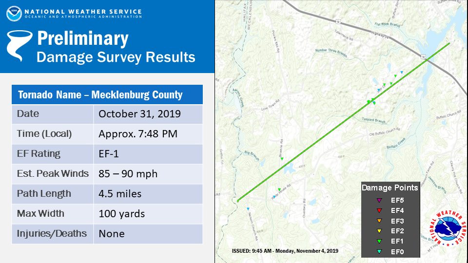 
Downloadable KMZ File |
||||||||||||||||
|
Tornado - Southern Chesapeake
Track Map 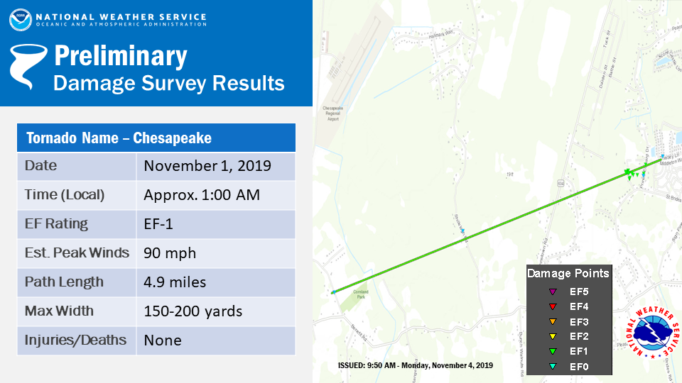
Downloadable KMZ File |
||||||||||||||||
The Enhanced Fujita (EF) Scale classifies tornadoes into the following categories:
| EF0 Weak 65-85 mph |
EF1 Moderate 86-110 mph |
EF2 Significant 111-135 mph |
EF3 Severe 136-165 mph |
EF4 Extreme 166-200 mph |
EF5 Catastrophic 200+ mph |
 |
|||||
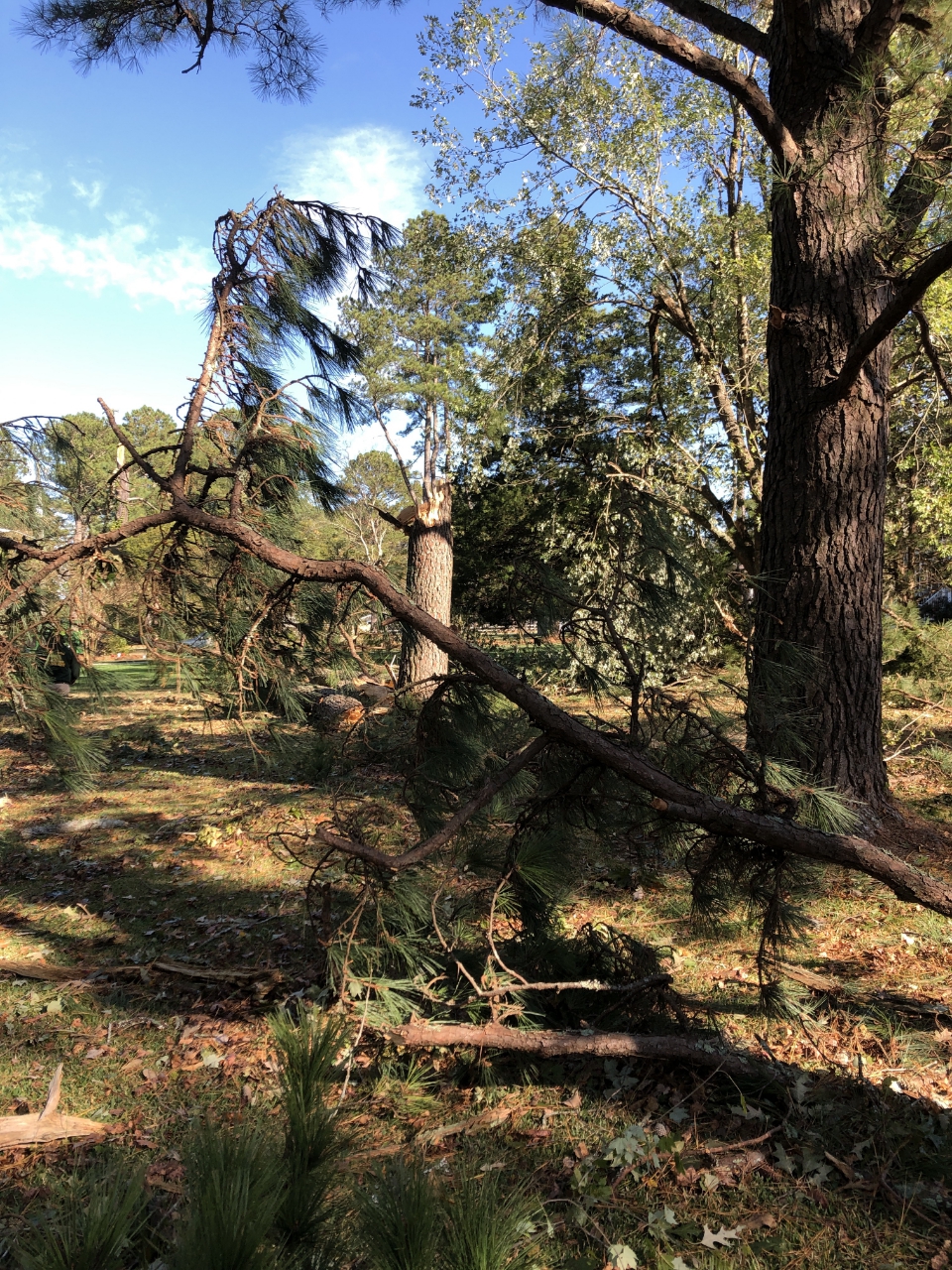
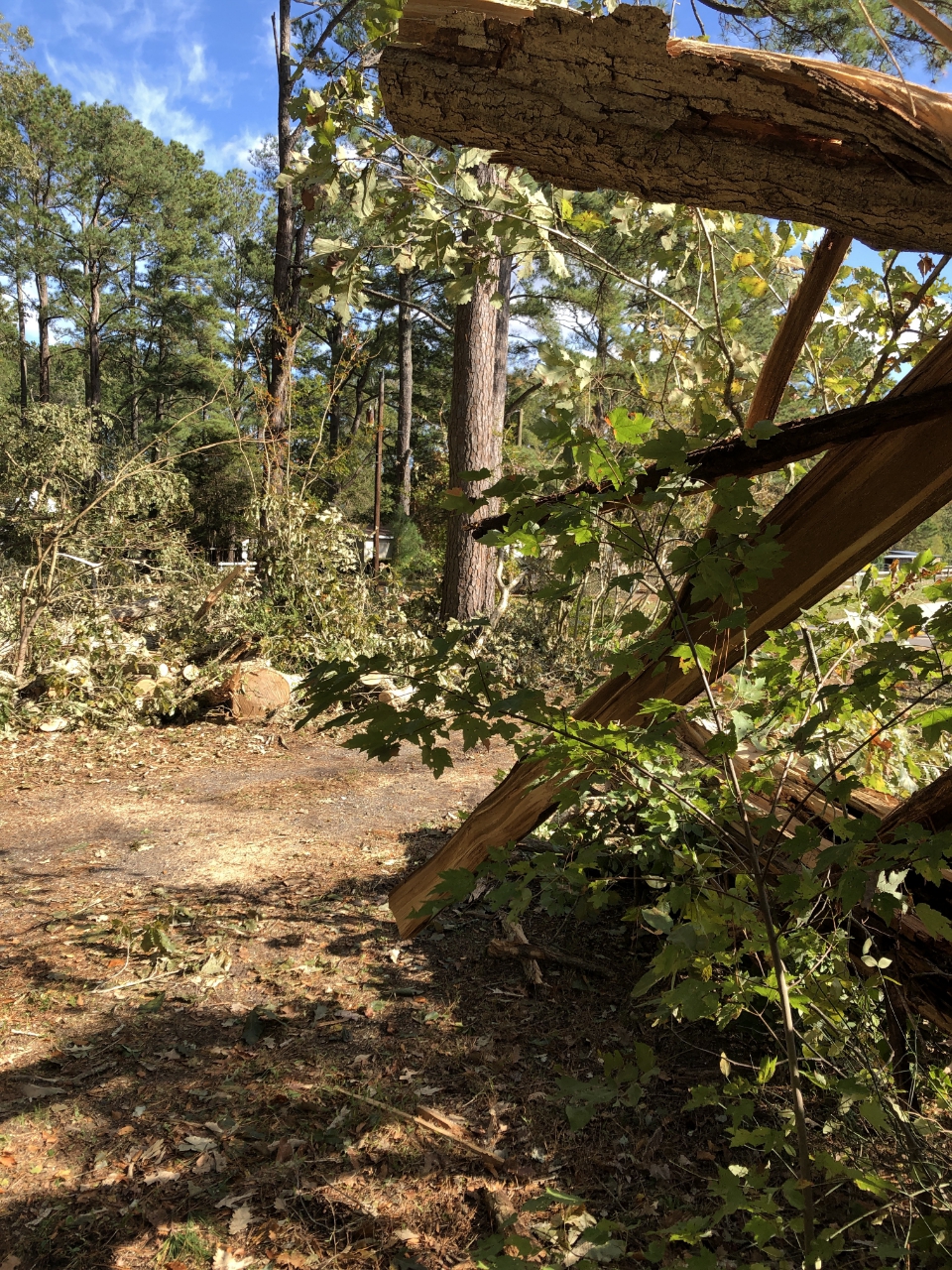
Photos
Chesapeake Tornado
 |
 |
 |
 |
| Dewald Rd (NWS Survey) |
Dewald Rd (NWS Survey) |
Dewald Rd (NWS Survey) |
Shillelagh Rd (NWS Survey) |
Mecklenburg Tornado
 |
 |
 |
 |
| Bowens Rd (NWS Survey) |
Hite Rd (NWS Survey) |
Hite Rd (NWS Survey) |
Hite Rd (NWS Survey) |
Radar
Animated Radar Images from the Two Tornadoes in the AKQ CWA
 |
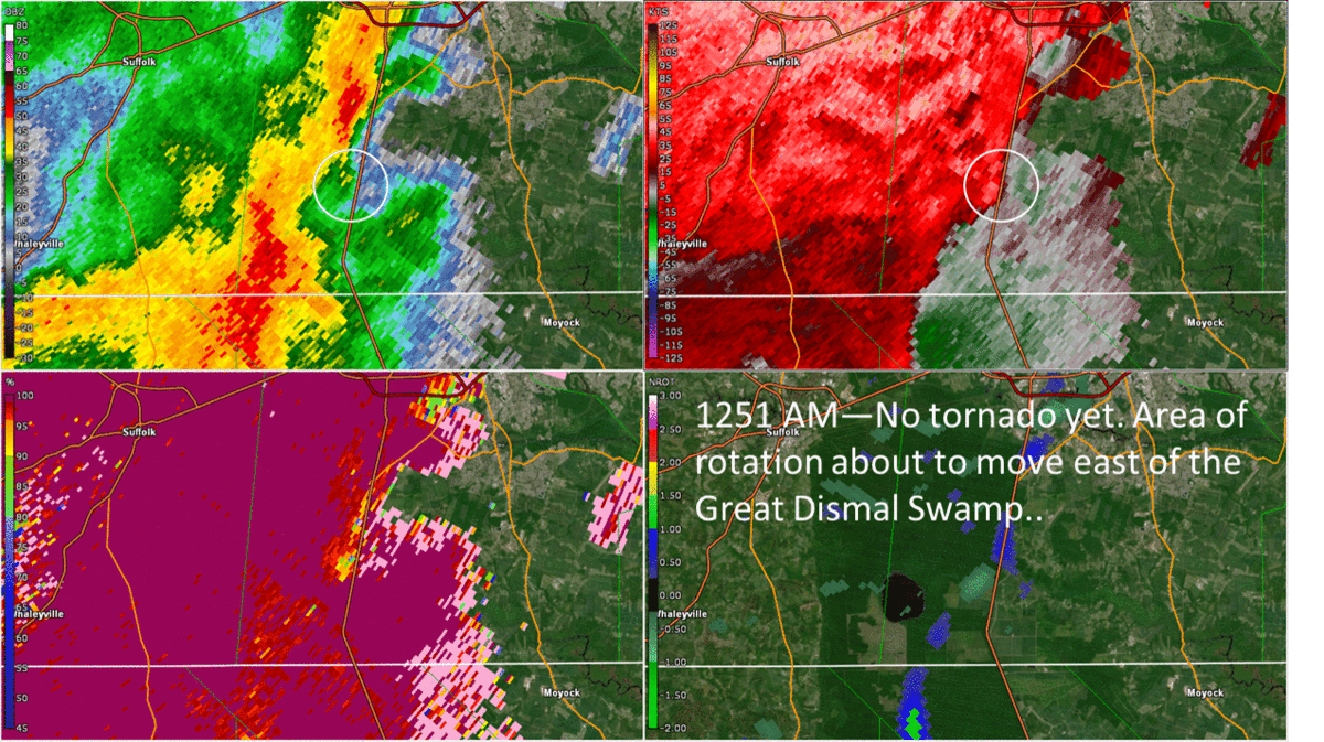 |
| Animated Radar Sequence of SW Mecklenburg Tornado from KRAX radar. Top Left: 0.2° Reflectivity. Top Right: 0.2° Base Velocity. Bottom Left: 0.2° Correlation Coefficient. | Animated Radar Sequence of Chesapeake Tornado from KAKQ radar. Top Left: 0.5° Reflectivity. Top Right: 0.5° Base Velocity. Bottom Left: 0.5° Correlation Coefficient. |
Additional Storm Reports
PRELIMINARY LOCAL STORM REPORT...SUMMARY
NATIONAL WEATHER SERVICE WAKEFIELD VA
403 PM EDT FRI NOV 1 2019

..TIME...   ...EVENT...      ...CITY LOCATION...     ...LAT.LON...
..DATE...   ....MAG....      ..COUNTY LOCATION..ST.. ...SOURCE....
            ..REMARKS..

1241 AM     TSTM WND GST     WARDS CORNER            36.92N 76.27W
11/01/2019  M59 MPH          CITY OF NORFOLK    VA   AWOS

            AWOS STATION KNGU NORFOLK NAS CHAM.

1240 AM     TSTM WND GST     3 SSE TANGIER           37.79N 75.97W
11/01/2019  M76 MPH          ACCOMACK           VA   MESONET

            MESONET STATION XTSL TANGIER SOUND LIGHT.

0814 PM     TSTM WND GST     3 ENE ROGERS CORNER     36.73N 78.36W
10/31/2019  M55 MPH          MECKLENBURG        VA   TRAINED SPOTTER


0102 AM     TSTM WND DMG     ONLEY                   37.69N 75.71W
11/01/2019                   ACCOMACK           VA   911 CALL CENTER

            TREE ON POWERLINES ON PENNSYLVANIA AVE. IN
            ONLEY.

0101 AM     TSTM WND DMG     WILLARDS                38.39N 75.35W
11/01/2019                   WICOMICO           MD   911 CALL CENTER

            TREES AND POWERLINES DOWN IN AROUND
            WILLARDS.

0101 AM     TSTM WND DMG     POWELLVILLE             38.33N 75.38W
11/01/2019                   WICOMICO           MD   911 CALL CENTER

            TREES AND POWERLINES DOWN AROUND
            POWELLVILLE.

0101 AM     TSTM WND DMG     1 SSW BAY VIEW          37.27N 75.97W
11/01/2019                   NORTHAMPTON        VA   911 CALL CENTER

            LARGE TREE DOWN ON LANKFORD HWY.

1244 AM     TSTM WND DMG     1 E FRUITLAND           38.32N 75.61W
11/01/2019                   WICOMICO           MD   911 CALL CENTER

            TRANSFORMER FIRE IN FRUITLAND.

1244 AM     TSTM WND DMG     SALISBURY               38.37N 75.59W
11/01/2019                   WICOMICO           MD   911 CALL CENTER

            TREES AND POWERLINES DOWN IN SALISBURY.

1235 AM     TSTM WND DMG     ALLEN                   38.29N 75.69W
11/01/2019                   WICOMICO           MD   911 CALL CENTER

            POWERLINES DOWN ALONG ALLEN ROAD.

0914 PM     TSTM WND DMG     ALBERTA                 36.86N 77.88W
10/31/2019                   BRUNSWICK          VA   911 CALL CENTER

            A FEW TREES AND POWERLINES DOWN IN BRUNSWICK
            COUNTY.

0845 PM     TSTM WND DMG     GOOCHLAND               37.68N 77.89W
10/31/2019                   GOOCHLAND          VA   911 CALL CENTER

            A FEW TREES DOWN THROUGHOUT GOOCHLAND
            COUNTY.

0845 PM     TSTM WND DMG     LOUISA                  38.02N 78.00W
10/31/2019                   LOUISA             VA   911 CALL CENTER

            TREES DOWN THROUGHOUT LOUISA COUNTY.

0815 PM     TSTM WND DMG     BOYDTON                 36.67N 78.39W
10/31/2019                   MECKLENBURG        VA   911 CALL CENTER

            TREES DOWN THROUGHOUT MECKLENBURG COUNTY.
            TIME ESTIMATED FROM RADAR.

0810 PM     TSTM WND DMG     PALMYRA                 37.86N 78.26W
10/31/2019                   FLUVANNA           VA   911 CALL CENTER

            MULTIPLE TREES DOWN THROUGHOUT THE COUNTY.
            TIME ESTIMATED FROM RADAR.

0800 PM     TSTM WND DMG     3 NNW SHORES            37.78N 78.38W
10/31/2019                   FLUVANNA           VA   911 CALL CENTER

            TREE DOWN ON A RESIDENCE ON ROCKFISH RUN
            ROAD.

0113 AM     TSTM WND DMG     1 NE BERLIN             38.34N 75.21W
11/01/2019                   WORCESTER          MD   BROADCAST MEDIA

            ROOF DAMAGE AT KELLY FOODS CORPORATION.

0112 AM     TSTM WND DMG     1 NNE BERLIN            38.34N 75.21W
11/01/2019                   WORCESTER          MD   BROADCAST MEDIA

            TREES DOWN AT ATLANTIC GENERAL HOSPITAL.

1239 AM     TSTM WND DMG     1 NNE CHURCHLAND        36.88N 76.39W
11/01/2019                   CITY OF PORTSMOUTH VA   BROADCAST MEDIA

            FRONT PORCH ROOF DAMAGED AT A RESIDENCE ON
            QUEENSWOOD DR. IN PORTSMOUTH.

1231 AM     TSTM WND DMG     1 WSW LANGLEY VIEW      37.06N 76.38W
11/01/2019                   CITY OF HAMPTON    VA   BROADCAST MEDIA

            TREE ON A HOUSE AT MICHAEL ST. AND DEERFIELD
            BLVD. IN HAMPTON.

1255 AM     TSTM WND DMG     2 SE CHESAPEAKE AIRPORT 36.64N 76.29W
11/01/2019                   CITY OF CHESAPEAKE VA   DEPT OF HIGHWAYS

            2200 BLOCK OF SHILLELAGH CLOSED DUE TO
            DOWNED POWERLINES AND A LARGE TREE BLOCKING
            THE ROAD.

0120 AM     TSTM WND DMG     3 NE OCEAN PINES        38.42N 75.12W
11/01/2019                   WORCESTER          MD   PUBLIC

            DAMAGE AT AN RV PARK ALONG ST. MARTINS NECK
            RD.

0111 AM     TSTM WND DMG     3 NW MOYOCK             36.51N 76.18W
11/01/2019                   CURRITUCK          NC   PUBLIC

            ROOF DAMAGE IN MOYOCK.

1144 PM     TSTM WND DMG     2 WNW DENDRON           37.04N 76.95W
10/31/2019                   SURRY              VA   PUBLIC

            CORRECTS PREVIOUS TSTM WND DMG REPORT FROM 2
            WNW DENDRON. LARGE TREES UPROOTED AT A
            RESIDENCE NEAR DENDRON.

1142 PM     TSTM WND DMG     4 W DENDRON             37.03N 77.00W
10/31/2019                   SUSSEX             VA   PUBLIC

            SEVERAL TREES DOWN IN SPRING HILL NEAR
            WAKEFIELD.

1258 AM     TSTM WND DMG     2 SW HICKORY            36.65N 76.25W
11/01/2019                   CITY OF CHESAPEAKE VA   TRAINED SPOTTER

            TREES SNAPPED ALONG DEWALD RD. IN THE
            HICKORY AREA OF THE CITY OF CHESAPEAKE.
            NUMEROUS TREES DOWN, SOME ON HOUSES AND ON A
            MOTOR HOME. THE AREA OF DAMAGE WAS ABOUT 300
            FT. WIDE AND 1000 FT. LONG. POSSIBLE
            TORNADO.

1258 AM     TSTM WND DMG     2 SW HICKORY            36.64N 76.25W
11/01/2019                   CITY OF CHESAPEAKE VA   UTILITY COMPANY

            NUMEROUS POWER OUTAGES DUE TO STORM DAMAGE
            IN THE HICKORY AREA OF CHESAPEAKE.

0116 AM     MARINE TSTM WIND 1 ENE RUDEE HEIGHTS     36.83N 75.97W
11/01/2019  M54 MPH          ANZ656             VA   MESONET

            MESONET STATION XRUD RUDEE INLET.

0106 AM     MARINE TSTM WIND 5 NW SILVER BEACH       37.54N 76.02W
11/01/2019  M53 MPH          ANZ631             VA   MESONET

            MESONET STATION RPLV2 RAPPAHANNOCK LIGHT.

1242 AM     MARINE TSTM WIND 2 SSW FORT MONROE       36.98N 76.32W
11/01/2019  M63 MPH          ANZ638             VA   MESONET

            MESONET STATION WDSV2 WILLOUGHBY DEGUASSING
            STATION.

1241 AM     MARINE TSTM WIND 4 SSW RALEIGH TERRACE   36.95N 76.39W
11/01/2019  M58 MPH          ANZ638             VA   MESONET

            MESONET STATION XMGL MIDDLE GROUND
            LIGHTHOUSE.

1236 AM     MARINE TSTM WIND 4 SW RALEIGH TERRACE    36.96N 76.42W
11/01/2019  M67 MPH          ANZ638             VA   MESONET

            MESONET STATION DOMV2 DOMINION TERMINAL.

0124 AM     MARINE TSTM WIND 2 SE WEST OCEAN CITY    38.33N 75.08W
11/01/2019  M65 MPH          ANZ650             MD   MESONET

            MESONET STATION XOCN OCEAN CITY.

0103 AM     MARINE TSTM WIND 1 WSW CAPE CHARLES      37.26N 76.03W
11/01/2019  M52 MPH          ANZ632             VA   MESONET

            MESONET STATION XPLT PLANTATION FLATS.

1254 AM     MARINE TSTM WIND 8 SW FISHERMANS ISLAND  37.03N 76.08W
11/01/2019  M72 MPH          ANZ632             VA   MESONET

            MESONET STATION CHBV2 8 NW CAPE HENRY.

1236 AM     MARINE TSTM WIND 4 ESE MARYUS            37.25N 76.33W
11/01/2019  M56 MPH          ANZ632             VA   MESONET

            MESONET STATION YKRV2 YORK RIVER EAST REAR
            RANGE LIGHT.
Environment
Upper Level Synoptic Summary.
 |
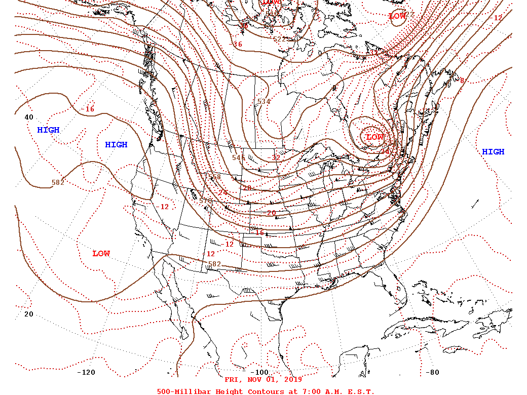 |
| 10/31 12z/8 AM EDT 500 mb Analysis | 11/1 12z/8 AM EDT 500 mb Analysis |
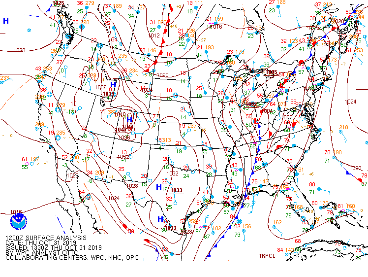
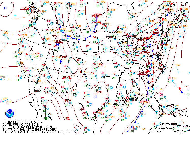
Synoptic Surface summary.
 |
 |
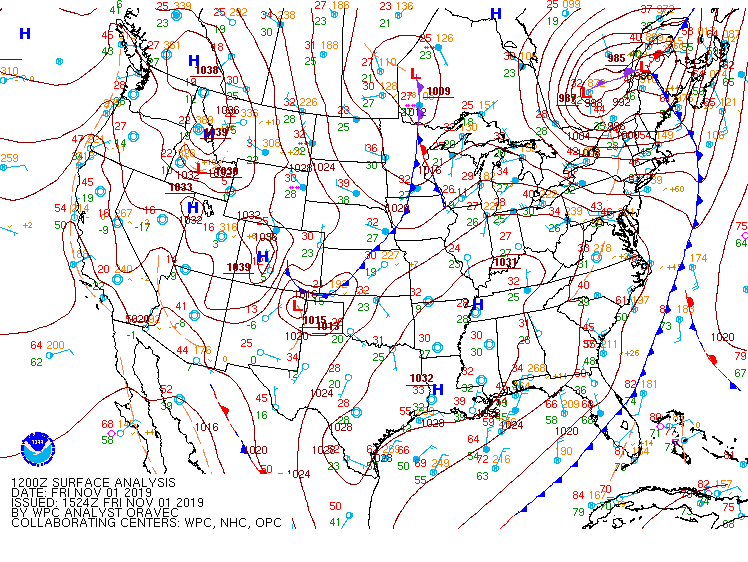 |
| 10/31 12z/8 AM EDT WPC Surface Analysis | 10/31 8 PM EDT (11/1 0z) WPC Surface Analysis | 11/1 12z/8 AM EDT WPC Surface Analysis |
Evening (00z/8 PM EDT) Upper Air RAP Analyses
 |
 |
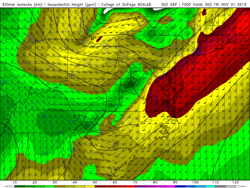 |
| 500 mb Heights/Winds | 850 mb Heights/Winds | 925 mb Heights/Winds |
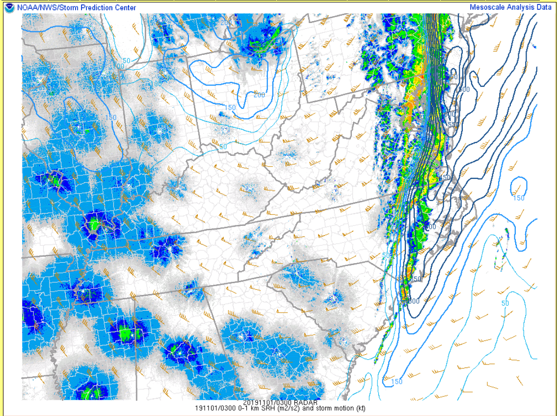
23z/7 PM EDT Mesoanalysis/Selected Parameters
 |
 |
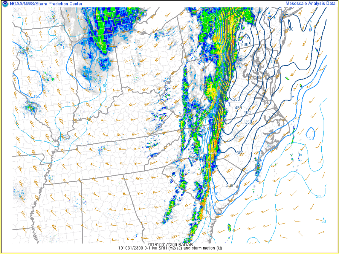 |
| MSLP/T/Td/Wind | MLCAPE/MLCIN | 0-1 km SRH |
03z/11 PM EDT Mesoanalysis/Selected Parameters
 |
 |
 |
| MSLP/T/Td/Wind | MLCAPE/MLCIN | 0-1 km SRH |
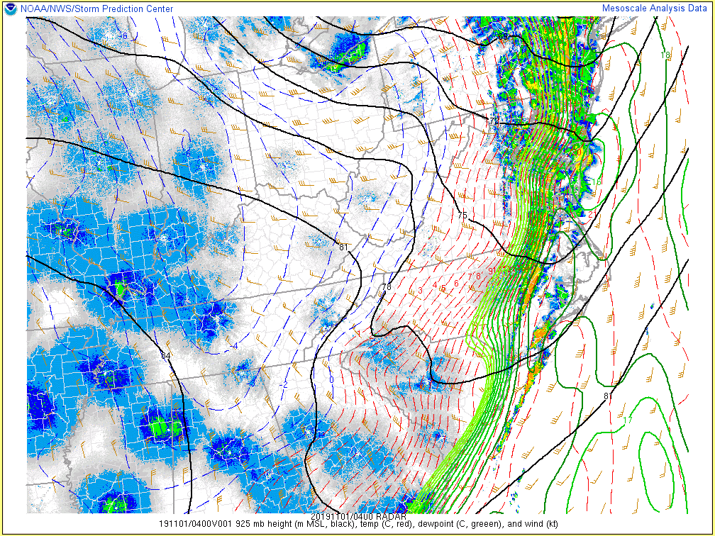
Additional environmental data.
 |
 |
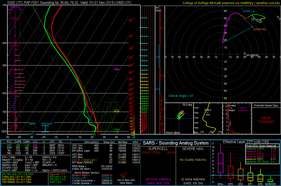 |
| 11/1 04z/12 AM EDT 925 mb T/Td/Wind | 10/31 21z/5 PM RAP Analysis Sounding from Mecklenburg County, VA | 11/1 4z/12 AM EDT RAP Analysis Sounding from KCPK (Chesapeake Regional Airport) |
 |
Media use of NWS Web News Stories is encouraged! Please acknowledge the NWS as the source of any news information accessed from this site. |
|


 Coastal Flood
 Heat
Heat