Overview
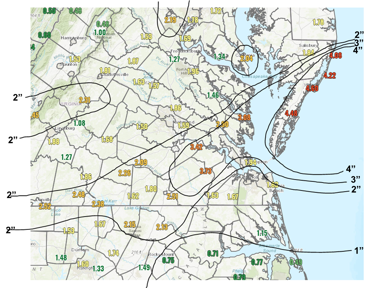
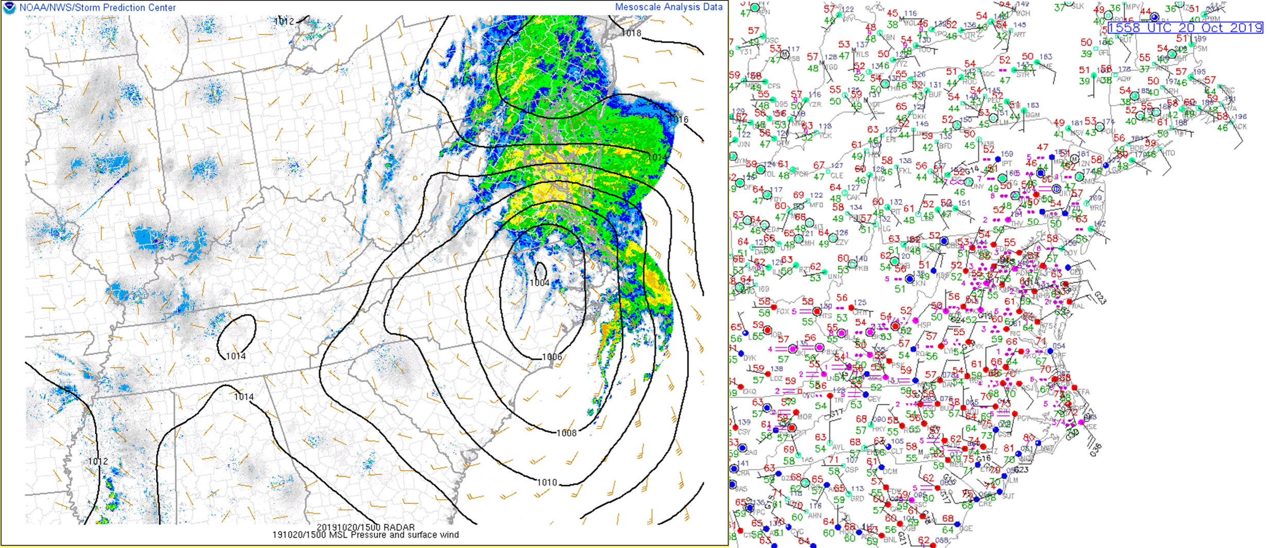
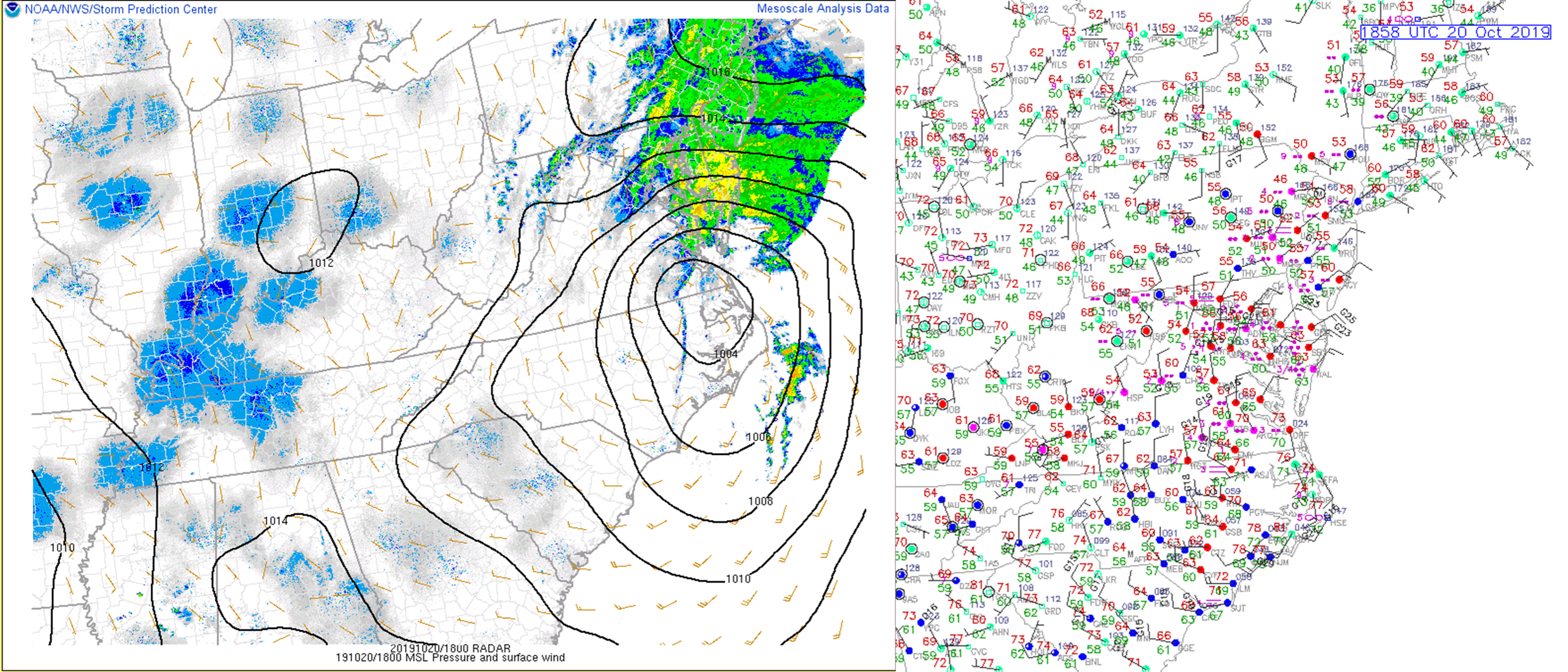
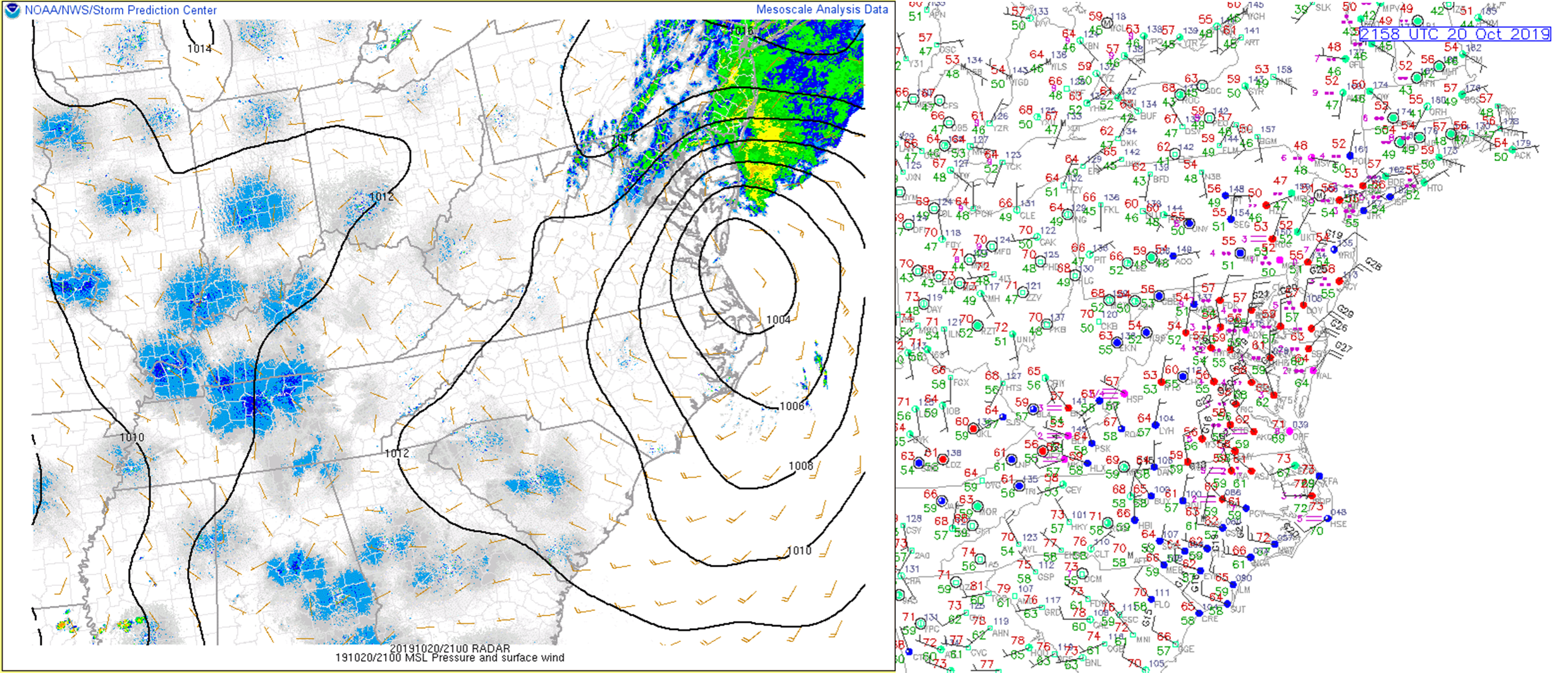
Tropical Storm Nestor made landfall in the Florida Panhandle during the late morning hours on Saturday, October 19th. Nestor became extratropical shortly after making landfall as it tracked to the northeast. Nestor continued to track to the northeast rather quickly, as its center moved into southeast North Carolina just before sunrise on 10/20. A large area of rain (mainly north/northeast of the center) overspread the Wakefield CWA from SW to NE during the morning hours on 10/20. 8 AM temperatures were in the mid-upper 50s across central VA, with upper 60s over far SE VA/NE NC. As the center of Nestor moved into NE NC by the late morning hours, temperatures jumped into the low-mid 70s across NE NC (as our NE NC counties were now in the warm sector after the steady rain moved to their north). Meanwhile, rain continued across much of Virginia and Maryland through the morning. Rainfall rates were generally in the 0.2 to 0.5 inch/hour range. However, there was one band of rain that moved across south-central/southeast VA during the morning hours that (briefly) produced rates of 1-1.5 inches/hour. This was associated with a band of frontogenesis that was most prominent in the 925-700 mb layer. The low center eventually tracked through SE VA (and onto southern portions of the VA Eastern Shore) during the afternoon hours on Sunday (10-21). As this happened, rain tapered off across the area from W to E. However, as the low moved over the Eastern Shore, some low-topped convection developed and moved across Accomack County, producing a quick 1.5" of rain from 2:30-4 PM (after 3" of rain was already reported). In total, rainfall amounts were 1-3" in most areas, with 3-5" from parts of SE VA to the Lower Eastern Shore. Luckily, only minor flooding was reported with this event (despite rainfall totals of 4-4.5" in some areas). This was due to the fact that antecedent conditions were quite dry (a large part of the area was in a moderate to locally severe drought), due to a short-term (1-2 month) deficit in rainfall.
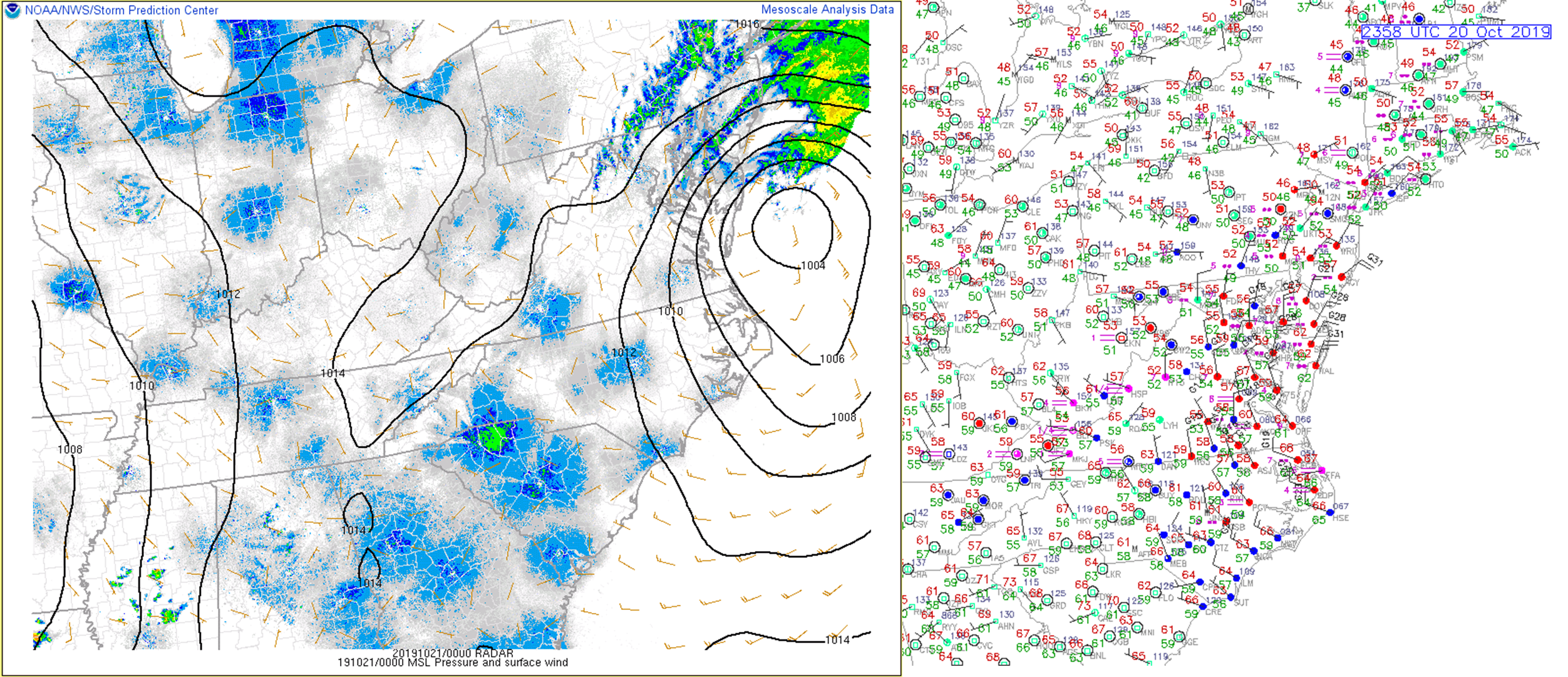
As the low pulled offshore during the late evening-overnight hours, north winds increased on the back side of the system...especially over the Chesapeake Bay/Atlantic Ocean. The combination of cold air advection (925 mb temperatures dropped into the 10-12°C range), strong 950-900 mb winds, and relatively warm water allowed for a 4-6 hour period of frequent wind gusts of 40-50 mph over the bay/ocean. Winds slowly subsided overnight as the low continued to move offshore (although wind restrictions were in place at the Chesapeake Bay Bridge Tunnel through 8-9 AM the next morning).
Storm Total Rainfall:
Radar
Header
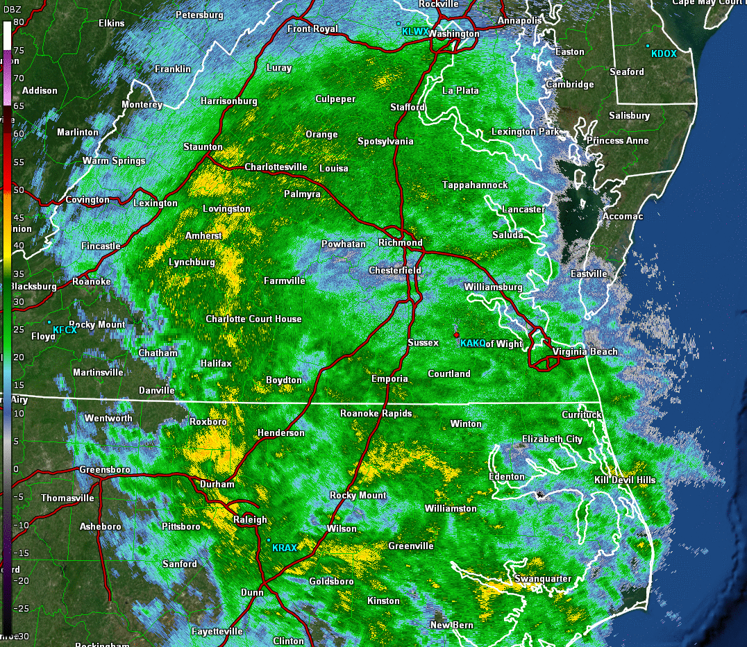 |
| Loop of 0.5° Base Reflectivity from ~5 AM-5 PM on 10/20 in ~30 minute increments |
Wind Reports
...HIGHEST WIND REPORTS...

Location                     Speed     Time/Date       Provider

...Maryland...

...Dorchester County...
Cambridge-Dorch              35 MPH    0300 PM 10/20   AWOS
Cambridge, MD                34 MPH    0254 PM 10/20   NOS-NWLON
Bucktown                     34 MPH    0255 PM 10/20   AWS
Blackwater                   33 MPH    0326 PM 10/20   RAWS
NEAVITT                      30 MPH    0332 PM 10/20   CWOP

...Somerset County...
Crisfield                    25 MPH    1000 PM 10/20   AWS

...Wicomico County...
Salisbury Wicomico Airport   39 MPH    0604 PM 10/20   ASOS

...Worcester County...
Assateague Island            43 MPH    0940 PM 10/20   RAWS
Ocean City                   43 MPH    0711 PM 10/20   ASOS
1 SSW Ocean City             41 MPH    0700 PM 10/20   AWS

...North Carolina...

...Camden County...
Shiloh                       36 MPH    0100 PM 10/20   CWOP

...Chowan County...
Edenton                      29 MPH    1155 AM 10/20   AWOS

...Currituck County...
Corolla                      43 MPH    1200 PM 10/20   CWOP
3.0 E Knotts Island (WEATHER 38 MPH    1250 PM 10/20   MESOWEST
1.6 NW Moyock (WEATHERSTEM)  37 MPH    1030 AM 10/20   MESOWEST
3.4 S Corolla (WEATHERSTEM)  36 MPH    1100 AM 10/20   MESOWEST
0.5 E Jarvisburg (WEATHERSTE 36 MPH    1240 PM 10/20   MESOWEST
Currituck                    35 MPH    1055 AM 10/20   AWOS

...Northampton County...
Conway                       37 MPH    1140 AM 10/20   CWOP

...Pasquotank County...
Elizabeth City               36 MPH    0113 PM 10/20   RAWS
Elizabeth City Airport       36 MPH    1031 AM 10/20   ASOS

...Perquimans County...
Chapanoke                    26 MPH    0125 PM 10/20   CWOP

...Virginia...

...Accomack County...
Tangier Sound Light          46 MPH    1004 PM 10/20   WXFLOW
Onancock                     44 MPH    0940 PM 10/20   WXFLOW
Wallops Island               37 MPH    0746 PM 10/20   ASOS
Wachapreague                 32 MPH    1218 PM 10/20   WXFLOW
Melfa Accomack               28 MPH    0955 PM 10/20   AWOS
Wachapreague, VA             28 MPH    1218 PM 10/20   NOS-NWLON
Parksley                     26 MPH    1001 PM 10/20   CWOP

...Brunswick County...
South Hill                   25 MPH    0435 PM 10/20   AWOS

...Caroline County...
Fort A.P Hill                25 MPH    0533 PM 10/20   RAWS

...City of Chesapeake County...
Fentress Naval               38 MPH    1146 AM 10/20   AWOS
Money Point                  32 MPH    1212 PM 10/20   NOS-PORTS
Chesapeake                   28 MPH    1015 AM 10/20   AWOS

...City of Colonial Heights County...
City Of Colonial Heights     25 MPH    0746 PM 10/20   CWOP

...City of Hampton County...
Langley AFB                  30 MPH    0928 PM 10/20   AWOS

...City of Newport News County...
Newport News                 30 MPH    0654 PM 10/20   ASOS

...City of Norfolk County...
Norfolk Intl Airport         39 MPH    1141 AM 10/20   ASOS
Norfolk NAS                  37 MPH    1247 PM 10/20   AWOS
Lafayette River              34 MPH    1110 AM 10/20   WXFLOW
Norfolk                      27 MPH    1246 PM 10/20   CWOP

...City of Poquoson County...
Poquoson                     35 MPH    1011 PM 10/20   WXFLOW

...City of Portsmouth County...
South Craney Island          33 MPH    1206 PM 10/20   NOS-PORTS
Portsmouth                   26 MPH    0153 PM 10/20   CWOP

...City of Suffolk County...
Suffolk                      28 MPH    0716 PM 10/20   CWOP

...City of Virginia Beach County...
Cape Henry                   51 MPH    0921 PM 10/20   WXFLOW
Oceana NAS Souce             40 MPH    1233 PM 10/20   AWOS
Back Bay                     33 MPH    1227 PM 10/20   RAWS
Virginia Beach               30 MPH    1010 PM 10/20   CWOP
Creeds                       29 MPH    1244 PM 10/20   WXFLOW

...Dinwiddie County...
Dinwiddie                    27 MPH    0423 PM 10/20   CWOP
Petersburg                   25 MPH    0615 PM 10/20   AWOS

...Essex County...
Dunnsville                   27 MPH    1048 AM 10/20   CWOP
Tappahannock                 25 MPH    0655 PM 10/20   AWOS

...Henrico County...
KRIC Richmond Intl Airport   31 MPH    0625 PM 10/20   ASOS

...King and Queen County...
West Point                   35 MPH    1235 PM 10/20   AWOS

...Louisa County...
Mineral                      27 MPH    1005 AM 10/20   CWOP

...Lunenburg County...
2 WSW Kenbridge              36 MPH    1005 AM 10/20   CWOP
Kenbridge                    25 MPH    0555 PM 10/20   AWOS

...Mathews County...
New Point Comfort            36 MPH    1135 AM 10/20   WXFLOW
North                        29 MPH    0748 PM 10/20   CWOP

...Mecklenburg County...
Boydton                      28 MPH    1147 AM 10/20   CWOP

...Middlesex County...
Saluda                       31 MPH    1015 PM 10/20   AWOS

...Northampton County...
Kiptopeke, VA                44 MPH    0848 PM 10/20   NOS-NWLON

...Northumberland County...
Lewisetta, VA                37 MPH    0112 PM 10/20   NOS-NWLON

...Nottoway County...
Blackstone Fort              26 MPH    0315 PM 10/20   AWOS

...York County...
Seaford                      26 MPH    1111 AM 10/20   CWOP
...Virginia...
Rappahannock Light           51 MPH    0906 PM 10/20   NOS-PORTS
Cape Henry, VA               49 MPH    0948 PM 10/20   NOS-PORTS
8 NW Cape Henry              47 MPH    0924 PM 10/20   NDBC
Plantation Flats             47 MPH    0943 PM 10/20   WXFLOW
Silver Beach                 45 MPH    0914 PM 10/20   WXFLOW
6 NW Cape Henry              43 MPH    0950 PM 10/20   NDBC
Willoughby Deguassing Statio 41 MPH    1254 PM 10/20   NOS-PORTS
Sandbridge                   41 MPH    0104 PM 10/20   WXFLOW
York River East Rear Range L 40 MPH    1136 AM 10/20   NOS-PORTS
5 NE Plum Tree Island Refuge 38 MPH    1130 AM 10/20   NDBC
Middle Ground Lighthouse     37 MPH    1251 PM 10/20   WXFLOW
Thimble Shoals               37 MPH    0959 PM 10/20   WXFLOW
2 E Stingray Point           36 MPH    0912 PM 10/20   NDBC
Hampton Flats                36 MPH    1202 PM 10/20   WXFLOW
Deltaville                   35 MPH    0957 PM 10/20   WXFLOW
Dominion Terminal            33 MPH    1006 AM 10/20   NOS-PORTS
Poquoson River Light         33 MPH    0957 PM 10/20   WXFLOW
Machipongo                   32 MPH    1052 AM 10/20   CWOP
Yorktown USCG Training Cente 31 MPH    0918 PM 10/20   NOS-NWLON
Rainfall Reports
Location                     Amount    Time/Date       Lat/Lon

...Maryland...

...Dorchester County...
Blackwater                   1.78 in   0526 PM 10/20   38.45N/76.09W
Cambridge                    1.63 in   0600 PM 10/20   38.58N/76.09W
NEAVITT                      1.32 in   0601 PM 10/20   38.40N/76.10W

...Somerset County...
Princess Anne                2.56 in   0604 PM 10/20   38.20N/75.69W
Crisfield                    1.69 in   0603 PM 10/20   37.98N/75.86W

...Wicomico County...
Powellville                  2.77 in   0548 PM 10/20   38.36N/75.43W
Salisbury Wicomico Airport   1.81 in   0602 PM 10/20   38.33N/75.50W

...Worcester County...
Assateague Island            4.00 in   0540 PM 10/20   38.08N/75.20W
Ocean City                   3.79 in   0553 PM 10/20   38.32N/75.12W
Berlin                       3.25 in   0555 PM 10/20   38.32N/75.12W

...North Carolina...

...Bertie County...
Windsor 8.8 NW               1.92 in   1140 AM 10/20   36.08N/77.06W
Aulander 0.6 NE              1.00 in   1201 PM 10/20   36.24N/77.11W

...Camden County...
South Mills                  0.87 in   0603 PM 10/20   36.45N/76.30W

...Currituck County...
Currituck                    0.92 in   0555 PM 10/20   36.40N/76.02W
Corolla                      0.74 in   0602 PM 10/20   36.30N/75.80W

...Northampton County...
Henrico                      2.31 in   0601 PM 10/20   36.54N/77.86W
Conway                       2.05 in   0600 PM 10/20   36.43N/77.23W

...Pasquotank County...
Elizabeth City               1.31 in   0603 PM 10/20   36.30N/76.27W
Elizabeth City Airport       1.14 in   0600 PM 10/20   36.27N/76.18W

...Perquimans County...
Hertford                     1.09 in   0603 PM 10/20   36.17N/76.30W

...Virginia...

...Accomack County...
Wallops Island               4.47 in   0554 PM 10/20   37.93N/75.47W
Parksley                     4.43 in   0602 PM 10/20   37.73N/75.61W
Melfa Accomack               3.90 in   0555 PM 10/20   37.63N/75.77W
Chincoteague                 3.33 in   0603 PM 10/20   37.93N/75.38W

...Amelia County...
Jetersville 3.6 W            1.84 in   0800 AM 10/20   37.30N/78.16W
Amelia Courthouse            1.65 in   0605 PM 10/20   37.34N/77.98W

...Brunswick County...
Lawrenceville                1.80 in   0555 PM 10/20   36.78N/77.80W
South Hill Meckl             1.62 in   0555 PM 10/20   36.68N/78.03W

...Caroline County...
Faph_north1                  2.14 in   0526 PM 10/20   38.19N/77.30W
Faph_eodtc                   1.93 in   0532 PM 10/20   38.13N/77.18W
Bowling Green                1.59 in   0604 PM 10/20   38.04N/77.34W

...Chesterfield County...
Matoaca                      2.16 in   0601 PM 10/20   37.29N/77.48W
Midlothian                   1.96 in   0605 PM 10/20   37.55N/77.66W
Bon Air                      1.82 in   0604 PM 10/20   37.53N/77.56W
Winterpock                   1.56 in   0555 PM 10/20   37.34N/77.64W
5 NNE Winterpock             1.30 in   0604 PM 10/20   37.41N/77.68W

...City of Chesapeake County...
7.4 NW Horseshoe             4.00 in   0500 PM 10/20   36.56N/76.44W
Fentress Naval               1.24 in   0556 PM 10/20   36.70N/76.13W

...City of Colonial Heights County...
City Of Colonial Heights     2.16 in   0600 PM 10/20   37.25N/77.41W

...City of Hampton County...
Langley AFB Hamp             1.92 in   0538 PM 10/20   37.07N/76.37W
Hampton                      1.78 in   0602 PM 10/20   37.09N/76.42W

...City of Hopewell County...
1 NE Hopewell                2.55 in   0605 PM 10/20   37.30N/77.29W

...City of Newport News County...
Newport News                 2.38 in   0554 PM 10/20   37.13N/76.50W

...City of Norfolk County...
Norfolk Intl Airport         1.83 in   0551 PM 10/20   36.90N/76.20W
Norfolk NAS Cham             1.71 in   0559 PM 10/20   36.92N/76.27W

...City of Portsmouth County...
Portsmouth                   1.55 in   0603 PM 10/20   36.80N/76.33W

...City of Richmond County...
2.5 W East Highland Park (IF 1.69 in   0123 PM 10/20   37.56N/77.42W

...City of Suffolk County...
Gdr                          1.71 in   0526 PM 10/20   36.61N/76.55W
Suffolk                      1.66 in   0600 PM 10/20   36.87N/76.50W

...City of Virginia Beach County...
Virginia Beach               1.78 in   0601 PM 10/20   36.82N/76.20W
Oceana NAS Souce             1.59 in   0556 PM 10/20   36.82N/76.02W
North Port                   1.59 in   0600 PM 10/20   36.84N/75.99W
Back Bay                     1.57 in   0527 PM 10/20   36.67N/75.92W

...City of Williamsburg County...
Williamsburg                 2.01 in   0605 PM 10/20   37.28N/76.71W

...Cumberland County...
Farmville                    1.68 in   0555 PM 10/20   37.35N/78.42W
1.2 E Reeds                  1.60 in   1000 AM 10/20   37.33N/78.38W
Farmville                    1.60 in   0602 PM 10/20   37.42N/78.35W

...Dinwiddie County...
Dinwiddie                    2.79 in   0603 PM 10/20   36.98N/77.54W
Churchroad                   2.56 in   0601 PM 10/20   37.13N/77.69W

...Essex County...
Dunnsville                   1.75 in   0603 PM 10/20   37.89N/76.81W
Tappahannock                 1.46 in   0555 PM 10/20   37.87N/76.90W

...Fluvanna County...
Scottsville                  1.32 in   0600 PM 10/20   37.74N/78.40W
1 S Union Mills              1.32 in   0604 PM 10/20   37.92N/78.31W

...Gloucester County...
Hayes                        2.32 in   0605 PM 10/20   37.27N/76.43W

...Goochland County...
Kents Store                  1.64 in   0602 PM 10/20   37.87N/78.05W

...Greensville County...
Purdy                        3.07 in   0604 PM 10/20   36.80N/77.60W
Emporia                      2.24 in   0555 PM 10/20   36.68N/77.48W

...Hanover County...
Richmond Hanover             1.85 in   0554 PM 10/20   37.70N/77.43W
Ashland                      1.67 in   0600 PM 10/20   37.75N/77.48W
Montpelier                   1.50 in   0600 PM 10/20   37.81N/77.64W

...Henrico County...
Richmond                     1.67 in   0605 PM 10/20   37.60N/77.58W
Glen Allen                   1.66 in   0605 PM 10/20   37.69N/77.59W
Richmond Intl Airport        1.59 in   0554 PM 10/20   37.52N/77.32W
2 WNW Tuckahoe               1.47 in   0604 PM 10/20   37.60N/77.63W
1 NW Lakeside                1.46 in   0605 PM 10/20   37.63N/77.48W

...Isle of Wight County...
Smithfield                   1.76 in   0603 PM 10/20   36.99N/76.74W
Carrollton                   1.67 in   0558 PM 10/20   36.93N/76.53W
Franklin J B Ros             1.63 in   0555 PM 10/20   36.70N/76.90W

...James City County...
Fords Colony                 3.89 in   0358 PM 10/20   37.30N/76.75W
Williamsburg 2.1 WNW         1.44 in   1007 AM 10/20   37.28N/76.74W

...King William County...
West Point                   3.08 in   0600 PM 10/20   37.57N/76.80W

...King and Queen County...
West Point                   2.89 in   0555 PM 10/20   37.52N/76.77W

...Lancaster County...
Kilmarnock                   3.16 in   0604 PM 10/20   37.71N/76.38W
Mollusk                      2.83 in   0601 PM 10/20   37.71N/76.53W
Lancaster                    2.71 in   0601 PM 10/20   37.73N/76.51W

...Louisa County...
Troy                         2.27 in   0602 PM 10/20   38.01N/78.25W
Louisa                       1.96 in   0552 PM 10/20   38.04N/78.01W
Mineral                      1.93 in   0605 PM 10/20   38.02N/77.92W
Troy                         1.64 in   0600 PM 10/20   38.00N/78.24W
Bumpass                      1.56 in   0555 PM 10/20   37.97N/77.75W
Louisa                       1.55 in   0555 PM 10/20   38.02N/77.97W

...Lunenburg County...
Kenbridge                    2.26 in   0555 PM 10/20   36.95N/78.18W
2 WSW Kenbridge              2.11 in   0601 PM 10/20   36.95N/78.17W
Victoria 0.9 N               1.47 in   0700 AM 10/20   37.01N/78.22W

...Mathews County...
1 NNW Mathews                2.33 in   0605 PM 10/20   37.45N/76.33W
North                        2.24 in   0603 PM 10/20   37.45N/76.45W

...Mecklenburg County...
John H Kerr Dam              3.10 in   0345 PM 10/20   36.60N/78.30W
Chase City                   2.67 in   0555 PM 10/20   36.78N/78.50W
Boydton                      2.38 in   0602 PM 10/20   36.73N/78.36W
Clarksville                  1.63 in   0700 AM 10/20   36.62N/78.57W

...Middlesex County...
Hartfield                    4.16 in   0601 PM 10/20   37.56N/76.51W
Remlik                       3.55 in   0555 PM 10/20   37.68N/76.62W
Saluda                       3.08 in   0555 PM 10/20   37.60N/76.45W

...Northampton County...
Oyster                       2.28 in   0200 PM 10/20   37.29N/75.93W
Willis Wharf                 2.01 in   0605 PM 10/20   37.52N/75.82W

...Northumberland County...
Kilmarnock                   2.62 in   0600 PM 10/20   37.70N/76.31W

...Nottoway County...
Crewe                        2.71 in   0602 PM 10/20   37.18N/78.13W
Blackstone Fort              0.94 in   0555 PM 10/20   37.07N/77.95W

...Powhatan County...
Powhatan                     1.50 in   0602 PM 10/20   37.50N/77.93W

...Prince Edward County...
Pamplin                      1.80 in   0600 PM 10/20   37.27N/78.63W
Farmville                    1.30 in   0605 PM 10/20   37.30N/78.39W

...Prince George County...
2 WSW Garysville             1.78 in   0605 PM 10/20   37.23N/77.20W

...Richmond County...
1 NNE Kennard                2.78 in   0604 PM 10/20   37.94N/76.74W

...Southampton County...
Drewryville 2.3 SW           2.32 in   0935 AM 10/20   36.69N/77.34W
2 WSW Courtland              1.65 in   0603 PM 10/20   36.70N/77.10W

...Surry County...
Surry                        2.94 in   0603 PM 10/20   37.17N/76.81W

...Sussex County...
Wakefield NWS                3.73 in   0354 PM 10/20   36.98N/77.00W

...York County...
Williamsburg                 3.85 in   0601 PM 10/20   37.35N/76.70W
Seaford                      2.57 in   0551 PM 10/20   37.19N/76.43W
1 NNE Hornsbyville           2.02 in   0604 PM 10/20   37.22N/76.46W
Environment
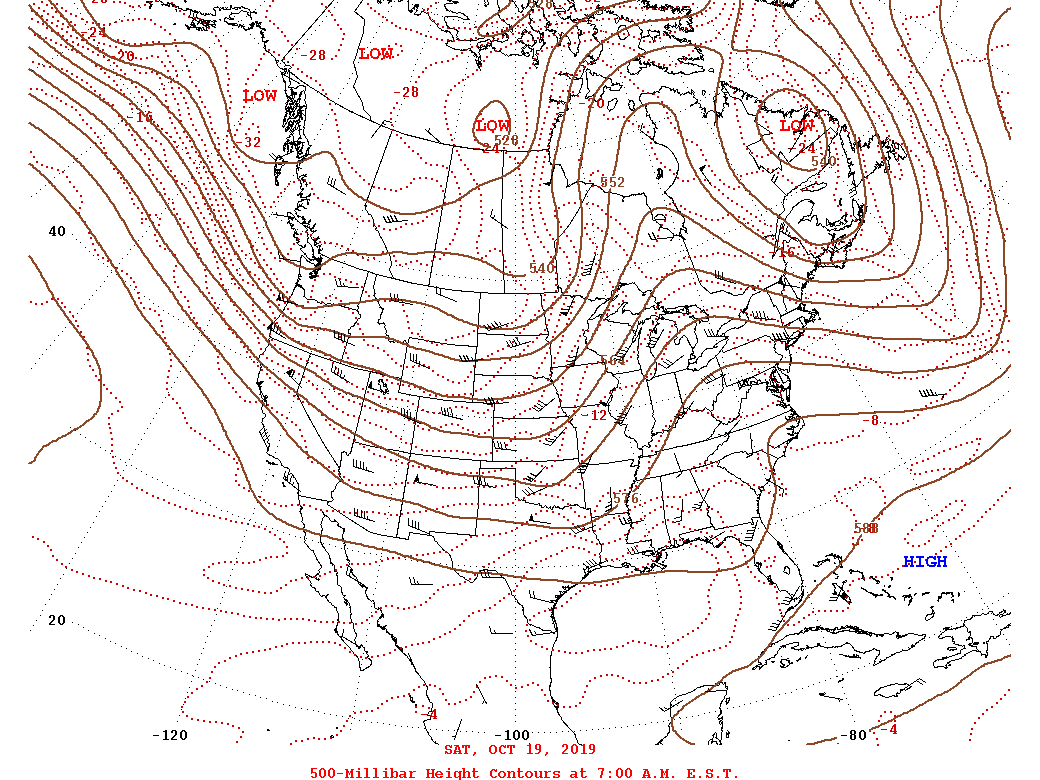
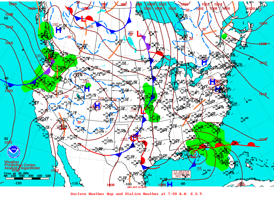
Synoptic Summary.
 |
 |
 |
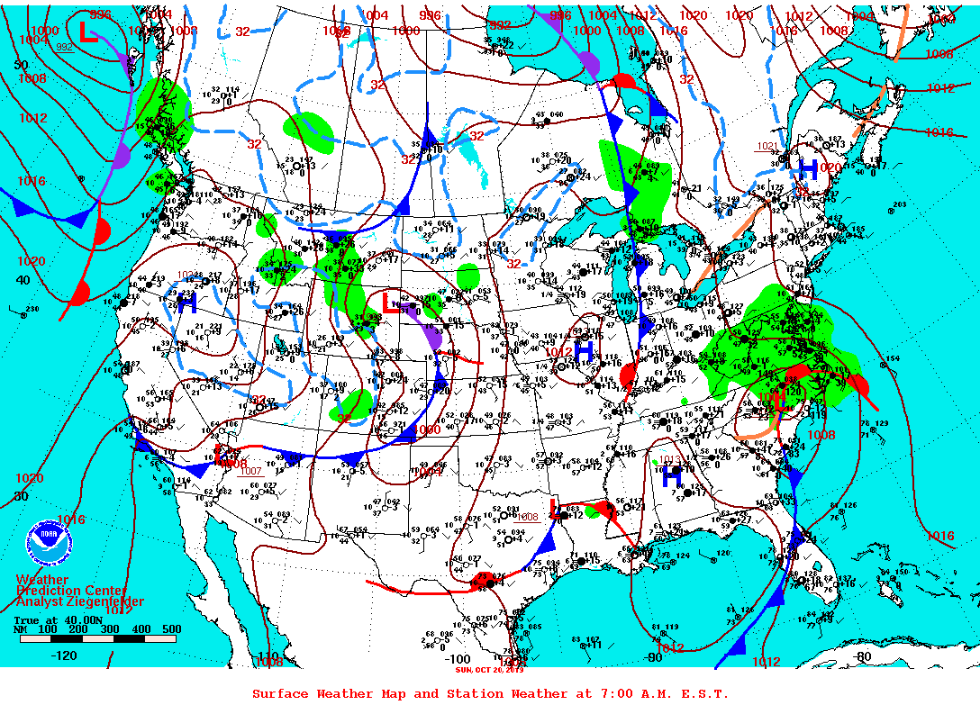 |
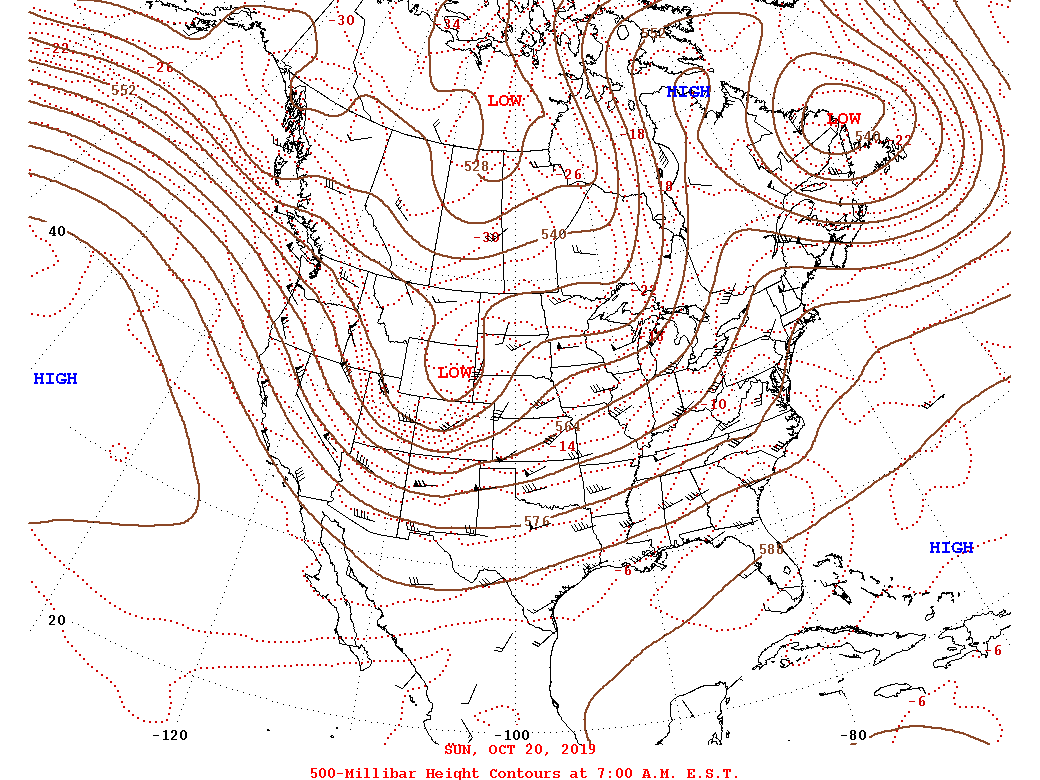
| 12z/8 AM 10-19 500 mb Analysis | 12z/8 AM 10-19 WPC Surface Analysis | 12z/8 AM 10-20 500 mb Analysis | 12z/8 AM 10-20 WPC Surface Analysis |
Regional Surface Analysis.
 |
 |
 |
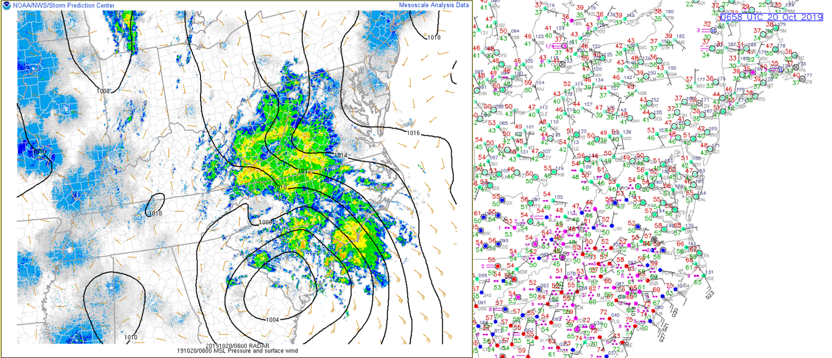
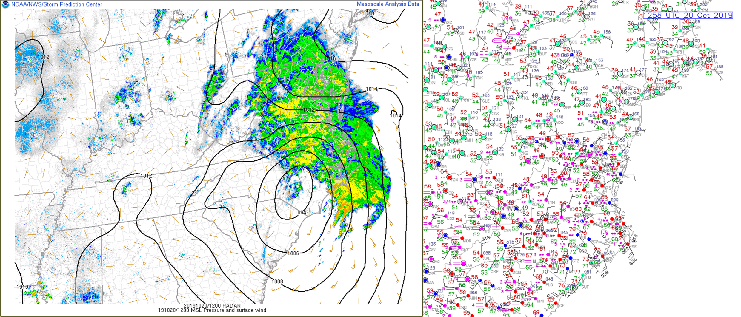
| 06z/2 AM 10-20 Surface Analysis + Observations | 12z/8 AM 10-20 Surface Analysis + Observations | 15z/11 AM 10-20 Surface Analysis + Observations |
 |
 |
 |
| 18z/2 PM 10-20 Surface Analysis + Observations | 21z/5 PM 10-20 Surface Analysis + Observations | 00z 10-21 /8 PM 10-20 Surface Analysis + Observations |
Additional Environmental Data.
 |
 |
 |
 |
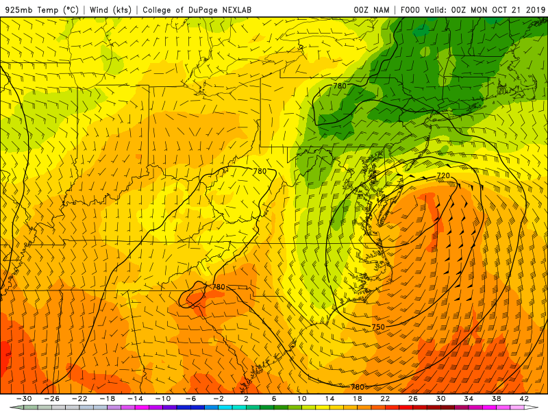
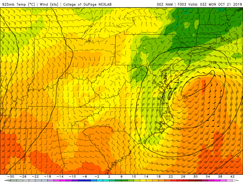
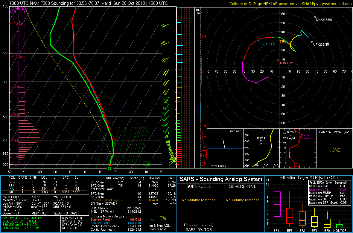
| 00z 10-21/8 PM 10-20 925 mb NAM Analysis | 03z 10-21/11 PM 10-20 NAM 925 mb Heights/Winds (3-h forecast) | 18z/2 PM 10-20 NAM Analysis Sounding from Cambridge, MD (Note the high PW values/large warm cloud depth despite surface temperatures of ~60F) | 18z/2 PM 10-20 NAM Analysis Sounding from KMFV (Melfa, VA). Note the PW Value of 2.3 inches, which is > 2 standard deviations above average for mid-late October. |
 |
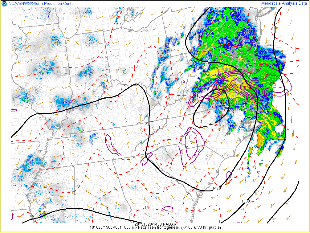 |
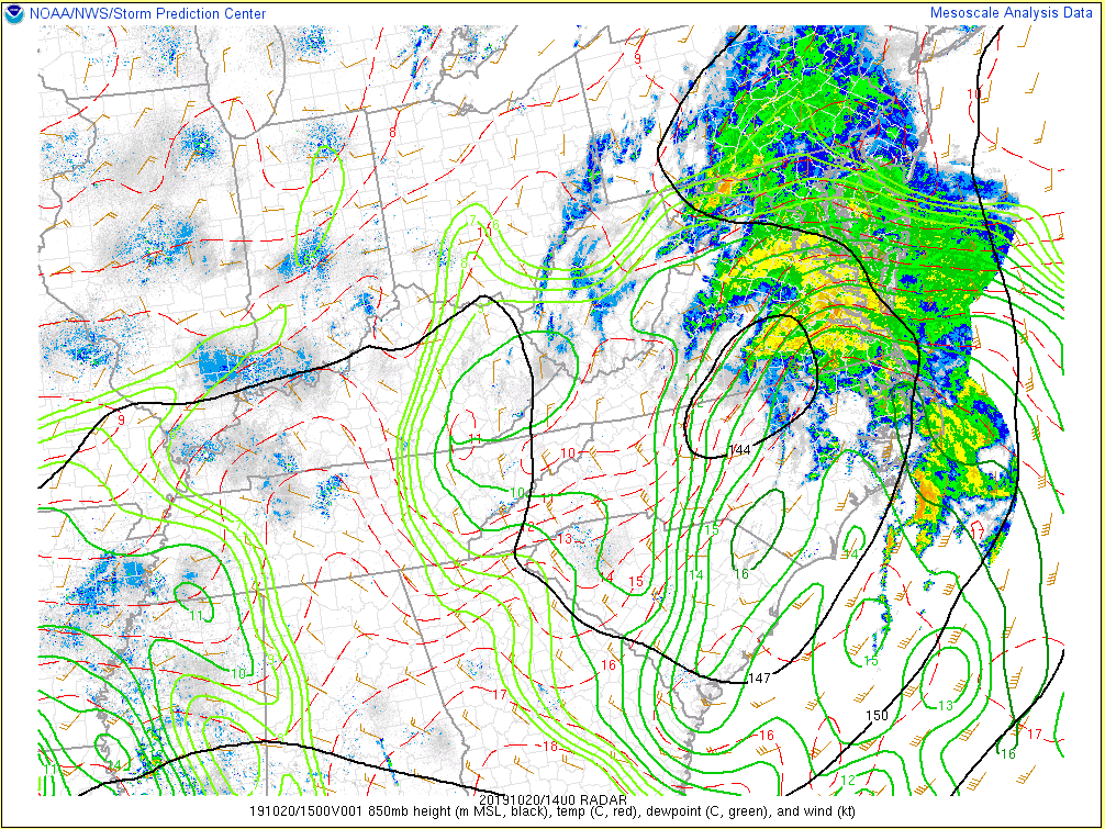
| 14z/10 AM 10-20 850 mb Analysis | 14z/10 AM 10-20 850 mb Frontogenesis |
 |
Media use of NWS Web News Stories is encouraged! Please acknowledge the NWS as the source of any news information accessed from this site. |
|


 Coastal Flood
 Heat
Heat