Overview
Hurricane Dorian made landfall in the Bahamas as a Category 5 Hurricane during Labor Day weekend. It slowly moved west toward Florida and weakened to a high-end Category 2. As it got to within 100 miles of the central Florida coast on Tuesday, Dorian turned northward and tracked just off the coasts of Florida, Georgia, then South Carolina from late Tuesday through Thursday afternoon (and briefly re-strengthened to a Category 3 before dropping to a Cat 2 by Thu evening). As Dorian moved northward, its wind field began to expand and tropical storm force wind gusts were observed very far from the center of the storm. During the afternoon and evening hours on Thursday, Dorian started to move northeast and missed making landfall in Cape Fear, NC by about 20 miles. Dorian continued to track just offshore of the coast of SE NC Thursday night through 7 AM Friday. Dorian’s only CONUS landfall came as the eye passed over Cape Hatteras just after 8 AM Friday morning. Dorian got picked up by a shortwave trough to the north and accelerated to the ENE during the day on Friday and was hundreds of miles offshore of the VA coast by early Saturday morning.
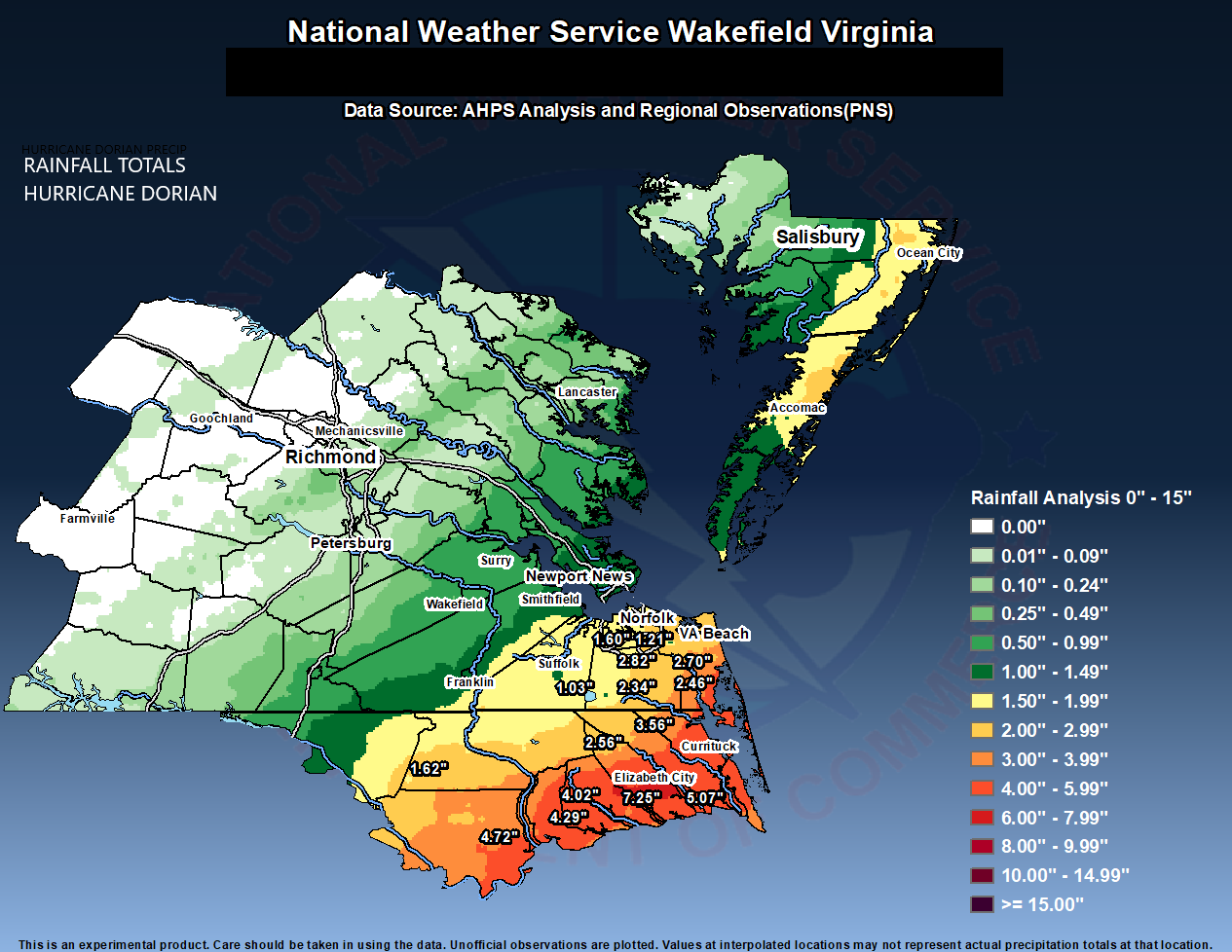
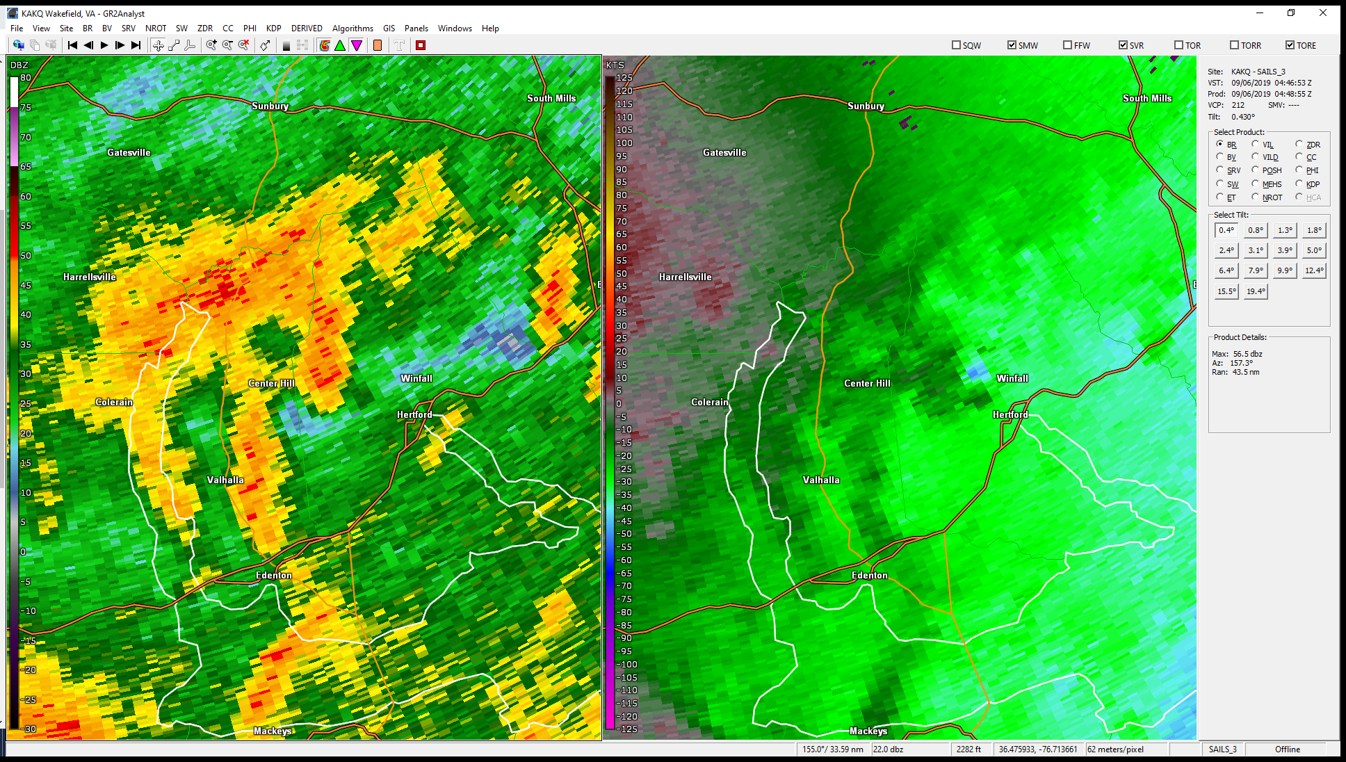
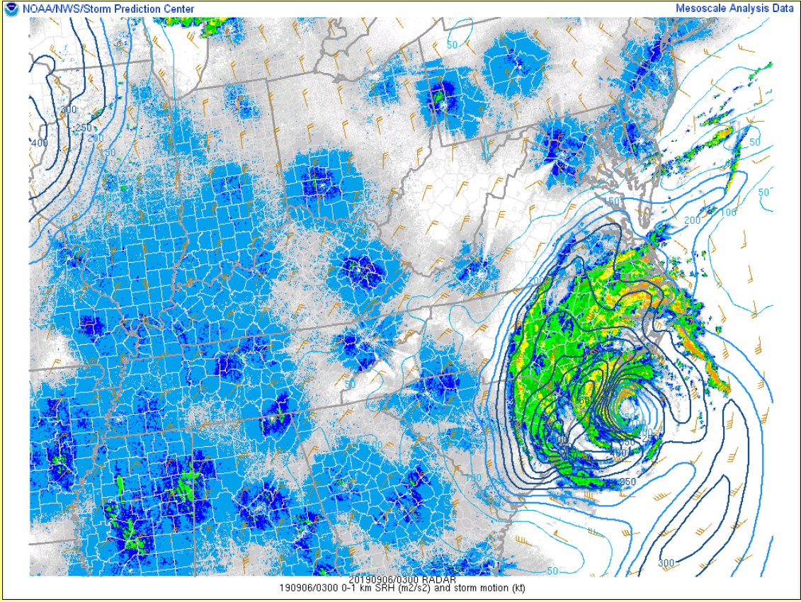
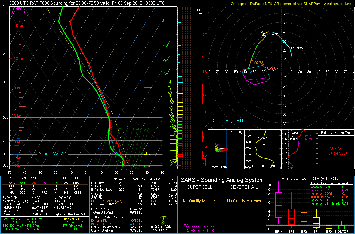
Not much in the way of rain was observed over the Wakefield CWA on Thursday, but there was a noticeable uptick in ENE-NE winds during the day/evening. Dorian’s outer rain bands started to move into areas of northeast NC just north/northwest of the Albemarle Sound by 10 PM Thursday. Rainfall rates briefly exceeded 2”/hour at times Thursday night. In addition, a few mini supercells developed between 11 PM Thursday-early Fri AM over the NE NC part of the AKQ CWA. This was to be expected, as NE NC was in the favorable northeast quadrant of Dorian with weak instability and enough low-level directional shear for a few rotating mini-supercells. Mesoanalysis indicated 0-1 km SRH values of 200-300 m2/s2. See the Environment section for more information and for a RAP analysis sounding taken around the time of the three tornado warnings in NE NC. Winds continued to increase out of the ENE-NE over the Wakefield CWA overnight, and tropical storm force winds were observed from Hampton Roads to NE NC by morning. In addition, torrential rain fell over parts of NE NC (In the AKQ CWA...mainly from southern Bertie County east-northeastward to Currituck County). This prompted Flash Flood Warnings to be issued. A steady, moderate to heavy rain moved into SE VA shortly before sunrise.
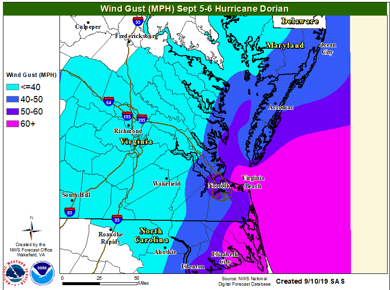
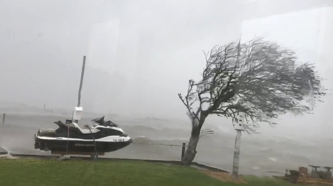
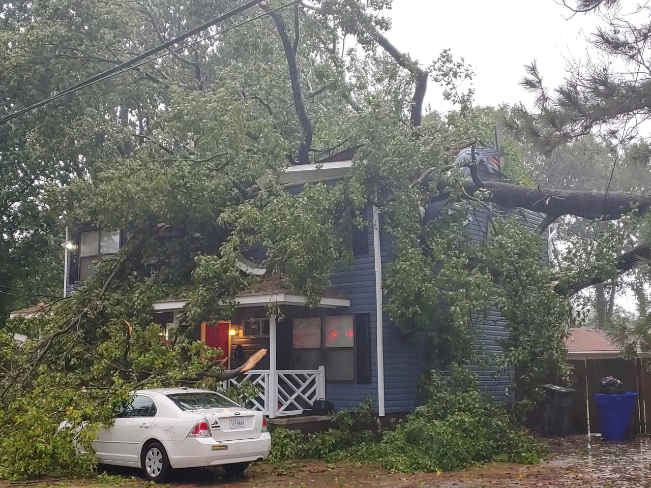
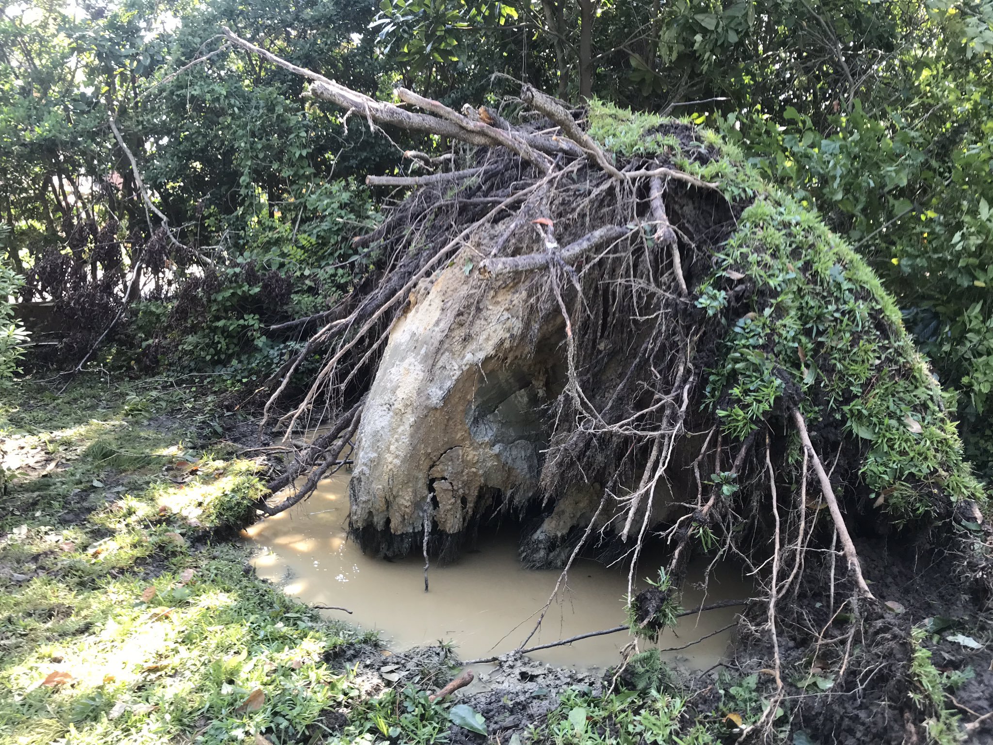
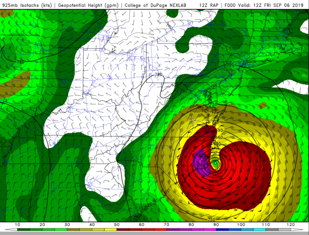
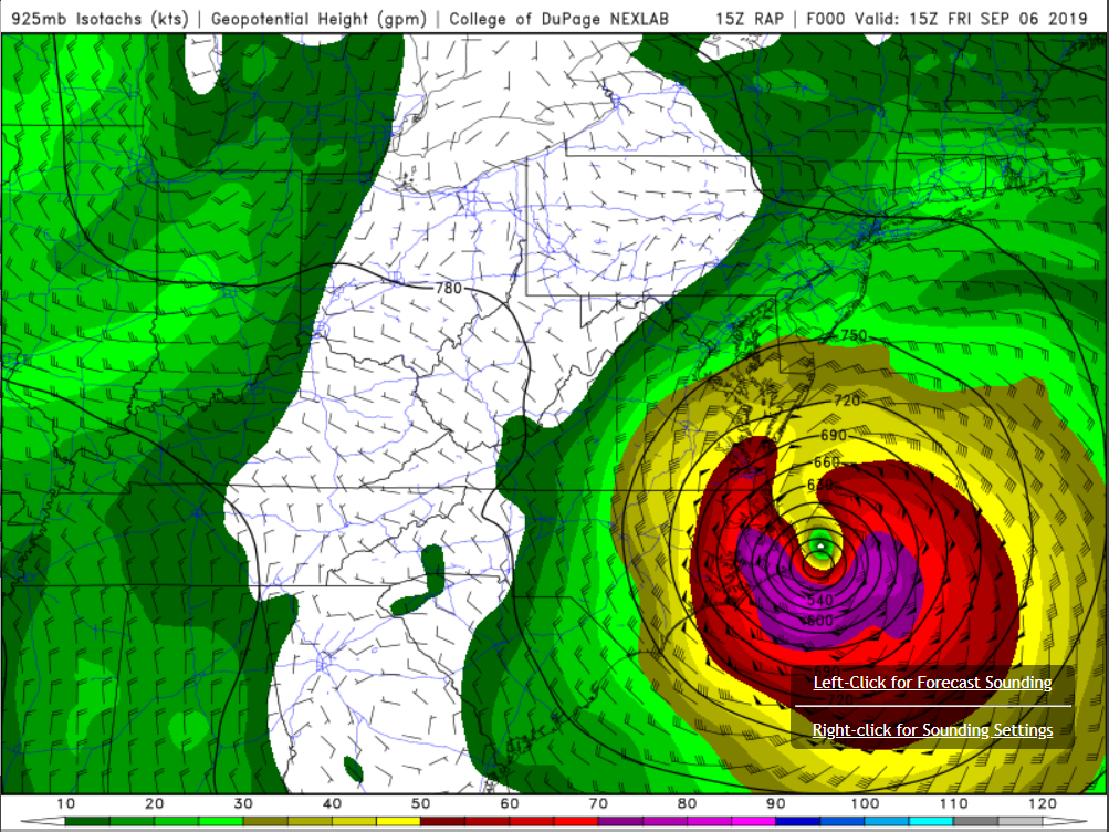
As Dorian moved toward Cape Hatteras (and eventually offshore) during the day on Friday, winds turned to the north and increased on the back side of the system, as slightly cooler air caused higher winds around the 925 mb level to mix down to the surface (mainly across Hampton Roads, NE NC, and the marine areas). 925 mb winds on the back side of the system ranged from 50-75 knots, and peak gusts at Norfolk/Elizabeth City were in the 64 and 70 mph range (this occurred during the mid-late morning hours on 9/6. These wind gusts uprooted numerous trees and caused some minor structural damage. Unfortunately, there were reports of a few trees that fell on houses (in Norfolk, Chesapeake, and VA Beach). Over the marine zones, hurricane-force wind gusts were observed at Chesapeake Light Tower and Duck Pier, with near hurricane-force gusts over the Lower Chesapeake Bay. Additionally, moderate to heavy rain continued through the early afternoon over Hampton Roads/NE NC (with the steady rain moving over the Lower Eastern Shore as well). The rain continued in these areas through early-mid afternoon (even through they were well NW of Dorian's center) due to (in part) the development of mid-level frontogenetical forcing as Dorian interacted with the aforementioned shortwave trough. Rain totals were 1"-3" from Ocean City to Hampton Roads, with totals of 3"-5" in coastal sections of VA Beach. A few amounts in excess of 7" were observed across NE NC. However, since the area had not received significant rainfall in the week preceding the arrival of Dorian, no Flash Flood Emergencies had to be issued.
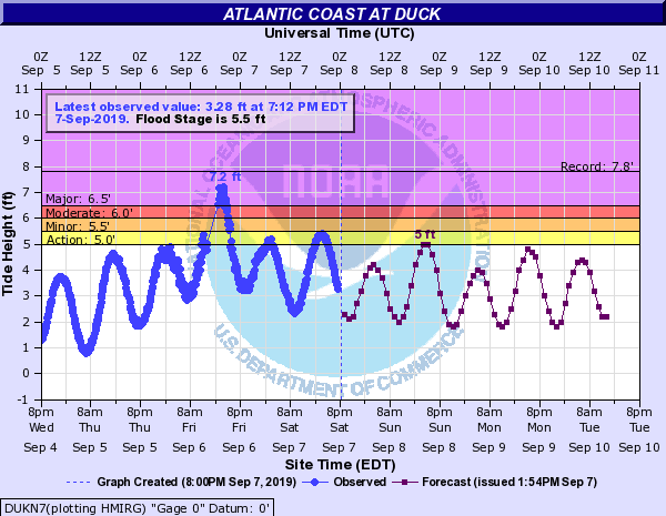
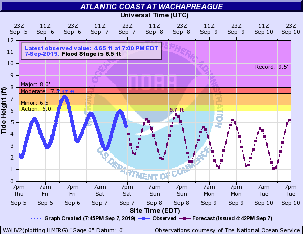
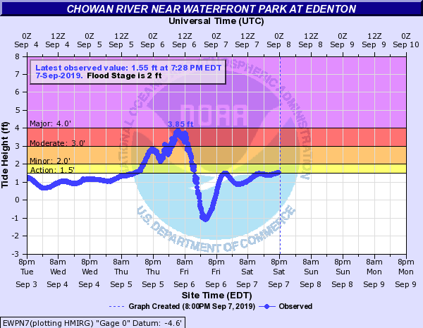
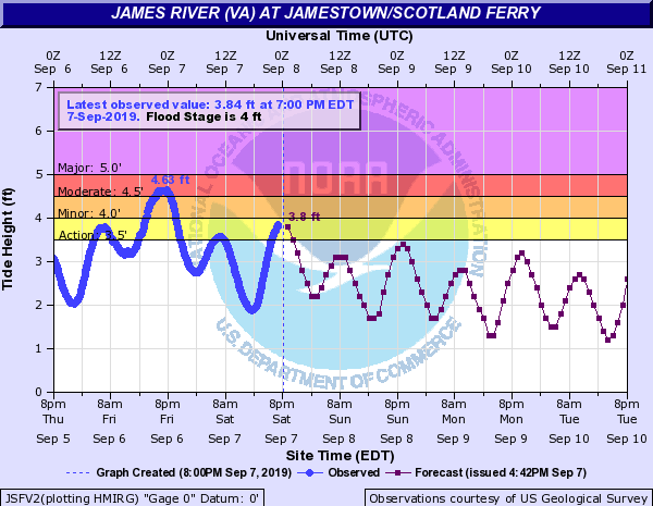
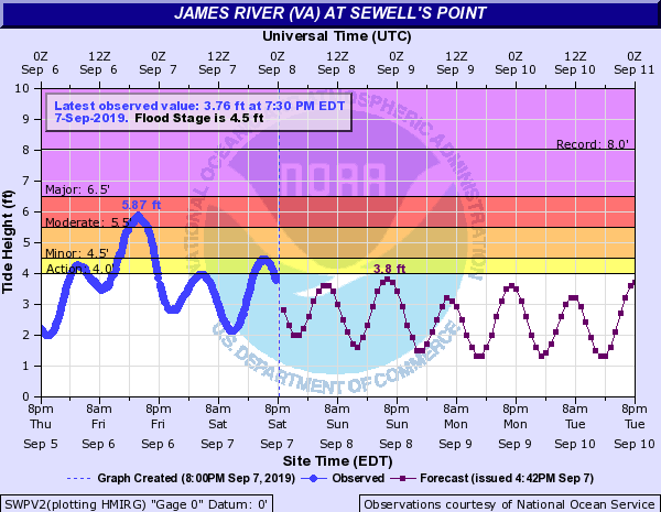
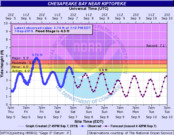
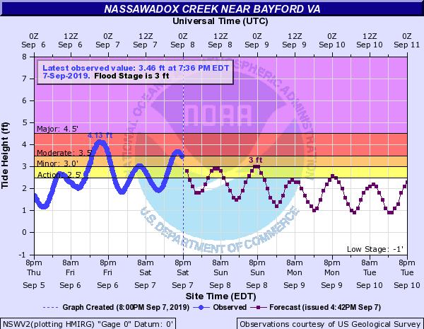
Lastly, Dorian caused moderate to major tidal flooding across SE VA/NE NC (with minor flooding on the ocean side of the Lower Eastern Shore). The tide gauge at Edenton, NC nearly exceeded major flood thresholds by sunrise Friday as tropical storm force ENE-NE winds pushed water into the Albemarle Sound. Areas adjacent to the Lower Chesapeake Bay/Lower James River saw water levels peak during high tide Friday afternoon (after the rain had largely ended) as winds became more northerly. The three gauges in/very close to the AKQ CWA where water levels exceeded major flood thresholds were Kiptopeke (VA), the Chesapeake Bay Bridge Tunnel, and Duck (NC). See the Tidal Flooding section for Hydrographs of several of the tide gauges.
***Data is preliminary and subject to change***
| RAINFALL ANALYSIS DORIAN | WIND ANALYSIS DORIAN |
 |
 |
Tornadoes:
|
Tornado - 3 SW Parkville
Track Maps 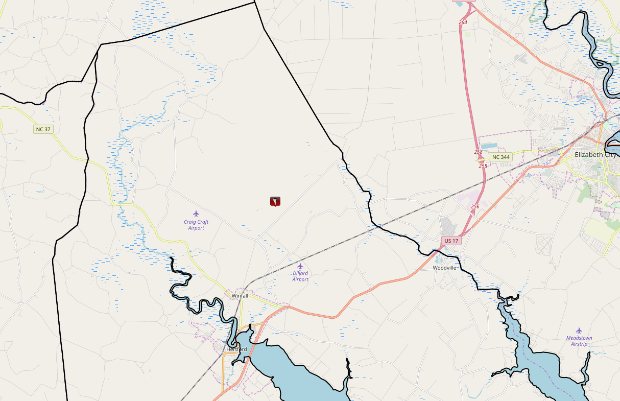 
|
||||||||||||||||
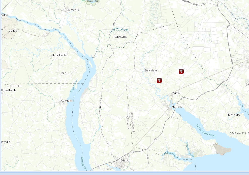
Tornado - Near Belvidere Rd
|
||||||||||||||||
The Enhanced Fujita (EF) Scale classifies tornadoes into the following categories:
| EF0 Weak 65-85 mph |
EF1 Moderate 86-110 mph |
EF2 Significant 111-135 mph |
EF3 Severe 136-165 mph |
EF4 Extreme 166-200 mph |
EF5 Catastrophic 200+ mph |
 |
|||||
Wind Reports/Photos
Public Information Statement
National Weather Service Wakefield VA
431 PM EDT Fri Sep 6 2019

...HIGHEST WIND REPORTS...

Location                     Speed     Time/Date       Lat/Lon
Chesapeake Light Tower       83 MPH    1011 AM 09/06   36.90N/75.71W
Cape Henry                   70 MPH    1036 AM 09/06   36.93N/76.01W
Cape Henry, VA               70 MPH    1054 AM 09/06   36.93N/76.01W
Elizabeth City Airport       70 MPH    0744 AM 09/06   36.27N/76.18W
Ccem Carova Beach Fire Depar 68 MPH    0750 AM 09/06   36.52N/75.87W
Third Island                 68 MPH    1034 AM 09/06   37.04N/76.08W
2 NNE Bayside                68 MPH    0746 AM 09/06   36.91N/76.12W
Norfolk Intl Airport         64 MPH    1116 AM 09/06   36.90N/76.20W
Rudee Inlet                  64 MPH    0907 AM 09/06   36.83N/75.97W
Sandbridge                   64 MPH    0959 AM 09/06   36.70N/75.93W
Corolla                      63 MPH    1030 AM 09/06   36.30N/75.80W
3 NW Moyock                  61 MPH    0939 AM 09/06   36.52N/76.18W
Middle Ground Lighthouse     60 MPH    0851 AM 09/06   36.95N/76.39W
Creeds                       59 MPH    0805 AM 09/06   36.59N/76.02W
Edenton                      59 MPH    0820 AM 09/06   36.02N/76.57W
Hertford                     56 MPH    0745 AM 09/06   36.16N/76.32W
Willoughby Deguassing Statio 56 MPH    0848 AM 09/06   36.98N/76.32W
Fentress Naval               55 MPH    0934 AM 09/06   36.70N/76.13W
Chapanoke                    54 MPH    0640 AM 09/06   36.24N/76.36W
Hampton Flats                54 MPH    0847 AM 09/06   36.98N/76.36W
Oceana NAS Souce             54 MPH    1124 AM 09/06   36.82N/76.02W
South Craney Island          53 MPH    0800 AM 09/06   36.89N/76.34W
New Point Comfort            53 MPH    0940 AM 09/06   37.33N/76.27W
1 NW Cradock                 52 MPH    1145 AM 09/06   36.80N/76.33W
Poquoson                     52 MPH    1116 AM 09/06   37.11N/76.32W
Thimble Shoals               52 MPH    1149 AM 09/06   37.05N/76.26W
York River East Rear Range L 52 MPH    1130 AM 09/06   37.25N/76.33W
Rappahannock Light           51 MPH    1154 AM 09/06   37.54N/76.02W
Suffolk                      50 MPH    0901 AM 09/06   36.87N/76.50W
Lafayette River              49 MPH    1015 AM 09/06   36.89N/76.32W
Norfolk NAS Cham             49 MPH    0841 AM 09/06   36.92N/76.27W
Tangier Sound Light          49 MPH    1216 PM 09/06   37.79N/75.97W
Wachapreague, VA             49 MPH    1148 AM 09/06   37.61N/75.69W
Hampton                      48 MPH    0824 AM 09/06   37.08N/76.30W
Kiptopeke, VA                48 MPH    1142 AM 09/06   37.17N/75.99W
Poquoson River Light         47 MPH    0543 AM 09/06   37.16N/76.38W
Plantation Flats             47 MPH    0749 AM 09/06   37.26N/76.03W
Deltaville                   46 MPH    0922 AM 09/06   37.56N/76.31W
Ocean City                   46 MPH    1119 AM 09/06   38.33N/75.08W
Chesapeake                   45 MPH    0815 AM 09/06   36.67N/76.32W
Wallops Island               45 MPH    1209 PM 09/06   37.93N/75.47W
Greens Cross                 44 MPH    0817 AM 09/06   36.02N/76.89W
Langley AFB Hamp             44 MPH    0933 AM 09/06   37.07N/76.37W
Machipongo                   44 MPH    0755 AM 09/06   37.41N/75.97W
Assateague Island            43 MPH    1140 AM 09/06   38.08N/75.20W
Tangier Island               43 MPH    1101 AM 09/06   37.82N/75.98W
2 WSW Kenbridge              38 MPH    0521 PM 09/05   36.95N/78.17W
Ahoskie Tri Coun             36 MPH    0935 AM 09/06   36.28N/77.17W
Lewisetta, VA                36 MPH    1142 AM 09/06   38.00N/76.46W
Emporia                      35 MPH    0835 AM 09/06   36.68N/77.48W
Toano                        29 MPH    1150 AM 09/06   37.44N/76.82W
&&
Selected Wind/Wind Damage Photos
 |
 |
 |
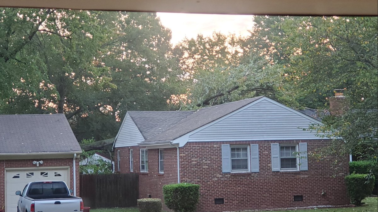 |
| Currituck Sound from Waterlilly, NC (Credit: WAVY-TV) | Tree Down on House in Norfolk (Credit: WAVY-TV) | Large Tree Uprooted in Elizabeth City (Credit: 13 News Now) | Tree Down on House in VA Beach (Credit: Jeffrey Adams) |
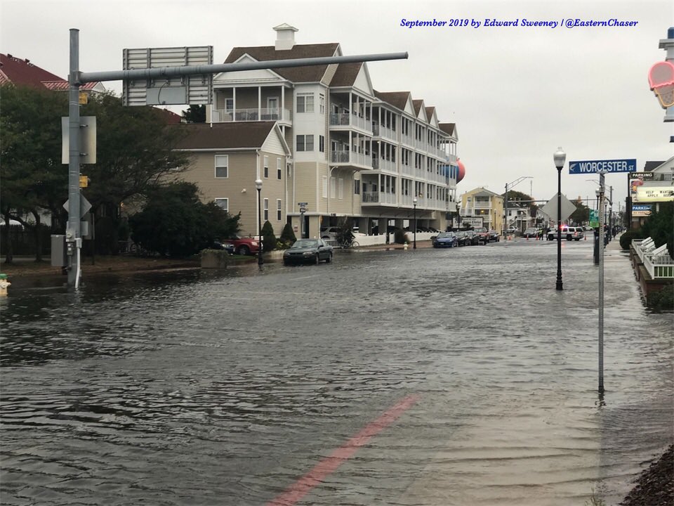
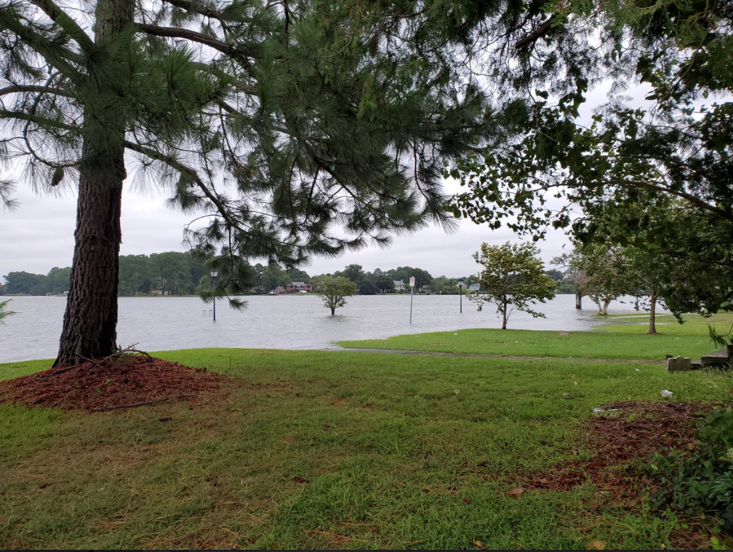
Selected Flooding Photos
 |
 |
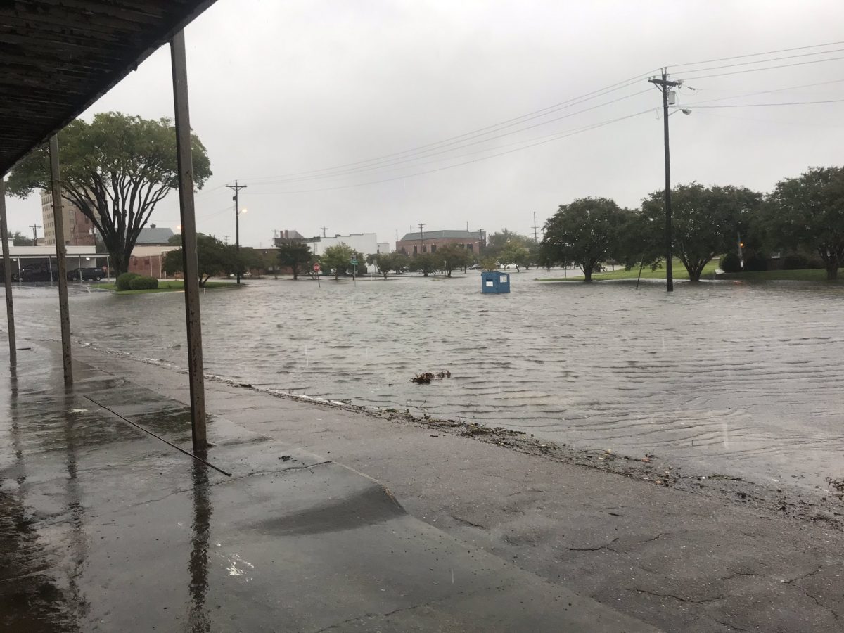 |
| Coastal Flooding in Ocean City, MD | Flooding in Colonial Place | Coastal Flooding in Elizabeth City |
Radar
Radar Loop and Selected Images
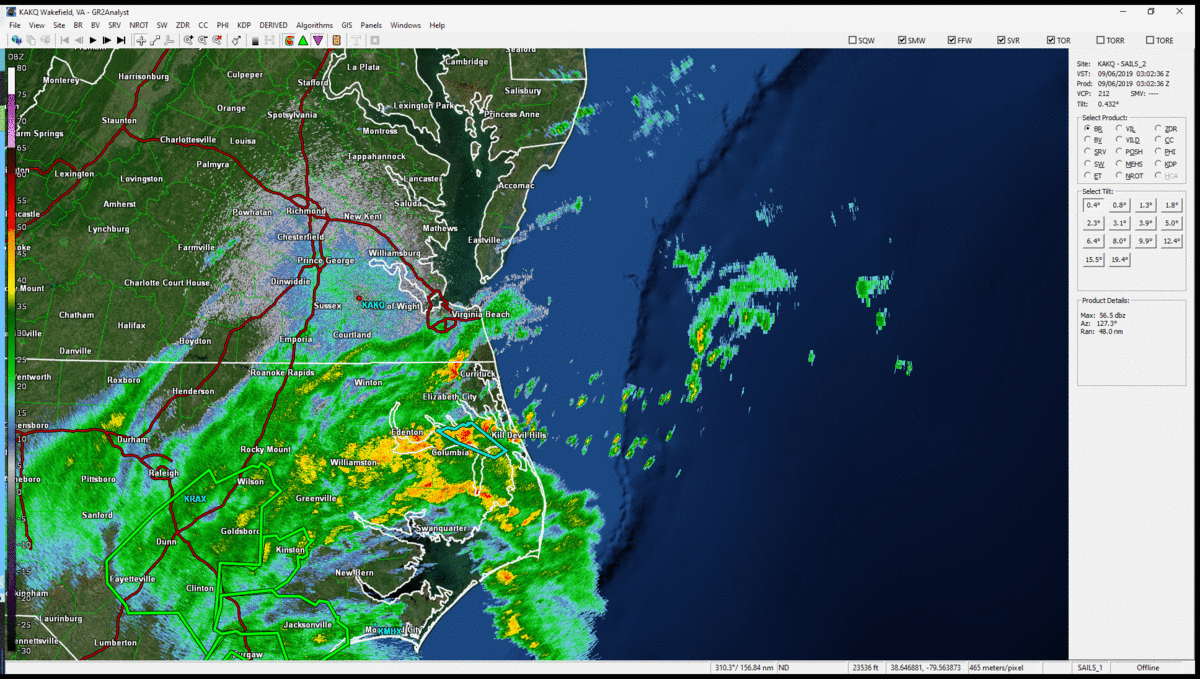 |
| Radar Loop of Hurricane Dorian with Warnings (from AKQ Radar) . Times are from 11 PM (9/5) to 3 PM (9/6) in ~30 minute increments. |
 |
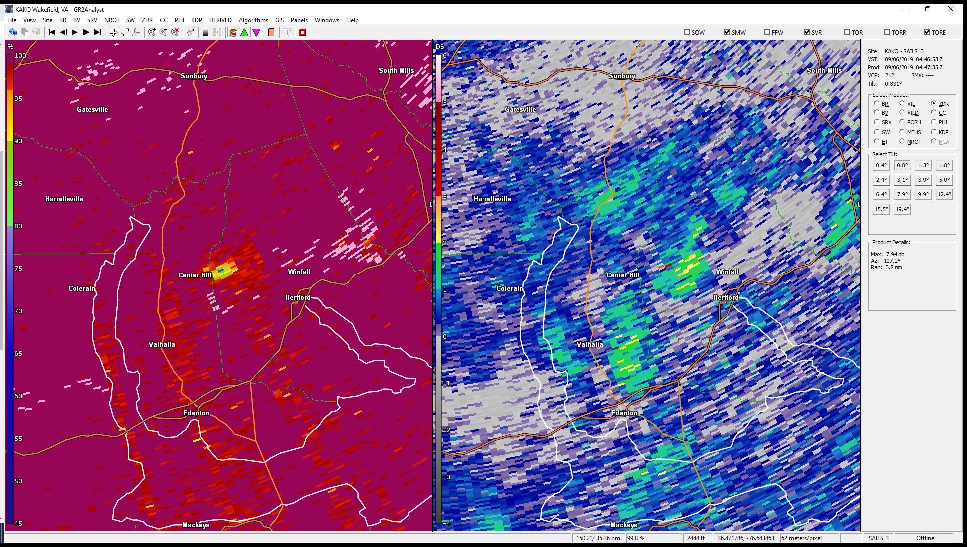 |
| 0.5° Reflectivity (left) and SRM (right) from just after the time of the Perquimans County tornado. | 0.5° Correlation Coefficient (left) and ZDR (right) from the same time as the corresponding Reflectivity/Velocity images that are shown to the left. Note the area of lower CC showing a possible tornado debris signature. |
Storm Reports
..TIME...   ...EVENT...      ...CITY LOCATION...     ...LAT.LON...
..DATE...   ....MAG....      ..COUNTY LOCATION..ST.. ...SOURCE....
            ..REMARKS..

0800 AM     FLASH FLOOD      1 ESE ELIZABETH CITY    36.29N 76.21W
09/06/2019                   PASQUOTANK         NC   BROADCAST MEDIA

            FLORA STREET IMPASSABLE DUE TO FLOODING.
0800 AM     NON-TSTM WND DMG ELIZABETH CITY          36.30N 76.22W
09/06/2019                   PASQUOTANK         NC   BROADCAST MEDIA

            TREES UPROOTED AND POWERLINES DOWN IN
            ELIZABETH CITY.
0901 AM     NON-TSTM WND DMG CURRITUCK               36.45N 76.02W
09/06/2019                   CURRITUCK          NC   PUBLIC

            SEVERAL TREES AND POWERLINES DOWN DUE TO
            HIGH WINDS.
0855 AM     NON-TSTM WND DMG SIGMA                   36.73N 75.98W
09/06/2019                   CITY OF VIRGINIA BEVA   BROADCAST MEDIA

            TREE DOWN ON SANDBRIDGE ROAD JUST OUTSIDE OF
            VIRGINIA BEACH.
0911 AM     FLASH FLOOD      ELIZABETH CITY          36.30N 76.22W
09/06/2019                   PASQUOTANK         NC   PUBLIC

            STREET/ROAD FLOODING; STREET/ROAD CLOSED;
            VEHICLES STRANDED.
1045 AM     FLASH FLOOD      1 NW WINFALL            36.22N 76.46W
09/06/2019                   PERQUIMANS         NC   DEPT OF HIGHWAYS

            NC DOT REPORTED THAT FOWLER FORT ROAD IS
            CLOSED DUE TO FLOODING.
1151 AM     COASTAL FLOOD    CURRITUCK               36.45N 76.02W
09/06/2019                   CURRITUCK          NC   TRAINED SPOTTER

            ACCESS ON ROUTE 168 TO THE OUTER BANKS CUT
            OFF AT HIGH TIDE.
1200 PM     FLASH FLOOD      1 SSE ELIZABETH CITY    36.28N 76.21W
09/06/2019                   PASQUOTANK         NC   LAW ENFORCEMENT

            FLASH FLOODING REPORTED ON SEVERAL CAMPUS
            STREETS AT ELIZABETH CITY STATE UNIVERSITY.
            IN ADDITION, SEVERAL BUILDINGS HAVE WATER IN
            INTERIOR ENTRANCES.
1240 PM     NON-TSTM WND DMG 4 NW MUNDEN             36.61N 76.08W
09/06/2019                   CITY OF VIRGINIA BEVA   PUBLIC

            TREE LIMBS BROKEN; SHINGLES BLOWN OFF.
0900 AM     TROPICAL STORM   NORVIEW                 36.89N 76.25W
09/06/2019                   CITY OF NORFOLK    VA   FIRE DEPT/RESCUE

            LARGE TREE FELL ON HOUSE REPORTED AT NORVIEW
            NORFOLK, VA.
1230 PM     HURRICANE        KNOTTS ISLAND           36.52N 75.93W
09/06/2019                   CURRITUCK          NC   PUBLIC

            POWER LINES DOWN, POWER POLES SNAPPED,
            MULTIPLE TREES DOWN.
1256 PM     HURRICANE        3 SE MUNDEN             36.54N 76.00W
09/06/2019                   CURRITUCK          NC   PUBLIC

            SHINGLES BLOWN OFF.
1050 AM     TROPICAL STORM   3 S NORFOLK INTERNATION 36.86N 76.21W
09/06/2019                   CITY OF NORFOLK    VA   PUBLIC

            POWER POLES BROKEN.
1158 AM     TROPICAL STORM   2 W NORTHWEST           36.57N 76.23W
09/06/2019                   CITY OF CHESAPEAKE VA   PUBLIC

            SHINGLES BLOWN OFF.
1205 PM     TROPICAL STORM   5 W NORTHWEST           36.60N 76.28W
09/06/2019                   CITY OF CHESAPEAKE VA   PUBLIC

            POWER POLES BROKEN.
1230 PM     TROPICAL STORM   4 SE FENTRESS           36.66N 76.15W
09/06/2019                   CITY OF CHESAPEAKE VA   PUBLIC

            POWER POLES BROKEN.
1250 PM     TROPICAL STORM   MUNDEN                  36.58N 76.02W
09/06/2019                   CITY OF VIRGINIA BEVA   PUBLIC

            TREES UPROOTED OR SNAPPED; ROOF BLOWN OFF.
1254 PM     TROPICAL STORM   2 SE MUNDEN             36.56N 76.01W
09/06/2019                   CITY OF VIRGINIA BEVA   PUBLIC

            3-INCH TREE LIMBS BROKEN; POWER POLES
            BROKEN.
0305 PM     COASTAL FLOOD    2 S CHINCOTEAGUE        37.92N 75.35W
09/06/2019                   ACCOMACK           VA   PUBLIC

            STREET/ROAD FLOODING; STREET/ROAD CLOSED;
            VEHICLES STRANDED.
0153 PM     TROPICAL STORM   1 W HALLWOOD            37.07N 76.32W
09/06/2019                   CITY OF HAMPTON    VA   PUBLIC

            WIND GUST TO 55 MPH.
0325 PM     STORM SURGE      2 N GHENT               36.90N 76.30W
09/06/2019                   CITY OF NORFOLK    VA   PUBLIC

            STREET/ROAD FLOODING; STREET/ROAD CLOSED;
            VEHICLES STRANDED.
0240 PM     STORM SURGE      1 W RESCUE              36.99N 76.56W
09/06/2019                   ISLE OF WIGHT      VA   PUBLIC

            STREET/ROAD FLOODING; STREET/ROAD CLOSED;
            VEHICLES STRANDED.
0324 PM     TROPICAL STORM   2 N GHENT               36.90N 76.30W
09/06/2019                   CITY OF NORFOLK    VA   PUBLIC

            3-INCH TREE LIMBS BROKEN; POWER POLES
            BROKEN.
0220 PM     TROPICAL STORM   BAYSIDE                 36.90N 76.14W
09/06/2019                   CITY OF VIRGINIA BEVA   PUBLIC

            3-INCH TREE LIMBS BROKEN; POWER POLES
            BROKEN.
1238 AM     TORNADO          3 SW PARKVILLE          36.27N 76.44W
09/06/2019                   PERQUIMANS         NC   EMERGENCY MNGR

            A WEAK TORNADO TRACKED THROUGH FARMLAND
            LEAVING A WELL DEFINED TRACK IN THE FIELD
            NEAR FOUR MILE DESERT RD.
Rainfall Reports
Public Information Statement
National Weather Service Wakefield VA
1151 AM EDT Fri Sep 6 2019

...PRECIPITATION REPORTS...

Location                     Amount    Time/Date       Lat/Lon
Mariner`S Warf Park          7.33 in   1100 AM 09/06   36.30N/76.22W
Chapanoke                    7.25 in   0715 AM 09/06   36.24N/76.36W
Elizabeth City Airport       6.99 in   1139 AM 09/06   36.27N/76.18W
Shiloh                       5.07 in   1115 AM 09/06   36.26N/76.10W
Greens Cross                 4.72 in   1117 AM 09/06   36.02N/76.89W
Hertford                     4.29 in   1121 AM 09/06   36.18N/76.47W
Hertford                     4.02 in   0956 AM 09/06   36.18N/76.47W
South Mills                  3.56 in   1123 AM 09/06   36.45N/76.30W
Hertford                     3.41 in   1115 AM 09/06   36.16N/76.32W
Virginia Beach               2.89 in   1125 AM 09/06   36.77N/76.04W
Greenbrier                   2.82 in   1139 AM 09/06   36.79N/76.22W
Virginia Beach               2.70 in   1125 AM 09/06   36.78N/76.14W
Joyce Creek Intracoastal Wat 2.56 in   1000 AM 09/06   36.44N/76.33W
Fentress Naval               2.46 in   1132 AM 09/06   36.70N/76.13W
Virginia Beach               2.46 in   1125 AM 09/06   36.75N/75.99W
Chesapeake                   2.34 in   1116 AM 09/06   36.69N/76.21W
Oceana NAS Souce             2.29 in   1139 AM 09/06   36.82N/76.02W
Ahoskie Tri Coun             1.62 in   1135 AM 09/06   36.28N/77.17W
Ghent                        1.60 in   1139 AM 09/06   36.86N/76.30W
1 SSE Kempsville             1.21 in   1139 AM 09/06   36.81N/76.16W
Suffolk                      1.03 in   1135 AM 09/06   36.68N/76.60W
&&
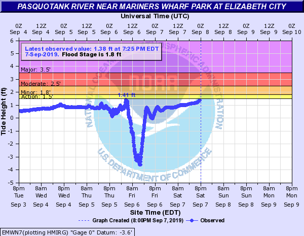
Tidal Flooding
Here are 11 hydrographs from selected locations in the AKQ Forecast Area, with one (Duck, NC) just outside the forecast area.
***ALL WATER LEVELS ARE REFERENCD TO MEAN LOWER LOW WATER (MLLW).
 |
 |
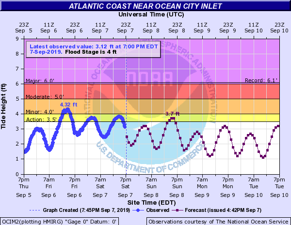 |
| Duck, NC | Wachapreague, VA | Ocean City, MD |
 |
 |
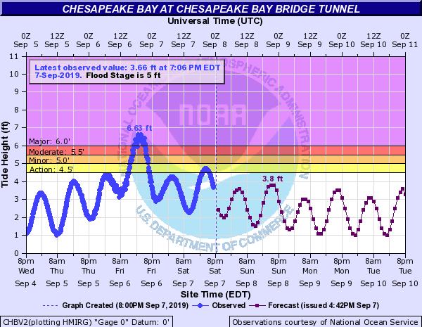 |
| Edenton, NC (Chowan River) | Elizabeth City, NC (Pasquotank River) | Chesapeake Bay Bridge Tunnel |
 |
 |
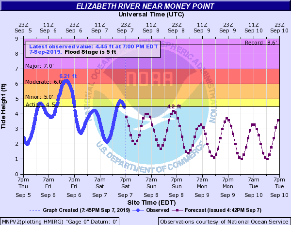 |
| Jamestown, VA (Upper James River) | Sewell's Point, VA (Lower James River) | Money Point, VA (Elizabeth River) |
 |
 |
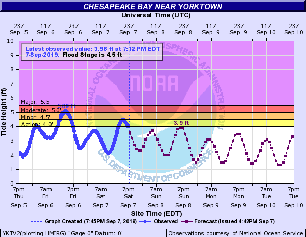 |
| Kiptopeke, VA (Southern Northampton County) | Bayford,VA (Northern Northampton County) | Yorktown, VA (Western Chesapeake Bay) |
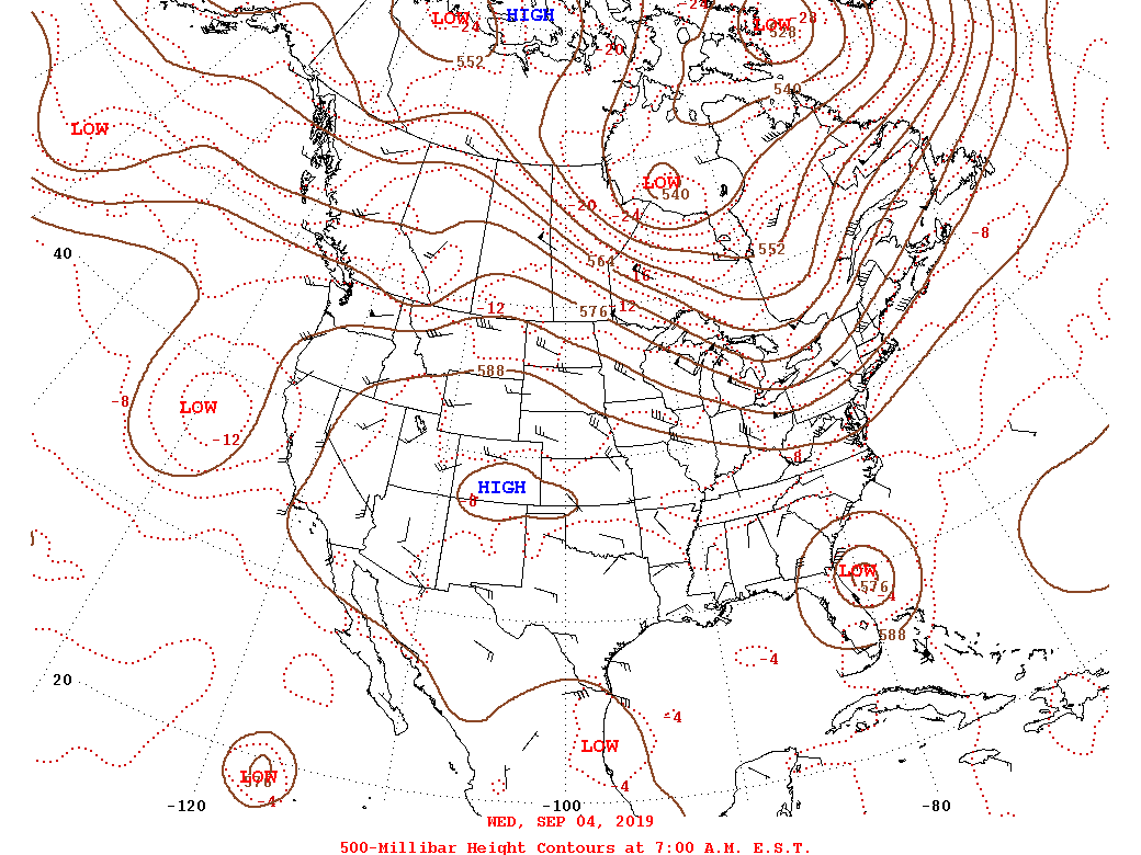
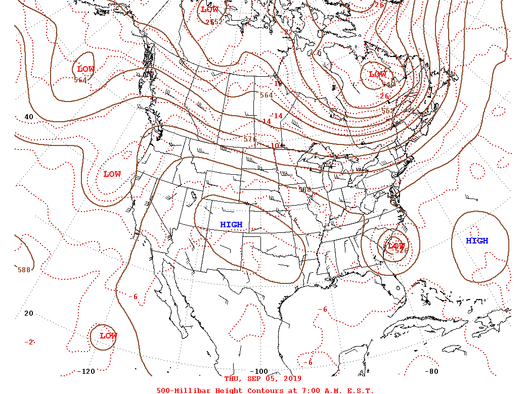
Environment
Upper level synoptic summary.
 |
 |
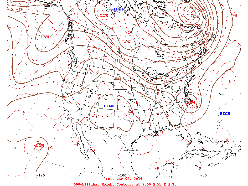 |
| 9/4 - 12z/8 AM 500mb Analysis | 9/5 - 12z/8 AM 500mb Analysis | 9/6 - 8 AM 500mb Analysis |
Surface synoptic summary.
 |
 |
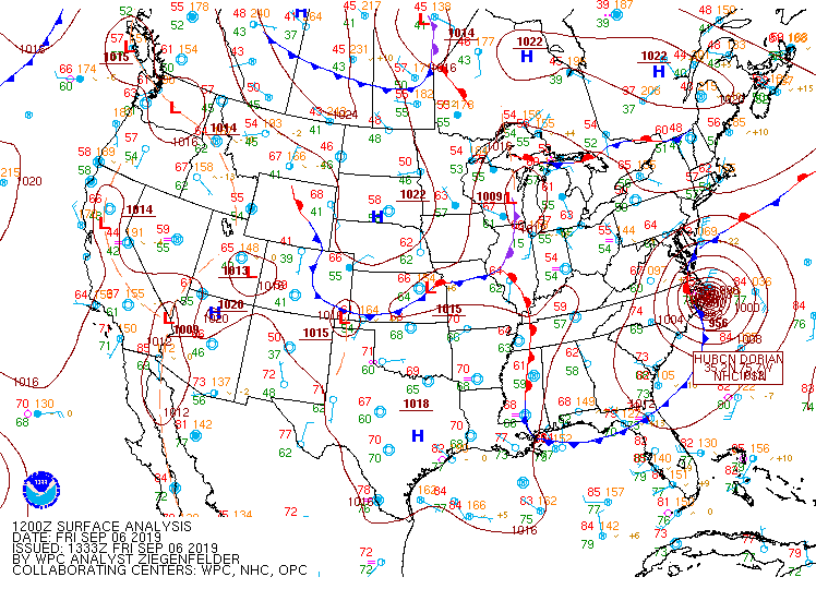 |
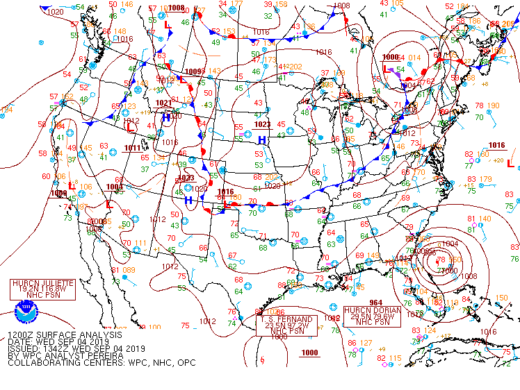
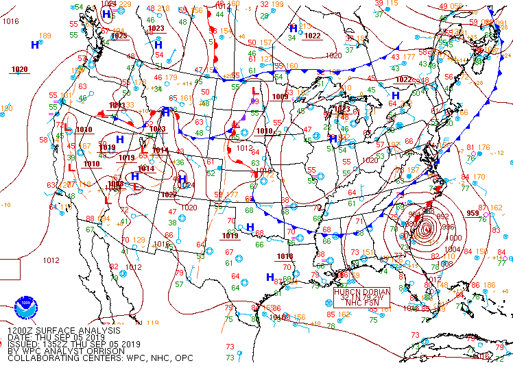
| 9/4 - 12z/8 AM WPC Surface Analysis | 9/5 - 12z/8 AM WPC Surface Analysis | 9/6 - 12z/8 AM WPC Surface Analysis |
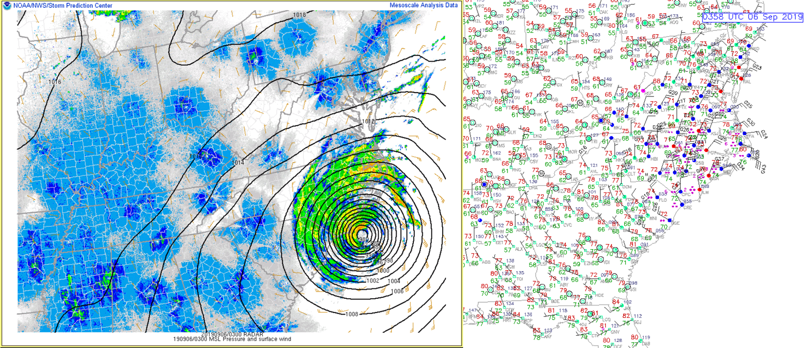
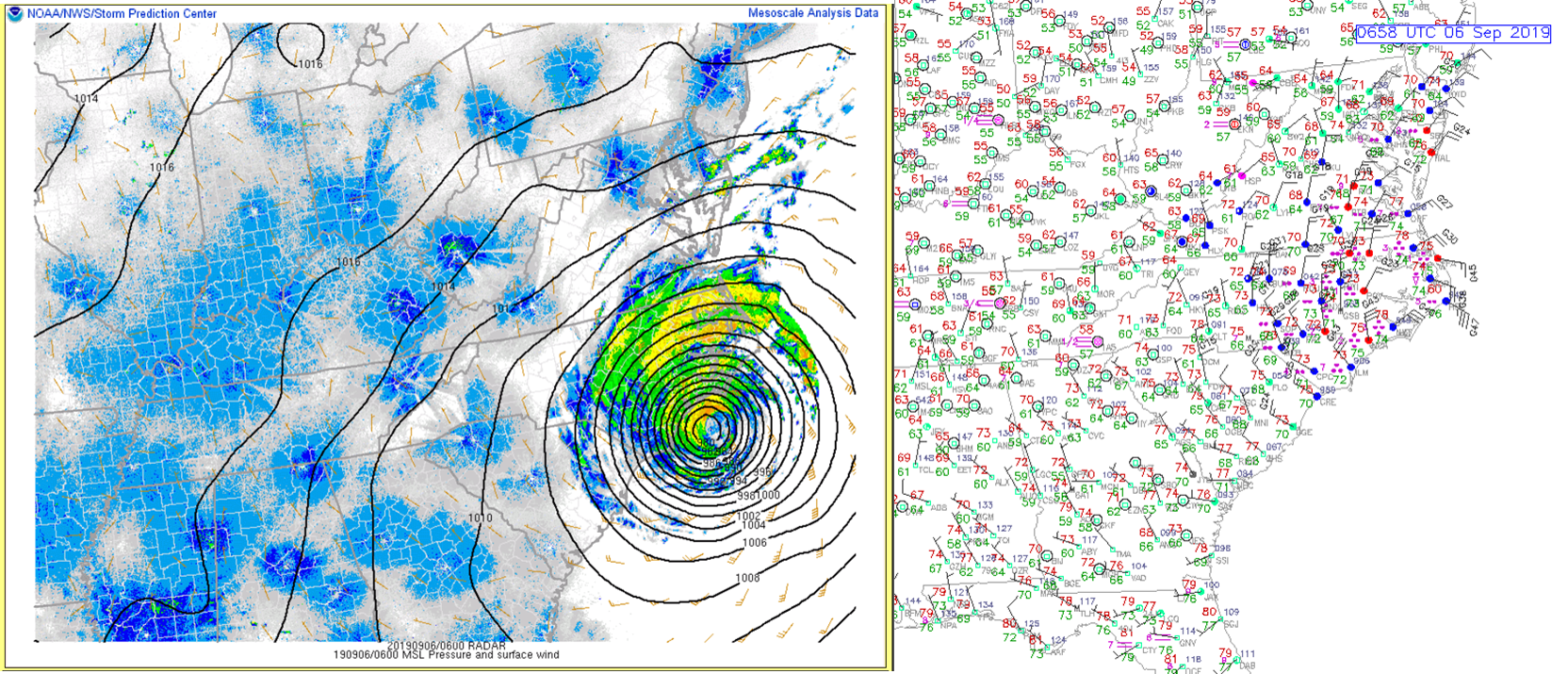
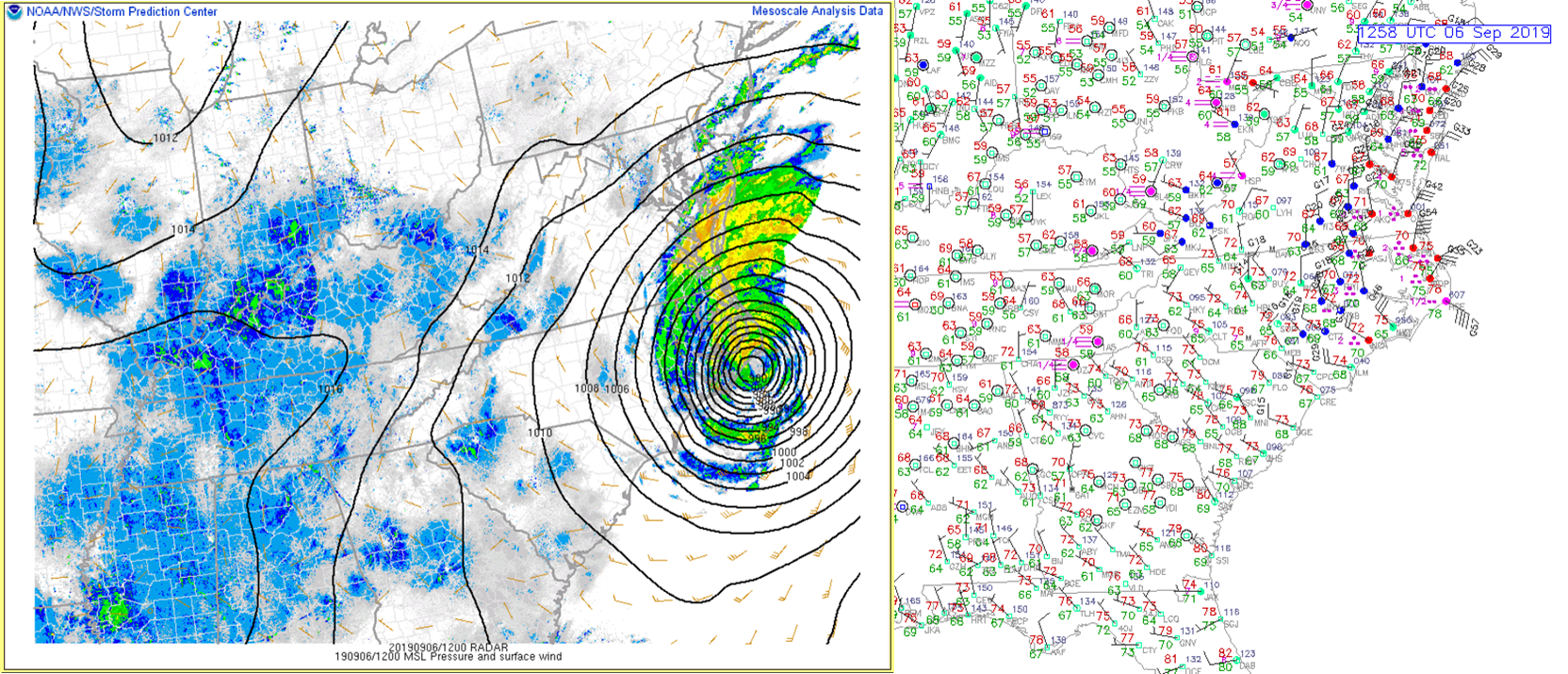
Regional Surface Analysis/Observations
 |
 |
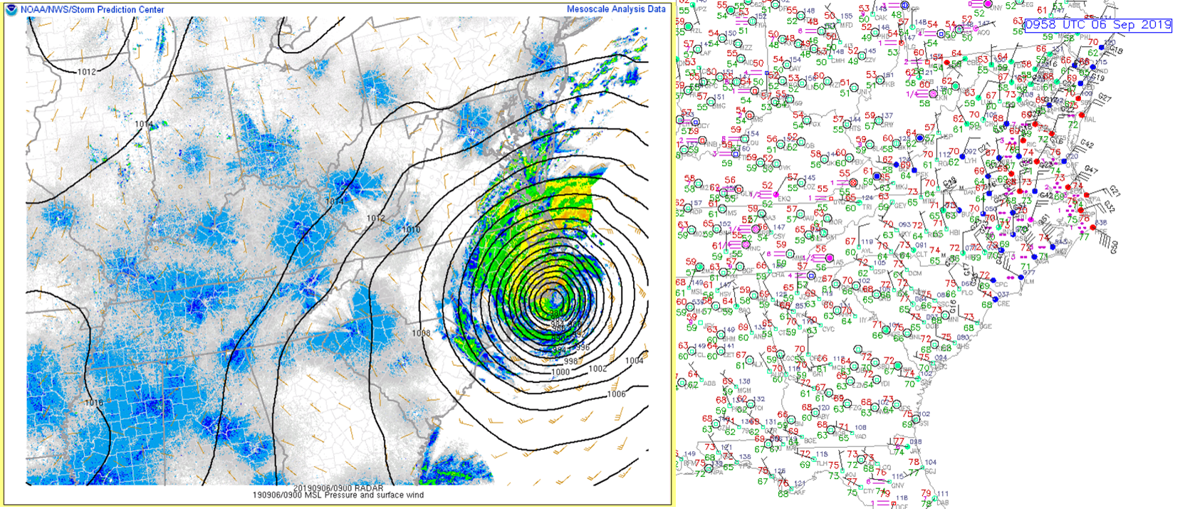 |
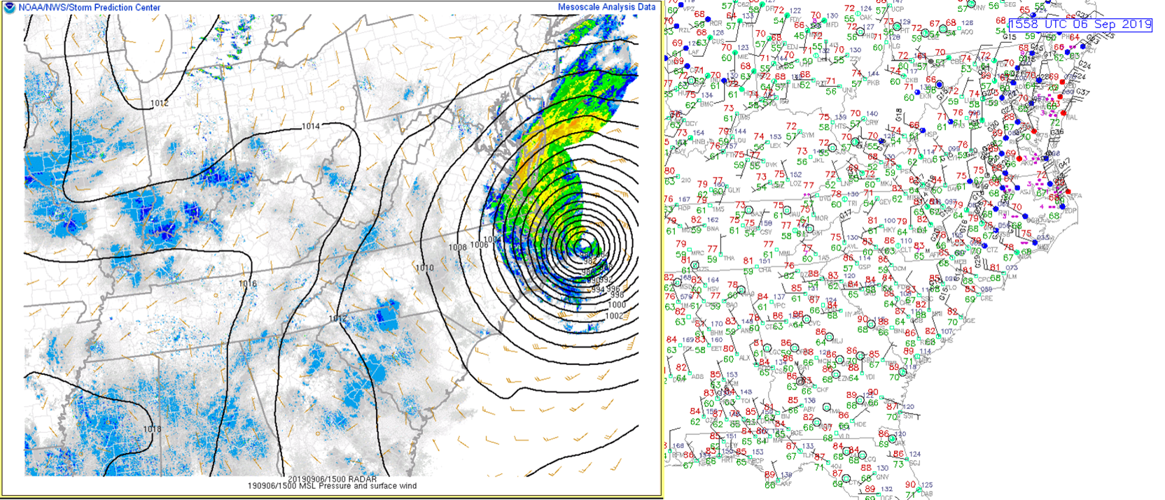
| 03z/11 PM (9/5) Regional Surface Analysis | 06z/2 AM Regional Surface Analysis | 09z/5 AM Regional Surface Analysis |
 |
 |
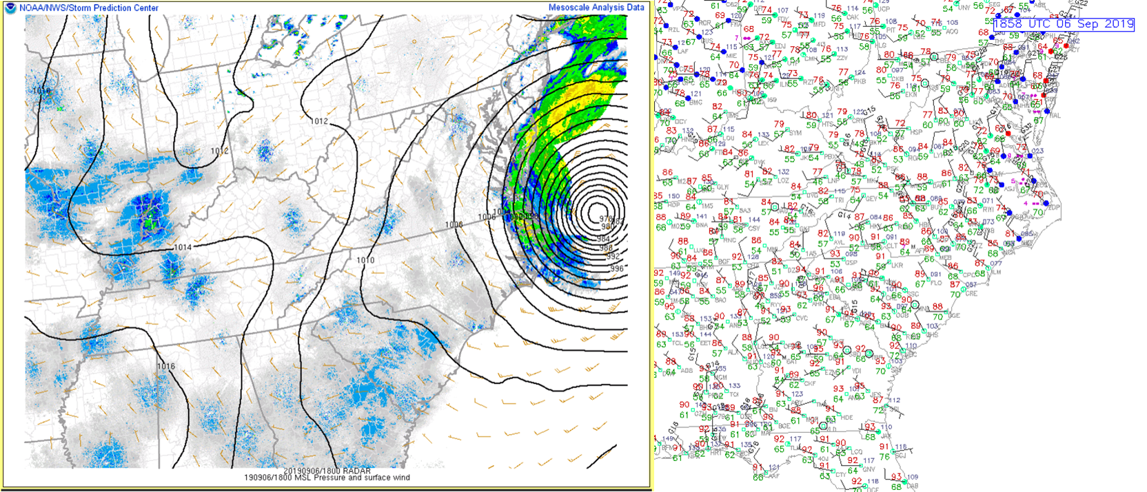 |
| 12z/8 AM Regional Surface Analysis | 15z/11 AM Regional Surface Analysis | 18z/2 PM Regional Surface Analysis |
 |
 |
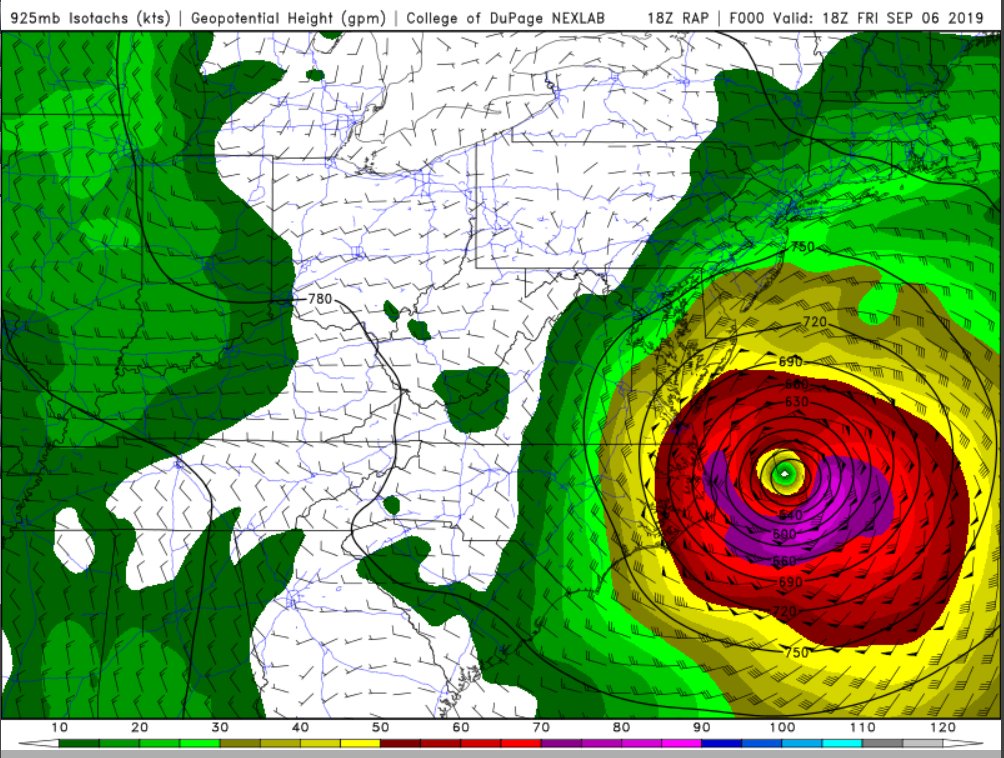 |
| 12z/8 AM RAP 925 mb Analysis | 15z/11 AM RAP 925 mb Analysis | 18z/2 PM RAP 925 mb Analysis |
 |
 |
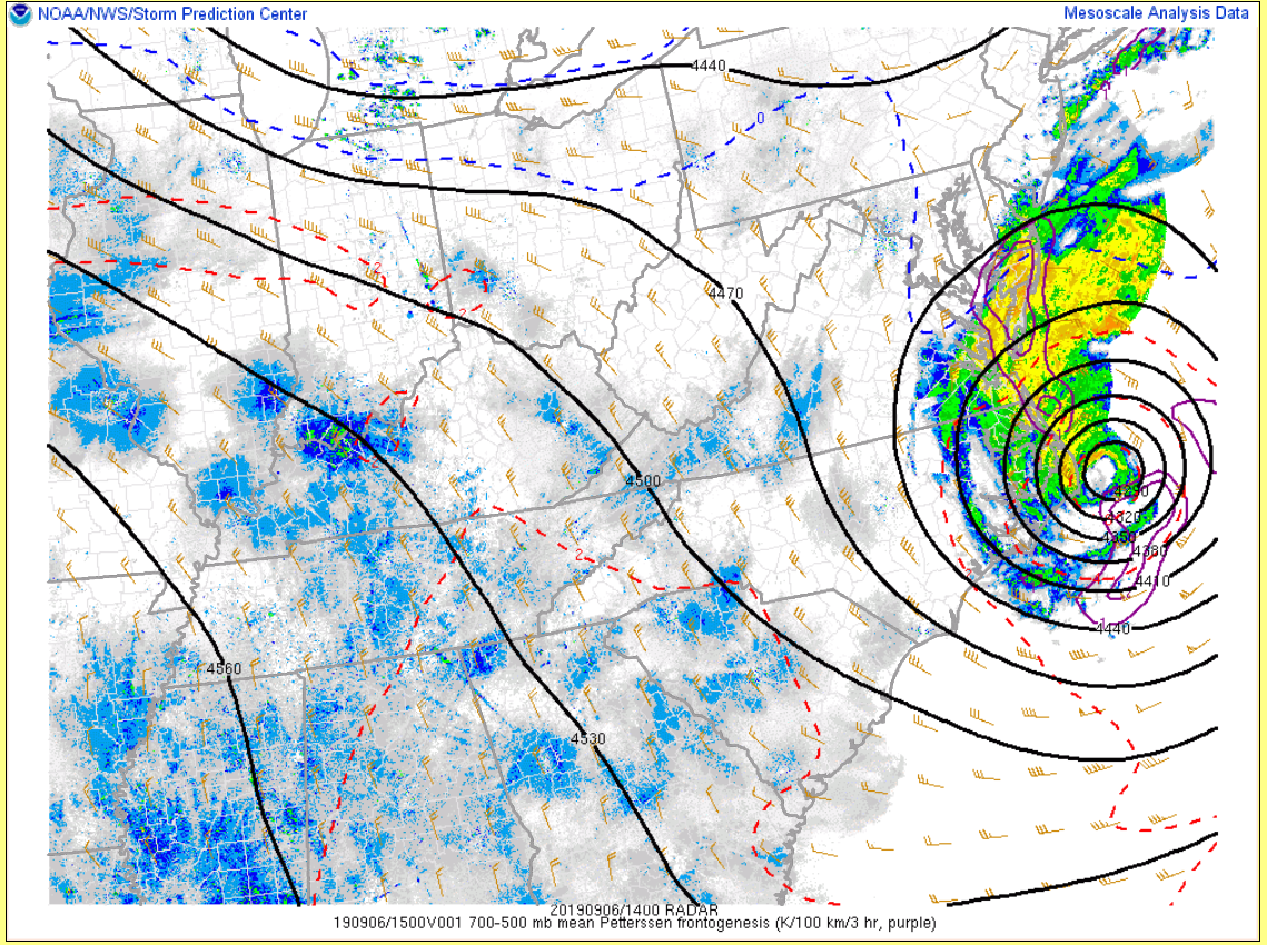 |
| 03z/11 PM 0-1 km Storm Relative Helicity | 03z/11 PM RAP Analysis Sounding from Edenton,NC | 14z/10 AM 700-500 mb Frontogenesis |
 |
Media use of NWS Web News Stories is encouraged! Please acknowledge the NWS as the source of any news information accessed from this site. |
|


 Coastal Flood
 Heat
Heat