Overview
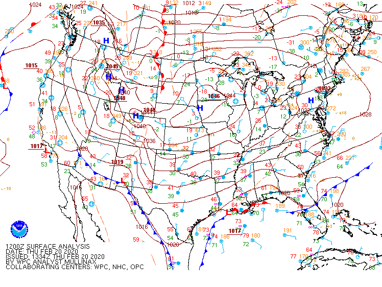
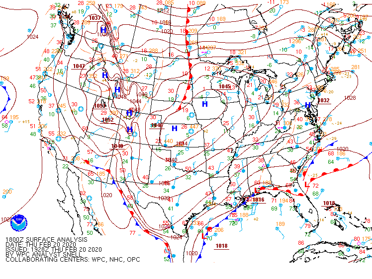
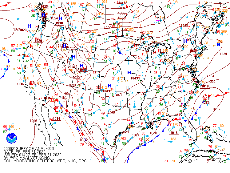
On the morning of February 20th, an expansive area of strong (~1048 mb) high pressure located from the Rockies to the Midwest was slowly building to the southeast. Weak low pressure was developing along a frontal boundary draped from the Gulf coast to just off the Atlantic coast of FL/GA. Aloft, a northern stream upper level shortwave trough was diving from the northern Great Lakes to the Ohio Valley, while a series of fast-moving southern stream upper disturbances in W-WSW (zonal) flow aloft were moving from the southern Plains to VA and the Carolinas. The upper shortwave tracked from the OH Valley to VA/NC from the afternoon of 2/20 to the early morning of 2/21 while the surface low slowly intensified as it tracked to the northeast (well offshore of the Carolina coast).
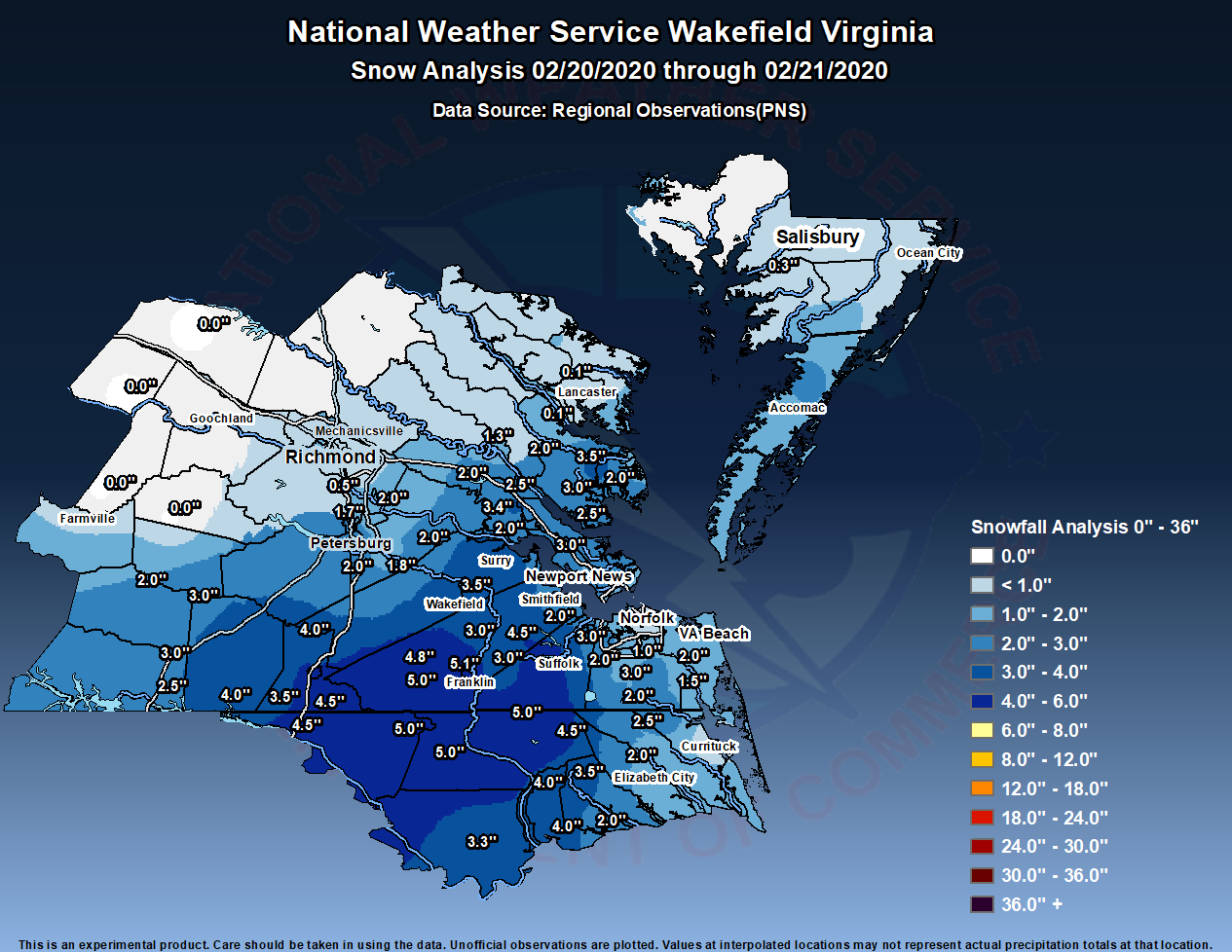
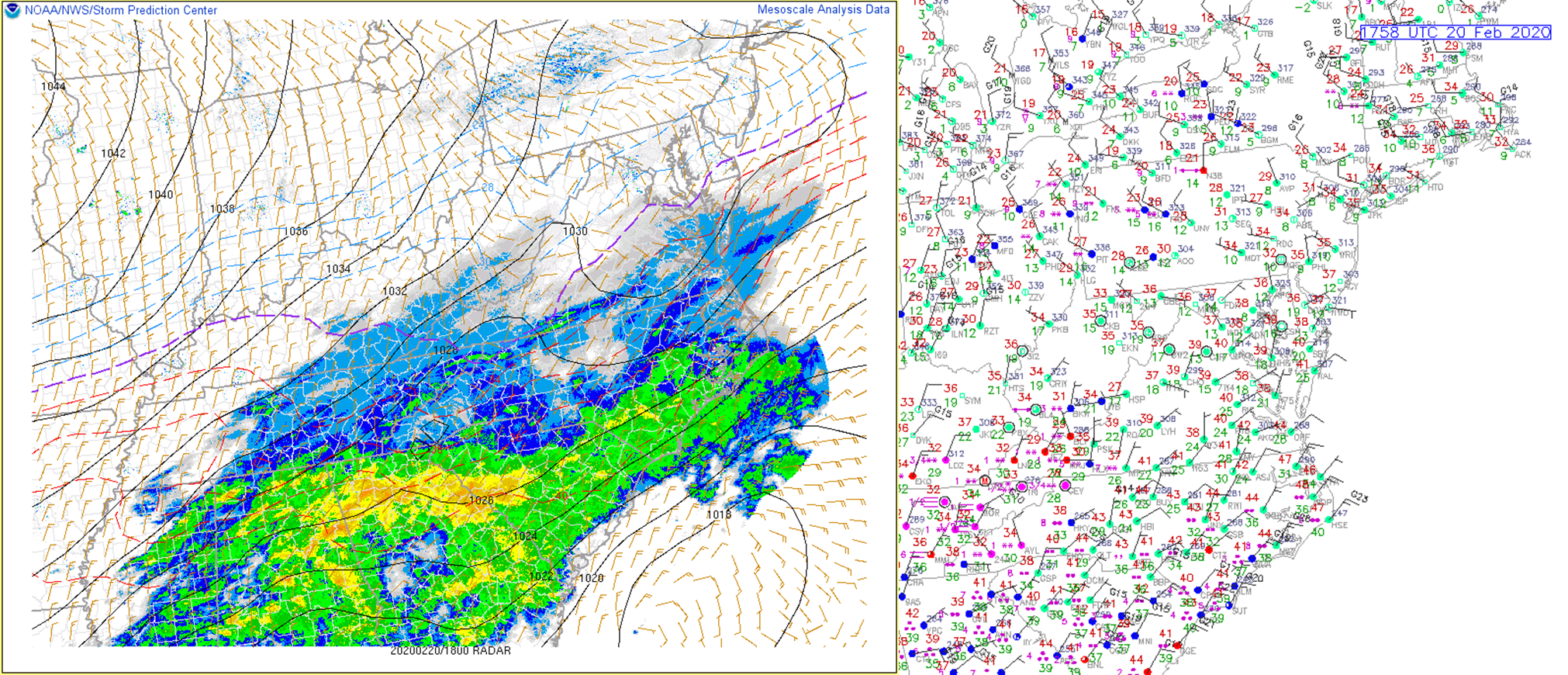
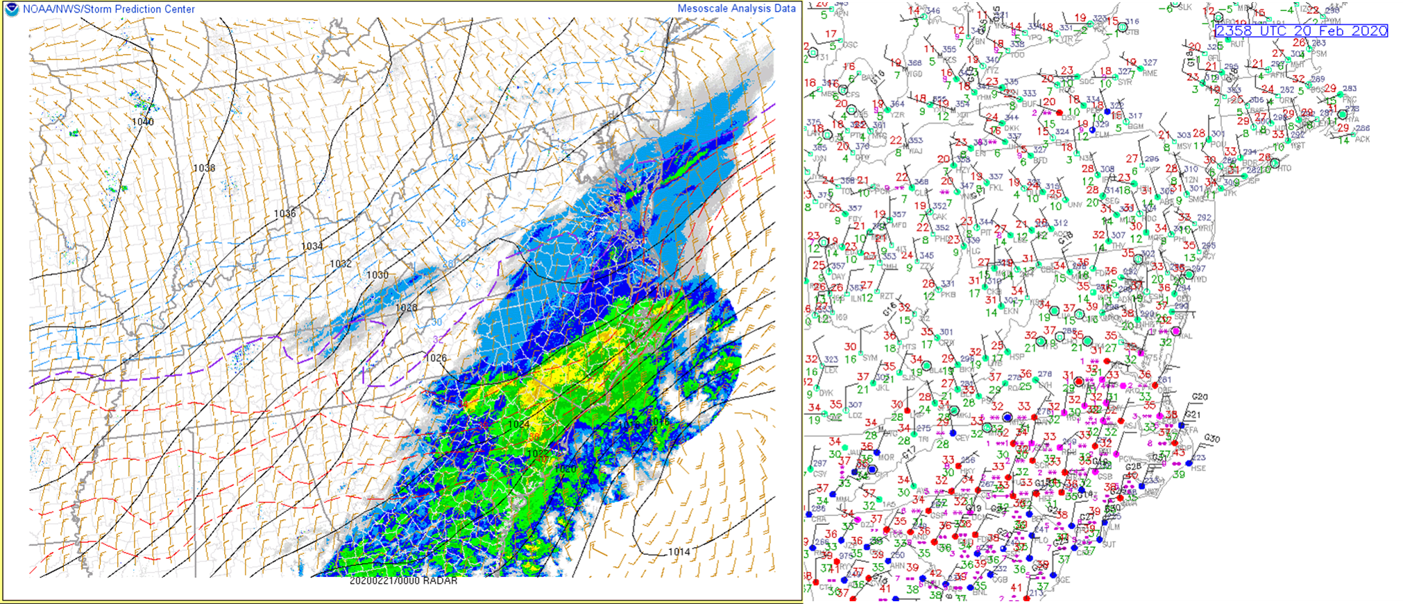
Temperatures were mainly in the low-mid 30s across much of the area with an overcast mid-high cloud deck Thursday morning. However, it was quite dry below 10000 ft. While regional radar mosaic showed precipitation overspreading the area by midday-early afternoon off the GA/SC coast, nothing (save for a few sprinkles) was reaching the ground. In fact, it had warmed into the low 40s across much of the area by 1-2 PM with dew points in the 20s. This resulted in wet-bulb temperatures in the mid to upper 30s across southern VA/NE NC, with low-mid 30s across the northwest half of the CWA. However, the atmospheric column over southern VA/NE NC quickly saturated from the top down during the 2-3 PM timeframe. Temperatures quickly dropped into the 32-36F range (a couple degrees below the wet-bulb). This was likely due to latent cooling as falling snow melted/sublimated as the column first saturated. Precipitation quickly changed to snow by 3-5 PM across most interior sections of SE VA/NE NC. Even by 5 PM, the low-levels remained too dry for precipitation to reach the ground northwest of a Farmville-Petersburg-Salisbury (MD) line. Snow continued to fall for the next several hours across interior SE VA/NE NC. Snow began from the Richmond metro to the VA Eastern Shore at 5-6 PM (where temperatures quickly fell to 31-33°F) before ending a few hours later. Precipitation eventually changed to mostly snow in areas near the coast by 7-9 PM, but temperatures remained in the 34-36°F range for the majority of the night in areas very close to the coast (due to strong NNE flow off the 45°F water). See the "Observations" section for more detailed surface obs during selected hours of the event (which showed the warmer air coming off the water from the NNE). These slightly warmer temperatures prevented any appreciable accumulations near the immediate coast. The snow ended from northwest to southeast from the late evening on 2/20 to the early morning hours on 2/21. Snowfall amounts were generally 1-2" from the southern Richmond metro to the VA Eastern Shore, with 2-5" over interior S/SE VA and NE NC. Amounts decreased closer to the coast, with generally less than 1" in areas near the immediate shoreline of the bay/ocean.
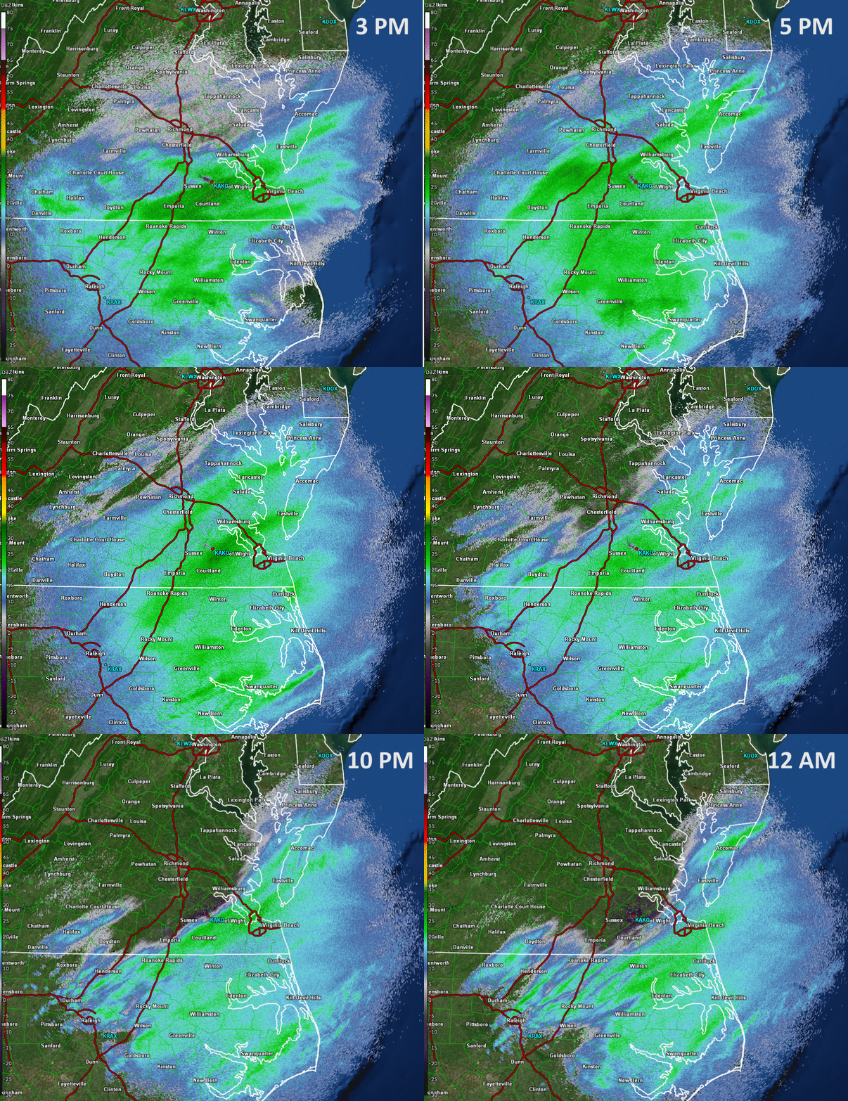
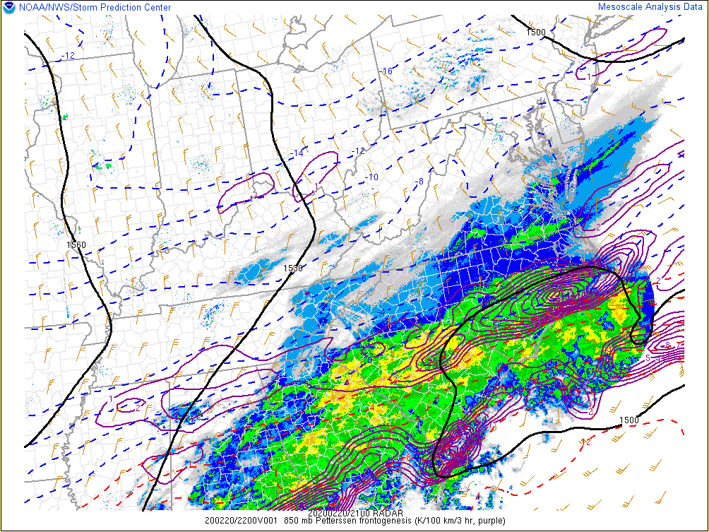
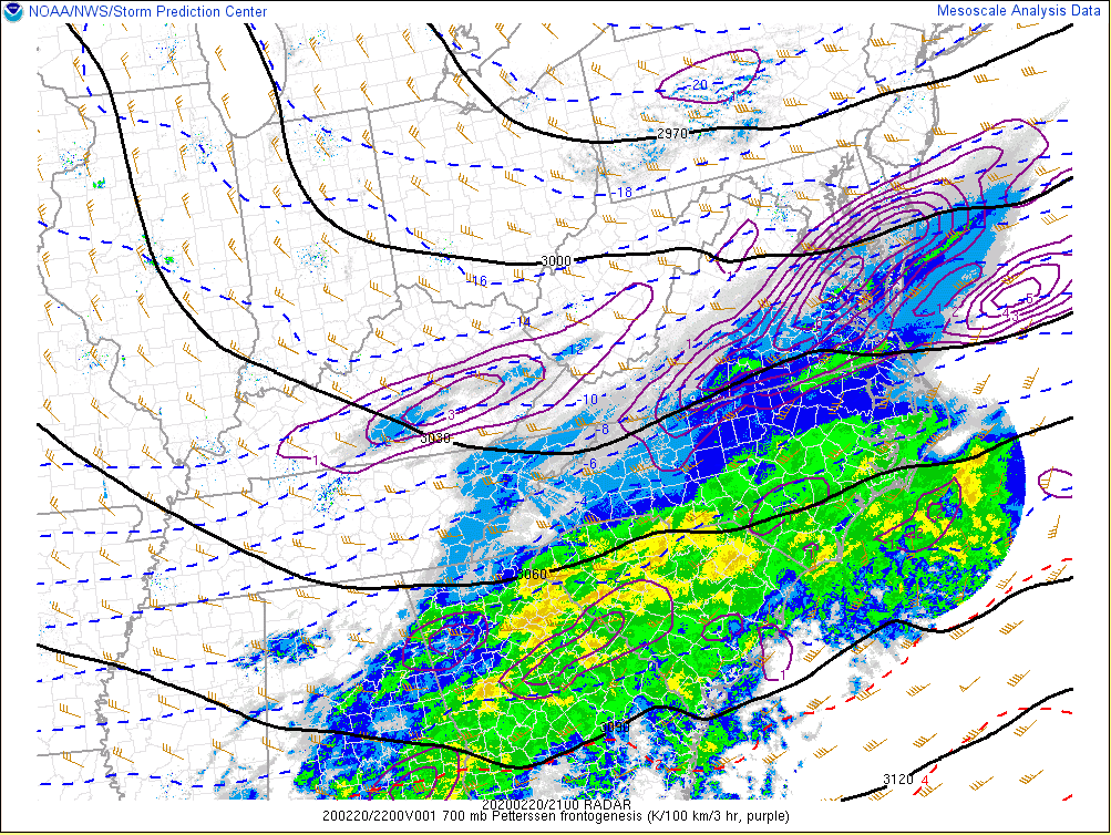
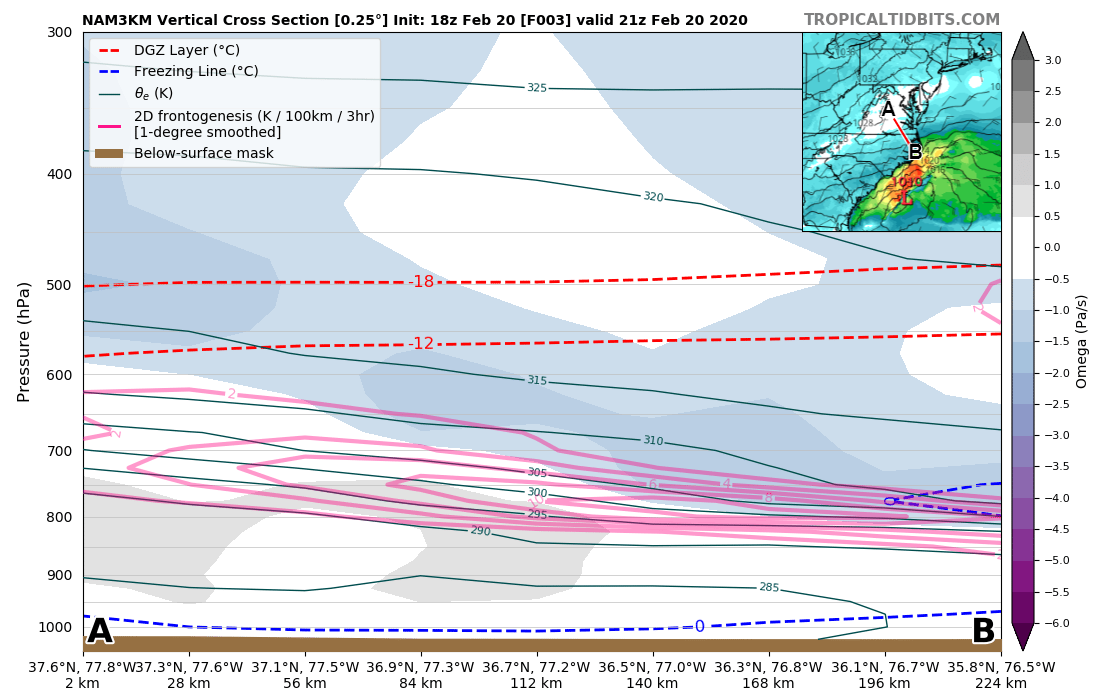
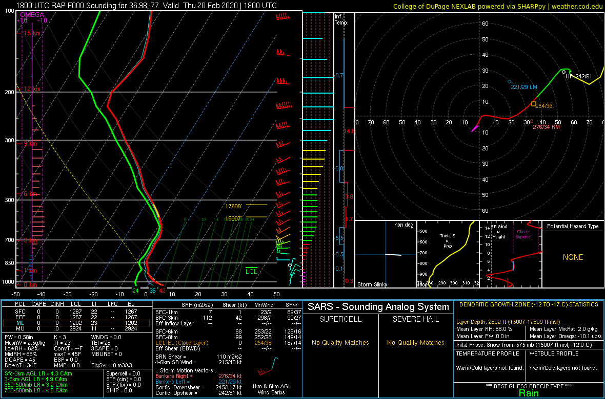
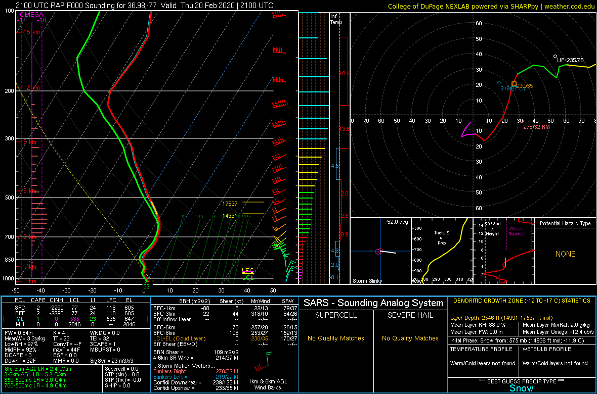
Despite the relatively long duration of the snow across parts of the area, there was not a single observation of heavy snow across the area. In fact, rates were largely 0.5-0.75" an hour or less throughout the entire event. Some banding associated with a WSW-ENE oriented band of 800-700 mb frontogenesis was evident on radar across SE VA during the mid afternoon-early evening. However, radar echoes diminished slightly in intensity after 7 PM, with mainly light snow observed after 6-7 PM. However, since the sun had set, the worst road conditions occurred after 6-7 PM as the wet snow started to stick to some roads. RAP/NAM analysis did show that the main band of frontogenesis (mainly from 800-700 mb) was located below the dendritic growth zone. In addition, soundings from SE VA showed some steeper lapse rates during the mid-late afternoon in the 650-500 mb layer, where there was perhaps some conditional/slantwise instability in the DGZ during the late afternoon-early evening (when radar echoes were most intense). However, this signature disappeared by 7 PM. See the "Environment" section for more details.
Snowfall Map
Photos
 |
 |
 |
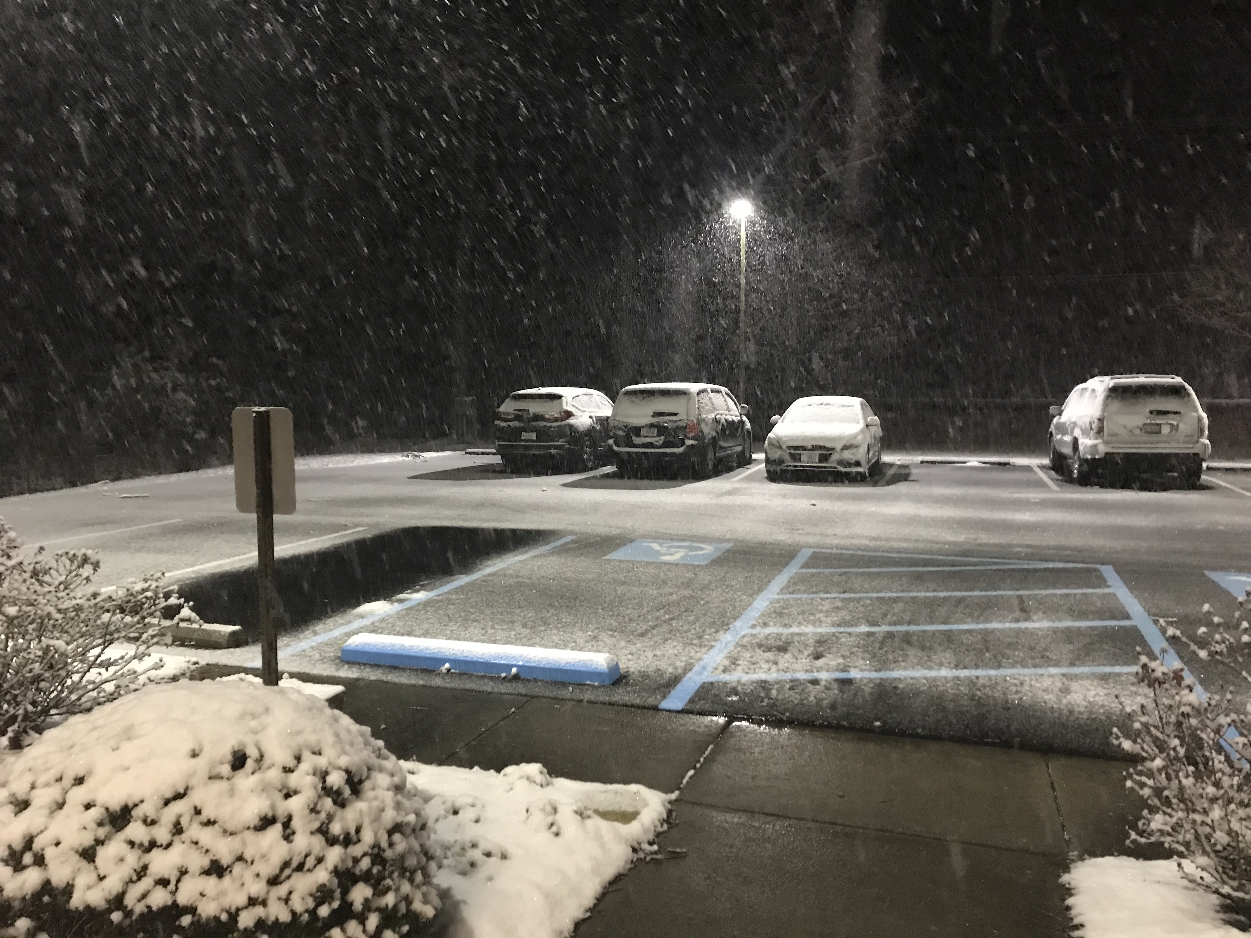
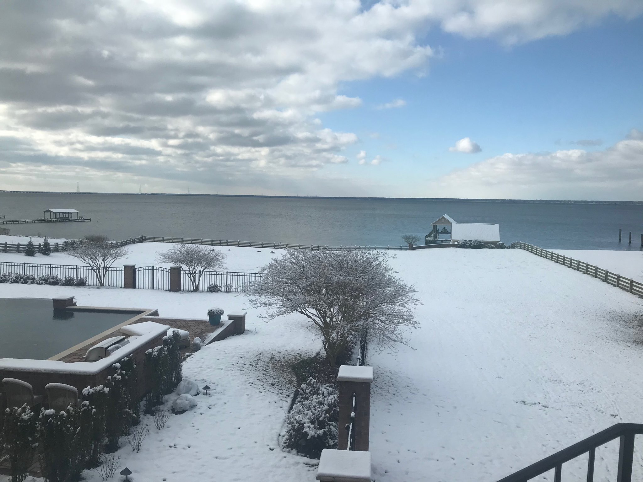
| Snow starting to accumulate in the NWS Wakefield parking lot at ~6:30 PM. | Snow in Newport News (Credit: Cheryl Nelson) |
Snow on the VA Eastern Shore (Credit: Miaya Dennis) |
Radar
Loop from 3 PM to Midnight in 30 Minute Increments
 |
Snowfall Reports
Public Information Statement
National Weather Service Wakefield VA
1006 AM EST Fri Feb 21 2020

...SNOWFALL REPORTS...

Location                     Amount    Time/Date       Provider

...Maryland...

...Somerset County...
Crisfield                    0.3 in    0938 PM 02/20   Broadcast Media
Eden                         0.3 in    0936 PM 02/20   Broadcast Media

...Worcester County...
Ocean City                   0.1 in    0939 PM 02/20   Broadcast Media

...North Carolina...

...Bertie County...
Windsor                      3.3 in    0640 AM 02/21   Public

...Chowan County...
Edenton                      4.0 in    0757 AM 02/21   Public
Smalls Crossroads            4.0 in    0700 AM 02/21   Public

...Currituck County...
3 NW Moyock                  2.5 in    0700 AM 02/21   Emergency Mngr
1 NNW Maple                  0.1 in    0800 AM 02/21   Public

...Gates County...
Gates                        5.0 in    0800 AM 02/21   Emergency Mngr
1 NW Sunbury                 4.5 in    0800 AM 02/21   Emergency Mngr

...Hertford County...
2 E Murfreesboro             5.0 in    0800 AM 02/21   Public

...Northampton County...
Conway                       5.0 in    0800 AM 02/21   Emergency Mngr
1 NNE Pleasant Hill          4.5 in    0800 AM 02/21   Emergency Mngr
Gaston                       4.5 in    0800 AM 02/21   Emergency Mngr

...Pasquotank County...
3 WSW Spences Corner         2.0 in    0610 AM 02/21   Public
2 ESE Elizabeth City         1.5 in    0700 AM 02/21   Cocorahs
1 NE Elizabeth City          1.4 in    0946 AM 02/21   CO-OP Observer

...Perquimans County...
Belvidere                    3.5 in    0800 AM 02/21   Emergency Mngr
Snug Harbor                  2.0 in    0800 AM 02/21   Public

...Virginia...

...Accomack County...
Bloxom                       2.5 in    1008 PM 02/20   Trained Spotter
Keller                       2.0 in    0800 AM 02/21   Dept of Highways
1 ESE Assawoman              2.0 in    0600 AM 02/21   Public
Quinby                       2.0 in    0942 PM 02/20   Public
2 NE Atlantic                1.0 in    0714 PM 02/20   CO-OP Observer
Chincoteague                 0.5 in    0938 PM 02/20   Broadcast Media

...Brunswick County...
Gasburg                      4.0 in    1000 PM 02/20   Public

...Chesterfield County...
2 SSE Meadowville            2.0 in    0800 AM 02/21   Cocorahs
3 S Meadowville              1.7 in    0739 PM 02/20   NWS Employee

...City of Chesapeake...
Western Branch               3.0 in    0800 AM 02/21   Public
1 SE Great Bridge            3.0 in    0600 AM 02/21   Public
1 ENE Bowers Hill            2.0 in    0700 AM 02/21   Cocorahs
3 SSE Hickory                2.0 in    1230 AM 02/21   Public
Mount Pleasant               1.5 in    0929 AM 02/21   Public

...City of Franklin...
1 NNW Franklin               5.1 in    1100 PM 02/20   Trained Spotter

...City of Newport News...
Beaconsdale                  3.0 in    0600 AM 02/21   Public
Newport News                 2.5 in    0757 AM 02/21   Public
1 ESE Oyster Point           1.7 in    1030 PM 02/20   Trained Spotter

...City of Norfolk...
2 SE Norview                 0.4 in    0120 AM 02/21   CO-OP Observer
2 N Ghent                    0.3 in    0708 AM 02/21   Public

...City of Petersburg...
1 W Petersburg               3.0 in    0817 PM 02/20   Trained Spotter

...City of Portsmouth...
Churchland                   1.5 in    0800 AM 02/21   Public
1 WNW Cradock                1.0 in    0605 AM 02/21   Public

...City of Suffolk...
2 WSW Kilby                  5.0 in    0919 AM 02/21   Public
2 NNW Kilby                  5.0 in    0915 AM 02/21   Public
Downtown Suffolk             4.0 in    0115 AM 02/21   Broadcast Media

...City of Virginia Beach...
2 WNW Princess Anne          2.0 in    1215 AM 02/21   Public
2 E Greenbrier               1.8 in    0600 AM 02/21   Public

...City of Williamsburg...
Williamsburg                 2.8 in    0849 AM 02/21   Public
Williamsburg                 2.0 in    0640 AM 02/21   Public

...Dinwiddie County...
1 NNW Addison                2.5 in    0732 AM 02/21   NWS Employee

...Gloucester County...
Ware Neck                    3.0 in    0900 AM 02/21   Public
1 NNW Gloucester Point       3.0 in    1100 PM 02/20   Public
Gloucester Point             2.5 in    0902 AM 02/21   Public

...Greensville County...
Purdy                        4.0 in    1044 PM 02/20   Trained Spotter
1 W Slates Corner            3.5 in    0630 AM 02/21   Public

...Henrico County...
1 W Fair Oaks                0.6 in    0815 PM 02/20   Trained Spotter
Varina                       0.5 in    0900 PM 02/20   CO-OP Observer
Montrose                     0.3 in    0800 AM 02/21   Cocorahs

...Isle of Wight County...
1 E Windsor                  4.5 in    0800 AM 02/21   Cocorahs
1 SSW Pons                   4.0 in    0800 AM 02/21   Cocorahs
Windsor                      3.3 in    0700 AM 02/21   Public
Windsor                      3.3 in    0700 AM 02/21   Public
3 SW Smithfield              3.0 in    0100 AM 02/21   NWS Employee
Zuni                         3.0 in    1100 PM 02/20   Broadcast Media
Carrsville                   3.0 in    0732 PM 02/20   Public
2 N Benns Church             2.0 in    0100 AM 02/21   NWS Employee

...James City County...
Lightfoot                    3.4 in    0952 PM 02/20   Public
Toano                        2.5 in    1000 PM 02/20   Public

...King William County...
1 N West Point               1.3 in    0925 AM 02/21   CO-OP Observer

...Lancaster County...
1 SE Mollusk                 0.1 in    0800 AM 02/21   Cocorahs

...Lunenburg County...
2 WNW Barrows Store          3.0 in    0804 AM 02/21   Public
1 NNE Victoria               2.0 in    0806 AM 02/21   Public

...Mathews County...
Soles                        3.5 in    1030 PM 02/20   Public
Mathews                      2.0 in    1030 PM 02/20   Public
Gwynn                        1.5 in    1009 PM 02/20   Trained Spotter

...Mecklenburg County...
South Hill                   3.0 in    0530 AM 02/21   Public
Bracey                       2.5 in    0756 AM 02/21   Public

...Middlesex County...
Saluda                       2.0 in    0530 AM 02/21   Public

...New Kent County...
1 ENE Lanexa                 2.0 in    0900 AM 02/21   Public

...Northampton County...
1 E Cape Charles             1.5 in    0659 AM 02/21   NWS Employee

...Northumberland County...
Howland                      0.1 in    0700 AM 02/21   Public

...Prince George County...
2 SSE Fort Lee               2.0 in    0930 PM 02/20   NWS Employee
2 SE Richard Bland College   2.0 in    0854 PM 02/20   NWS Employee
1 W Prince George            2.0 in    0830 PM 02/20   NWS Employee
4 NNW Barham                 2.0 in    0706 PM 02/20   NWS Employee
1 N Prince George Golf       1.8 in    0830 PM 02/20   NWS Employee

...Southampton County...
Courtland                    5.0 in    0245 AM 02/21   Public
4 W Courtland                4.8 in    0903 AM 02/21   Public

...Surry County...
1 SW Ellis Fork              3.5 in    0922 AM 02/21   Public
Surry                        3.5 in    0902 AM 02/21   Public
Elberon                      3.5 in    0800 AM 02/21   Public

...Sussex County...
1 NW Wakefield               3.6 in    1029 PM 02/20   Official NWS Obs

...York County...
Yorktown                     3.0 in    1210 AM 02/21   Public

&&
Environment
Synoptic Summary.
 |
 |
 |
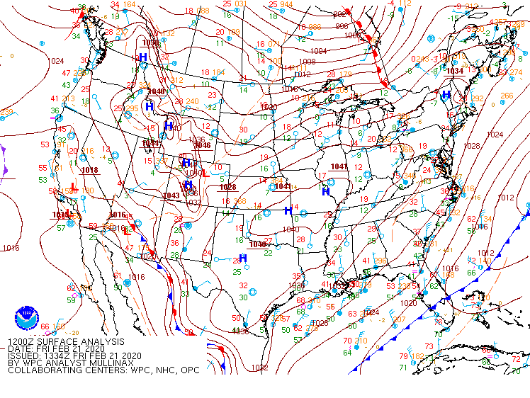 |
| 7 AM 2-20 WPC Surface Analysis | 1 PM 2-20 WPC Surface Analysis | 7 PM 2-20 WPC Surface Analysis | 7 AM 2-21 WPC Surface Analysis |
Taking a closer look at some parameters from 4 PM on 2-20.
 |
 |
 |
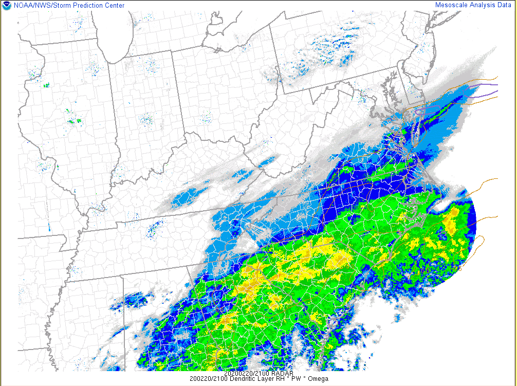 |
| 4 PM 850mb Frontogenesis | 4 PM 700mb Frontogenesis | 4 PM Cross section of FGen/Omega/Temperature | 4 PM OPRH...this is a parameter that is the product of vertical motion, PW, and RH in the Dendritic Growth Zone (shows how favorable conditions are for snow growth in the DGZ). |
Sounding data.
 |
 |
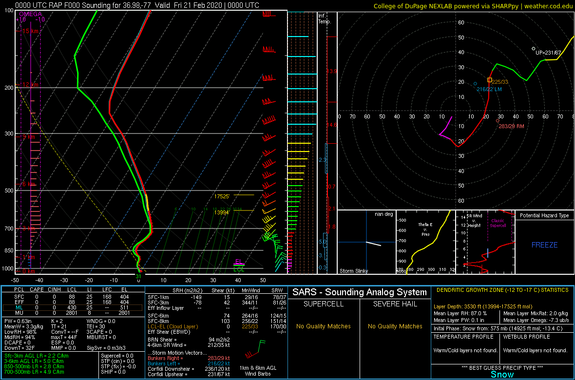 |
| 18z/1 PM RAP Analysis Sounding from KAKQ | 21z/4 PM RAP Analysis Sounding from KAKQ | 00z/7 PM RAP Analysis Sounding from KAKQ |
Regional Observations
 |
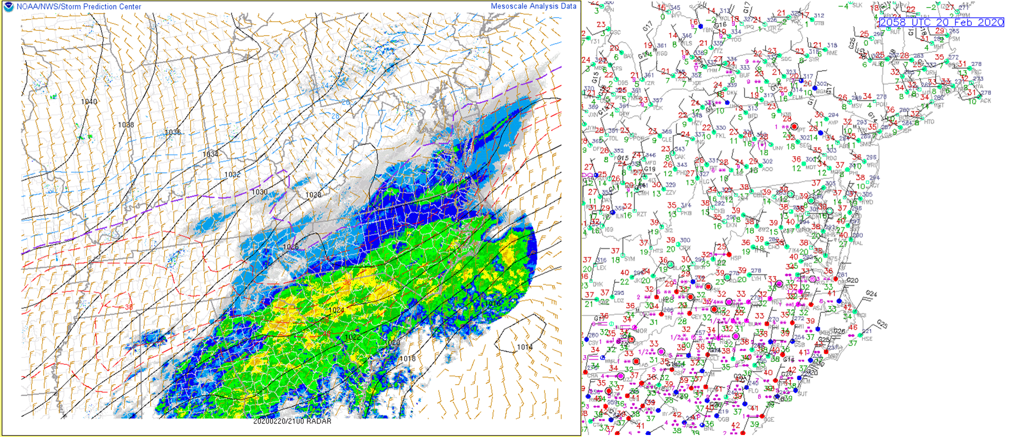 |
| 18z/1 PM MSLP/Wind/Wet Bulb Temperature/Radar/Observations | 21z/4 PM MSLP/Wind/Wet Bulb Temperature/Radar/Observations |
 |
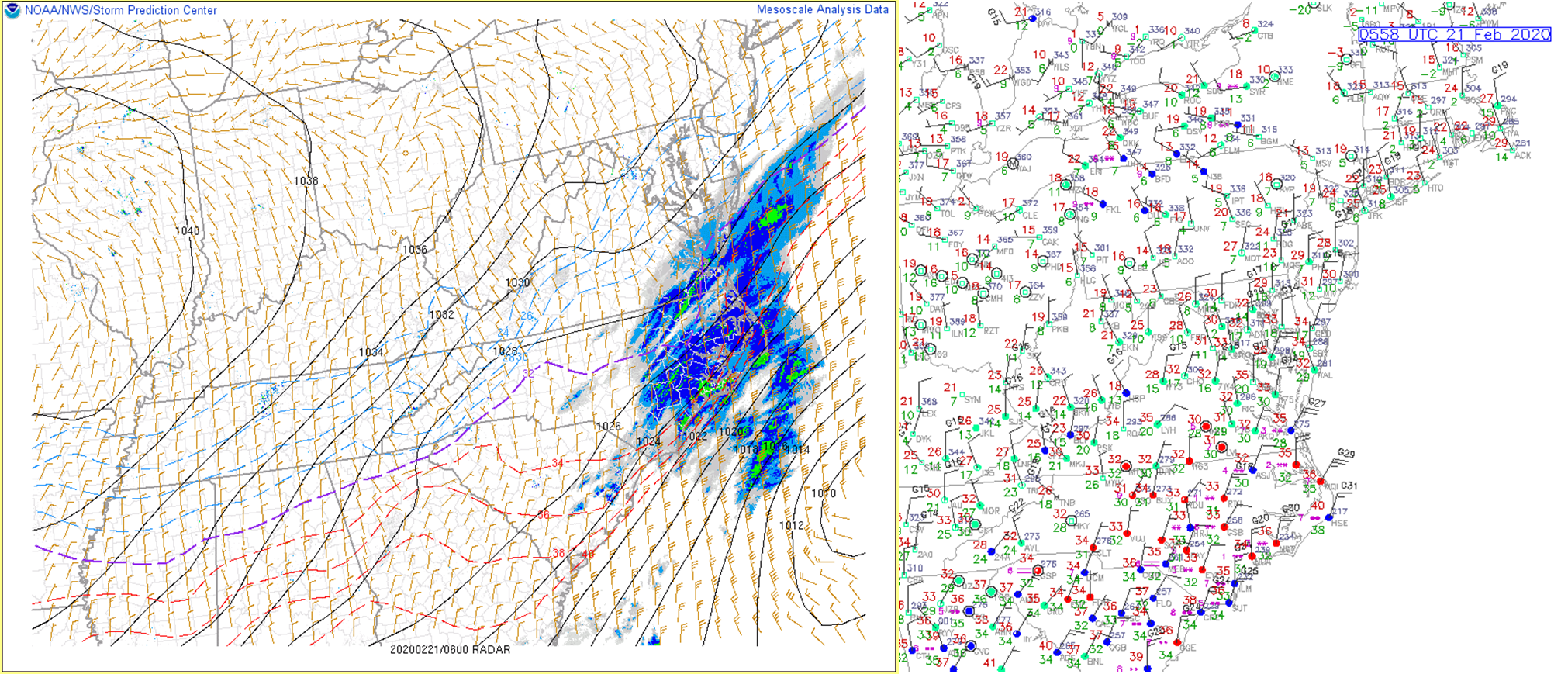 |
| 00z/7 PM MSLP/Wind/Wet Bulb Temperature/Radar/Observations | 06z/1 AM MSLP/Wind/Wet Bulb Temperature/Radar/Observations |
 |
Media use of NWS Web News Stories is encouraged! Please acknowledge the NWS as the source of any news information accessed from this site. |
 |