Overview
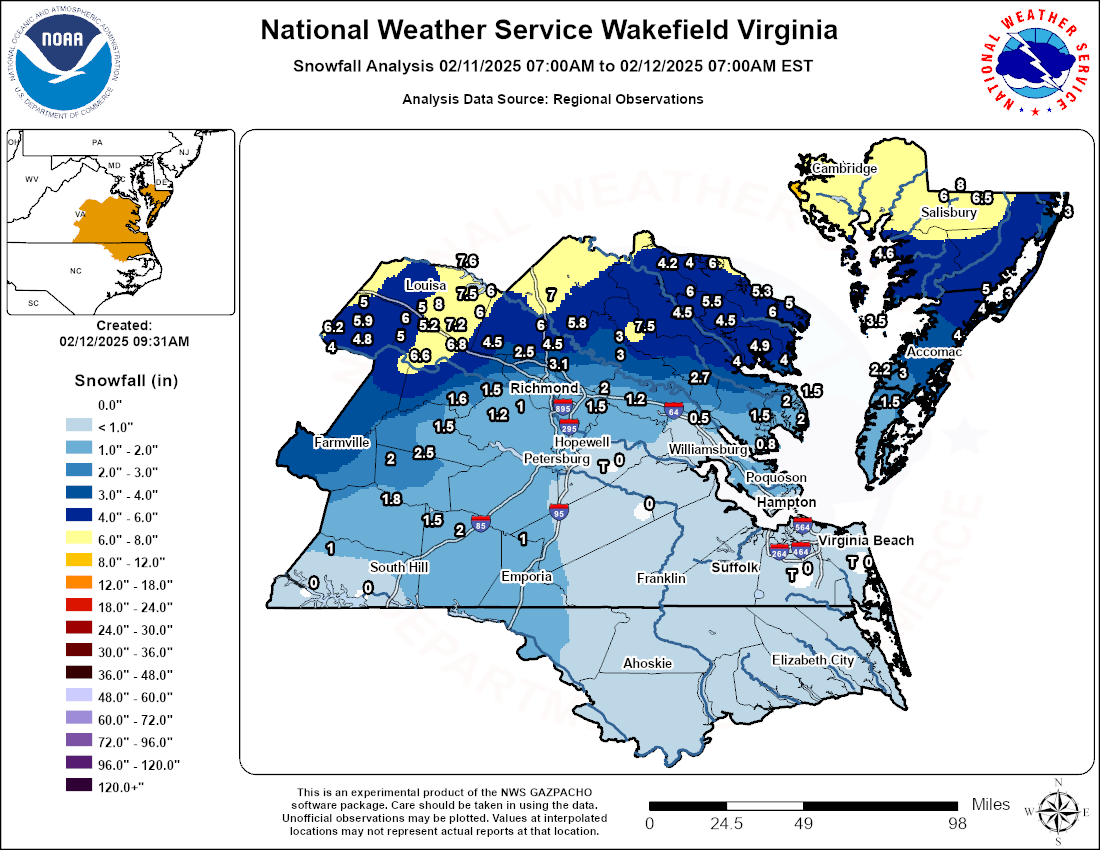
A long duration winter storm impacted the Wakefield CWA from February 11-12, 2025. A series of shortwaves in W to SW flow aloft tracked over the area during this time, bringing several waves of precipitation to the area. The first wave started during the morning of 2/11. A cold (but not unseasonably cold) airmass was in place, so this was primarily in the form of snow, although warm air advection aloft quickly allowed the precipitation to change to rain from the Tri-Cities southward by mid to late morning. However, portions of the centra/south-central VA Piedmont picked up a quick 1-3” of snow (locally up to 4” in Farmville) by noon. A strong (50-60 knot) southerly low level jet around 850-800 mb allowed warmer air aloft to surge north of the Richmond Metro by the afternoon. This LLJ allowed mid-level FGen to increase, which helped the precipitation intensity to also increase. Just to the north of the 850 mb 0°C line, moderate to heavy bands of snow set up from the central VA Piedmont to the Lower Eastern Shore during the afternoon and evening. Widespread 6-8” totals were observed from Louisa, Fluvanna, and Hanover/Caroline Counties over to the MD Eastern Shore. Totals of 3-4” were observed in northern portions of the Richmond Metro area, with little to nothing across eastern Chesterfield County where precipitation changed over to sleet and rain by midday. The snowfall gradient from Chesterfield to Hanover Counties was impressive…with totals going from one half inch to 6-8” in a matter of 50 miles. While the snow caused widespread travel issues, power outages (from the snow alone) were localized at most, possibly due to the lack of wind with this event. However, the snow was arguably NOT the greatest impact from this winter storm.
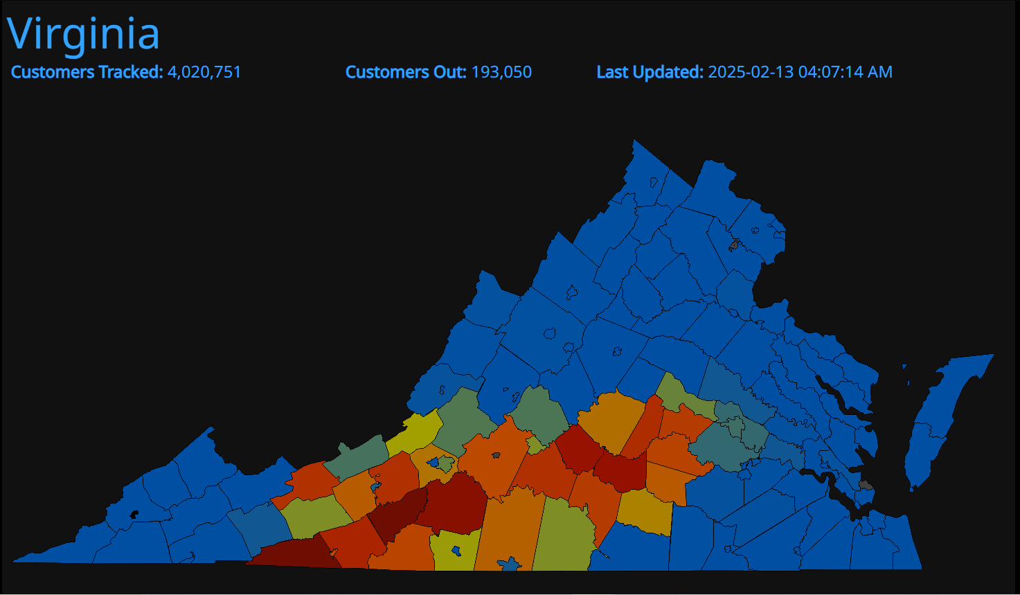
Eventually, precipitation changed over to all liquid by Tuesday night. However, weak low-level cold air advection allowed surface temperatures to drop to 30-31°F from the central VA Piedmont to western portions of the Richmond Metro during the night. With continued light to moderate rain, ice accretion was decently efficient on trees and power lines (especially in the Piedmont) even though there was no ice on area roadways. The weight of the ice (and ice on top of snow) downed several trees and power lines in the Piedmont and Richmond Metro, resulting in widespread power outages across western portions of the Wakefield CWA. Little to no ice was observed from Lunenburg/Dinwiddie Counties south and east as temperatures did not drop lower than 32-33°F. This was a case where 1-2 degrees made the difference between 0.25” of ice on trees/power lines (like what happened in Farmville) and plain rain farther southeast. There were nearly 200,000 power outages in the state of Virginia at the peak of the event. Some areas were without power for 3-5 days.
Snow/Ice Maps
Radar
Selected Radar Loops
 |
 |
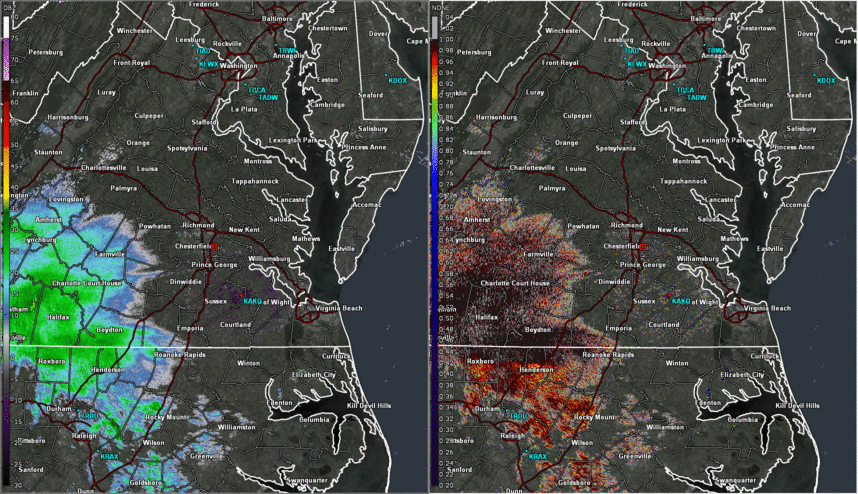
| Radar Loop of 0.5° Reflectivity (left) and Correlation Coefficient (right) from 6 am to 2 pm in 30 minute increments | Radar Loop of 0.5° Reflectivity (left) and Correlation (right) from 2 pm to 2 am in 30 minute increments |
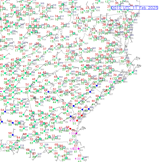 |
| Regional Surface Observations from 7 PM on 2-10 to 7 AM on 2-12 in 1 hour increments |
Storm Reports
Public Information Statement
National Weather Service Wakefield VA
900 AM EST Wed Feb 12 2025

...SNOWFALL REPORTS...

Location                     Amount    Time/Date       Lat/Lon

...Maryland...

...Dorchester County...
Cambridge                    8.0 in    0530 AM 02/12   38.56N/76.07W
1 SE Cambridge               6.0 in    0747 PM 02/11   38.55N/76.06W

...Somerset County...
2 S Deal Island              4.6 in    0700 AM 02/12   38.14N/75.95W

...Wicomico County...
Delmar                       8.0 in    0700 AM 02/12   38.45N/75.57W
2 W Parsonsburg              6.5 in    0827 PM 02/11   38.39N/75.50W
2 N Salisbury                6.0 in    0830 PM 02/11   38.40N/75.59W

...Worcester County...
2 ESE West Ocean City        3.0 in    0638 PM 02/11   38.33N/75.08W

...Virginia...

...Accomack County...
Horntown                     5.0 in    0515 PM 02/11   37.97N/75.46W
4 SSW Modest Town            4.0 in    0700 AM 02/12   37.76N/75.59W
2 NE Atlantic                4.0 in    0713 PM 02/11   37.92N/75.48W
Accomac                      4.0 in    0528 PM 02/11   37.72N/75.67W
Tangier                      3.5 in    0524 PM 02/11   37.83N/75.99W
Harborton                    3.0 in    0510 PM 02/11   37.66N/75.84W
Chincoteague                 3.0 in    0404 PM 02/11   37.95N/75.36W
5 WSW Pungoteague            2.3 in    0300 PM 02/11   37.60N/75.89W

...Amelia County...
Amelia Courthouse            1.5 in    0930 AM 02/11   37.34N/77.98W

...Brunswick County...
Alberta                      2.0 in    1200 PM 02/11   36.86N/77.88W

...Caroline County...
3 SE Golansville             7.0 in    0651 PM 02/11   37.95N/77.46W
1 S Dawn                     5.8 in    0700 AM 02/12   37.82N/77.37W

...Chesterfield County...
1 NNW Midlothian             1.5 in    1215 PM 02/11   37.51N/77.65W
4 NW Beach                   1.3 in    1200 PM 02/11   37.39N/77.65W
3 SE Midlothian              1.0 in    0100 PM 02/11   37.47N/77.61W

...City of Chesapeake County...
3 SSE Herberts Corner         T in     0700 AM 02/12   36.69N/76.28W

...City of Norfolk County...
2 SE Norview                 0.1 in    0700 AM 02/12   36.87N/76.23W

...City of Richmond County...
2 SSE Lakeside               1.0 in    0342 PM 02/11   37.59N/77.46W

...City of Virginia Beach County...
2 NW Sigma                    T in     0700 AM 02/12   36.75N/76.00W

...City of Williamsburg County...
1 ENE Williamsburg           0.5 in    0415 PM 02/11   37.27N/76.69W

...Cumberland County...
1 SSW Pemberton              6.6 in    0548 PM 02/11   37.67N/78.09W

...Essex County...
Dunnsville                   4.5 in    0550 PM 02/11   37.86N/76.82W

...Fluvanna County...
5 SW Antioch                 6.2 in    0624 PM 02/11   37.80N/78.49W
3 SW Cunningham              5.9 in    0220 PM 02/11   37.85N/78.36W
1 SE Lake Monticello         5.0 in    0311 PM 02/11   37.91N/78.32W
2 SW Central Plains          4.8 in    1258 PM 02/11   37.78N/78.36W
Hardware                     4.0 in    0307 PM 02/11   37.74N/78.40W

...Gloucester County...
1 SSW Ware Neck              1.5 in    0700 AM 02/12   37.39N/76.47W
1 S Gloucester Point         0.8 in    0700 AM 02/12   37.26N/76.50W

...Goochland County...
2 SW Orchid                  7.2 in    0700 AM 02/12   37.81N/77.92W
Tabscott                     6.0 in    0526 PM 02/11   37.86N/78.06W
2 NNE Tabscott               5.3 in    0305 PM 02/11   37.88N/78.05W
1 ENE Columbia               5.0 in    0200 PM 02/11   37.76N/78.15W

...Greensville County...
Purdy                        1.0 in    0414 PM 02/11   36.82N/77.59W

...Hanover County...
2 WSW Gum Tree               6.0 in    0600 PM 02/11   37.81N/77.51W
1 SW Ashland                 4.5 in    0700 AM 02/12   37.76N/77.48W
2 S Vontay                   4.5 in    0603 PM 02/11   37.73N/77.76W
2 S Vontay                   3.5 in    0416 PM 02/11   37.73N/77.76W

...Henrico County...
3 N Short Pump               4.0 in    0600 PM 02/11   37.69N/77.61W
1 ENE Longdale               3.1 in    1253 PM 02/11   37.66N/77.46W
3 N Short Pump               3.0 in    0530 PM 02/11   37.69N/77.61W
3 N Short Pump               2.5 in    0130 PM 02/11   37.69N/77.61W
1 WNW Bottoms Bridge         2.0 in    0420 PM 02/11   37.51N/77.21W
1 W Bottoms Bridge           1.5 in    0105 PM 02/11   37.51N/77.21W
1 N Varina                   1.0 in    0309 PM 02/11   37.46N/77.35W

...James City County...
Toano                        0.5 in    0100 PM 02/11   37.38N/76.81W

...King William County...
1 NW Central Garage          3.0 in    0440 PM 02/11   37.75N/77.14W
Central Garage               3.0 in    0352 PM 02/11   37.75N/77.14W
1 N West Point               2.7 in    0700 AM 02/12   37.57N/76.80W

...King and Queen County...
Saint Stephens Church        7.5 in    0737 PM 02/11   37.80N/77.06W

...Lancaster County...
1 SSE Mollusk                4.9 in    0700 AM 02/12   37.71N/76.53W
White Stone                  4.0 in    0517 PM 02/11   37.65N/76.39W

...Louisa County...
1 SE Yanceyville             8.0 in    0558 PM 02/11   37.90N/77.98W
2 NNE Wares Crossroads       7.6 in    0625 AM 02/12   38.10N/77.87W
1 E Cuckoo                   7.5 in    0448 AM 02/12   37.95N/77.87W
3 ENE Gum Spring             6.8 in    0535 PM 02/11   37.80N/77.85W
Bumpass                      6.0 in    0612 PM 02/11   37.97N/77.74W
Locust Creek                 6.0 in    0551 PM 02/11   37.87N/77.79W
3 E Ferncliff                5.0 in    0835 AM 02/12   37.93N/78.06W
2 N Louisa                   4.1 in    0800 AM 02/12   38.04N/78.00W

...Lunenburg County...
1 N Victoria                 1.8 in    1000 AM 02/11   37.01N/78.22W
1 WSW Dundas                 1.5 in    1000 AM 02/11   36.91N/78.03W

...Mathews County...
1 SSE Port Haywood           2.0 in    0700 AM 02/12   37.37N/76.31W
1 SSE North                  2.0 in    0325 PM 02/11   37.46N/76.38W
Gwynn                        1.5 in    0530 PM 02/11   37.50N/76.29W

...Mecklenburg County...
2 SSW Chase City             1.0 in    1000 AM 02/11   36.78N/78.47W
1 E Clarksville               T in     1000 AM 02/11   36.62N/78.55W
John H Kerr Dam               T in     1000 AM 02/11   36.60N/78.30W

...Middlesex County...
Urbanna                      4.0 in    0617 PM 02/11   37.64N/76.57W

...New Kent County...
1 NNW Mountcastle            1.2 in    0348 PM 02/11   37.47N/77.10W

...Northampton County...
3 WNW Birdsnest              1.5 in    0700 AM 02/12   37.45N/75.93W

...Northumberland County...
3 ESE Howland                6.0 in    0700 AM 02/12   37.86N/76.41W
Lottsburg                    5.3 in    0643 PM 02/11   37.96N/76.52W
Edwardsville                 5.0 in    0611 PM 02/11   37.91N/76.36W

...Nottoway County...
1 SSW Fergusonville          2.5 in    0519 PM 02/11   37.22N/78.07W
Burkeville                   2.0 in    0930 AM 02/11   37.19N/78.20W

...Powhatan County...
Genito                       1.6 in    1020 AM 02/11   37.46N/77.86W

...Prince Edward County...
1 NNE Farmville              4.0 in    1200 PM 02/11   37.30N/78.39W

...Prince George County...
4 S Garysville                T in     0700 AM 02/12   37.19N/77.15W

...Richmond County...
Warsaw                       6.0 in    0546 PM 02/11   37.96N/76.76W
Kennard                      5.5 in    0734 PM 02/11   37.92N/76.75W
Emmerton                     4.5 in    0540 PM 02/11   37.90N/76.68W

...Sussex County...
2 NW Wakefield                T in     0700 AM 02/12   36.99N/77.01W

...Westmoreland County...
Mount Holly                  6.0 in    0543 PM 02/11   38.09N/76.72W
1 NW Montross                4.2 in    0621 PM 02/11   38.10N/76.83W
Montross                     4.0 in    0531 PM 02/11   38.09N/76.82W

...FREEZING RAIN REPORTS...

Location                     Amount    Time/Date       Lat/Lon

...Virginia...

...Chesterfield County...
4 NW Beach                   0.10 in   0810 AM 02/12   37.39N/77.65W

...Henrico County...
2 WSW Dumbarton              0.22 in   0554 AM 02/12   37.60N/77.54W
1 NNE Fair Oaks              0.16 in   0815 AM 02/12   37.54N/77.31W
&&
Environment
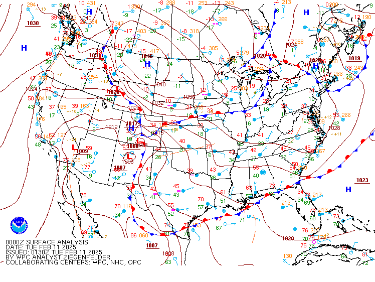
Synoptic summary (and power outages)
 |
 |
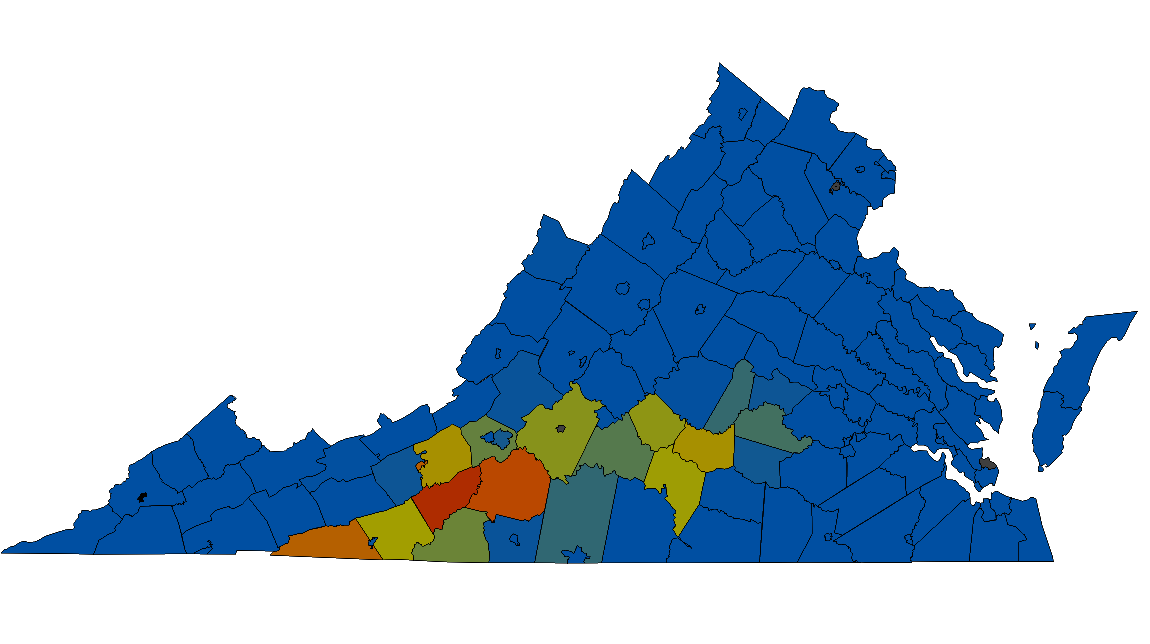 |
| Loop of WPC Surface Analysis from 7 PM on 2/10 to 7 AM on 2-12 | Power Outages on 2-12 (peak of ice event) | Power Outages on 2-15 (3 Days after the event) |
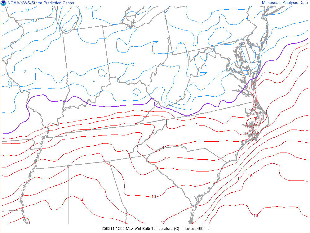
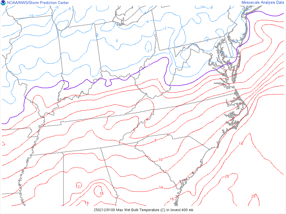
Near-storm environment summary.
 |
 |
 |
 |
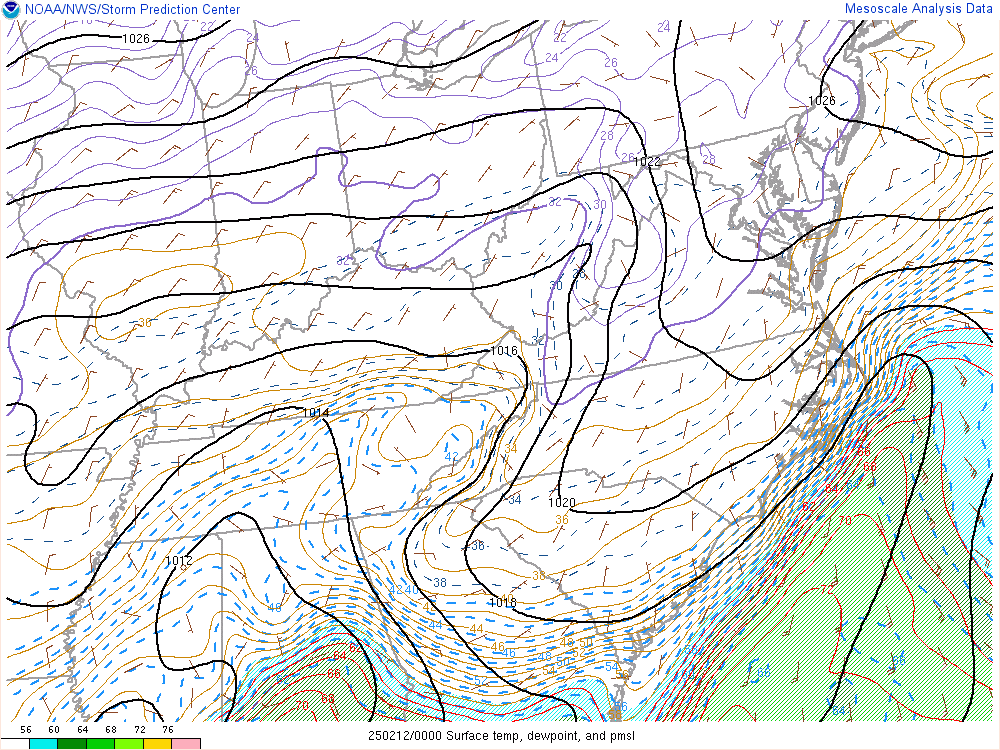
| Loop of sfc-400mb Max Wet Bulb Temperature (C) from 7 AM to 7 PM on 2-11 | Loop of sfc-400mb Max Wet Bulb Temperature (C) from 7 PM on 2-11 to 7 AM on 2-12 | Loop of Temperature/Dew Point/MSLP from 7 PM on 2-11 to 7 AM on 2-12 | Loop of 850mb Frontogenesis from 7 AM to 7 PM on 2-11 |
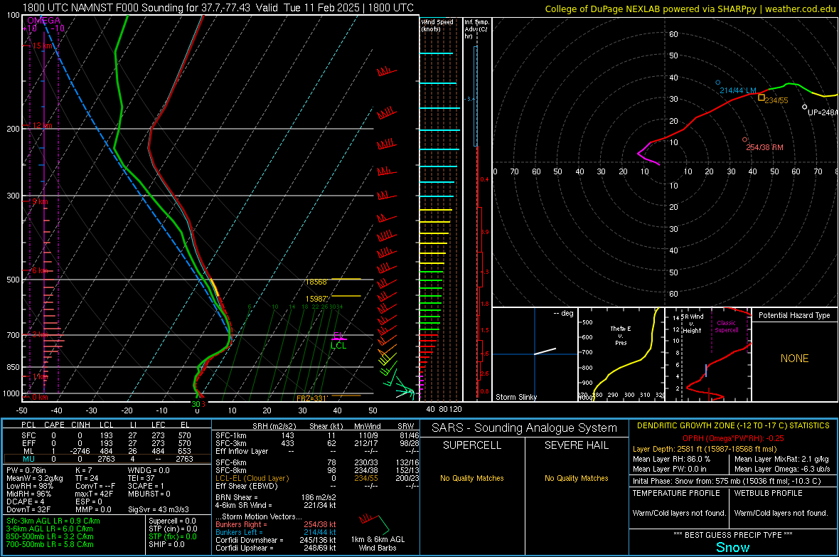
Environmental Sounding data.
 |
 |
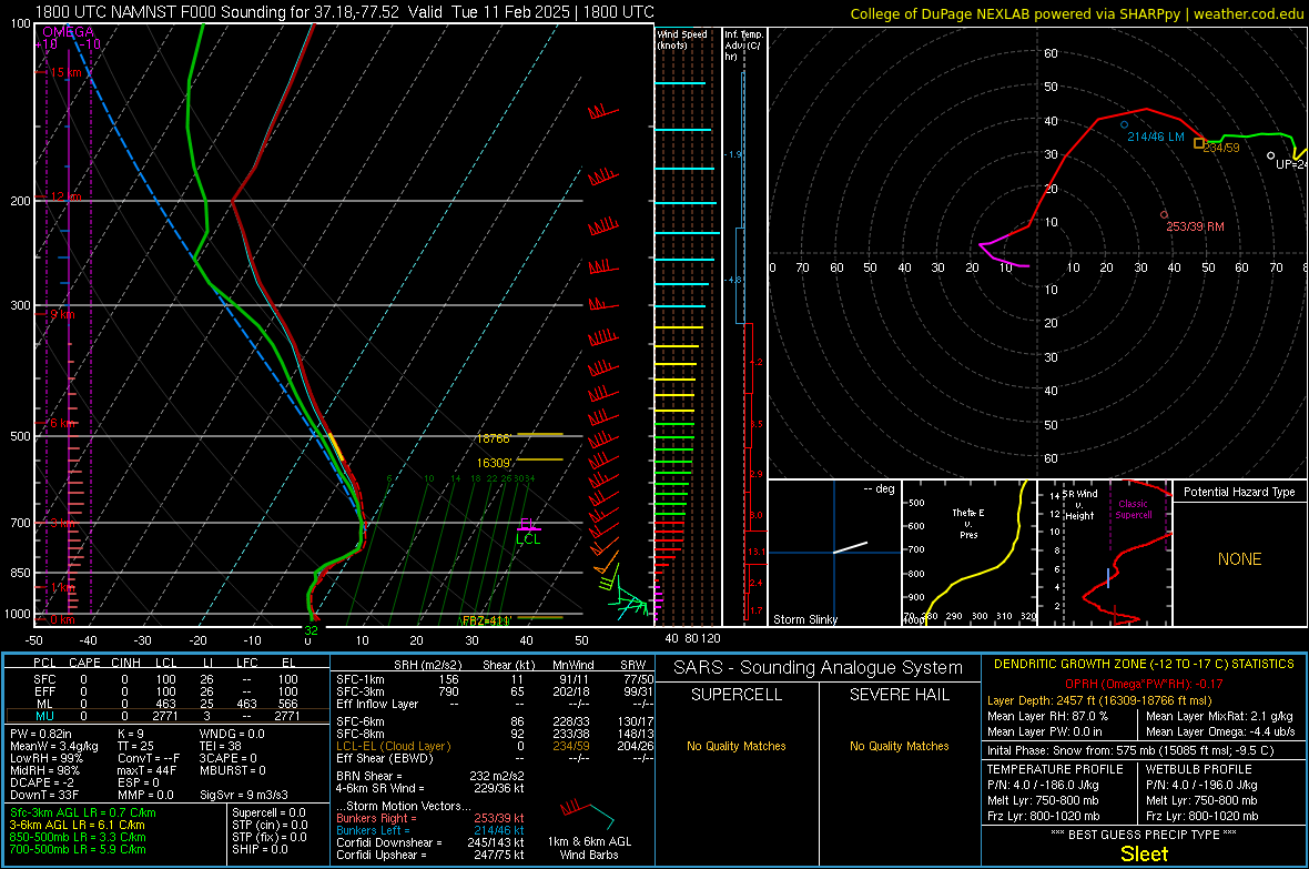 |
| 18z/1 PM OFP NAMNest Analysis Sounding | 18z/1 PM RIC NAMNest Analysis Sounding | 18z/1 PM PTB NAMNest Analysis Sounding |
Environmental sounding data.
 |
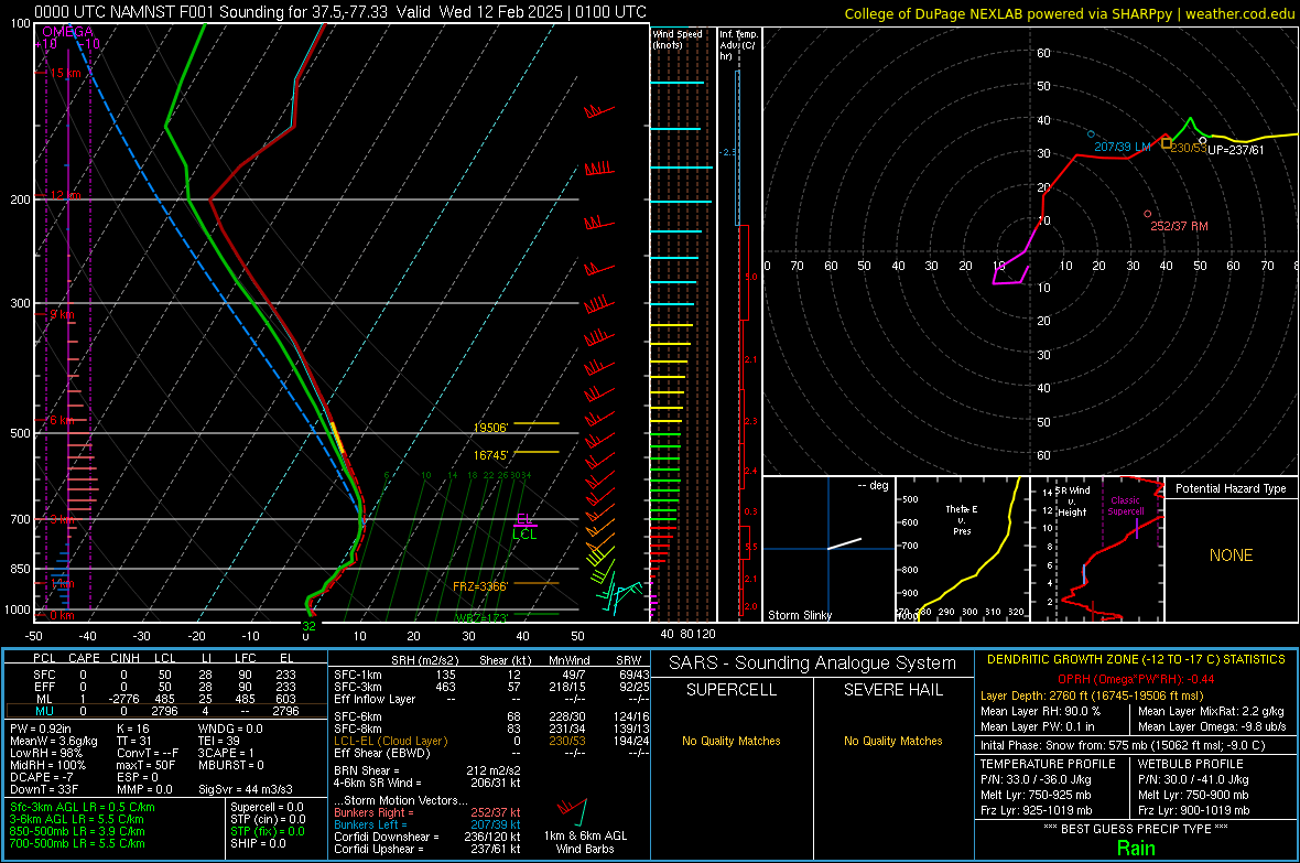 |
| 00z NAMNest 1 hr Forecast Sounding valid at 8 PM on 2-19 for LKU (Louisa,VA) | 00z NAMNest 1 hr Forecast Sounding valid at 8 PM on 2-19 for RIC |
 |
Media use of NWS Web News Stories is encouraged! Please acknowledge the NWS as the source of any news information accessed from this site. |
|


 Coastal Flood
 Heat
Heat