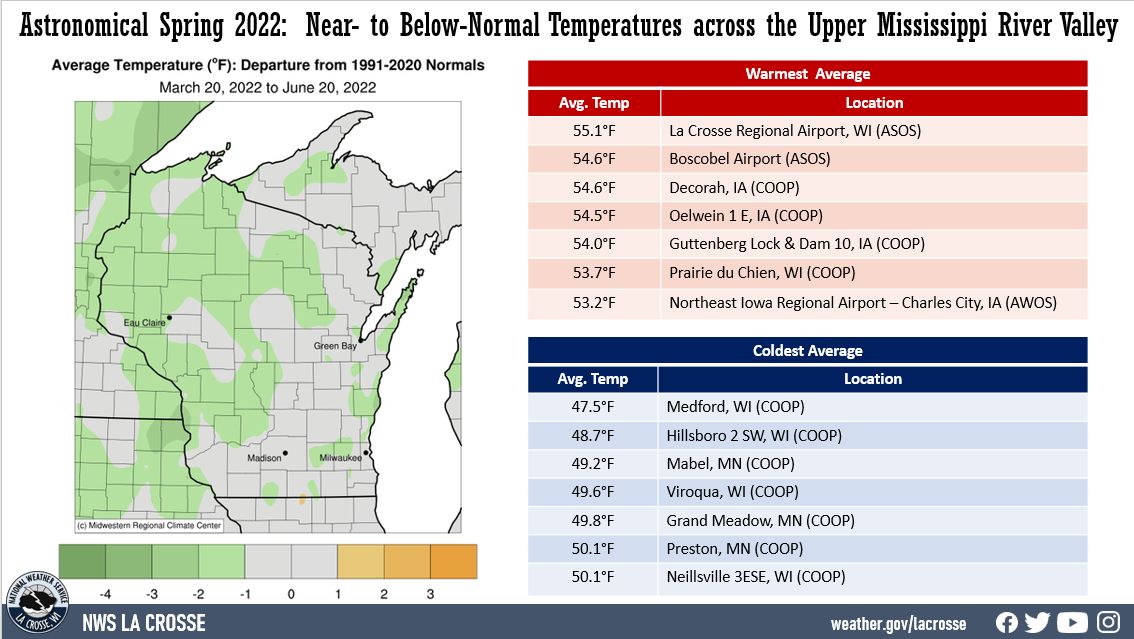
During the astronomical spring of 2022 (March 20-June 20), temperatures ranged from 2°F below normal to near normal across the Upper Mississippi River Valley. Average temperatures ranged from 47.5°F at Medford, WI (COOP) to 55.1°F at La Crosse, WI (ASOS). The coldest temperature was 4°F at Black River Falls and Sparta, WI on March 28 and the hottest temperature was 99°F near Oelwein, IA and Theilman, MN on June 15. This is a 95°F temperature difference.
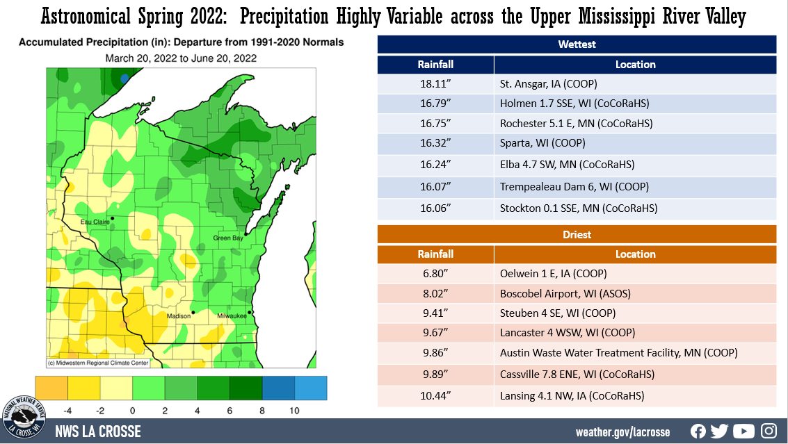
Precipitation anomalies ranged from 4" drier-than-normal to nearly 4.5" wetter-than-normal across the Upper Mississippi River Valley. Precipitation totals ranged from 6.80” near Oelwein, IA (COOP) to 18.11” at St. Ansgar, IA (COOP). The wettest 1-day precipitation was 4.50" at St. Ansgar, IA (COOP). This precipitation fell from 7 AM on April 12 to 7 AM on April 13.
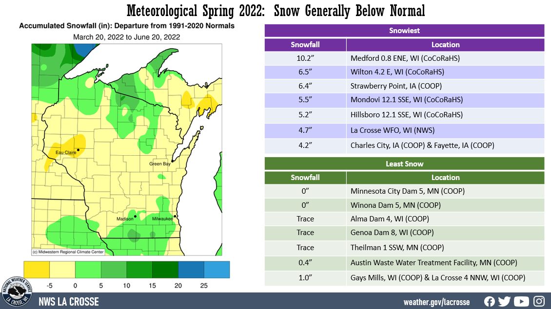
Snowfall anomalies ranged from 10" below-normal to 5" above-normal. Snowfall totals ranged from 0" at Minnesota City Dam 5 and Winona Dam 5 in southeast Minnesota to 10.2" near Medford, WI. The snowiest day was 4" near Mondovi, WI (CoCoRaHS) from 7 AM on March 23 to 7 AM on March 24.
 |
 |
 |
| Temperature Anomalies | Precipitation Anomalies | Snow Anomalies |
Below are the astronomical spring (March 20 through June 20) summary for La Crosse, WI and Rochester, MN.
|
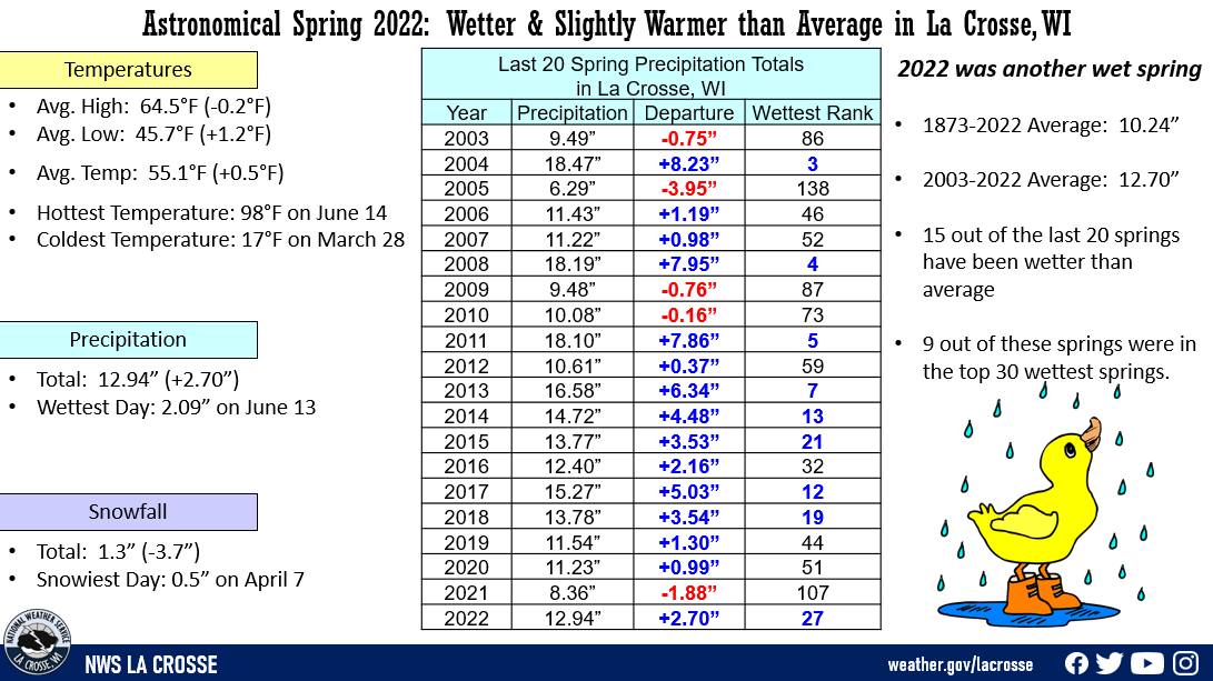
During the astronomical spring of 2022, La Crosse Regional Airport was wetter (12.94" or 2.70" wetter than average) and slightly warmer (55.1°F or 0.5°F warmer than average) than the long-term average (1873-2022). More details on these statistics can be found below. Temperatures - Slightly Warmer than Average From March 20 through June 20, La Crosse Regional Airport had an average temperature of 55.1°F. This was 0.5°F warmer than the long-term average of 54.6°F. This was the coolest since 2020 (64.3°F). This was the 8th consecutive spring to average warmer-than-normal. |
 |
Precipitation - Wetter than Average
From March 20 through June 20, La Crosse Regional Airport received 12.94" of precipitation. This was 2.70" wetter than the long-term average of 10.24". This was the wettest spring since 2018 (13.78" - 19th wettest spring). 15 out of the last 20 springs have been wetter than average. 9 out of these springs (including this year) were among the 30 wettest springs.
Measurable precipitation (0.01" or greater) fell on 25 days (27.2%) and a trace of precipitation fell on 17 days (18.5%).
Number of days with...
The wettest spring day was 2.09" on June 13.
Snowfall - Below Average
From March 20 through June 20, the snow observer near La Crosse Regional Airport measured 1.3" of snow. This was 3.7" below than the long-term average of 5.0".
Measurable snow (0.1" or greater) fell on 4 days (4.3%) and a trace of snow fell on 8 other days (8.6%).
Number of days with...
The snowiest day was 0.5" of snow on April 7.
Snow Depth - Below Average
From March 20 through June 20, the average snow depth near La Crosse Regional Airport was 0". This was 0.1" below the long-term average of 0.1".
The greatest snow depth was 1" on April 8.
Number of days with...
|
During the astronomical spring of 2022, temperatures averaged slightly cooler (51.9°F or 0.3°F cooler than average) and it was the 10th wettest spring (15.15" or 4.80" wetter than average) at Rochester International Airport. More details on these statistics can be found below. Temperatures - Slightly Cooler than Average From March 20 through June 20, Rochester International Airport had an average temperature of 51.9°F. This was 0.3°F cooler than the long-term average of 52.2°F. |
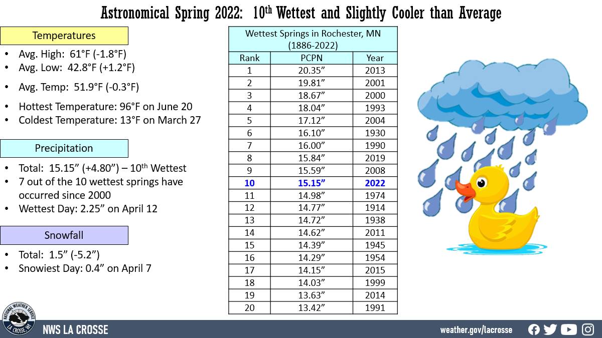 |
Precipitation - 10th Wettest
From March 20 through June 20, Rochester International Airport received 15.15" of precipitation. This was 4.80" wetter than the long-term average of 10.35". This was the 10th wettest spring and the wettest spring since 2019 (15.84" - 8th wettest spring). The wettest spring occurred in 2013 when 20.35" of precipitation fell. 7 out of the 10 wettest springs have occurred since 2000. The table below lists the ten wettest springs.
Wettest Astronomical Springs
in Rochester MN
1886-2021
Precipitation
Rank Total Year
---- ------------- ----
1 20.35 inches 2013
2 19.81 inches 2001
3 18.67 inches 2000
4 18.04 inches 1993
5 17.12 inches 2004
6 16.10 inches 1930
7 16.00 inches 1990
8 15.84 inches 2019
9 15.59 inches 2008
10 15.15 inches 2022
This was in stark contrast to 2021 which was the 5th driest (5.68"). 9 out of the last 10 springs have been wetter than the long-term average. The average precipitation during these years were 13.32".
Measurable precipitation (0.01" or greater) fell on 42 days (45.2%) and a trace of precipitation fell on 15 days (16.1%).
Number of days with...
None 36 days (38.7%)
Trace 15 days (16.1%)
0.01-0.09 inches 18 days (19.4%)
0.10-0.24 inches 10 days (10.8%)
0.25-0.49 inches 4 days ( 4.3%)
0.50-0.99 inches 4 days ( 4.3%)
1.00-1.99 inches 5 days ( 1.9%)
2.00-2.99 inches 1 day ( 1.1%)
The wettest spring day was 2.25" on April 12.
Snowfall - Below Average
From March 20 through June 20, the snow observer near Rochester International Airport measured 1.5" of snow. This was 5.2" below than the long-term average of 6.7 inches.
Measurable snow (0.1" or greater) fell on 7 days (7.5%) and a trace of precipitation fell on 10 days (10.8%).
Number of days with...
The snowiest day was 0.4" on April 7.
Snow Depth - Less than Average
From March 20 through June 20, the average snow depth near Rochester International Airport was 0". This was 0.3" below the long-term average of 0.3".
Number of days with...
The greatest snow depth was 0".


 Weather Story
 Weather Map
 Local Radar