Overview
|
A strong spring weather system brought rounds of thunderstorms to the area on Tuesday, April 12th. Scattered storms produced pea to ping pong sized hail over southern Minnesota into central Wisconsin during the afternoon. More widespread storms impacted the region during the evening and overnight producing hail, damaging winds, a few tornadoes and locally heavy rain. The strongest storms occurred near the Minnesota/Iowa border with storms weakening overnight as they moved into Wisconsin. A total of nine (9) tornadoes have been documented. Other damage has been determined to be wind damage. We are still adding possible tornado damage as we investigate reports and satellite imagery.
|
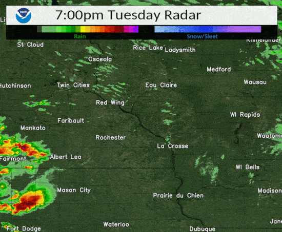
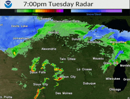 Regional radar animation from 7 pm Apr 12 to 1 am Apr 13 |
Tornadoes:
|
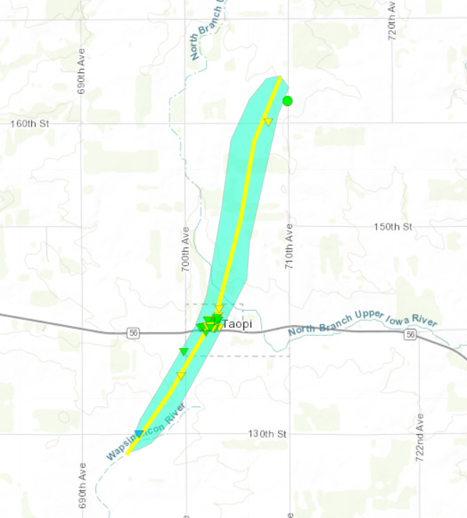
Tornado - TAOPI
|
||||||||||||||||
|
Tornado - COUNTY LINE
|
||||||||||||||||
|
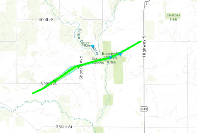
Tornado - BROWNVILLE
|
||||||||||||||||
|
Tornado - RICEVILLE AREA
|
||||||||||||||||
|
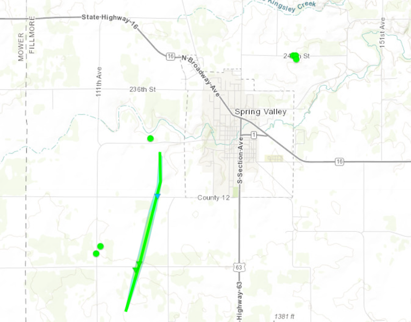
Tornado - SPRING VALLEY
|
||||||||||||||||
|
Tornado - SARATOGA AREA
|
||||||||||||||||
|
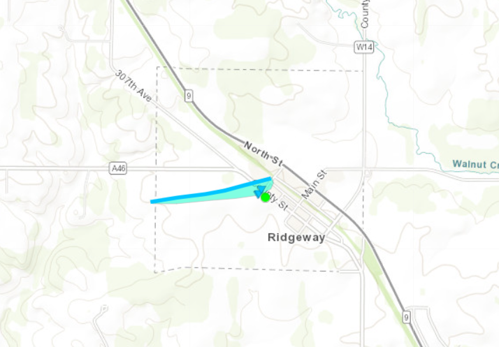
Tornado - RIDGEWAY
|
||||||||||||||||
|
Tornado - SHELTON HILL
|
||||||||||||||||
|
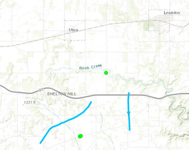
Tornado - RURAL LEWISTON
|
||||||||||||||||
The Enhanced Fujita (EF) Scale classifies tornadoes into the following categories:
| EF0 Weak 65-85 mph |
EF1 Moderate 86-110 mph |
EF2 Significant 111-135 mph |
EF3 Severe 136-165 mph |
EF4 Extreme 166-200 mph |
EF5 Catastrophic 200+ mph |
 |
|||||
Flooding
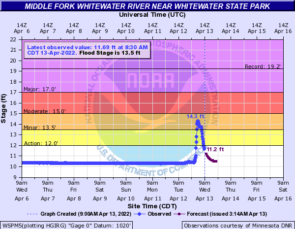
Hydrographs
 |
||
| WSPM5 Hydrograph |
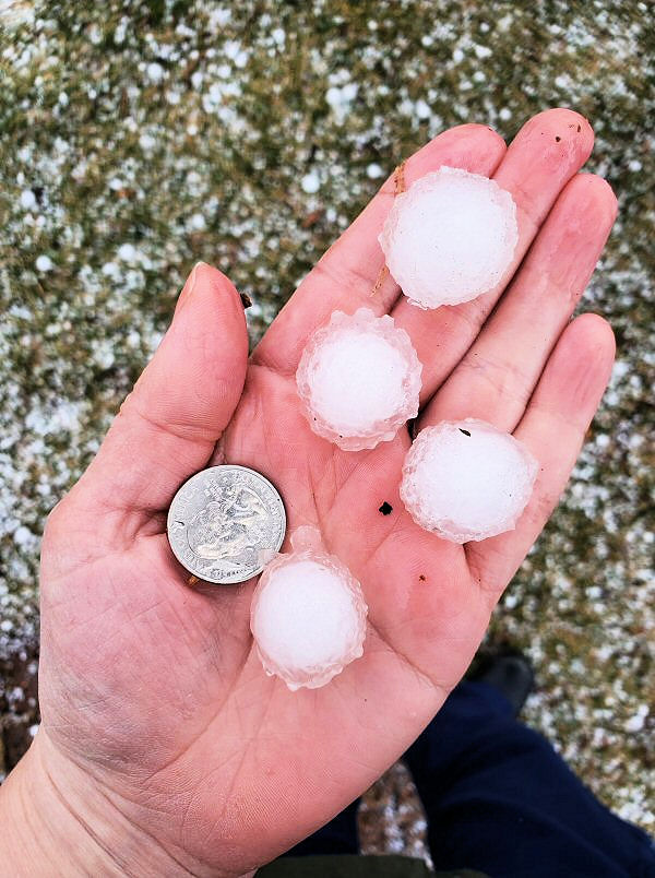
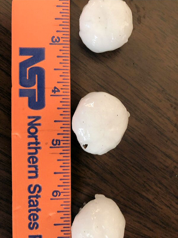
Photos:
 |
 |
 |
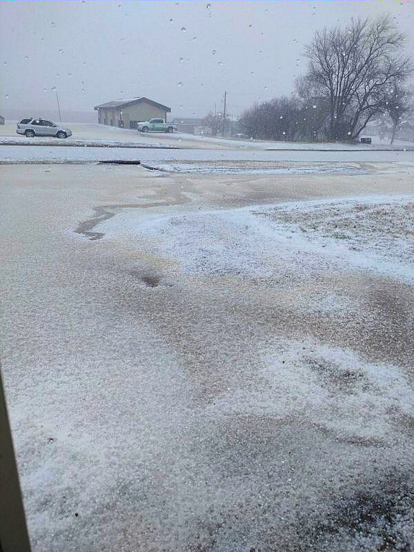 |
| St Charles, MN (Erin Swenson) |
Winona, MN (source) |
Winona, MN (Cheryl Burge) |
Dover, MN (Tony Nelson) |
 |
 |
 |
 |
| Brownville, IA (NWS La Crosse) |
Brownville, IA (NWS La Crosse) |
Riceville, IA (NWS La Crosse) |
Spring Valley, MN (NWS La Crosse) |
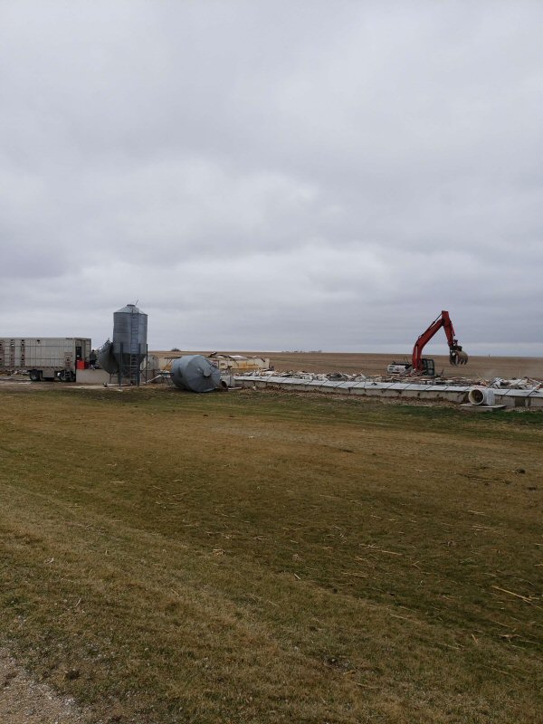
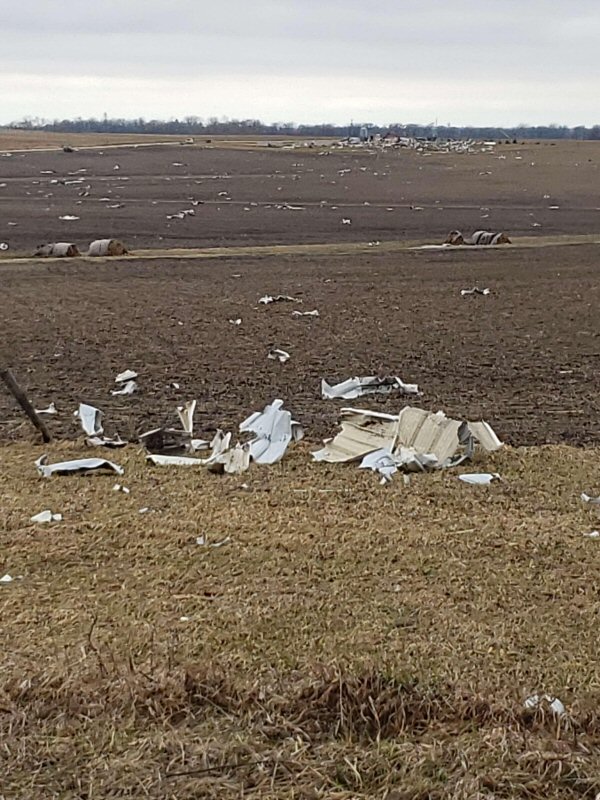
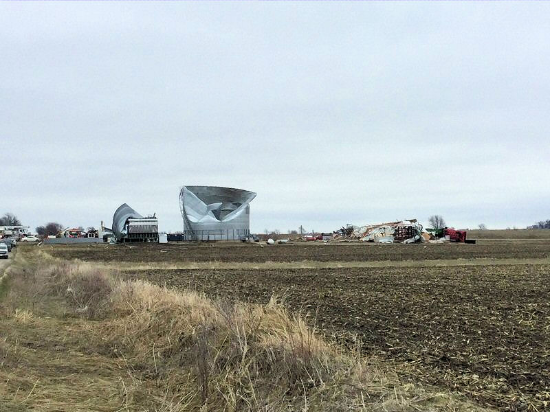
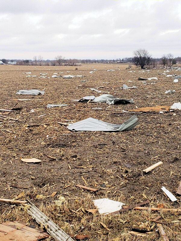
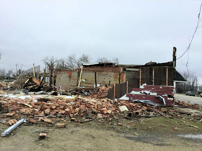
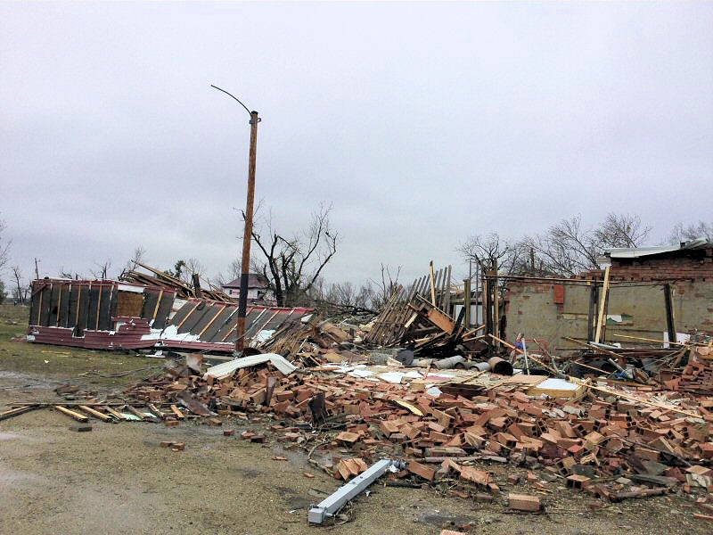
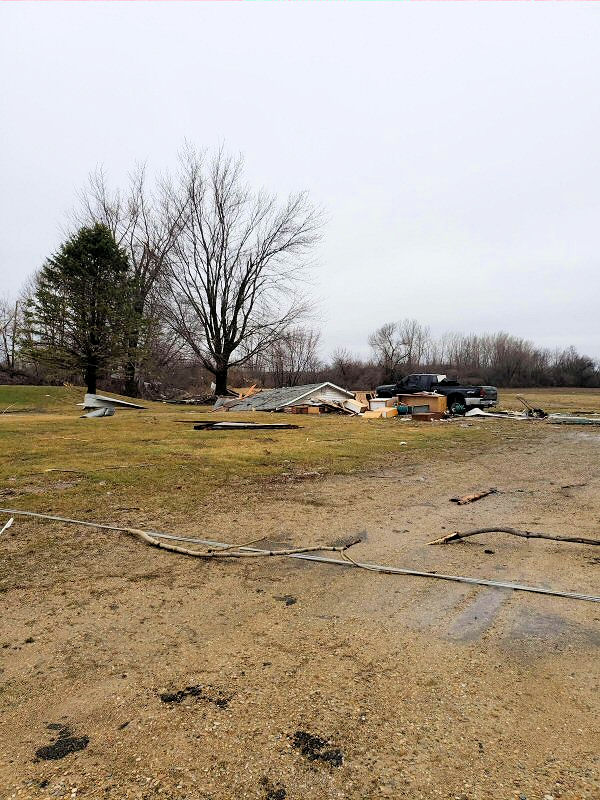
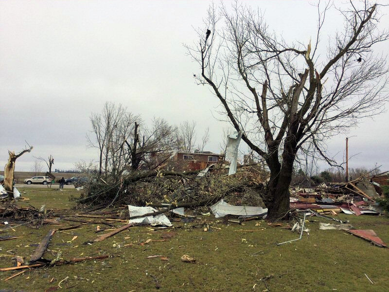
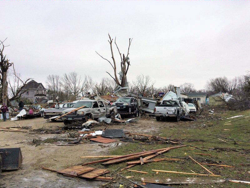
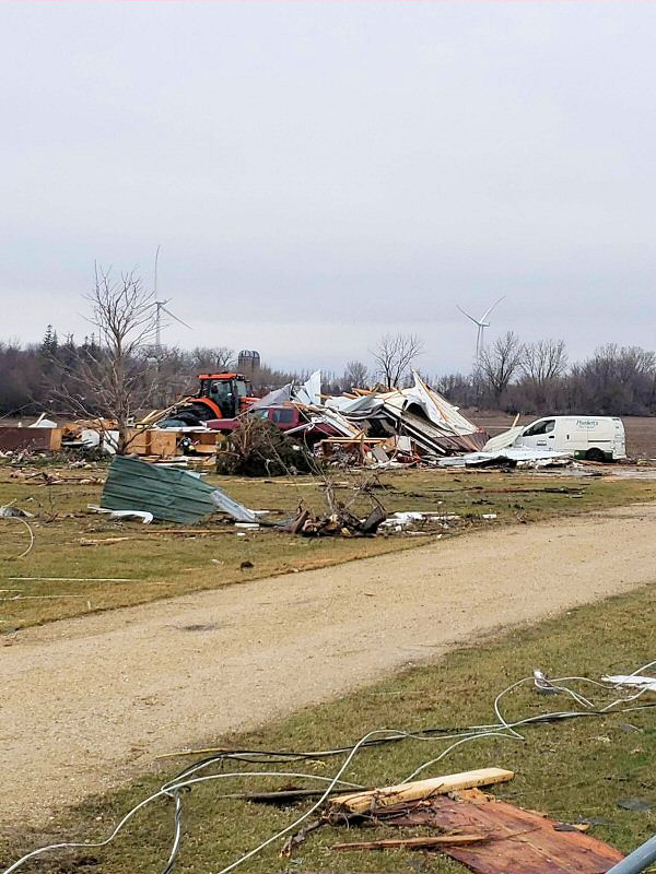
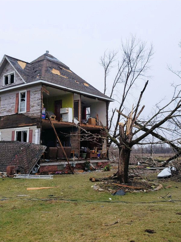
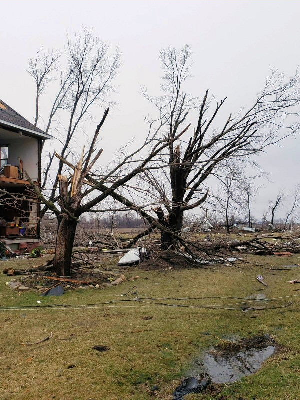
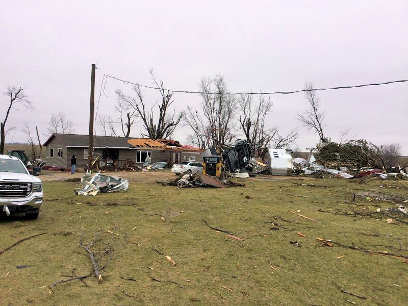
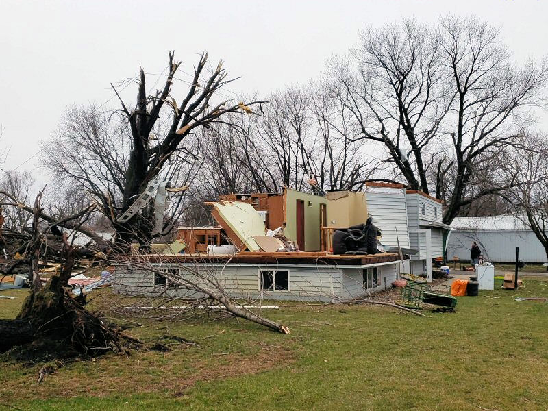
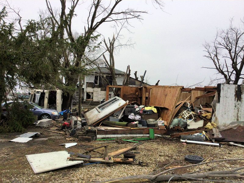
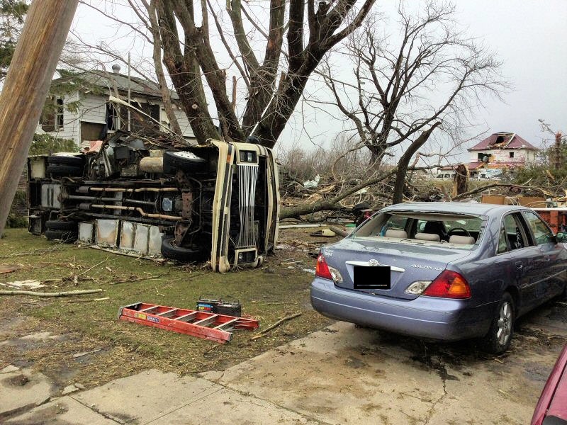
TAOPI, MN -Tornado
 |
 |
 |
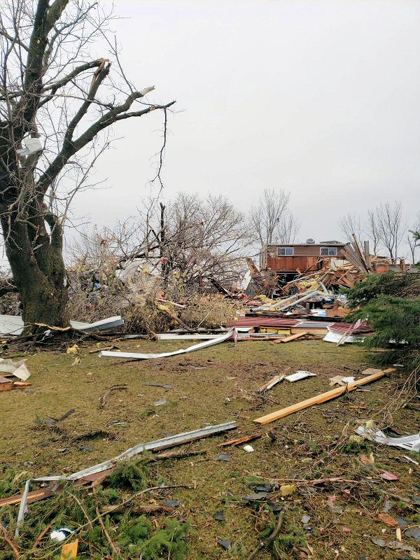 |
| Taopi, MN (NWS La Crosse) |
Taopi, MN (NWS La Crosse) |
Taopi, MN (NWS La Crosse) |
Taopi, MN (NWS La Crosse) |
 |
 |
 |
 |
| Taopi, MN (NWS La Crosse) |
Taopi, MN (NWS La Crosse) |
Taopi, MN (NWS La Crosse) |
Taopi, MN (NWS La Crosse) |
 |
 |
 |
 |
| Taopi, MN (NWS La Crosse) |
Taopi, MN (NWS La Crosse) |
Taopi, MN (NWS La Crosse) |
Taopi, MN (NWS La Crosse) |
 |
|||
| Taopi, MN (NWS La Crosse) |
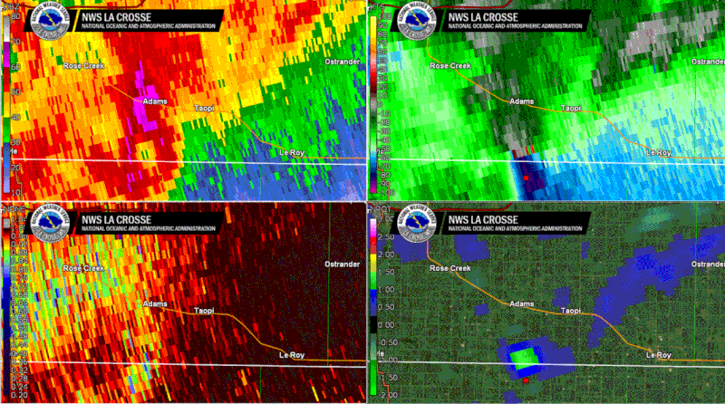
Radar:
 |
 |
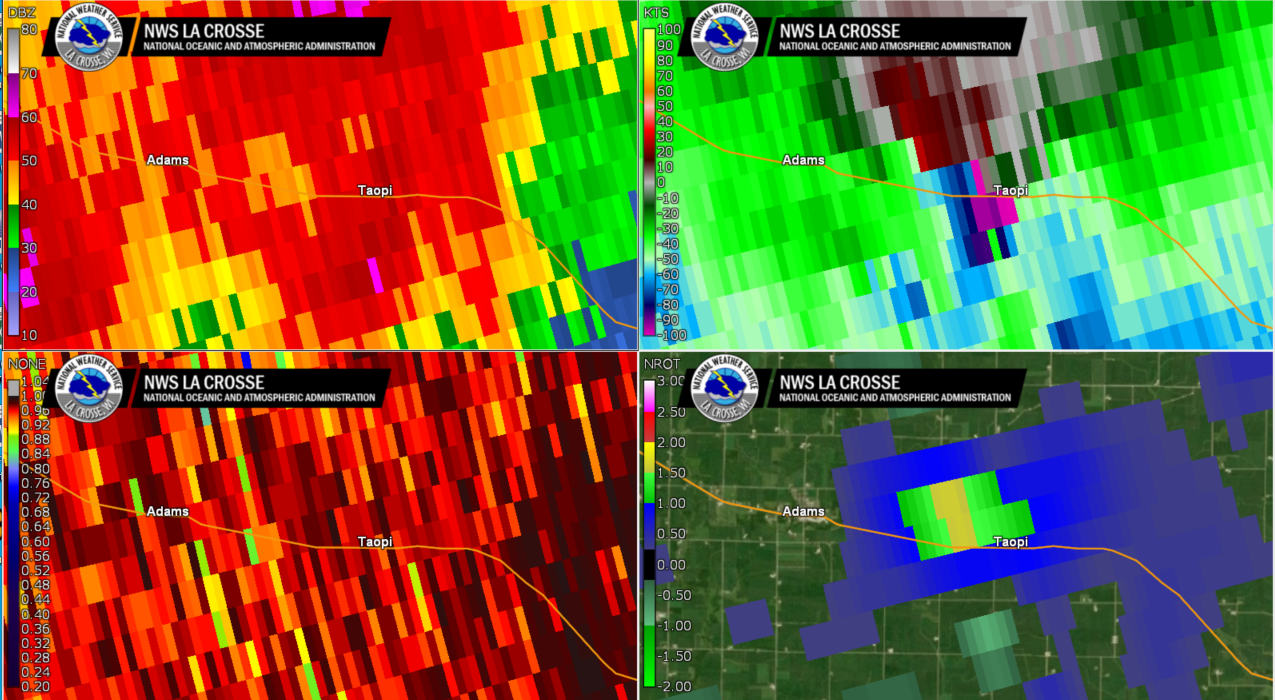 |
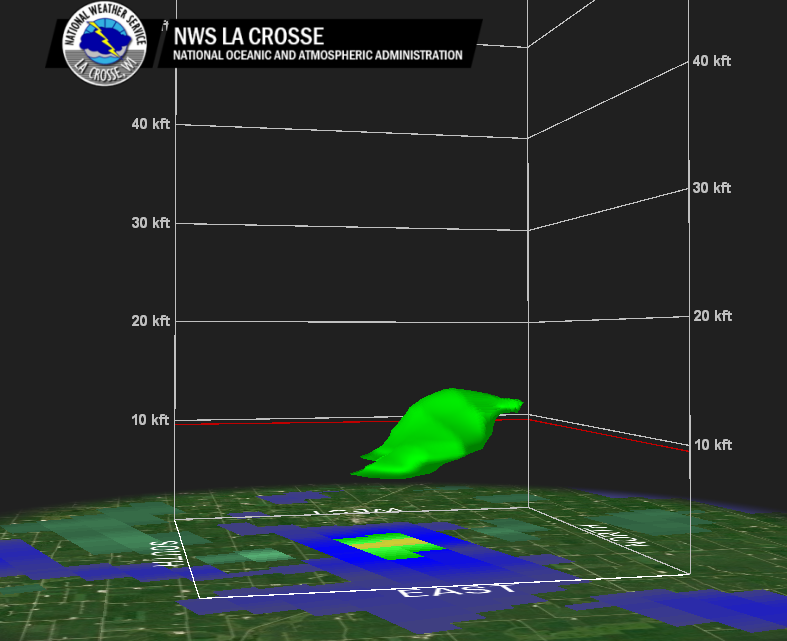 |
| Reflectivity: 7 pm to 1 am | NWS La Crosse radar loop of the Taopi, MN tornadic storm. [Panes, clockwise from upper left: 0.5 Reflectivity, storm-relative velocity, normalized rotation, correlation coefficient] | NWS La Crosse radar image at the time of the Taopi, MN tornado: 1049 pm April 12 2022. [Image panes are the same data as the loop panel to left] | 3-D Normalized rotation from the NWS La Crosse radar at the time of the Taopi, MN tornado: 1049 pm April 12 2022. |
Storm Reports
PRELIMINARY LOCAL STORM REPORT...SUMMARY
NATIONAL WEATHER SERVICE LA CROSSE WI
500 PM CDT TUE APR 12 2022

..TIME...   ...EVENT...      ...CITY LOCATION...     ...LAT.LON...
..DATE...   ....MAG....      ..COUNTY LOCATION..ST.. ...SOURCE....
            ..REMARKS..

0145 PM     HAIL             4 WSW AUSTIN            43.64N 93.05W
04/12/2022  E0.25 INCH       MOWER              MN   PUBLIC


0220 PM     HAIL             STEWARTVILLE            43.85N 92.49W
04/12/2022  U0.50 INCH       OLMSTED            MN   PUBLIC

            REPORT FROM MPING: HALF-INCH (0.50 IN.).

0224 PM     HAIL             3 NW ROCHESTER          44.06N 92.51W
04/12/2022  U0.50 INCH       OLMSTED            MN   PUBLIC

            REPORT FROM MPING: HALF-INCH (0.50 IN.).

0227 PM     HAIL             4 N ROCHESTER           44.06N 92.48W
04/12/2022  U0.75 INCH       OLMSTED            MN   PUBLIC

            REPORT FROM MPING: DIME (0.75 IN.).

0228 PM     HAIL             3 SE ROCHESTER          43.98N 92.44W
04/12/2022  M0.25 INCH       OLMSTED            MN   PUBLIC


0245 PM     HAIL             2 S DOVER               43.95N 92.13W
04/12/2022  E0.25 INCH       OLMSTED            MN   PUBLIC


0250 PM     HAIL             SAINT CHARLES           43.97N 92.06W
04/12/2022  E0.50 INCH       WINONA             MN   EMERGENCY MNGR

            35 MPH WIND GUST.

0254 PM     HAIL             LEWISTON                43.99N 91.87W
04/12/2022  E0.50 INCH       WINONA             MN   TRAINED SPOTTER


0254 PM     HAIL             LEWISTON                43.99N 91.87W
04/12/2022  M1.00 INCH       WINONA             MN   TRAINED SPOTTER


0258 PM     HAIL             ROLLINGSTONE            44.10N 91.82W
04/12/2022  U1.00 INCH       WINONA             MN   PUBLIC

            REPORT FROM MPING: QUARTER (1.00 IN.).


0300 PM     HAIL             GOODVIEW                44.07N 91.71W
04/12/2022  E0.25 INCH       WINONA             MN   LAW ENFORCEMENT
0300 PM     HAIL             2 NNW WILSON            43.98N 91.71W
04/12/2022  M0.88 INCH       WINONA             MN   TRAINED SPOTTER

            45 MPH WIND GUSTS AND DIME TO NICKEL SIZE
            HAIL.
0306 PM     HAIL             WINONA                  44.05N 91.66W
04/12/2022  E0.50 INCH       WINONA             MN   EMERGENCY MNGR


0306 PM     HAIL             1 E WINONA              44.05N 91.64W
04/12/2022  U1.00 INCH       WINONA             MN   PUBLIC

            REPORT FROM MPING: QUARTER (1.00 IN.).


0309 PM     HAIL             3 SE WINONA             44.03N 91.61W
04/12/2022  U0.50 INCH       WINONA             MN   PUBLIC

            REPORT FROM MPING: HALF-INCH (0.50 IN.).


0310 PM     HAIL             1 NW WINONA             44.05N 91.67W
04/12/2022  E0.88 INCH       WINONA             MN   PUBLIC


0311 PM     HAIL             2 SE WINONA             44.02N 91.63W
04/12/2022  U0.75 INCH       WINONA             MN   PUBLIC

            REPORT FROM MPING: DIME (0.75 IN.).


0320 PM     HAIL             WINONA                  44.05N 91.66W
04/12/2022  M0.75 INCH       WINONA             MN   TRAINED SPOTTER

            HAIL COVERING THE GROUND. RANGED FROM PEA TO
            3/4 INCH. LASTED FOR 4 MINUTES.


0321 PM     HAIL             1 NW TREMPEALEAU        44.01N 91.44W
04/12/2022  U0.50 INCH       TREMPEALEAU        WI   PUBLIC

            REPORT FROM MPING: HALF-INCH (0.50 IN.).


0328 PM     HAIL             GALESVILLE              44.09N 91.36W
04/12/2022  E1.00 INCH       TREMPEALEAU        WI   LAW ENFORCEMENT


0328 PM     HAIL             TREMPEALEAU             44.01N 91.44W
04/12/2022  U0.75 INCH       TREMPEALEAU        WI   PUBLIC

            REPORT FROM MPING: DIME (0.75 IN.).


0333 PM     TSTM WND GST     2 E ONALASKA            43.89N 91.18W
04/12/2022  M55 MPH          LA CROSSE          WI   NWS EMPLOYEE


0348 PM     HAIL             1 W HIXTON              44.38N 91.03W
04/12/2022  M0.25 INCH       JACKSON            WI   PUBLIC


0353 PM     HAIL             3 NE CATARACT           44.12N 90.80W
04/12/2022  E1.00 INCH       MONROE             WI   TRAINED SPOTTER


0358 PM     TSTM WND GST     4 ENE SPARTA            43.96N 90.73W
04/12/2022  M46 MPH          MONROE             WI   AWOS


0402 PM     HAIL             4 W WARRENS             44.14N 90.58W
04/12/2022  E1.50 INCH       MONROE             WI   PUBLIC


0410 PM     HAIL             1 N WARRENS             44.15N 90.50W
04/12/2022  E0.75 INCH       MONROE             WI   LAW ENFORCEMENT
0432 PM     HAIL             4 WNW MONROE CENTER     44.15N 90.02W
04/12/2022  M1.00 INCH       JUNEAU             WI   EMERGENCY MNGR


0441 PM     HAIL             NEW ROME                44.24N 89.88W
04/12/2022  M1.00 INCH       ADAMS              WI   TRAINED SPOTTER


0446 PM     TSTM WND DMG     NECEDAH                 44.03N 90.08W
04/12/2022                   JUNEAU             WI   EMERGENCY MNGR

            TREES DOWNED AND BLOCKING ROAD.
0448 PM     TSTM WND GST     1 WNW NECEDAH           44.03N 90.08W
04/12/2022  M52 MPH          JUNEAU             WI   MESONET

            MESONET STATION NEHW3 NECEDAH.
0807 PM     HAIL             LE ROY                  43.51N 92.51W
04/12/2022  M0.75 INCH       MOWER              MN   FIRE DEPT/RESCUE
0900 PM     TSTM WND GST     NORA SPRINGS            43.14N 93.01W
04/12/2022  M72 MPH          FLOYD              IA   FIRE DEPT/RESCUE
1000 PM     HEAVY RAIN       SAINT ANSGAR            43.38N 92.92W
04/12/2022  M2.64 INCH       MITCHELL           IA   PUBLIC
1012 PM     HAIL             1 E OSTRANDER           43.61N 92.41W
04/12/2022  M1.00 INCH       FILLMORE           MN   TRAINED SPOTTER


1012 PM     HAIL             SPRING VALLEY           43.69N 92.39W
04/12/2022  E0.25 INCH       FILLMORE           MN   911 CALL CENTER
1028 PM     HAIL             SPRING VALLEY           43.69N 92.39W
04/12/2022  M0.25 INCH       FILLMORE           MN   TRAINED SPOTTER
1042 PM     HAIL             TAOPI                   43.56N 92.64W
04/12/2022  E1.00 INCH       MOWER              MN   BROADCAST MEDIA


1032 PM     HAIL             WYKOFF                  43.71N 92.27W
04/12/2022  E0.25 INCH       FILLMORE           MN   BROADCAST MEDIA
1042 AM     HEAVY RAIN       3 W MONA                43.49N 93.00W
04/13/2022  E5.10 INCH       MITCHELL           IA   PUBLIC

            RELAYED VIA BROADCAST MEDIA.
1048 PM     TSTM WND DMG     1 SW TAOPI              43.55N 92.65W
04/12/2022                   MOWER              MN   LAW ENFORCEMENT

            ROOF DAMAGE TO RESIDENCE JUST SOUTHWEST OF TOWN. POSSIBLE
            TORNADO.
1048 PM     TSTM WND DMG     TAOPI                   43.56N 92.64W
04/12/2022                   MOWER              MN   911 CALL CENTER

            ANOTHER REPORT OF HOME DAMAGE IN TOWN
1048 PM     TSTM WND DMG     TAOPI                   43.56N 92.64W
04/12/2022                   MOWER              MN   LAW ENFORCEMENT

            *** 2 INJ ***
            HOUSE SLID OFF FOUNDATION, ROOFS OFF HOUSES
            IN AND AROUND TOWN. GRAIN BINS DESTROYED.
            HIGH TRANSMISSION POWER LINES SNAPPED.
            DAMAGE TRACK SEVERAL MILES LONG GOES THROUGH
            THE WESTERN SIDE OF TOWN. HIGH LIKELIHOOD OF
            A TORNADO.
1055 PM     TSTM WND GST     5 SE DECORAH            43.27N 91.72W
04/12/2022  M46 MPH          WINNESHIEK         IA   AWOS

            AWOS STATION KDEH DECORAH MUNICIPAL AIRPORT.
1100 PM     TSTM WND DMG     2 SW SPRING VALLEY      43.66N 92.42W
04/12/2022                   FILLMORE           MN   PUBLIC

            BARN DOWN.
1105 PM     TSTM WND GST     CHARLES CITY            43.07N 92.68W
04/12/2022  E60 MPH          FLOYD              IA   FIRE DEPT/RESCUE

            AT FIRE STATION
1109 PM     TSTM WND GST     2 SW SPRING VALLEY      43.67N 92.42W
04/12/2022  E60 MPH          FILLMORE           MN   TRAINED SPOTTER
1109 PM     TSTM WND DMG     1 SW SPRING VALLEY      43.68N 92.40W
04/12/2022                   FILLMORE           MN   TRAINED SPOTTER

            POWER POLES BLOWN DOWN
1115 PM     TSTM WND GST     3 E CHARLES CITY        43.07N 92.62W
04/12/2022  M64 MPH          FLOYD              IA   AWOS

            AWOS STATION KCCY CHARLES CITY AIRPORT.
1120 PM     TSTM WND GST     2 N IONIA               43.07N 92.46W
04/12/2022  M55 MPH          CHICKASAW          IA   MESONET

            MESONET STATION RNHI4 2 N IONIA.
1136 PM     TSTM WND DMG     RIDGEWAY                43.30N 91.99W
04/12/2022                   WINNESHIEK         IA   LAW ENFORCEMENT

            OUTBUILDINGS DAMAGED.


1134 PM     TSTM WND GST     BLUFFTON                43.40N 91.93W
04/12/2022  E62 MPH          WINNESHIEK         IA   LAW ENFORCEMENT
1136 PM     TSTM WND DMG     3 WSW FREMONT           43.90N 91.95W
04/12/2022                   WINONA             MN   EMERGENCY MNGR

            DAMAGE TO TREES, POWER LINES AND
            OUTBUILDINGS DOWN FROM NEAR FREMONT TO
            LEWISTON, MN.


1140 PM     TSTM WND DMG     2 NNW WILSON            43.98N 91.71W
04/12/2022                   WINONA             MN   TRAINED SPOTTER

            MEASURED 52 MPH GUST. TREE DAMAGE CAUSED
            POWER OUTAGE.
1147 PM     TSTM WND DMG     2 W WINONA              44.05N 91.70W
04/12/2022                   WINONA             MN   EMERGENCY MNGR

            TREES AND POWER LINE DAMAGE
1159 PM     HAIL             HAWKEYE                 42.94N 91.95W
04/12/2022  E0.75 INCH       FAYETTE            IA   FIRE DEPT/RESCUE
1250 AM     TSTM WND DMG     TOMAH                   43.99N 90.50W
04/13/2022                   MONROE             WI   PUBLIC

            ROOF BLOWN OFF BARN.
1255 AM     TSTM WND GST     GUTTENBERG              42.79N 91.11W
04/13/2022  M52 MPH          CLAYTON            IA   TRAINED SPOTTER
0630 AM     HEAVY RAIN       SAINT ANSGAR            43.38N 92.92W
04/13/2022  M4.50 INCH       MITCHELL           IA   CO-OP OBSERVER

            CO-OP OBSERVER STATION SANI4 ST ANSGAR.


0750 AM     HEAVY RAIN       3 SW CUMMINGSVILLE      43.85N 92.30W
04/13/2022  E3.20 INCH       OLMSTED            MN   PUBLIC


0600 AM     HEAVY RAIN       GRAND MEADOW            43.71N 92.56W
04/13/2022  M3.05 INCH       MOWER              MN   CO-OP OBSERVER

            CO-OP OBSERVER STATION GMDM5 GRAND MEADOW.


0945 AM     HEAVY RAIN       SAINT ANSGAR            43.38N 92.92W
04/13/2022  M2.83 INCH       MITCHELL           IA   MESONET

            MESONET STATION CW1238 ST.ANSGAR.


0700 AM     HEAVY RAIN       5 E RACINE              43.78N 92.39W
04/13/2022  M2.78 INCH       FILLMORE           MN   COCORAHS

            COCORAHS STATION MN-FM-19 6 N SPRING VALLEY.


0400 AM     HEAVY RAIN       4 E STEWARTVILLE        43.86N 92.40W
04/13/2022  M2.70 INCH       OLMSTED            MN   COCORAHS

            COCORAHS STATION MN-OL-50 STEWARTVILLE 4.3
            E.


0700 AM     HEAVY RAIN       1 ENE LANSING           43.75N 92.96W
04/13/2022  M2.52 INCH       MOWER              MN   MESONET

            MESONET STATION LANM5 LANSING - CEDAR RIVER.


0623 AM     HEAVY RAIN       2 W CHESTER             44.00N 92.38W
04/13/2022  M2.43 INCH       OLMSTED            MN   COCORAHS

            COCORAHS STATION MN-OL-29 1 W CHESTER.


0630 AM     HEAVY RAIN       ELGIN                   44.13N 92.26W
04/13/2022  M2.40 INCH       WABASHA            MN   COCORAHS

            COCORAHS STATION MN-WB-12 ELGIN 0.4 WNW.


0854 AM     HEAVY RAIN       3 NNW STEWARTVILLE      43.90N 92.50W
04/13/2022  M2.41 INCH       OLMSTED            MN   ASOS

            ASOS STATION KRST ROCHESTER INTERNATIONAL
            AIRPORT.


0700 AM     HEAVY RAIN       2 WNW HIGH FOREST       43.85N 92.59W
04/13/2022  M2.39 INCH       OLMSTED            MN   COCORAHS

            COCORAHS STATION MN-OL-27 2 W HIGH FOREST.


0700 AM     HEAVY RAIN       5 N STEWARTVILLE        43.93N 92.48W
04/13/2022  M2.38 INCH       OLMSTED            MN   CO-OP OBSERVER

            CO-OP OBSERVER STATION RSRM5 ROCHESTER AP
            2NE.


0700 AM     HEAVY RAIN       5 N STEWARTVILLE        43.93N 92.47W
04/13/2022  M2.32 INCH       OLMSTED            MN   COCORAHS

            COCORAHS STATION MN-OL-62 ROCHESTER 5.6 S.


0922 AM     HEAVY RAIN       NELSON                  44.42N 92.01W
04/13/2022  M2.25 INCH       BUFFALO            WI   PUBLIC


0700 AM     HEAVY RAIN       2 SSW ELBA              44.06N 92.04W
04/13/2022  M2.05 INCH       WINONA             MN   CO-OP OBSERVER

            CO-OP OBSERVER STATION ALTM5 ALTURA 5W.


0950 AM     HEAVY RAIN       1 NNW WESTBORO          45.37N 90.31W
04/13/2022  M2.02 INCH       TAYLOR             WI   MESONET

            MESONET STATION FW9268 WESTBORO.
0815 AM     HEAVY RAIN       2 N CARPENTER           43.44N 93.01W
04/13/2022  M4.98 INCH       MITCHELL           IA   PUBLIC
Rain Reports
...PRECIPITATION REPORTS THE PAST 24 HOURS...

LOCATION                     AMOUNT    TIME/DATE       LAT/LON

...IOWA...

...ALLAMAKEE COUNTY...
POSTVILLE 5.5 NE             0.34 IN   0700 AM 04/13   43.14N/91.49W
HARPERS FERRY 6.4 SSW        0.29 IN   0700 AM 04/13   43.11N/91.20W

...CHICKASAW COUNTY...
IONIA 2W                     1.12 IN   0500 AM 04/13   43.03N/92.50W
NEW HAMPTON                  0.80 IN   0700 AM 04/13   43.06N/92.32W
NEW HAMPTON 0.4 SW           0.79 IN   0700 AM 04/13   43.06N/92.32W
NEW HAMPTON                  0.77 IN   0600 AM 04/13   43.06N/92.31W

...CLAYTON COUNTY...
MCGREGOR 6.4 WNW             0.27 IN   0706 AM 04/13   43.07N/91.29W
STRAWBERRY POINT             0.18 IN   0700 AM 04/13   42.69N/91.53W
ELKADER 6SSW                 0.14 IN   0700 AM 04/13   42.78N/91.45W
ELKADER 6.8 WSW              0.12 IN   0630 AM 04/13   42.81N/91.52W
GUTTENBERG DAM 10            0.07 IN   0600 AM 04/13   42.79N/91.10W

...FAYETTE COUNTY...
WAUCOMA 3.2 S                0.67 IN   0730 AM 04/13   43.01N/92.03W
FAYETTE                      0.20 IN   0654 AM 04/13   42.88N/91.83W

...FLOYD COUNTY...
CHARLES CITY                 0.95 IN   0700 AM 04/13   43.06N/92.67W
NASHUA 2SW                   0.84 IN   0700 AM 04/13   42.94N/92.57W
NORA SPRINGS 2.4 SSE         0.84 IN   0700 AM 04/13   43.11N/92.99W

...HOWARD COUNTY...
LIME SPRINGS 1.5 N           1.14 IN   0700 AM 04/13   43.47N/92.28W

...MITCHELL COUNTY...
MONA 3 W                     5.10 IN   1042 AM 04/13   43.49N/93.00W
CARPENTER 2 N                4.98 IN   0815 AM 04/13   43.44N/93.01W
ST ANSGAR                    4.50 IN   0630 AM 04/13   43.38N/92.92W
OSAGE                        1.18 IN   0700 AM 04/13   43.28N/92.81W
OSAGE 4.7 E                  0.56 IN   0700 AM 04/13   43.28N/92.72W

...WINNESHIEK COUNTY...
FORT ATKINSON 2.6 W          1.06 IN   0700 AM 04/13   43.15N/91.98W
1 ENE BLUFFTON               0.50 IN   0700 AM 04/13   43.41N/91.90W
SPILLVILLE                   0.46 IN   0700 AM 04/13   43.21N/91.95W

...MINNESOTA...

...DODGE COUNTY...
HAYFIELD 0.3 SSE             0.99 IN   0700 AM 04/13   43.89N/92.85W
MANTORVILLE 1.9 ESE          0.65 IN   0700 AM 04/13   44.05N/92.72W
MANTORVILLE 1.1 SSE          0.65 IN   0700 AM 04/13   44.05N/92.74W
CLAREMONT 3.1 S              0.40 IN   0700 AM 04/13   44.00N/92.99W

...FILLMORE COUNTY...
6 N SPRING VALLEY            2.78 IN   0700 AM 04/13   43.78N/92.39W
SPRING VALLEY                1.46 IN   0700 AM 04/13   43.69N/92.39W
WYKOFF 3.1 NW                1.35 IN   0700 AM 04/13   43.74N/92.31W
LANESBORO 0.2 SSW            0.75 IN   0700 AM 04/13   43.72N/91.97W
CHATFIELD 9.0 ESE            0.62 IN   0700 AM 04/13   43.79N/92.03W
CHATFIELD 6.3 ESE            0.61 IN   0700 AM 04/13   43.81N/92.08W
MABEL                        0.54 IN   0613 AM 04/13   43.52N/91.76W

...HOUSTON COUNTY...
1 ENE MOUND PRAIRIE          0.63 IN   0700 AM 04/13   43.79N/91.42W
LA CRESCENT 1.0 WSW          0.63 IN   0700 AM 04/13   43.83N/91.32W
HOKAH 4 NW                   0.63 IN   0700 AM 04/13   43.80N/91.43W
LA CRESCENT 5.4 SW           0.60 IN   0700 AM 04/13   43.78N/91.39W
CALEDONIA                    0.60 IN   0700 AM 04/13   43.63N/91.50W
MOUND PRAIRIE                0.48 IN   0745 AM 04/13   43.78N/91.45W

...MOWER COUNTY...
GRAND MEADOW                 3.05 IN   0600 AM 04/13   43.71N/92.56W
LANSING - CEDAR RIVER        2.52 IN   0700 AM 04/13   43.75N/92.96W
AUSTIN 1.5 WSW               1.78 IN   0700 AM 04/13   43.67N/93.00W
AUSTIN 2.7 W                 1.77 IN   0630 AM 04/13   43.68N/93.03W
AUSTIN WASTE WATER TREATMENT 1.58 IN   0700 AM 04/13   43.65N/92.97W

...OLMSTED COUNTY...
3 SW CUMMINGSVILLE           3.20 IN   0750 AM 04/13   43.85N/92.30W
STEWARTVILLE 4.3 E           2.70 IN   0400 AM 04/13   43.86N/92.40W
1 W CHESTER                  2.43 IN   0623 AM 04/13   44.00N/92.38W
2 W HIGH FOREST              2.39 IN   0700 AM 04/13   43.85N/92.59W
ROCHESTER AP 2NE             2.38 IN   0700 AM 04/13   43.93N/92.48W
ROCHESTER 5.6 S              2.32 IN   0700 AM 04/13   43.93N/92.47W
ELGIN 2SSW                   1.74 IN   0700 AM 04/13   44.10N/92.27W
ROCHESTER 1.5 WSW            1.50 IN   0600 AM 04/13   44.00N/92.50W
2 NE ROCHESTER               1.18 IN   0600 AM 04/13   44.04N/92.44W
2 NNW ROCHESTER              0.94 IN   0700 AM 04/13   44.05N/92.49W
ROCHESTER 4.2 N              0.86 IN   0600 AM 04/13   44.08N/92.49W
ROCHESTER 4.7 N              0.83 IN   0700 AM 04/13   44.08N/92.48W

...WABASHA COUNTY...
ELGIN 0.4 WNW                2.40 IN   0630 AM 04/13   44.13N/92.26W
THEILMAN 1 SSW               1.58 IN   0730 AM 04/13   44.28N/92.19W
WABASHA 6.2 WNW              1.54 IN   0700 AM 04/13   44.39N/92.16W
ZUMBRO FALLS 3.5 SSW         0.82 IN   0700 AM 04/13   44.24N/92.46W

...WINONA COUNTY...
ALTURA 5W                    2.05 IN   0700 AM 04/13   44.06N/92.04W
MINNEISKA 1.1 SW             1.45 IN   0700 AM 04/13   44.18N/91.88W
BEAVER                       1.31 IN   0745 AM 04/13   44.15N/92.00W
STOCKTON                     1.01 IN   0644 AM 04/13   44.03N/91.77W
LEWISTON 0.2 NW              0.99 IN   0700 AM 04/13   43.99N/91.87W
4.2 N ROLLINGSTONE           0.98 IN   0700 AM 04/13   44.16N/91.81W
WINONA 2.0 ESE               0.80 IN   0700 AM 04/13   44.04N/91.63W
WINONA 1.9 ESE               0.79 IN   0743 AM 04/13   44.04N/91.63W
WINONA 12.0 ESE              0.72 IN   0700 AM 04/13   43.99N/91.44W
LA CRESCENT 4.0 NNW          0.68 IN   0700 AM 04/13   43.88N/91.34W
LEWISTON 9.1 SSE             0.65 IN   0600 AM 04/13   43.86N/91.80W

...WISCONSIN...

...ADAMS COUNTY...
FRIENDSHIP 6.4 N             0.14 IN   0700 AM 04/13   44.06N/89.80W
GRAND MARSH 1.0 W            0.12 IN   0700 AM 04/13   43.89N/89.73W
OXFORD 4.0 W                 0.09 IN   0700 AM 04/13   43.79N/89.64W

...BUFFALO COUNTY...
MONDOVI 12.1 SSE             1.10 IN   0616 AM 04/13   44.40N/91.60W

...CLARK COUNTY...
OWEN 1E                      1.12 IN   0700 AM 04/13   44.95N/90.55W

...CRAWFORD COUNTY...
EASTMAN 2.4 NNE              0.23 IN   0700 AM 04/13   43.20N/91.00W
PRAIRIE DU CHIEN 1.4 N       0.18 IN   0700 AM 04/13   43.06N/91.14W
STEUBEN 4SE                  0.15 IN   0700 AM 04/13   43.13N/90.84W
0.6 NE PRAIRIE DU CHIEN      0.15 IN   0700 AM 04/13   43.05N/91.13W
GAYS MILLS 1.0 NE            0.14 IN   0700 AM 04/13   43.33N/90.84W
PRAIRIE DU CHIEN  AIRPORT    0.13 IN   0735 AM 04/13   43.02N/91.12W

...GRANT COUNTY...
PATCH GROVE 0.1 NNW          0.18 IN   0700 AM 04/13   42.94N/90.97W
BLOOMINGTON 3.5 N            0.17 IN   0629 AM 04/13   42.94N/90.92W
PLATTEVILLE 0.3 NE           0.14 IN   0739 AM 04/13   42.74N/90.47W
BOSCOBEL 0.6 SSW             0.12 IN   0722 AM 04/13   43.13N/90.71W
CASSVILLE 7.8 ENE            0.11 IN   0700 AM 04/13   42.75N/90.84W
DICKEYVILLE 0.1 SW           0.05 IN   0700 AM 04/13   42.62N/90.59W
PLATTEVILLE MUNICIPAL AIRPOR 0.02 IN   0715 AM 04/13   42.68N/90.43W

...JACKSON COUNTY...
BLACK RIVER FALLS 1.7 NNE    1.17 IN   0700 AM 04/13   44.32N/90.83W
MELROSE 3.6 W                0.56 IN   0700 AM 04/13   44.13N/91.07W

...LA CROSSE COUNTY...
LA CROSSE 4NNW               0.70 IN   0730 AM 04/13   43.87N/91.27W
HOLMEN 2 S                   0.65 IN   0700 AM 04/13   43.93N/91.25W
WEST SALEM                   0.63 IN   0700 AM 04/13   43.90N/91.09W
ONALASKA 1.9 E               0.60 IN   0700 AM 04/13   43.89N/91.18W
WEST SALEM 0.7 W             0.53 IN   0700 AM 04/13   43.90N/91.10W
COON VALLEY 4.5 NNW          0.15 IN   0600 AM 04/13   43.76N/91.06W

...MONROE COUNTY...
WARRENS 4.7 WSW              0.63 IN   0700 AM 04/13   44.10N/90.59W
SPARTA/FORT MCCOY AIRPORT    0.32 IN   0758 AM 04/13   43.97N/90.73W
CASHTON 3 NNW                0.25 IN   0728 AM 04/13   43.79N/90.80W

...RICHLAND COUNTY...
RICHLAND CENTER 4 N          0.05 IN   0700 AM 04/13   43.40N/90.39W

...TAYLOR COUNTY...
MEDFORD 0.8 ENE              1.32 IN   0700 AM 04/13   45.14N/90.33W

...TREMPEALEAU COUNTY...
TREMPEALEAU 7.6 NNW          1.00 IN   0700 AM 04/13   44.11N/91.48W
ETTRICK 4.0 WNW              0.84 IN   0700 AM 04/13   44.19N/91.34W
1 NW TREMPEALEAU             0.74 IN   0700 AM 04/13   44.03N/91.46W
GALESVILLE 1.0 NE            0.73 IN   0600 AM 04/13   44.10N/91.34W
4 WNW STEVENSTOWN            0.50 IN   0724 AM 04/13   44.06N/91.23W

...VERNON COUNTY...
STODDARD 4.7 NNE             0.50 IN   0700 AM 04/13   43.72N/91.17W
STODDARD 1.5 NE              0.47 IN   0730 AM 04/13   43.67N/91.19W
HILLSBORO 2 SW               0.20 IN   0700 AM 04/13   43.63N/90.38W
0.5 E VIROQUA                0.16 IN   0700 AM 04/13   43.56N/90.88W
VIROQUA 0.8 ESE              0.13 IN   0700 AM 04/13   43.55N/90.87W
HILLSBORO 0.5 WSW            0.10 IN   0700 AM 04/13   43.65N/90.35W
Environment
Insert synoptic summary.
| Figure 1: Caption | Figure 2: Caption | Figure 3: Caption |
Near-storm environment summary.
| Figure 4: Caption | Figure 5: Caption | Figure 6: Caption |
Additional environmental data.
| Figure 7: Caption | Figure 8: Caption | Figure 9: Caption |
 |
Media use of NWS Web News Stories is encouraged! Please acknowledge the NWS as the source of any news information accessed from this site. |
|


 Weather Story
 Weather Map
 Local Radar