Upper Mississippi River Weather Summary for April 2025:
Temperatures - Near Normal
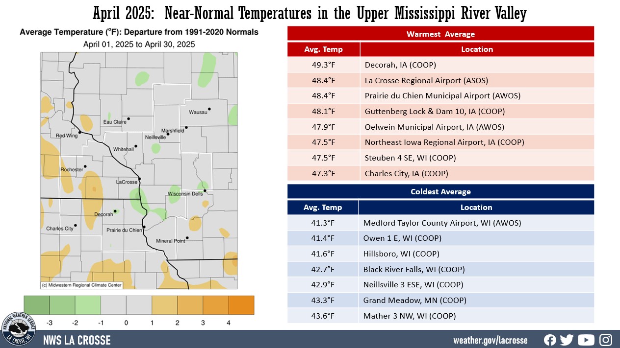
- During April 2025, average temperatures ranged from 41.3°F near Neillsville, WI (COOP) to 49.3°F at Decorah, IA (COOP).
- Temperature anomalies were within 2°F of normal.
- There was a 84°F difference between the warmest and coldest temperatures in the Upper Mississippi River Valley.
- The warmest temperature was 75°F at Boscobel Airport (ASOS) on April 28. Meanwhile, the coldest temperature was 8°F at Black River Falls (RAWS) on April 8.
|
 |
Precipitation - Wetter than Normal
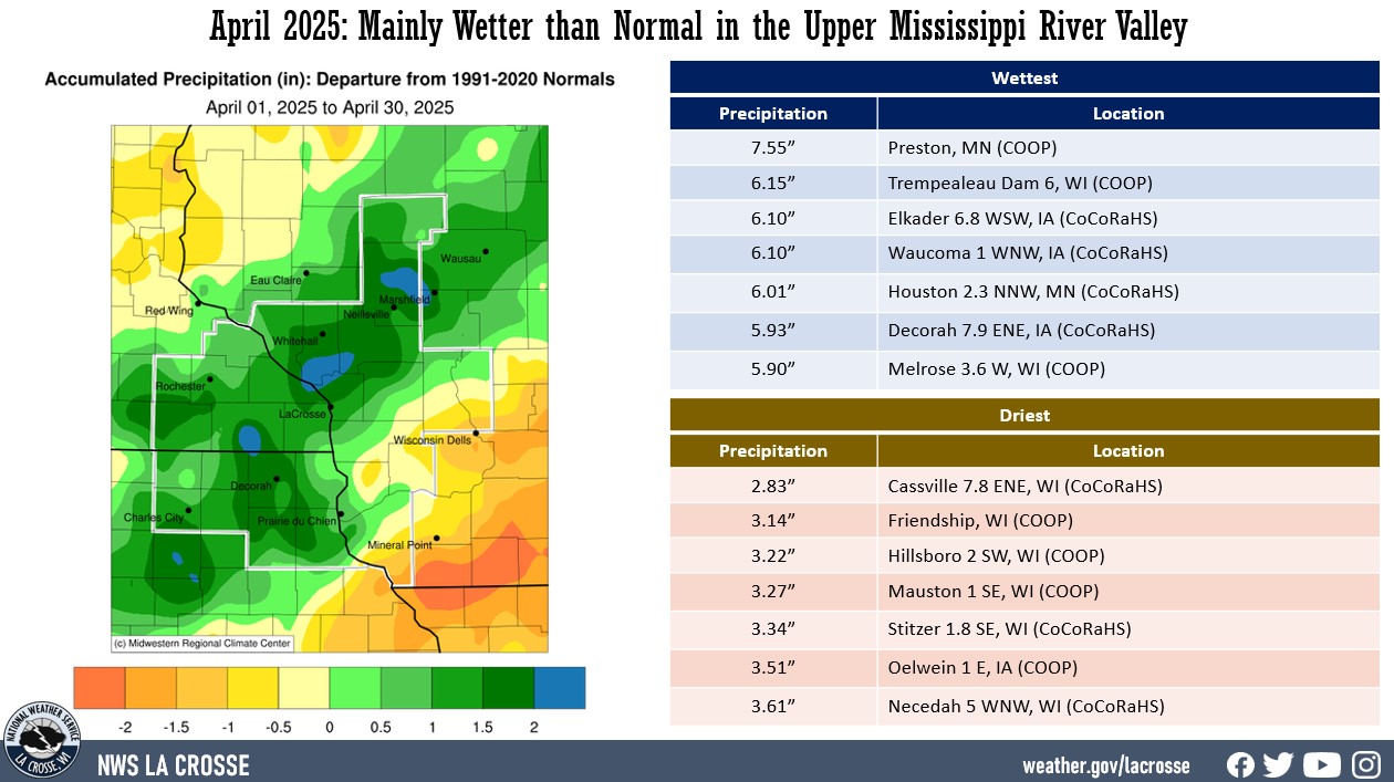
- Precipitation ranged from 2.83" near Cassville, WI (CoCoRaHS) to 7.55" at Preston, MN (COOP).
- These precipitation values ranged from 2” drier than normal to 2.5" wetter-than-normal.
- The greatest 1-day precipitation total was 2.26" at La Crescent, Dam 7, MN (COOP) from 7 am on April 20 to 7 am on April 21.
|
 |
| Snowfall - Near to Snowier than Normal |
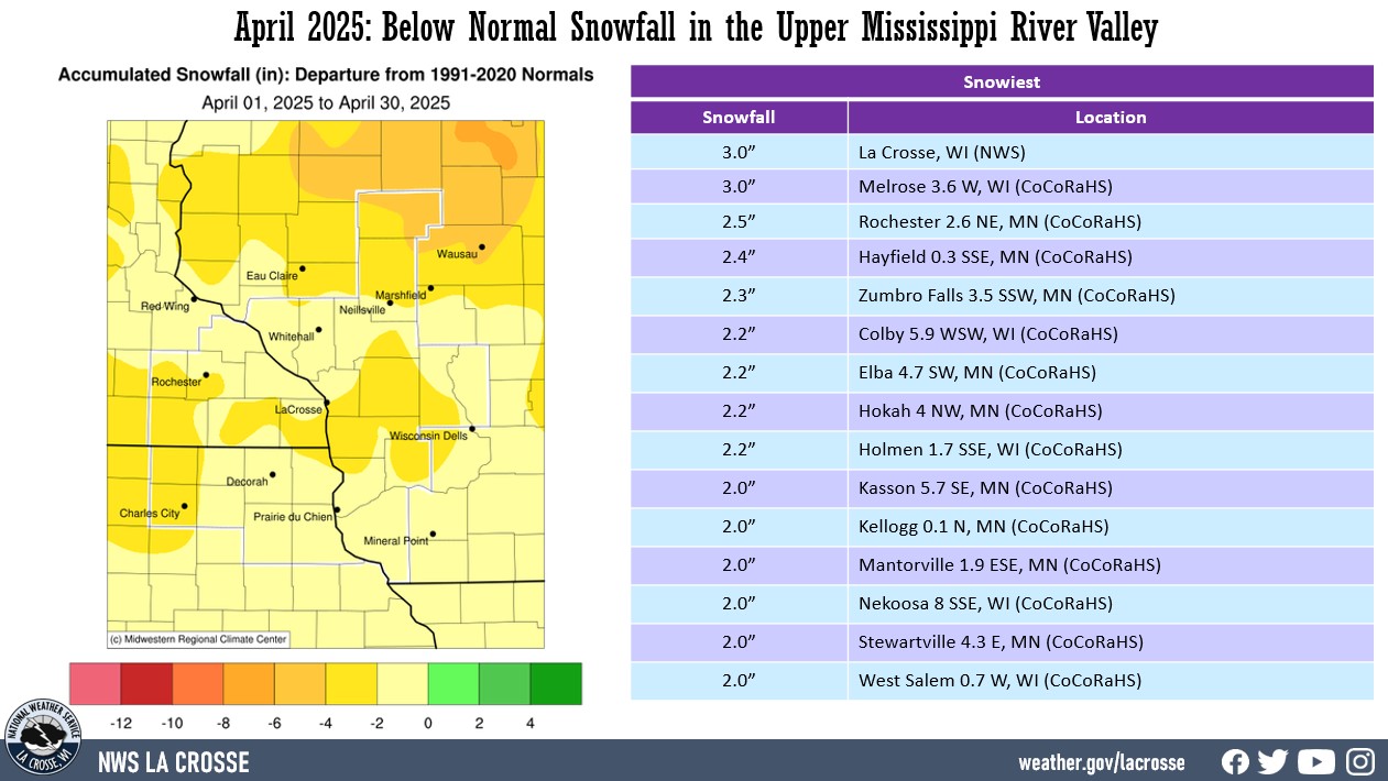
- Snowfall ranged from 0" at numerous locations to 3" at La Crosse (NWS) and near Melrose, WI.
- These snowfall values ranged from near normal to 6" below normal.
- The greatest 1-day snowfall total was 3" at La Crosse (NWS) on April 1 and near Melrose from 7 am on April 1 to 7 am on April 2.
|
 |
Below are the April 2025 climate summaries for La Crosse, WI, and Rochester, MN.
La Crosse, WI
April 2025 was Wetter and Slightly Cooler than Normal in La Crosse, WI
...April 2025 Highlights...
Temperatures - Slightly Cooler than Normal
- The average temperature was 48.4°F at La Crosse Regional Airport. This was 0.6°F cooler than the 1991-2020 normal of 49°F.
- The average high temperature was 59.3°F. This was 0.3°F cooler than the 1991-2020 normal of 59.6°F.
- The average low temperature was 37.5°F. This was 0.9°F cooler than the 1991-2020 normal of 38.4°F.
- The warmest temperature was 78°F on April 28 and the coldest temperature was 20°F on April 8.
|
 |
Precipitation - 13th Wettest
- A total of 5.20" of precipitation fell at La Crosse Regional Airport.
- This was 1.45" wetter than the 1991-2020 normal of 3.75".
- This was the 13th wettest April and the wettest since 2014 (7.03" - 2nd wettest).
- The wettest April occurred in 1973 when 7.31" fell.
- The table below lists the 20 wettest Aprils in La Crosse, WI.
20 Wettest Aprils
in La Crosse WI
1873-2025
Precipitation
Rank Total Year
---- ------------- ----
1 7.31 inches 1973
2 7.03 inches 2014
3 6.79 inches 1954
4 6.74 inches 2008
5 6.51 inches 1994
6 6.07 inches 1975
7 6.02 inches 1999
8 5.96 inches 1991
5.96 inches 1909
10 5.92 inches 2013
11 5.84 inches 1896
12 5.78 inches 1993
13 5.20 inches 2025
14 5.14 inches 2011
15 5.12 inches 1951
16 4.87 inches 2017
4.87 inches 1965
18 4.81 inches 1903
19 4.78 inches 2006
20 4.70 inches 1892
- 7 out of the 20 wettest Aprils have occurred this century.
- The wettest day was on April 20 when 1.66" fell.
- Precipitation fell on 17 days. Measurable precipitation fell on 11 days and a trace of precipitation fell on 6 days.
Snowfall - Below Normal
- A total of 1.7" of snow was reported by the official snow observer near La Crosse Regional Airport.
- This was 1.2" lower than the 1991-2020 normal of 2.9".
- Snowiest day occurred on April 1 when 1.1" of snow fell.
- Measurable snow fell on 2 days.
Snow Depth - Below the Long-Term Average
- The average snow depth was 0" near La Crosse Regional Airport.
- The long-term average is 0.1".
- The greatest snow depth was 1" on April 2.
- Measurable snow was on the ground 1 day.
...Records...
- April 20 - Wettest (1.66") - Previous Record was 1.57" in 1968
- April 28 - Warmest Low Tied (60°F) with 1970
...Looking ahead to May...
-
The normal high temperature in La Crosse rises from 66°F on May 1st to 77°F by the end of the month. The normal low temperature warms from 45°F on the 1st to 56°F by the end of the month. The normal mean temperature for the month is 61°F. La Crosse's warmest May occurred in 1934 with an average temperature of 68°F, and its coldest May occurred in 1907 with an average temperature of 50.8°F.
-
During May, the hottest temperature recorded was 107°F on May 31, 1934, and the coldest temperature was 26°F on May 2, 1911, May 3, 1971, and May 6, 1989.
-
The average precipitation for May is 4.33". The wettest May occurred in 2004 with 9.73" of precipitation, while the driest was in 1887 with 0.50". The wettest May day was 3.06" on May 19, 1912. Normally, there are 5 days with thunderstorms.
Rochester, MN
April 2025 was Wetter and Warmer than Normal in Rochester, MN
...April 2025 Highlights...
Temperatures - Warmer than Normal
- The average temperature was 46.4°F at Rochester International Airport. This was 1.2°F warmer than the 1991-2020 normal of 45.2°F.
- The average high temperature was 56.6°F. This was 1.3°F warmer than the 1991-2020 normal of 55.3°F.
- The average low temperature was 36.2°F. This was 1.1°F warmer than the 1991-2020 normal of 35.1°F.
- The warmest temperature was 74°F on April 28 and the coldest temperature was 19°F on April 8.
|
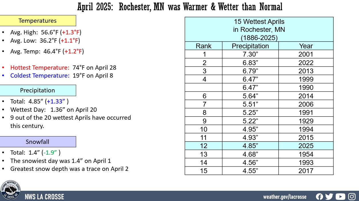 |
Precipitation - 12th Wettest
- A total of 4.85" of precipitation fell at Rochester International Airport.
- This was 1.33" wetter than the 1991-2020 normal of 3.52".
- This was the 12th wettest April and the wettest since 2022 (6.83" - 2nd wettest).
- The wettest April occurred in 2001 when 7.30" fell.
- The table below lists the 20 wettest Aprils in Rochester, MN.
20 Wettest Aprils
in Rochester MN
1886-2025
Precipitation
Rank Total Year
---- ------------- ----
1 7.30 inches 2001
2 6.83 inches 2022
3 6.79 inches 2013
4 6.47 inches 1999
6.47 inches 1990
6 5.64 inches 2014
7 5.51 inches 2006
8 5.25 inches 1991
9 5.22 inches 1929
10 4.95 inches 1994
11 4.93 inches 2015
12 4.85 inches 2025
13 4.68 inches 1954
14 4.56 inches 1993
15 4.55 inches 2017
16 4.54 inches 1945
17 4.44 inches 1919
18 4.26 inches 1973
19 4.17 inches 2008
4.17 inches 1930
- 9 out of the 20 wettest Aprils have occurred this century.
- The wettest day was on April 20 when 1.36" fell.
- Precipitation fell on 14 days. Measurable precipitation fell on 12 days and a trace of precipitation fell on 2 days.
Snowfall - Below Normal
- A total of 1.4" of snow was reported by the official snow observer near Rochester International Airport.
- This was 1.9" lower than the 1991-2020 normal of 3.3".
- Snowiest day occurred on April 1 when 1.4" of snow fell.
- Measurable snow fell on 1 day and a trace fell on another.
Snow Depth - Below the Long-Term Average
- The average snow depth was 0" near Rochester International Airport.
- This was 0.2" below the long-term average of 0.2".
- The greatest snow depth was a trace on April 2.
...Records...
- April 28 - Wettest (0.76") - Previous Record was 0.63 inches in 1938 and 1989
...Looking ahead to May...
- The normal high temperature in Rochester rises from 62°F on May 1st to 74°F by the end of the month. The normal low temperature rises from 41°F on the 1st to 53°F by the end of the month. The normal mean temperature for the month is 57.6°F. Rochester’s warmest May occurred in 1934 with an average temperature of 66.2°F, and its coldest May occurred in 1888 with an average of only 49.6°F.
- During May, the hottest temperature was 106°F on May 31, 1934, and the coldest temperature was 21°F on May 3 in 1910, and 1967. Normally, there is only 1 day with temperatures at or above 90°F.
- The average precipitation for May is 4.35". The wettest May occurred in 2013 with 12.26" of precipitation. While the driest was in 1934 with 0.40". The wettest May day was 4.02" on May 17, 2000. Normally, there are 5 days with thunderstorms.


 Weather Story
 Weather Map
 Local Radar