Multiple rounds of strong to severe thunderstorms may produce very large hail, swaths of damaging wind, a few tornadoes and heavy rain across parts of Texas into the lower Mississippi and Tennessee Valleys. Gusty winds and dry conditions will continue to promote elevated to critical fire weather conditions across the southern High Plains. Read More >
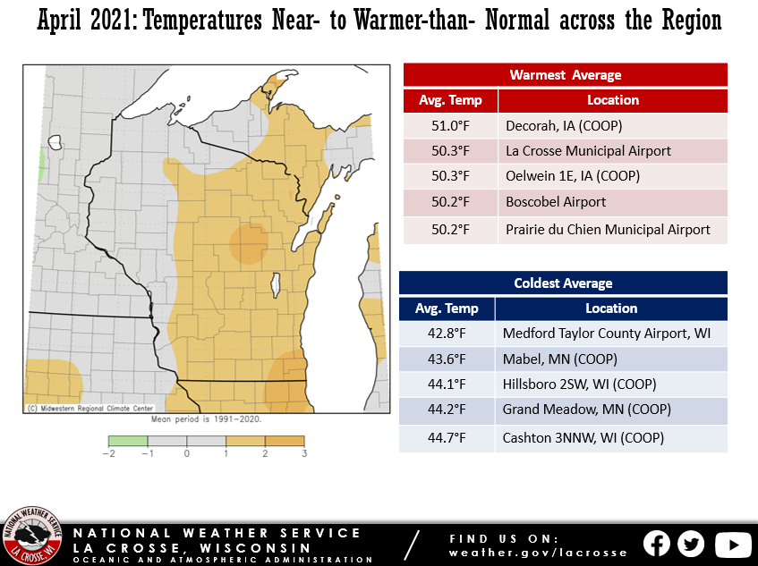
During April 2021, average temperatures were anywhere from 1°F colder-than-normal to 2°F warmer-than-normal in the Upper Mississippi River Valley. Monthly average temperatures ranged from 42.8°F at Medford, WI to 51°F at Decorah, IA.
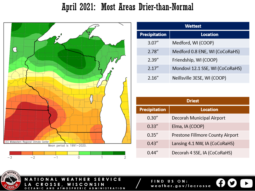
Precipitation was drier-than-normal. Precipitation totals ranged from 0.30” at Decorah IA to 3.07” at Medford, WI. It was the driest April in Decorah, IA. The previous record was 0.68” in 1959. It was the 3rd driest April in Fayette, IA, and the driest since 1942 (0.28”). It was the 4th driest April in Rochester MN and the driest since 1946. Finally, it was the 5th driest April in New Hampton, IA (driest since 2004 - 0.58”) and Austin, MN (driest since 1983 – 0.18”).
Below are the April 2021 temperature and precipitation anomalies for the Upper Mississippi River Valley.
 |
 |
| April Temperature Anomalies | April Precipitation Anomalies |
The average temperature was 50.3 degrees at La Crosse Municipal Airport. This was 1.7 degrees warmer than the 1981-2010 normal of 48.6 degrees. This was the warmest April since 2017 (52.5 degrees). The warmest weather occurred from April 4-6 when high temperatures reached or exceeded 80F. This was the earliest in the year that there have been 3 consecutive 80 degrees days. The previous record was April 5-7, 1991. The warmest temperature was 82 degrees on April 6. Meanwhile, the coldest temperature was 21 degrees on April 1.
A total of 1.32 inches of precipitation fell. This was 2.02 inches below the 1981-2010 normal of 3.38 inches. This was the 5th consecutive month with below-normal precipitation. Since December 1, 2020, a total of 4.81 inches of precipitation fell (precipitation deficit of 4.10 inches). This was the 11th lowest precipitation total for this time period and the least since 1964 (4.59 inches). The lowest total was 2.83 inches in 1873. This lack of precipitation resulted in a moderate (D1) drought developing in the area by the end of the month.
There was a trace of snow (tied for 11th least). This was 1.7 inches below normal. The last time we had a trace or no snow in April was 2017 when no snow fell.
There were 2 records.
Only 0.81 inches of precipitation fell during the month. This was 2.43 inches drier than the 1981-2010 normal of 3.24 inches. This was the 4th driest April. It was the driest April since 1946 (driest April). The only other Aprils which were drier were 1943 (0.69 inches - 2nd driest) and 1936 (0.79 inches - 3rd driest).
There was a trace of snow (tied for 8th least). This was 3.3 inches below normal. The last time we had a trace or no snow in April was 2017 when a trace of snow fell. This was in contrast to the last 3 Aprils where the average snowfall was 11.2 inches (17 inches in 2018, 8.2 inches in 2019, and 8.5 inches in 2020).
The average temperature was 46.3 degrees at Rochester International Airport. This was 0.4 degrees cooler than the 1981-2010 normal of 46.7 degrees. This was the warmest April since 2017 (48.1 degrees). The warmest weather occurred from April 4-6 when high temperatures were around 80F. The warmest temperature was 81 degrees on April 4. Meanwhile, the coldest temperature was 16 degrees on April 1.
There were 2 records.