Upper Mississippi River Climate Summary for Astronomical Spring 2025:
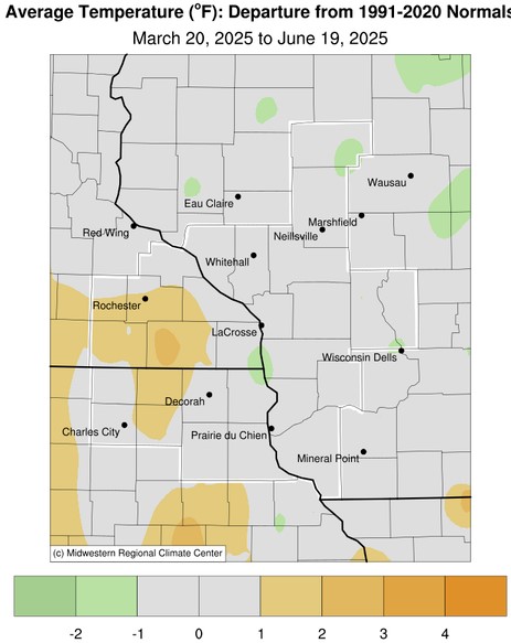
Temperatures - Mainly Near Normal
|
|
- From March 20 through June 19, average temperatures ranged from 48.3°F at Medford Taylor County Airport, WI (AWOS) to 55.5°F at Prairie du Chien Municipal Airport, WI (AWOS) and Oelwein Municipal Airport, IA (AWOS).
- Temperature anomalies ranged from 2°F colder than normal to 3°F warmer than normal.
- The hottest temperature was 93°F at Boscobel Airport (AWOS), WI on May 15.
- The coldest temperature was 8°F at Black River Falls, WI (AWOS) on April 8.
|
 |
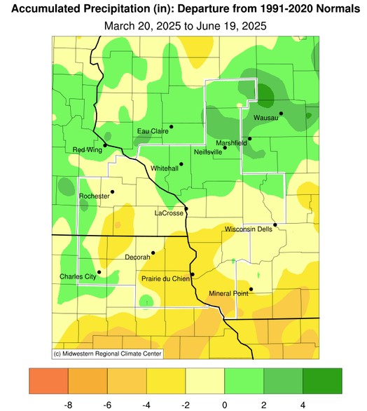
Precipitation - Highly Variable
- Precipitation totals ranged from 8.36" near Lancaster, WI (COOP) to 15.95" near Greenwood, WI (CoCoRaHS).
- Precipitation anomalies ranged from 6" drier than normal to 4" wetter than normal.
- The wettest day was 2.40" near Fredericksburg, IA (CoCoRaHS) from June 14 through June 15.
|
 |
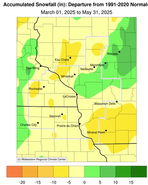
Snowfall - Highly Variable
- Snowfall totals ranged from a trace at Lynxville Dam 9, WI (COOP) and near Cassville, WI (CoCoRaHS) to 13.1" near Mather, WI (COOP).
- Snowfall anomalies ranged from 6" below normal to 8" above normal.
- The snowiest day was 3" at NWS La Crosse on April 1 and near Melrose, WI from April 1 into April 2.
|
 |
Below are the climate summaries for the 2025 meteorological spring in La Crosse, WI and Rochester, MN
La Crosse, WI
Astronomical Spring 2025 was Slightly Warmer-and Wetter-than-Average at La Crosse, WI
During the astronomical spring of 2025, La Crosse Regional Airport was slightly warmer (55.2°F or 0.6°F warmer than average) and drier (10.93 inches or 0.67 inches wetter than average) than the long-term average (1873-2025). More details on these statistics can be found below.
Temperatures - Slightly Warmer than Average
- From March 20 through June 19, La Crosse Regional Airport had an average temperature of 55.2°F. This was 0.6°F warmer than the long-term average of 54.6°F. This made it the 11th consecutive spring to average warmer than average. This includes the 5th warmest (2021), 12th warmest (2017), 21st warmest (2023), and the 24th warmest (2015).
- The average high temperature was 66.1°F. This was 1.4°F warmer than the long-term average of 64.7°F.
- The average low temperature was 44.4°F. This was 0.1°F colder than the long-term average of 44.5°F.
- The warmest high temperature was 89°F on June 2.
- The coldest high temperature was 37°F on March 30.
- The warmest low temperature was 66°F on June 17.
- The coldest low temperature was 20°F on April 8.
- There were no days in which the high temperature reached or exceeded 90°F. The long-term average is 2 days.
- There were 17 days in which the low temperature was 32°F or colder. The long-term average is 17 days.
Precipitation - Slightly Wetter than Average
- From March 20 through June 19, La Crosse Regional Airport received 10.93 inches of precipitation. This was 0.67 inches wetter than the long-term average of 10.26 inches.
- Measurable precipitation (0.01 inches or greater) fell on 34 days (37%) and a trace of precipitation fell on 17 days (18.5%).
Number of days with...
None 40 days (43.5%)
Trace 18 days (19.6%)
0.01-0.09 inches 14 days (15.2%)
0.10-0.24 inches 7 days ( 7.6%)
0.25-0.49 inches 6 days ( 6.7%)
0.50-0.99 inches 5 days ( 5.4%)
1.00-1.99 inches 2 days ( 2.2%)
- The wettest spring day was 1.70 inches on May 20.
Snowfall - Below Average
- From March 20 through June 19, the snow observer near La Crosse Regional Airport measured 2.1 inches of snow. This was 3 inches above the long-term average of 5.1 inches.
- Measurable snow (0.1 inches or greater) fell on 4 days (4.3%) and a trace of snow fell on 2 other days (2.2%).
Number of days with...
No snow 86 Days (93.5%)
Trace 2 Days ( 2.2%)
0.1-0.9 inches 3 Days ( 3.3%)
1.0-2.9 inches 2 Days (1.1%)
- The snowiest day was 1.1 inches of snow on April 1.
Snow Depth - Average
- From March 20 through June 19, the average snow depth near La Crosse Regional Airport was 0.1 inches. This was the same as the long-term average of 0.1 inches.
Number of days with...
No snow 87 Days (94.6%)
Trace 1 Day ( 1.1%)
1-3 inches 3 Days ( 3.3%)
4-6 inches 1 Days ( 1.1%)
- The greatest snow depth was 4 inches on March 20.
Rochester, MN
Astronomical Spring 2025 was Warmer and Slightly Wetter than Average at Rochester, MN
During the astronomical spring of 2025, temperatures averaged warmer than average (54°F or 1.8°F warmer than average) and it was slightly wetter than average (10.59 inches or 0.20 inches wetter than average) at Rochester International Airport. More details on these statistics can be found below.
Temperatures - Warmer than Average
- From March 20 through June 19, Rochester International Airport had an average temperature of 54°F. This was 1.8°F warmer than the long-term average of 52.2°F.
- The average high temperature was 64.4°F. This was 1.6°F warmer than the long-term average of 62.8°F.
- The average low temperature was 43.7°F. This was 2.1°F warmer than the long-term average of 41.6°F. This was the 19th warmest.
- The warmest high temperature was 90°F on June 2.
- The coldest high temperature was 34°F on March 20.
- The warmest low temperature was 68°F on June 16.
- The coldest low temperature was 19°F on March 22 and April 8.
- There was 1 day in which the high temperature reached or exceeded 90°F. The long-term average is 2 days.
- There were 18 days in which the low temperature was 32°F or colder. The long-term average is 24 days.
Precipitation - Slightly Wetter than Average
- From March 20 through June 19, Rochester International Airport received 10.59 inches of precipitation. This was 0.20 inches wetter than the long-term average of 10.39 inches.
- Measurable precipitation (0.01 inches or greater) fell on 37 days (40.2%) and a trace of precipitation fell on 9 days (9.8%).
Number of days with...
None 46 days (50.0%)
Trace 9 days ( 9.8%)
0.01-0.09 inches 12 days (13.0%)
0.10-0.24 inches 14 days (15.2%)
0.25-0.49 inches 4 days ( 4.3%)
0.50-0.99 inches 4 days ( 4.3%)
1.00-1.99 inches 3 day ( 3.3%)
- The wettest spring day was 1.42 inches on May 20.
Snowfall - Below Average
- From March 20 through June 19, the snow observer near Rochester International Airport measured 2.2 inches of snow. This was 4.5 inches below than the long-term average of 6.7 inches.
- Measurable snow (0.1 inches or greater) fell on 2 days (2.2%) and a trace of precipitation fell on 3 days (3.3%).
Number of days with...
No snow 87 Days (94.6%)
Trace 3 Days ( 3.3%)
0.1-0.9 inches 1 Day ( 1.1%)
1.0-2.9 inches 1 Day ( 1.1%)
- The snowiest day was 1.4 inches on April 1.
Snow Depth - Less than Average
- From March 19 through June 19, the average snow depth near Rochester International Airport was 0.1 inches. This was 0.2 inches below the long-term average of 0.3 inches.
Number of days with...
No snow 88 Days (95.7%)
Trace 1 Day ( 1.1%)
1-3 inches 2 Days ( 2.2%)
4-6 inches 1 Day ( 1.1%)
- The greatest snow depth was 6 inches on March 20.


 Weather Story
 Weather Map
 Local Radar