Overview
|
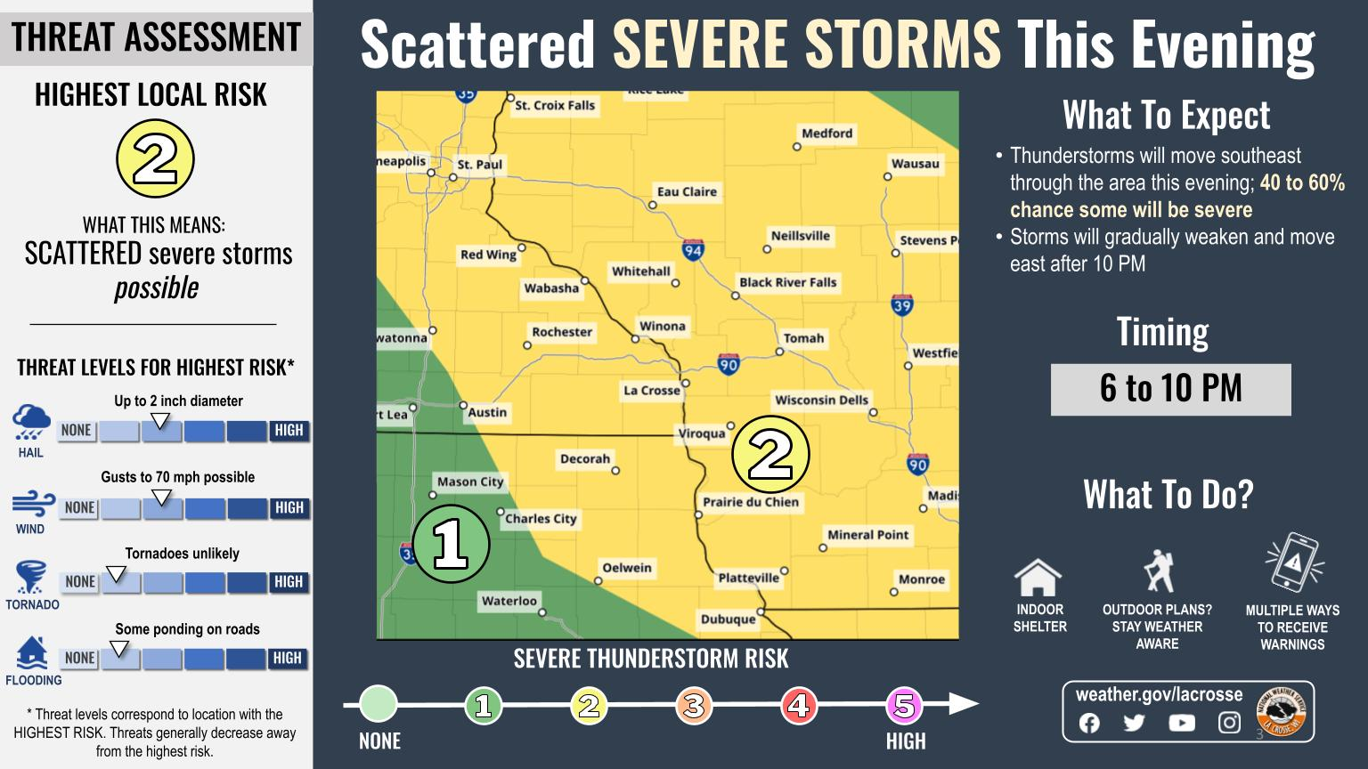
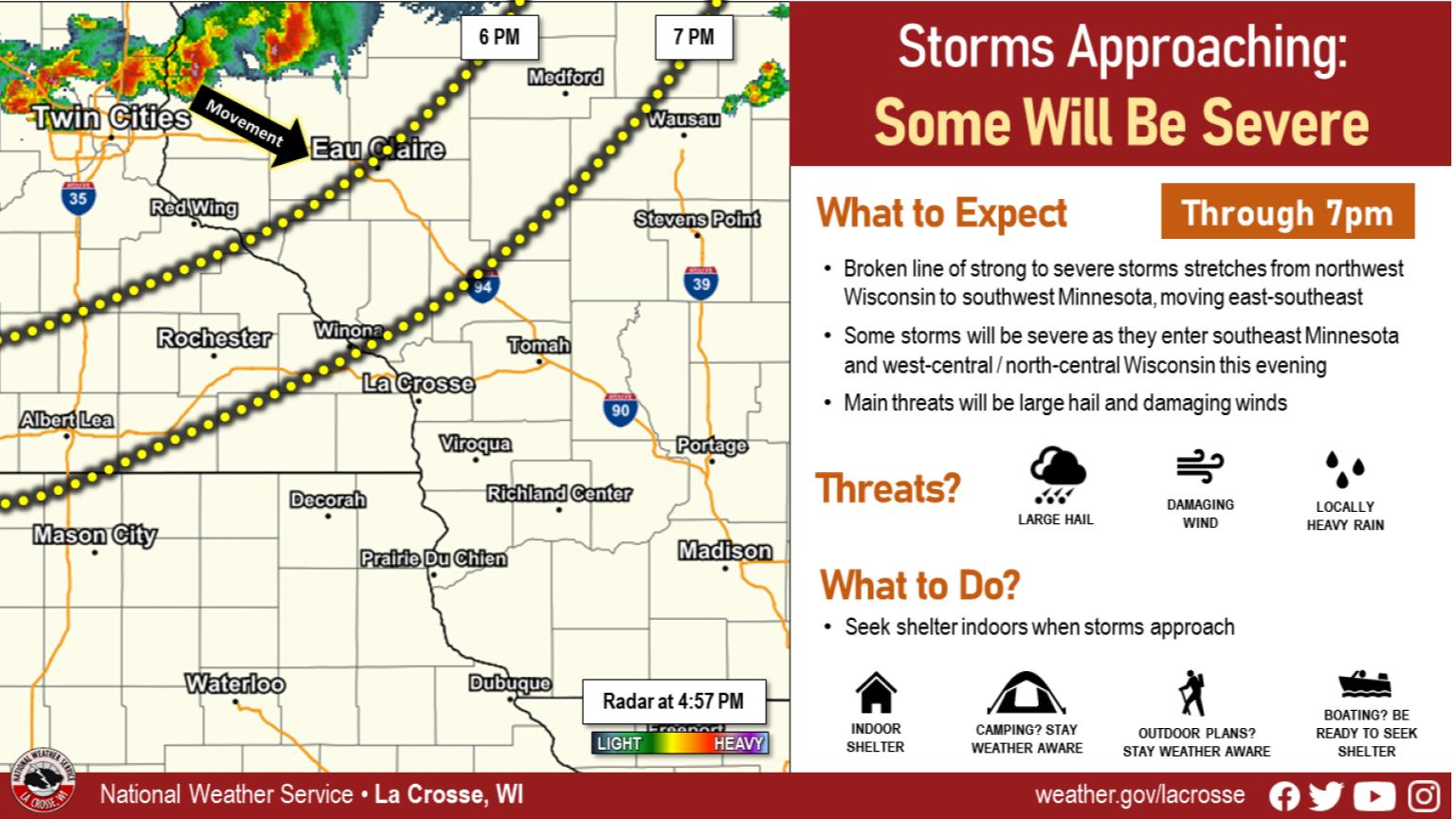
Scattered strong to severe thunderstorms developed along and ahead of a cold front during the evening of August 11. These storms initially produced large hail when they were northeast of the area. Strong thunderstorm wind gusts of 40 to around 70 mph produced scattered reports of wind damage across southeast Minnesota, northeast Iowa, and from southwest into central Wisconsin. The highest wind gusts were 71 mph at Kellogg, MN, and 68 mph at La Crosse Regional Airport. |
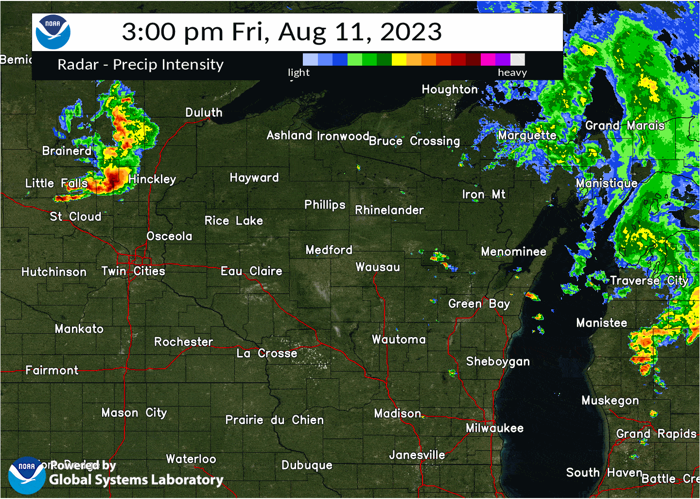 Radar loop from 3 PM through midnight - August 11, 2023 |
Photos & Video:
 |
 |
 |
 |
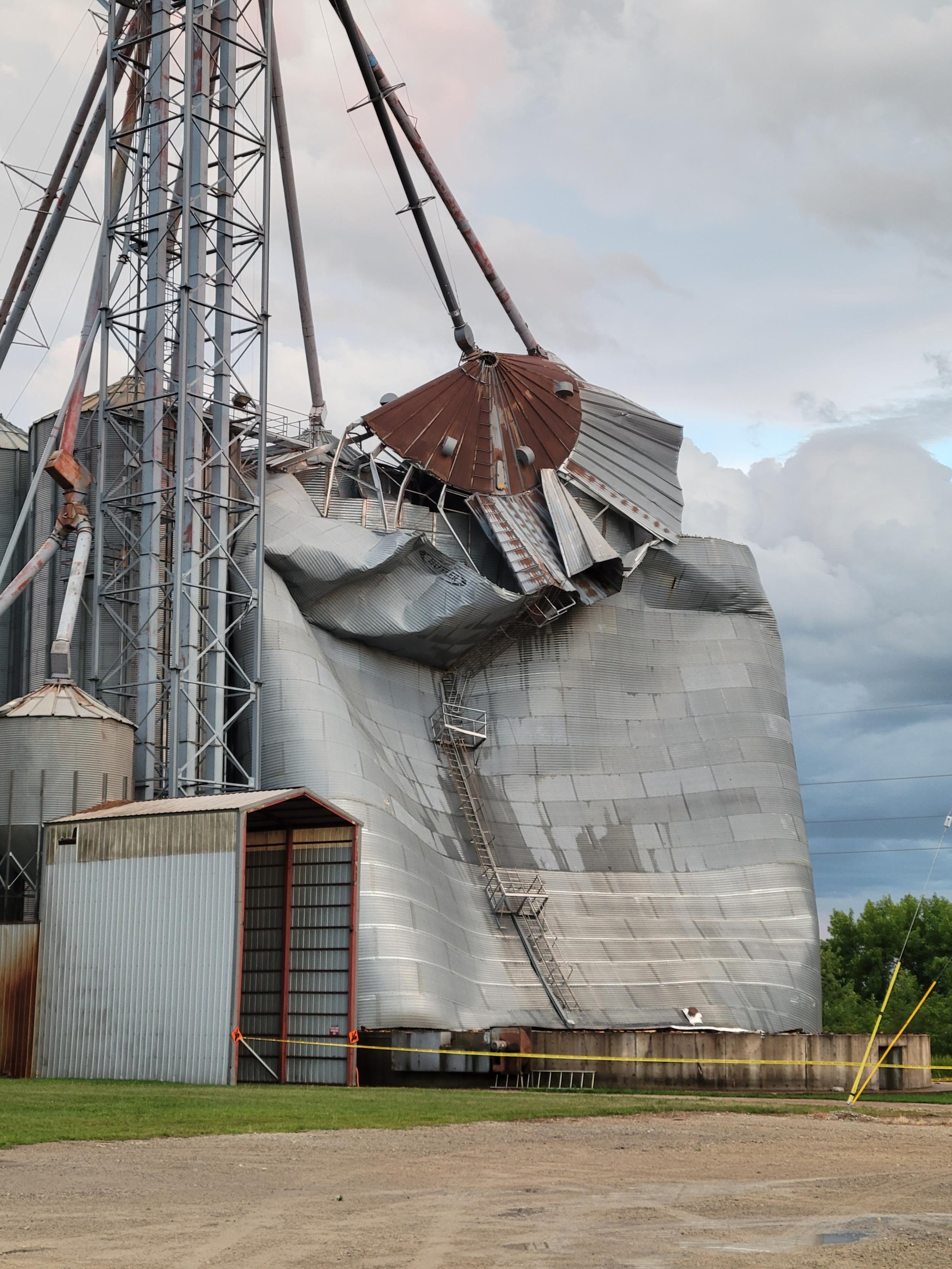
| Damaged Grain Bin Claremont, MN (Dave Purscell) |
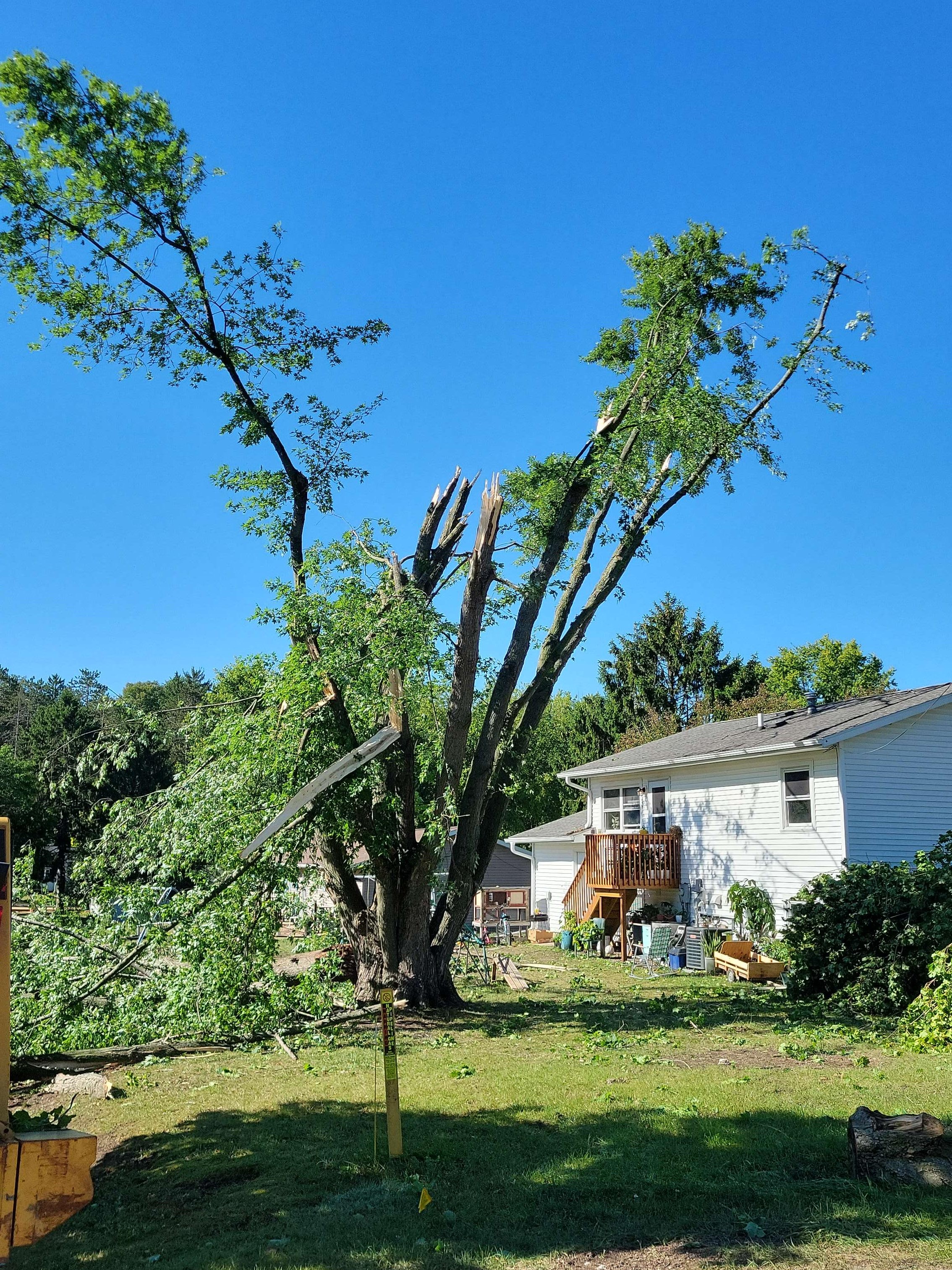
Tree Damage Westby, WI (NWS La Crosse) |
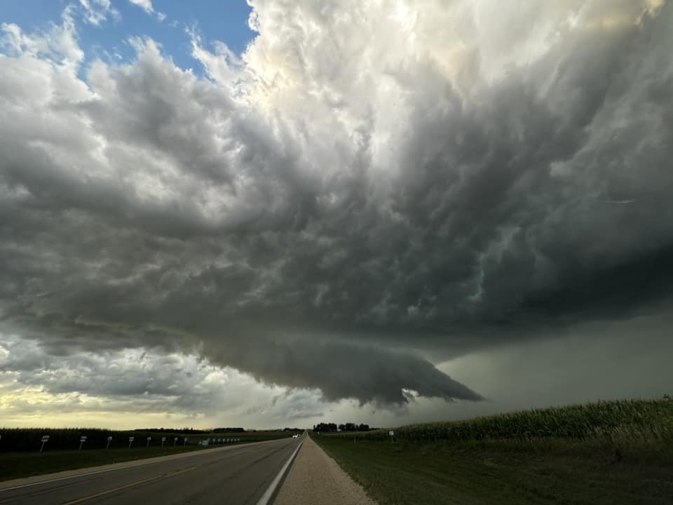
Wall cloud north of Grand Meadow, MN (Timothy Shorter) |
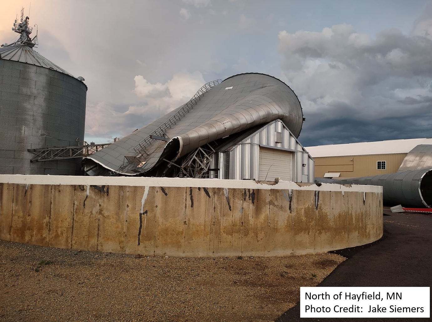
Damaged Grain Bin north of Hayfield, MN (Jake Siemers) |
Radar:
 |
 |
||
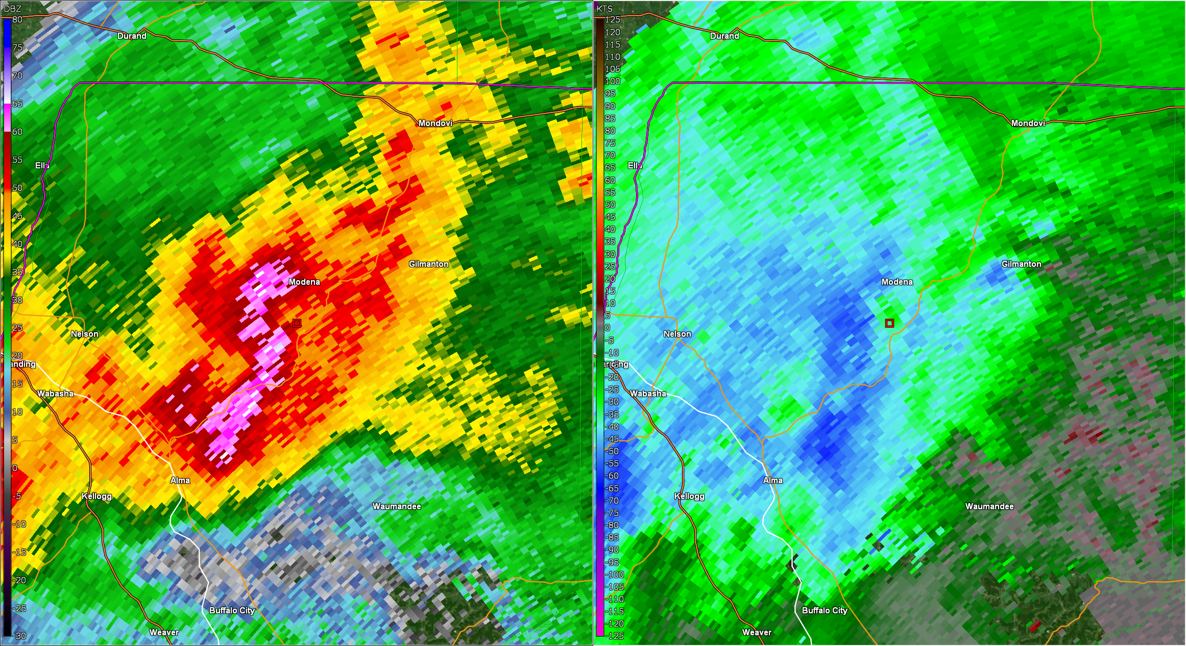
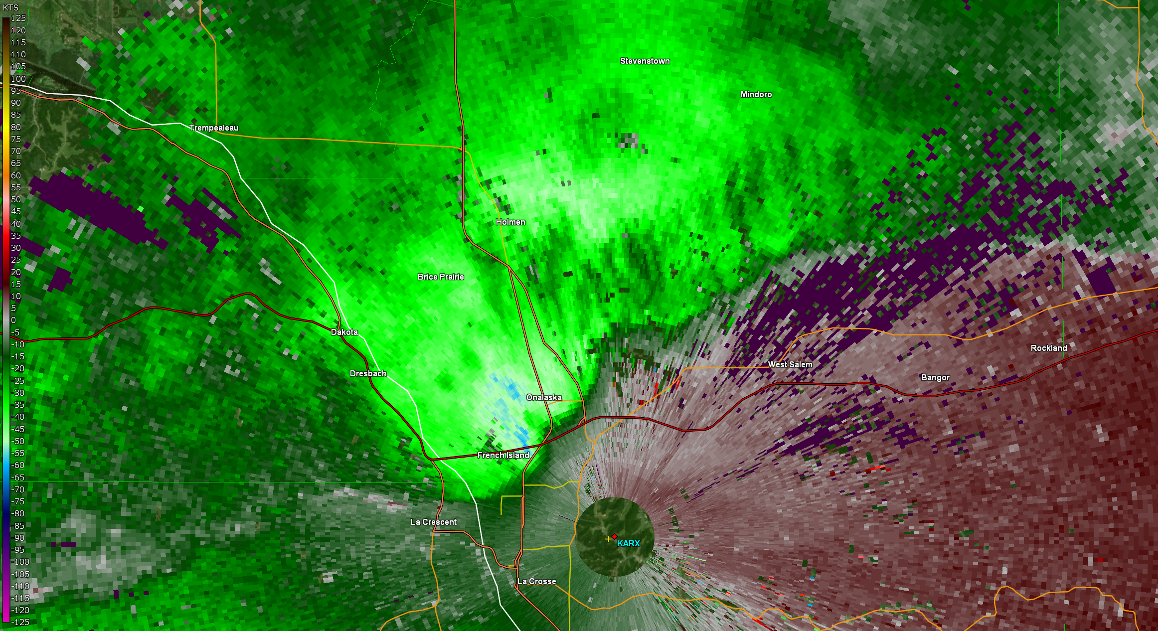
| Radar reflectivity and velocity over Buffalo County around 7 pm August 11 | Radar velocity of storm nearing La Crosse at 7:55 PM August 11 | Caption | Caption |
Storm Reports
..TIME...   ...EVENT...      ...CITY LOCATION...     ...LAT.LON...
..DATE...   ....MAG....      ..COUNTY LOCATION..ST.. ...SOURCE....
            ..REMARKS..

0630 PM     Tstm Wnd Gst     1 W Lake City           44.44N 92.28W
08/11/2023  M48 MPH          Wabasha            MN   Mesonet

            Mesonet station DW8097 Lake City.

0633 PM     Tstm Wnd Gst     Longwood                44.89N 90.60W
08/11/2023  M60 MPH          Clark              WI   Trained Spotter


0647 PM     Hail             Nelson                  44.42N 92.00W
08/11/2023  E0.88 inch       Buffalo            WI   Trained Spotter

            pea to nickel sized.

0647 PM     Tstm Wnd Gst     Loyal                   44.74N 90.50W
08/11/2023  E70 MPH          Clark              WI   Public


0648 PM     Tstm Wnd Dmg     3 NE Kellogg            44.34N 91.96W
08/11/2023                   Wabasha            MN   Public

            Several tree limbs down near the Mississippi
            River.

0653 PM     Hail             1 N Loyal               44.75N 90.50W
08/11/2023  E1.00 inch       Clark              WI   Public


0657 PM     Funnel Cloud     4 SSE Dodge Center      43.97N 92.82W
08/11/2023                   Dodge              MN   Public


0658 PM     Tstm Wnd Dmg     Claremont               44.04N 93.00W
08/11/2023                   Dodge              MN   Broadcast Media

            Grain elevator/bin sustained considerable damage
            from strong winds.

0705 PM     Tstm Wnd Dmg     3 WNW Dodge Center      44.05N 92.91W
08/11/2023                   Dodge              MN   Public

            Social media picture of large tree limb down
            between Claremont and Dodge Center.

0705 PM     Tstm Wnd Gst     7 SW Lake City          44.38N 92.37W
08/11/2023  M45 MPH          Wabasha            MN   Mesonet

            Mesonet station MN143 US 63 - Lake City - MP 62.9.

0708 PM     Tstm Wnd Dmg     Hayfield                43.89N 92.85W
08/11/2023                   Dodge              MN   Public

            Grain bin flattened - time estimated by radar.

0715 PM     Hail             High Forest             43.84N 92.55W
08/11/2023  E1.00 inch       Olmsted            MN   Trained Spotter


0715 PM     Tstm Wnd Dmg     3 NNW Buffalo           44.27N 91.87W
08/11/2023                   Buffalo            WI   Public

            Buffalo County Sheriffs Office reported a
            porta potty blown across State Rd. Time
            estimated via radar.

0715 PM     Tstm Wnd Gst     2 ESE Dodge Center      44.02N 92.82W
08/11/2023  M51 MPH          Dodge              MN   AWOS

            AWOS station KTOB Dodge Center Airport.

0718 PM     Tstm Wnd Dmg     6 E Black River Falls   44.29N 90.73W
08/11/2023                   Jackson            WI   Public

            Jackson County Sheriffs office passed along
            trees down near Wazee Lake. Time estimated
            via radar.

0726 PM     Funnel Cloud     3 W Arcadia             44.25N 91.55W
08/11/2023                   Buffalo            WI   Public

            Pulsing up, down.

0728 PM     Hail             2 W High Forest         43.84N 92.60W
08/11/2023  M0.50 inch       Olmsted            MN   Public

            Report from mPING: Half-inch (0.50 in.).

0732 PM     Tstm Wnd Gst     Winona                  44.05N 91.66W
08/11/2023  M51 MPH          Winona             MN   Emergency Mngr


0733 PM     Tstm Wnd Dmg     1 SE Goodview           44.05N 91.69W
08/11/2023                   Winona             MN   Emergency Mngr

            Tree down on highway 14.

0740 PM     Tstm Wnd Dmg     3 NE Trempealeau        44.04N 91.40W
08/11/2023                   Trempealeau        WI   Law Enforcement

            Trempealeau Sheriffs Office reported trees down
            on County Road K. Time estimated via radar.

0741 PM     Tstm Wnd Dmg     Galesville              44.08N 91.36W
08/11/2023                   Trempealeau        WI   Public

            Large tree blown down.

0755 PM     Tstm Wnd Dmg     3 NNE Tomah             44.03N 90.48W
08/11/2023                   Monroe             WI   Public

            Report from mPING: 3-inch tree limbs broken;
            Power poles broken.

0756 PM     Tstm Wnd Gst     Onalaska                43.89N 91.23W
08/11/2023  E60 MPH          La Crosse          WI   Public


0800 PM     Tstm Wnd Gst     3 WNW Spring Valley     43.70N 92.44W
08/11/2023  E70 MPH          Fillmore           MN   Trained Spotter

            delayed report, wind gusts of 65 to 70mph.

0801 PM     Tstm Wnd Dmg     1 S La Crosse           43.81N 91.23W
08/11/2023                   La Crosse          WI   Public

            La Crosse County Sheriffs Office reported 8
            trees down within the city of La Crosse.
            Time estimated via radar.

0801 PM     Tstm Wnd Gst     2 NNE French Island     43.88N 91.25W
08/11/2023  M68 MPH          La Crosse          WI   ASOS

            ASOS station KLSE La Crosse Regional Airport.

0804 PM     Tstm Wnd Dmg     3 S Barre Mills         43.80N 91.11W
08/11/2023                   La Crosse          WI   Public

            La Crosse County Sheriffs Office reported
            tree(s) down on County Road OA. Time
            estimated via radar.

0805 PM     Tstm Wnd Dmg     2 SW Waumandee          44.28N 91.74W
08/11/2023                   Buffalo            WI   Public

            Buffalo Cty Sheriffs Office passed along
            power line down.

0805 PM     Tstm Wnd Dmg     1 SSE Onalaska          43.88N 91.21W
08/11/2023                   La Crosse          WI   Public

            Report from mPING: 1-inch tree limbs broken;
            Shingles blown off.

0823 PM     Tstm Wnd Dmg     1 NNW Westby            43.66N 90.86W
08/11/2023                   Vernon             WI   NWS Storm Survey

            Most damage 60 to 70 mph with isolated peaks
            to 80 mph with larger snapped maple trees.
            Time estimated via radar.

0824 PM     Tstm Wnd Dmg     Westby                  43.66N 90.85W
08/11/2023                   Vernon             WI   Public

            Multiple reports of many power lines down
            and loss of power. Time estimated via radar.

0908 PM     Tstm Wnd Dmg     4 NW Ithaca             43.39N 90.33W
08/11/2023                   Richland           WI   Public

            Richland County Sheriffs Office reported
            tree down blocking the road. Time estimated
            via radar.

0940 PM     Tstm Wnd Gst     3 SSE Blue River        43.16N 90.54W
08/11/2023  M50 MPH          Grant              WI   Public


1036 PM     Tstm Wnd Gst     3 ENE Bridgeport        43.03N 91.01W
08/11/2023  M55 MPH          Crawford           WI   Public
Rainfall/Wind Gusts
Rain Reports:
There were 2 systems that brought rainfall to the region on August 11. The first fell during the overnight and early morning and a second fell during the evening. Here are the rainfall totals for the day.
...PRECIPITATION REPORTS...

Location                     Amount    Time/Date       Lat/Lon

...Iowa...

...Allamakee County...
3 S Dorchester               0.01 in   0100 AM 08/12   43.42N/91.51W

...Chickasaw County...
Ionia 2W                     1.25 in   0145 AM 08/12   43.03N/92.50W
New Hampton                  0.70 in   0207 AM 08/12   43.05N/92.30W

...Clayton County...
Littleport                   0.32 in   0145 AM 08/12   42.75N/91.37W
Mcgregor                     0.29 in   0209 AM 08/12   43.02N/91.19W
Monona                       0.25 in   0209 AM 08/12   43.04N/91.39W
1 WSW Marquette              0.13 in   0200 AM 08/12   43.04N/91.21W

...Fayette County...
Eldorado 1E - Turkey River   0.64 in   0145 AM 08/12   43.05N/91.81W

...Floyd County...
Charles City                 0.97 in   0207 AM 08/12   43.05N/92.67W
2 NE Dougherty               0.89 in   0205 AM 08/12   42.95N/93.01W
Charles City                 0.61 in   0130 AM 08/12   43.06N/92.67W

...Howard County...
Saratoga                     0.74 in   0200 AM 08/12   43.35N/92.42W
Riceville                    0.61 in   0200 AM 08/12   43.36N/92.48W

...Mitchell County...
St.Ansgar                    1.54 in   0200 AM 08/12   43.38N/92.92W
Stacyville                   0.60 in   0207 AM 08/12   43.44N/92.78W

...Winneshiek County...
1 ENE Jackson Junction       0.92 in   0209 AM 08/12   43.11N/92.04W
Spillville                   0.65 in   1000 PM 08/11   43.21N/91.95W
Spillville                   0.59 in   0130 AM 08/12   43.21N/91.95W
Decorah                      0.34 in   0209 AM 08/12   43.30N/91.79W
Decorah                      0.26 in   0700 PM 08/11   43.30N/91.80W
Decorah                      0.06 in   0145 AM 08/12   43.30N/91.80W

...Minnesota...

...Dodge County...
Hayfield                     0.70 in   0207 AM 08/12   43.89N/92.85W
Dodge Center 0.5 W           0.32 in   0600 PM 08/11   44.03N/92.86W
Wasioja                      0.08 in   0604 PM 08/11   44.07N/92.82W
Hayfield 0.3 SSE             0.06 in   0130 AM 08/12   43.89N/92.85W

...Fillmore County...
Lanesboro                    0.70 in   0130 AM 08/12   43.72N/91.98W
1 NNW Fillmore               0.22 in   0130 AM 08/12   43.76N/92.27W
Preston Airport              0.04 in   0155 AM 08/12   43.68N/92.17W

...Houston County...
Mound Prairie                0.79 in   0100 AM 08/12   43.78N/91.45W
Mound Prairie                0.58 in   1245 AM 08/12   43.78N/91.45W
Hokah                        0.51 in   0205 AM 08/12   43.80N/91.43W
Houston                      0.35 in   0209 AM 08/12   43.77N/91.58W

...Mower County...
Lansing - Cedar River        0.63 in   0100 AM 08/12   43.75N/92.96W
Dobbins Creek                0.50 in   0130 AM 08/12   43.68N/92.94W
Lansing - Cedar River        0.48 in   0130 AM 08/12   43.75N/92.96W
Austin                       0.06 in   0209 AM 08/12   43.65N/93.00W

...Olmsted County...
Rochester                    1.15 in   0209 AM 08/12   44.04N/92.44W
3 W Rochester                0.85 in   0130 AM 08/12   44.02N/92.53W
Byron                        0.81 in   0200 AM 08/12   44.04N/92.64W
Rochester International Airp 0.68 in   0154 AM 08/12   43.90N/92.50W
3 ENE Rochester              0.65 in   0130 AM 08/12   44.03N/92.43W
Rochester                    0.61 in   0200 AM 08/12   44.18N/92.41W
Rochester-Cascade Creek      0.60 in   0130 AM 08/12   44.03N/92.47W
6 NNW Genoa                  0.59 in   0100 AM 08/12   44.19N/92.65W
Rochester                    0.44 in   0210 AM 08/12   44.09N/92.51W
Rochester                    0.42 in   0210 AM 08/12   44.05N/92.45W
Rochester                    0.40 in   0205 AM 08/12   44.09N/92.49W
Rochester                    0.35 in   0210 AM 08/12   44.05N/92.53W
Mayo Helipad                 0.29 in   0155 AM 08/12   44.02N/92.48W
Eyota 2NE                    0.29 in   0130 AM 08/12   44.02N/92.20W
Elba 4.7 SW                  0.27 in   0800 PM 08/11   44.04N/92.09W
5 WSW Rochester              0.27 in   0100 AM 08/12   43.98N/92.56W
1 W Oronoco                  0.11 in   0130 AM 08/12   44.17N/92.55W
Rochester-Beltline Bear Cree 0.06 in   0130 AM 08/12   44.01N/92.45W

...Wabasha County...
Lake City                    1.12 in   0200 AM 08/12   44.44N/92.28W
Mazeppa (IFLOWS)             0.27 in   0621 PM 08/11   44.27N/92.55W
Lake City                    0.17 in   0202 AM 08/12   44.32N/92.44W
1 N Kellogg                  0.14 in   0100 AM 08/12   44.32N/92.00W
3 ESE Mazeppa                0.03 in   0130 AM 08/12   44.26N/92.49W

...Winona County...
La Crescent 4.0 NNW          1.17 in   0205 AM 08/12   43.88N/91.34W
Dakota                       1.07 in   0115 AM 08/12   43.91N/91.36W
Beaver                       0.45 in   0100 AM 08/12   44.15N/92.00W
Beaver                       0.45 in   1245 AM 08/12   44.15N/92.00W
Plainview                    0.37 in   0209 AM 08/12   44.05N/91.65W
1 ESE Winona                 0.36 in   0205 AM 08/12   44.04N/91.63W
1 WSW Elba                   0.33 in   0145 AM 08/12   44.09N/92.03W
3 SW Elba                    0.22 in   0130 AM 08/12   44.06N/92.05W
3 NE Nodine                  0.10 in   0130 AM 08/12   43.94N/91.41W
Whitewater State Park        0.10 in   0130 AM 08/12   44.05N/92.05W

...Wisconsin...

...Buffalo County...
Dodge                        0.03 in   0145 AM 08/12   44.13N/91.55W

...Clark County...
Colby 5.9 WSW                0.82 in   0700 PM 08/11   44.87N/90.42W

...Crawford County...
De Soto                      0.45 in   0206 AM 08/12   43.42N/91.19W
Steuben                      0.40 in   0145 AM 08/12   43.18N/90.86W
Prairie Du Chien  Airport    0.23 in   0215 AM 08/12   43.02N/91.12W

...Grant County...
Muscoda                      0.70 in   0205 AM 08/12   43.19N/90.46W
Platteville                  0.62 in   0210 AM 08/12   42.74N/90.46W
Boscobel                     0.28 in   0103 AM 08/12   43.15N/90.68W
Fennimore                    0.27 in   0209 AM 08/12   42.98N/90.66W
Lancaster                    0.20 in   1241 AM 08/12   42.83N/90.69W
Platteville Municipal Airpor 0.09 in   0155 AM 08/12   42.68N/90.43W
Boscobel Airport              T in     0201 AM 08/12   43.15N/90.68W

...Jackson County...
1 E Black River Falls        0.37 in   0115 AM 08/12   44.30N/90.73W
Black River Falls Area Airpo 0.01 in   0155 AM 08/12   44.25N/90.85W

...Juneau County...
New Lisbon                   0.39 in   0201 AM 08/12   43.87N/90.17W
NECEDAH NWR RY DAM NECEDAH 5 0.38 in   0110 AM 08/12   44.06N/90.17W
Volk Field                   0.30 in   0155 AM 08/12   43.93N/90.27W
Mauston Airport              0.25 in   0155 AM 08/12   43.83N/90.13W
NECEDAH NWR RY DAM NECEDAH 5 0.17 in   0800 PM 08/11   44.06N/90.17W
Necedah                      0.13 in   1248 AM 08/12   44.03N/90.08W

...La Crosse County...
La Crosse                    1.05 in   0208 AM 08/12   43.81N/91.25W
La Crosse Regional Airport   1.04 in   1253 AM 08/12   43.88N/91.25W
Onalaska                     1.01 in   0206 AM 08/12   43.89N/91.18W
Burns                        0.70 in   0208 AM 08/12   43.91N/90.97W
La Crosse                    0.42 in   0700 PM 08/11   43.77N/91.22W

...Richland County...
1 SSE Richland Center        0.89 in   0209 AM 08/12   43.32N/90.38W

...Taylor County...
Medford                      0.73 in   0200 AM 08/12   45.30N/90.30W
3 NE Lublin                  0.34 in   0114 AM 08/12   45.11N/90.69W
Westboro                     0.30 in   0205 AM 08/12   45.37N/90.31W
Medford Airport              0.28 in   0215 AM 08/12   45.10N/90.30W
0.6 SE Medford               0.01 in   0200 AM 08/12   45.13N/90.34W

...Trempealeau County...
Blair (IFLOWS)               0.59 in   0757 PM 08/11   44.30N/91.23W
0.8 SW Pigeon Falls (IFLOWS) 0.55 in   0910 PM 08/11   44.42N/91.22W
Trempealeau                  0.44 in   0207 AM 08/12   44.07N/91.51W
Whitehall (IFLOWS)           0.44 in   0841 PM 08/11   44.37N/91.32W

...Vernon County...
La Farge                     1.04 in   0200 AM 08/12   43.60N/90.63W
Readstown                    0.59 in   0200 AM 08/12   43.45N/90.77W
Genoa                        0.47 in   0159 AM 08/12   43.56N/91.22W
Viroqua Municipal Airport    0.37 in   0215 AM 08/12   43.58N/90.90W

Observations are collected from a variety of sources with varying
equipment and exposures. We thank all volunteer weather observers
for their dedication. Not all data listed are considered official.

$$

Wind Reports:

...HIGHEST WIND REPORTS FOR AUGUST 11...

Location                     Speed     Time/Date       Lat/Lon

...Iowa...

...Chickasaw County...
New Hampton                  32 MPH    0925 PM 08/11   43.07N/92.46W

...Fayette County...
Hawkeye                      37 MPH    0315 AM 08/11   42.96N/91.95W
Oelwein Municipal Airport    35 MPH    0315 AM 08/11   42.68N/91.97W

...Floyd County...
Charles City Airport         36 MPH    0235 AM 08/11   43.07N/92.62W

...Howard County...
Saratoga                     38 MPH    0855 PM 08/11   43.37N/92.47W
Saratoga                     27 MPH    0900 PM 08/11   43.35N/92.42W
Riceville                    26 MPH    0215 AM 08/11   43.36N/92.48W

...Winneshiek County...
Decorah                      32 MPH    0325 AM 08/11   43.25N/91.70W

...Minnesota...

...Dodge County...
Dodge Center Airport         51 MPH    0715 PM 08/11   44.02N/92.82W
U.s.14 - Byron - Mp 200      39 MPH    0715 PM 08/11   44.02N/92.71W

...Fillmore County...
U.s.63 - Le Roy - Mp 0.5     40 MPH    0235 AM 08/11   43.51N/92.37W
T.h.52 - Canton - Mp 2       32 MPH    0300 AM 08/11   43.52N/91.89W
Preston Airport              30 MPH    0235 AM 08/11   43.68N/92.17W

...Houston County...
T.h.44 - Hokah - Mp 60       26 MPH    0815 PM 08/11   43.72N/91.44W

...Mower County...
I-90 - Dexter - Mp 195       26 MPH    0740 PM 08/11   43.73N/92.68W
Austin Municipal Airport     25 MPH    0855 PM 08/11   43.67N/92.92W

...Olmsted County...
U.s.63 - Stewartville - Mp 3 50 MPH    0735 PM 08/11   43.90N/92.48W
Rochester International Airp 46 MPH    0729 PM 08/11   43.90N/92.50W
Mayo Helipad                 32 MPH    0735 PM 08/11   44.02N/92.48W
Byron                        28 MPH    0715 PM 08/11   44.04N/92.64W
Rochester                    26 MPH    0730 PM 08/11   44.09N/92.51W
I-90 - Eyota - Mp 226        25 MPH    0745 PM 08/11   43.96N/92.21W

...Wabasha County...
U.s.61 - Kellogg - Mp 53     71 MPH    0720 PM 08/11   44.28N/91.99W
Lake City                    48 MPH    0630 PM 08/11   44.44N/92.28W
U.s.63 - Lake City - Mp 62.9 45 MPH    0705 PM 08/11   44.38N/92.37W
Lake City                    38 MPH    0652 PM 08/11   44.32N/92.44W

...Winona County...
I-90 - La Crescent - Mp 276. 54 MPH    0815 PM 08/11   43.86N/91.30W
I-90 - Ridgeway - Mp 261     49 MPH    0750 PM 08/11   43.91N/91.54W
Winona Municipal Airport     33 MPH    0735 PM 08/11   44.07N/91.70W
U.s.61 - Winona              29 MPH    0800 PM 08/11   43.98N/91.43W

...Wisconsin...

...Crawford County...
Prairie Du Chien  Airport    38 MPH    1035 PM 08/11   43.02N/91.12W

...Grant County...
Boscobel Airport             35 MPH    0935 PM 08/11   43.15N/90.68W
Lancaster                    31 MPH    1141 PM 08/11   42.83N/90.69W
Boscobel                     26 MPH    1003 PM 08/11   43.15N/90.68W

...Jackson County...
1 E Black River Falls        38 MPH    0815 PM 08/11   44.30N/90.73W

...Juneau County...
Necedah                      43 MPH    0848 PM 08/11   44.03N/90.08W
Volk Field                   40 MPH    0803 PM 08/11   43.93N/90.27W
Mauston Airport              31 MPH    0815 PM 08/11   43.83N/90.13W
New Lisbon                   27 MPH    0815 PM 08/11   43.87N/90.17W

...La Crosse County...
La Crosse Regional Airport   68 MPH    0757 PM 08/11   43.88N/91.25W
I-90 Eb At Ush 53 Nb         65 MPH    0809 PM 08/11   43.86N/91.24W
Onalaska                     41 MPH    0806 PM 08/11   43.89N/91.18W
La Crosse                    31 MPH    0818 PM 08/11   43.81N/91.25W

...Monroe County...
Sparta/Fort McCoy Airport    30 MPH    0755 PM 08/11   43.97N/90.73W

...Taylor County...
Medford Airport              39 MPH    0655 PM 08/11   45.10N/90.30W

...Vernon County...
La Farge                     30 MPH    0845 PM 08/11   43.60N/90.63W

Observations are collected from a variety of sources with varying
equipment and exposures. We thank all volunteer weather observers
for their dedication. Not all data listed are considered official.

$$
Additional
Services
 |
 |
 |
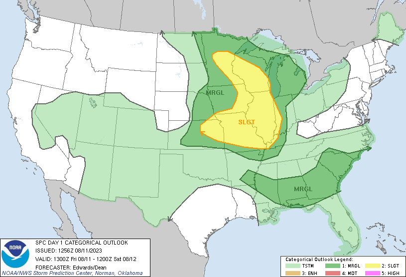 |
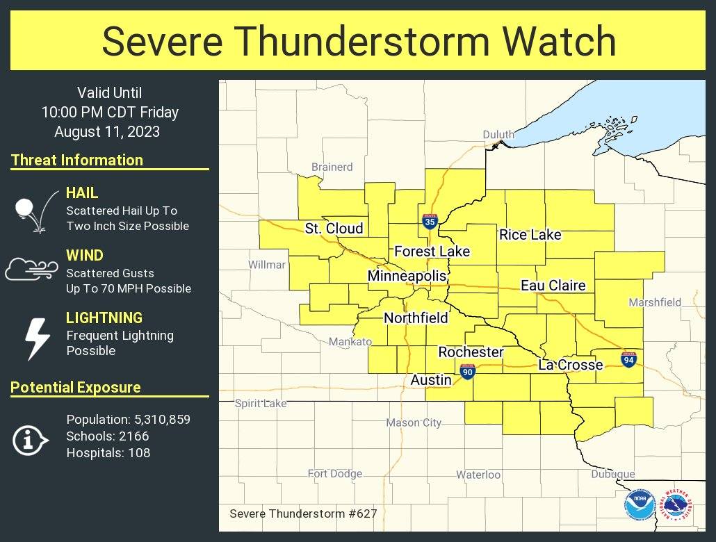
| Weather Story graphic issued August 11 | Graphic highlighting developing storms during the evening of August 11 | Severe thunderstorm watch issued on August 11, 2023 | SPC Day 1 convective outlook issued August 11, 2023 |
 |
Media use of NWS Web News Stories is encouraged! Please acknowledge the NWS as the source of any news information accessed from this site. |
|


 Weather Story
 Weather Map
 Local Radar